
Wallace, Idaho is a city in and the county seat of Shoshone County, Idaho, in the Silver Valley mining district of the Idaho Panhandle. Founded in 1884, Wallace sits alongside the South Fork of the Coeur d'Alene River. The town's population was 784 at the 2010 census.

The Great Northern Railway was an American Class I railroad. Running from Saint Paul, Minnesota, to Seattle, Washington, it was the creation of 19th-century railroad entrepreneur James J. Hill and was developed from the Saint Paul & Pacific Railroad. The Great Northern's route was the northernmost transcontinental railroad route in the U.S.

The Burlington Northern Railroad was a United States-based railroad company formed from a merger of four major U.S. railroads. Burlington Northern operated between 1970 and 1995.

The Chicago, Milwaukee, St. Paul and Pacific Railroad (CMStP&P), better known as the Milwaukee Road, was a Class I railroad that operated in the Midwest and Northwest of the United States from 1847 until 1986.

The Empire Builder is a daily long-distance passenger train operated by Amtrak between Chicago and either Seattle or Portland via two sections west of Spokane. Introduced in 1929, it was the flagship passenger train of the Great Northern Railway and was retained by Amtrak when it took over intercity rail service in 1971.

The North Coast Hiawatha was a long-distance passenger train operated by Amtrak between Chicago, Illinois, and Seattle, Washington.

The Great Fire of 1910 was a wildfire in the Inland Northwest region of the United States that in the summer of 1910 burned three million acres in North Idaho and Western Montana, with extensions into Eastern Washington and Southeast British Columbia. The area burned included large parts of the Bitterroot, Cabinet, Clearwater, Coeur d'Alene, Flathead, Kaniksu, Kootenai, Lewis and Clark, Lolo, and St. Joe national forests. The fire burned over two days on the weekend of August 20–21, after strong winds caused numerous smaller fires to combine into a firestorm of unprecedented size. It killed 87 people, mostly firefighters, destroyed numerous manmade structures, including several entire towns, and burned more than three million acres of forest with an estimated billion dollars' worth of timber lost. It is believed to be the largest, although not the deadliest, forest fire in U.S. history.

The Olympian and its successor the Olympian Hiawatha were passenger trains operated by the Chicago, Milwaukee, St. Paul and Pacific Railroad between Chicago and the Pacific Northwest. The Olympian operated from 1911 to 1947 and was, along with its running mate the Columbian, the first all-steel train to operate in the Pacific Northwest. The streamlined Olympian Hiawatha operated from 1947 to 1961 and was one of several Milwaukee Road trains to carry the name "Hiawatha". The Olympian Hiawatha was designed by industrial designer Brooks Stevens and included the distinctive glassed-in "Skytop" observation-sleeping cars. It later featured full-length "Super Dome" cars.

Avery is a small unincorporated community in the northwest United States, located in the St. Joe River Valley in Shoshone County, Idaho. Avery is located in the middle of the St. Joe District of the Idaho Panhandle National Forest, and is a tourist attraction in the Idaho Panhandle known for its wilderness and outdoor recreation. It is upstream and east of St. Maries, the county seat of Benewah County.
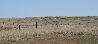
Mullan Road was the first wagon road to cross the Rocky Mountains to the Inland of the Pacific Northwest. It was built by U.S. Army troops under the command of Lt. John Mullan, between the spring of 1859 and summer 1860. It led from Fort Benton, which at the time was in the Dakota Territory, then Idaho Territory from July 1863, and into Montana Territory beginning in May 1864. The road eventually stretched all the way from Fort Walla Walla, Washington Territory, near the Columbia River to the navigational head of the Missouri River, which at the time was the farthest inland port in the world). The road previewed the route approximately followed by modern-day Interstate 15 and Interstate 90 through present-day Montana, Idaho, and Washington.
The Silver Valley is a region in the northwest United States, in the Coeur d'Alene Mountains in northern Idaho. It is noted for its mining heritage, dating back to the 1880s.
Lookout Pass is a mountain pass in the Rocky Mountains of the northwestern United States. In the Coeur d'Alene Mountains of the Bitterroot Range, the pass is on the border between Idaho and Montana, traversed by Interstate 90 at an elevation of 4,710 feet (1,436 m) above sea level.
The Trail of the Coeur d'Alenes is a rail trail in the northwest United States, in northern Idaho. It follows the former Union Pacific Railroad right-of-way from Mullan, a mountain mining town near the Montana border, westward to Plummer, a town on the prairie near the Washington border. Generally following the Coeur d'Alene River, the rail line was abandoned in 1991, and the trail officially opened in March 2004.
Lookout Pass Ski and Recreation Area is a ski area in the western United States. It is at Lookout Pass on Interstate 90, on the border of Idaho and Montana, five miles (8 km) east of Mullan, Idaho. It has a summit elevation of 6,150 ft (1,870 m) on Eagle Peak and 5,650 ft (1,720 m) on Runt Mountain with a vertical drop of 1,650 ft (500 m). Lookout Pass operates seven days per week from mid-December until mid-April.

Interstate 90 (I-90) is a transcontinental Interstate Highway that runs east–west across the northern United States. Within the state of Idaho, the freeway travels for 74 miles (119 km) from the Washington border near Spokane to Coeur d'Alene and the panhandle region at the north end of the state. After traveling through the Silver Valley along the Coeur d'Alene River in the Bitterroot Range, I-90 crosses into Montana at Lookout Pass.
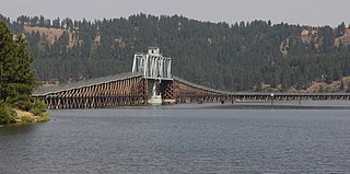
The Chicago, Milwaukee, St. Paul and Pacific Railroad Company Historic District consists of the historic right-of-way of the Chicago, Milwaukee, St. Paul and Pacific Railroad in the Bitterroot Mountains from East Portal, Montana, to the mouth of Loop Creek, Idaho, a distance of 14.5 miles (23.3 km). The district was once part of the railroad's mainline from Chicago, Illinois to Tacoma, Washington.
Milwaukee Ski Bowl was an alpine ski area in the northwest United States in Washington, which operated between 1937 and 1950. It was southeast of Seattle in the Cascade Range at Hyak, on the east side of Snoqualmie Pass.

Transportation in Montana comprises many different forms of travel. Montana shares a long border with Canada, hence international crossings are prevalent in the northern section of the state; there are 13 road crossings and one rail crossing.
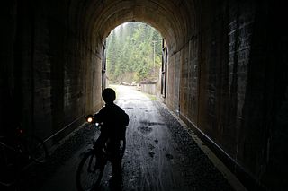
The St. Paul Pass Tunnel was a railway tunnel in the northwest United States at St. Paul Pass, on the Montana-Idaho border. The tunnel was on the main line of the Chicago, Milwaukee, St. Paul & Pacific Railroad, commonly known as "The Milwaukee Road."


