Piers McDonald, OC is a Yukon politician and businessman. Born in Kingston, Ontario, McDonald, originally a miner by profession, is a long-time MLA, Cabinet minister, and Premier of the Yukon. He was leader of the Yukon New Democratic Party from 1995-2000.
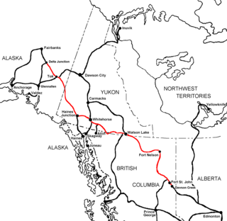
Elsa is a privately owned mining town based on silver, lead, and zinc in Yukon, Canada. It is located between the valley of the Stewart River to the south and the Mackenzie Mountains to the north. It is 700 kilometres (435 mi) to the north of Whitehorse, and 600 km (373 mi) east of the Alaskan border. It is located at Mile 60.3 of the Silver Trail, Yukon Highway 11.
The Ta'an Kwach'an Council or Ta'an Kwäch’än Council is a First Nation band government in Whitehorse and Lake Laberge area in Canada's Yukon Territory. It split from the Kwanlin Dün First Nation to negotiate a separate land claim. The language originally spoken by the Ta’an Kwäch’än was Southern Tutchone. The Ta’an Kwäch’än comprise people of Southern Tutchone, Tagish and Tlingit descent. Approximately 50 per cent of the Ta’an Kwäch’än citizens now live in Whitehorse, Yukon Territory, with the balance disbursed throughout the rest of Canada, in the United States of America, and abroad. The Ta'an Kwäch’än take their name from Tàa'an Män in the heart of their traditional territory - so they called themselves ″People from Lake Laberge″.
Ibex Valley is a hamlet in Canada's Yukon. The hamlet is considered a local advisory area with an advisory council providing local government. Its population in 2001 according to the Canada 2001 Census was 315.
Mount Lorne is a hamlet in Canada's Yukon. The hamlet is considered a local advisory area with an advisory council providing local government. Its population in 2001 according to the Census was 379.
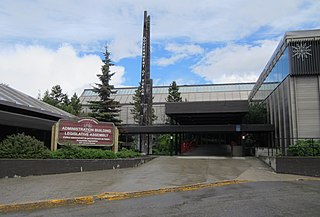
The Yukon Legislative Building is home to the Yukon Legislative Assembly. Located in Whitehorse, Yukon, the building is a three-storey white steel-clad structure. The complex is located next to the Yukon River and Rotary Park.

McIntyre-Takhini is an electoral district which returned a member to the Legislative Assembly of the Yukon Territory in Canada. It was dissolved in 2009 into the ridings Takhini-Kopper King and Mountainview. It contained the Whitehorse subdivisions of Takhini, Valleyview, and McIntyre, as well as the Kopper King, Takhini, and Northland mobile home parks.

Lake Laberge is an electoral district which returns a member to the Legislative Assembly of the Yukon Territory in Canada. It is one of the Yukon's eight rural districts and is named after the eponymous Lake Laberge, which is within the riding.
CIAY-FM, branded as Life 100.7, is a Christian radio station in Whitehorse, Yukon, Canada. CIAY-FM broadcasts at 100.7 FM airing a combination of religious programming and Contemporary Christian music.
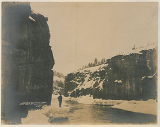
The Miles Canyon Basalts represent a package of rocks that include various exposures of basaltic lava flows and cones that erupted and flowed across an ancient pre-glacial landscape in south-central Yukon.
Riverdale is a neighbourhood within the city of Whitehorse, Yukon, Canada. The community is separated from Whitehorse City Centre by the Yukon River, and is linked to Whitehorse via Lewes Boulevard, a major thoroughfare in the community.
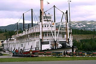
SS Klondike was the name of two sternwheelers, the second now a national historic site located in Whitehorse, Yukon, Canada. Both ran freight between Whitehorse and Dawson City along the Yukon River from 1929-1936 and 1937-1950, respectively.

Braeburn Lodge is a roadhouse on the Klondike Highway in the Yukon Territory of Canada. It is located east of Braeburn Lake and north of Braeburn Mountain, on the path of the former Dawson Overland Trail, which was built in 1902 between Whitehorse and Dawson City. The lodge itself is a tourist destination and is famous for its large cinnamon buns. Nearby Cinnamon Bun Airport is named for the lodge's cinnamon buns. Every February, Braeburn Lodge hosts a checkpoint of the long-distance Yukon Quest sled dog race.
Kusawa Lake is a lake in the southern Yukon, Canada. Kusawa means "long narrow lake" in the Tlingit language. The Kusawa Lake is a lake in Canada's Yukon Territory. It is located at an altitude of 671 m (2,201 ft) and is 60 km (37 mi) southwest of Whitehorse near the British Columbia border. It meanders over a length of 75 km (47 mi) with a maximum width of about 2.5 km (1.6 mi) through the mountains in the north of the Boundary Ranges. It is fed by the Primrose River and Kusawa River. The Takhini outflows to the Yukon River from the northern tip of Kusawa Lake. Kusawa Lake has an area of 142 km2 (55 sq mi). The lake has a maximum depth of 140 m (460 ft) and is of glacial origin. It is a common tourist destination and is also popular for fishing.

The Whitehorse Waterfront Trolley is a heritage streetcar service in Whitehorse, Yukon, Canada.

The Yukon Beringia Interpretive Centre is a research and exhibition facility located at km 1423 on the Alaska Highway in Whitehorse, Yukon, which opened in 1997. The focus of the interpretive centre is the story of Beringia, the 3200 km landmass stretching from the Kolyma River in Siberia to the MacKenzie River in Canada, which remained non-glaciated during the Pleistocene due to light snowfall from an arid climate. Beringia is of special interest to archeologists and paleontologists as it played a crucial role in the migrations of many animals and humans between Asia and the Americas. The term Beringia was first coined by the Swedish botanist Eric Hultén in 1937.
Kate White is a Canadian politician, who was elected to in the Yukon Legislative Assembly in the 2011 election. She represents the Whitehorse electoral district of Takhini-Kopper King as a member of the Yukon New Democratic Party caucus.
Takhini-Kopper King is an electoral district which returns a member to the Legislative Assembly of Yukon in Canada. It was created in 2009 out of much of the former riding of McIntyre-Takhini. The riding includes the Whitehorse subdivisions of Takhini and Raven's Ridge, as well as the Kopper King, Takhini, and Northland mobile home parks and the residences along the Fish Lake Road.