Taxiway

Last updated
F-22 Raptors taxiing at Elmendorf AFB, Alaska, US F-22A Elmendorf AFB.jpg
F-22 Raptors taxiing at Elmendorf AFB, Alaska, US
Aircraft taxiing to runway, at Dubai Airport Dubai Airport 16.08.2009 05-08-19.jpg
Aircraft taxiing to runway, at Dubai Airport
A taxiway crossing the Autobahn Leipzig-Halle Airport Condor.jpg
A taxiway crossing the Autobahn
Taxiway at Munich Airport Munich Airport Apron.jpg
Taxiway at Munich Airport
Holding Position Marking on a taxiway at Mumbai Airport Mumbai Airport Holding Position.png
Holding Position Marking on a taxiway at Mumbai Airport
Holding position sign (red sign saying "ILS") and marking (in front of the red plane) for instrument landing system (ILS) critical area boundary Holding position sign and marking for instrument landing system (ILS) critical area boundary.png
Holding position sign (red sign saying "ILS") and marking (in front of the red plane) for instrument landing system (ILS) critical area boundary

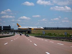
A taxiway is a path for aircraft at an airport connecting runways with aprons, hangars, terminals and other facilities. They mostly have a hard surface such as asphalt or concrete, although smaller general aviation airports sometimes use gravel or grass.

Contents

Most airports do not have a specific speed limit for taxiing (though some do). There is a general rule on safe speed based on obstacles. Operators and aircraft manufacturers might have limits. Typical taxi speeds are 20–30 knots (37–56 km/h; 23–35 mph). [1] [2]

High-speed exit

Busy airports typically construct high-speed or rapid-exit taxiways to allow aircraft to leave the runway at higher speeds. This allows the aircraft to vacate the runway quicker, permitting another to land or take off in a shorter interval of time. This is accomplished by reducing the angle the exiting taxiway intercepts the runway at to 30 degrees, instead of 90 degrees, thus increasing the speed at which the aircraft can exit the runway onto the taxiway. [3]

Markings

The taxiways are given alphanumeric identification. These taxiway IDs are shown on black and yellow signboards along the taxiways.

Signs

Airport guidance signs provide direction and information to taxiing aircraft and airport vehicles. Smaller airports may have few or no signs, relying instead on airport diagrams and charts.

Airport location sign.svg
Location Sign for a Taxiway
Airport direction sign.svg
Direction Sign Onto Taxiway Bravo
Airport no entry sign.svg
No Entry Sign

There are two classes of signage at airports, with several types of each:

The signs can often be combined, in this case a direction sign, a location sign, and a runway sign. Ben Gurion International Airport taxiway signs.JPG
The signs can often be combined, in this case a direction sign, a location sign, and a runway sign.

Operational guidance signs

The yellow "W2" direction sign in the foreground leading to the black "W2" location sign in the background. The blue "SW 2" sign is non-standard. Ben Gurion International Airport 4 taxiway signs.JPG
The yellow "W2" direction sign in the foreground leading to the black "W2" location sign in the background. The blue "SW 2" sign is non-standard.

Mandatory instruction signs

Mandatory instruction signs are white on red. They show entrances to runways or critical areas. Vehicles and aircraft are required to stop at these signs until the control tower gives clearance to proceed.

Lights

For night operations, taxiways at major airports are equipped with lights, although many small airports are not equipped with taxiway lighting.

See also

Related Research Articles

<span class="mw-page-title-main">Runway</span> Area of surface used by aircraft to takeoff from and land on

According to the International Civil Aviation Organization (ICAO), a runway is a "defined rectangular area on a land aerodrome prepared for the landing and takeoff of aircraft". Runways may be a human-made surface or a natural surface. Runways, taxiways and ramps, are sometimes referred to as "tarmac", though very few runways are built using tarmac. Takeoff and landing areas defined on the surface of water for seaplanes are generally referred to as waterways. Runway lengths are now commonly given in meters worldwide, except in North America where feet are commonly used.

<span class="mw-page-title-main">Instrument landing system</span> Ground-based visual aid for landing

In aviation, the instrument landing system (ILS) is a precision radio navigation system that provides short-range guidance to aircraft to allow them to approach a runway at night or in bad weather. In its original form, it allows an aircraft to approach until it is 200 feet (61 m) over the ground, within a 12 mile (800 m) of the runway. At that point the runway should be visible to the pilot; if it is not, they perform a missed approach. Bringing the aircraft this close to the runway dramatically increases the range of weather conditions in which a safe landing can be made. Other versions of the system, or "categories", have further reduced the minimum altitudes, runway visual ranges (RVRs), and transmitter and monitoring configurations designed depending on the normal expected weather patterns and airport safety requirements.

<span class="mw-page-title-main">Airfield traffic pattern</span> Standard aircraft path

An airfield traffic pattern is a standard path followed by aircraft when taking off or landing while maintaining visual contact with the airfield.

<span class="mw-page-title-main">Navigation light</span> Lights on a vessel, aircraft or spacecraft giving information on its position, heading, and status

A navigation light, also known as a running or position light, is a source of illumination on a watercraft, aircraft or spacecraft, meant to give information on the craft's position, heading, or status. Some navigation lights are colour-coded red and green to aid traffic control by identifying the craft's orientation. Their placement is mandated by international conventions or civil authorities such as the International Maritime Organization (IMO).

<span class="mw-page-title-main">Laughlin/Bullhead International Airport</span> Airport in Mohave County, Arizona

Laughlin/Bullhead International Airport is a public use airport located 1.15 miles north of the central business district of Bullhead City, in Mohave County, Arizona, United States. It is owned by Mohave County. The airport is across the Colorado River and one block away from Laughlin, Nevada. Many of the rooms at Laughlin's casino-hotels offer a view of the airport. It was named 2011 Airport of the Year by the Arizona Department of Transportation.

<span class="mw-page-title-main">Los Angeles runway disaster</span> 1991 runway collision between two airplanes

On the evening of February 1, 1991, USAir Flight 1493, a Boeing 737-300, collided with SkyWest Airlines Flight 5569, a Fairchild Swearingen Metroliner turboprop aircraft, upon landing at Los Angeles International Airport (LAX). As Flight 1493 was on final approach, the local controller was distracted, though air traffic was not heavy at LAX, by a series of abnormalities, including a misplaced flight progress strip and an aircraft that had inadvertently switched off the tower frequency. The SkyWest flight was told to taxi into takeoff position, while the USAir flight was landing on the same runway.

Land and Hold Short Operations is an air traffic control procedure for aircraft landing and holding short of an intersecting runway or point on a runway, to balance airport capacity and system efficiency with safety.

Lima Allen County Airport is a publicly owned, public use airport located six miles southeast of Lima in Allen County, Ohio. It is owned by the Allen County Regional Airport Authority.

A displaced threshold or DTHR is a runway threshold located at a point other than the physical beginning or end of the runway.

<span class="mw-page-title-main">Airport apron</span> Area at an airport used by aircraft for parking, loading, fueling, and maintenance

The airport apron, apron, flight line, or ramp is the area of an airport where aircraft are parked, unloaded or loaded, refueled, boarded, or maintained. Although the use of the apron is covered by regulations, such as lighting on vehicles, it is typically more accessible to users than the runway or taxiway. However, the apron is not usually open to the general public, and a permit may be required to gain access. An apron's designated areas for aircraft parking are called aircraft stands.

<span class="mw-page-title-main">Road signs in Sweden</span> Overview of road signs in Sweden

Road signs in Sweden are regulated in Vägmärkesförordningen, VMF (2007:90), and are to be placed 2 metres from the road with the sign 1.6 m from the base for motorized roads. Except for route numbers, there are a maximum of three signs on a pole, with the most important sign at the top. All signs have a reflective layer added on selected parts of the sign as is custom in European countries; most larger signs also have their own illumination.

Tri-Cities Airport is a village-owned, public-use airport located three nautical miles (6 km) southwest of the central business district of Endicott, a village in Broome County, New York, United States. According to the FAA's National Plan of Integrated Airport Systems for 2009–2013, it is classified as a general aviation airport.

Safford Regional Airport is in Graham County, Arizona, United States, 3 miles east of Safford, which owns it. The FAA's National Plan of Integrated Airport Systems for 2009–2013 categorizes it as a general aviation facility. It is the only paved airport in Graham County.

<span class="mw-page-title-main">Approach lighting system</span> Runway lighting installed on the approach end which extends beyond the runway

An approach lighting system (ALS) is a lighting system installed on the approach end of an airport runway and consisting of a series of lightbars, strobe lights, or a combination of the two that extends outward from the runway end. ALS usually serves a runway that has an instrument approach procedure (IAP) associated with it and allows the pilot to visually identify the runway environment and align the aircraft with the runway upon arriving at a prescribed point on an approach.

<span class="mw-page-title-main">Runway status lights</span> Aviation safety system

Runway Status Lights (RWSL) are a visual alerting system installed in some airport taxiways and runways for the purpose of collision-avoidance. When illuminated, red high-intensity LEDs indicate the presence of another vehicle either departing, occupying, or landing on an active runway. RWSL systems are fully-automated and intended to alert aircrews and ground vehicle operators of a potential runway incursion hazard. They operate as an additional layer of safety, independent of human-issued air traffic control clearances.

This article describes the graphic conventions used in Sectional charts and Terminal area charts published for aeronautical navigation under Visual Flight Rules in the United States of America. The charts are published "in accordance with Interagency Air Cartographic Committee specifications and agreements, approved by the Department of Defense and the Federal Aviation Administration".

<span class="mw-page-title-main">Road signs in Poland</span> Overview of road signs of Poland

The design of road signs in Poland is regulated by Regulation of the Ministers of Infrastructure and Interior Affairs and Administration on road signs and signals. The Annex 1 to the regulation describes conditions related to usage of the road signs – size, visibility, colors and light reflections, typeface and text, criteria of choosing the type of foil to signs faces, colorful specimens and schematics.

<span class="mw-page-title-main">Continental Airlines Flight 1883</span> 2006 aviation incident

Continental Airlines Flight 1883 was a Boeing 757 that mistakenly landed on a taxiway at Newark Liberty International Airport on the evening of October 28, 2006. There were no reported injuries or damage, but the narrowly averted disaster was investigated by the National Transportation Safety Board, and caused the Federal Aviation Administration to reevaluate and modify air and ground safety procedures at and around Newark Airport.

Road traffic control devices are markers, signs and signal devices used to inform, guide and control traffic, including pedestrians, motor vehicle drivers and bicyclists. These devices are usually placed adjacent, over or along the highways, roads, traffic facilities and other public areas that require traffic control.

<span class="mw-page-title-main">1983 Anchorage runway collision</span> Aviation accident in 1983

On 23 December 1983, Korean Air Lines Flight 084 (KAL084), a McDonnell Douglas DC-10-30CF performing a cargo flight, collided during its takeoff roll with SouthCentral Air Flight 59 (SCA59), a Piper PA-31-350, on runway 06L/24R at Anchorage International Airport, as a result of the KAL084 flight crew becoming disoriented while taxiing in dense fog and attempting to take off on the wrong runway. Both aircraft were destroyed, but no fatalities resulted.

References

  1. "Airplanes: At what speed do planes generally taxi?". February 9, 2016. Retrieved January 1, 2018.
  2. John Cox (November 23, 2014). "Ask the Captain: Making time on the taxiways". USA Today . Retrieved January 1, 2018.
  3. "FAA TV: High Speed Exit Taxiways". www.faa.gov. Retrieved 2021-03-25.
  4. "FAA Advisory Circular No: 150/5340-1J March 31, 2008 – Standards for Airport Markings" . Retrieved January 1, 2018. (canceled and replaced by150/5340-1K)
  5. "Chapter 14: Airport Operations". Pilot's Handbook of Aeronautical Knowledge (FAA-H-8083-25C ed.). Federal Aviation Administration. 2023-07-17. p. 12.
  6. "AIP Israel Amendment 2.5-1". December 16, 2010. Retrieved January 1, 2018. (LLBG AD 2.9 Surface Movement Guidance and Control System and Markings)
  7. , Page 2-7, Table 2-1.

https://www.faa.gov/documentLibrary/media/Advisory_Circular/150-5340-30J.pdf