Taylor Creek, Florida

Last updated
Taylor Creek, Florida
CDP
Okeechobee County Florida Incorporated and Unincorporated areas Taylor Creek Highlighted.svg
Location in Okeechobee County and the state of Florida
Coordinates: 27°13′00″N80°47′22″W / 27.21667°N 80.78944°W / 27.21667; -80.78944 [1]
Country United States
State Florida
County Okeechobee
Area
[2]
  Total3.44 sq mi (8.91 km2)
  Land3.05 sq mi (7.89 km2)
  Water0.39 sq mi (1.01 km2)
Elevation
[1]
16 ft (5 m)
Population
 (2020)
  Total4,470
  Density1,466.54/sq mi (566.19/km2)
Time zone UTC-5 (Eastern (EST))
  Summer (DST) UTC-4 (EDT)
ZIP code
34974 [3]
Area code 863
FIPS code 12-71300 [4]
GNIS feature ID1867217 [1]

Taylor Creek is a census-designated place (CDP) in Okeechobee County, Florida, United States. The population was 4,348 at the 2010 census.

Contents

Geography

The community lies along the north side of Lake Okeechobee. The area is served by US routes 98 and 441 and state routes 700 and 15. [5]

According to the United States Census Bureau, the CDP has a total area of 4.2 square miles (11 km2), of which 4.0 square miles (10 km2) is land and 0.2 square miles (0.52 km2) (3.61%) is water.

History

In 1855, Taylor Creek was the site for a meeting of Seminole. The aim of the meeting was to discuss how the confederation should respond to increasing pressure from the United States government, and the result was the start of the Third Seminole War. [6]

In October 1896, the first Euro-American settlers, Peter and Louisiana Raulerson, moved down to the area from Fort Basinger, Florida. [7]

Demographics

Historical population
CensusPop.Note
2000 4,289
2010 4,3481.4%
2020 4,4702.8%
U.S. Decennial Census [8]

As of the census [4] of 2000, there were 4,289 people, 2,022 households, and 1,277 families residing in the CDP. The population density was 1,073.2 inhabitants per square mile (414.4/km2). There were 2,775 housing units at an average density of 694.4 per square mile (268.1/km2). The racial makeup of the CDP was 94.54% White, 0.26% African American, 0.42% Native American, 0.61% Asian, 0.05% Pacific Islander, 3.12% from other races, and 1.00% from two or more races. Hispanic or Latino of any race were 5.15% of the population.

There were 2,022 households, out of which 14.7% had children under the age of 18 living with them, 52.4% were married couples living together, 6.6% had a female householder with no husband present, and 36.8% were non-families. 29.6% of all households were made up of individuals, and 16.2% had someone living alone who was 65 years of age or older. The average household size was 2.12 and the average family size was 2.54.

In the CDP, the population was spread out, with 14.6% under the age of 18, 5.9% from 18 to 24, 18.2% from 25 to 44, 28.1% from 45 to 64, and 33.1% who were 65 years of age or older. The median age was 55 years. For every 100 females, there were 103.5 males. For every 100 females age 18 and over, there were 101.0 males.

The median income for a household in the CDP was $24,919, and the median income for a family was $28,260. Males had a median income of $23,810 versus $22,500 for females. The per capita income for the CDP was $16,754. About 10.1% of families and 15.2% of the population were below the poverty line, including 22.8% of those under age 18 and 6.2% of those age 65 or over.

Related Research Articles

<span class="mw-page-title-main">Glades County, Florida</span> County in Florida, United States

Glades County is a county located in the Florida Heartland region of the U.S. state of Florida. As of the 2020 census, the population was 12,126, making it the fourth-least populous county in Florida. Its county seat is Moore Haven.

<span class="mw-page-title-main">Okeechobee County, Florida</span> County in Florida, United States

Okeechobee County is a county located in the Florida Heartland region of the state of Florida. As of the 2020 census, the population was 39,644. The county seat is Okeechobee.

Ridgeway is a census-designated place (CDP) in Kenai Peninsula Borough, Alaska, United States. At the 2020 census the population was 2,136, up from 2,022 in 2010.

<span class="mw-page-title-main">Laguna Beach, Florida</span> Census-designated place in Florida, United States

Laguna Beach is a census-designated place (CDP) in Bay County, Florida, United States. The population was 3,932 at the 2010 census. It is part of the Panama City–Lynn Haven–Panama City Beach Metropolitan Statistical Area. Laguna Beach was named for the many coastal dune lakes unique to this area of Northwest Florida.

<span class="mw-page-title-main">Buckhead Ridge, Florida</span> CDP in Florida, United States

Buckhead Ridge is a census-designated place (CDP) in Glades County, Florida, United States. The population was 1,450 at the 2010 census. The community consists of a few small commercial developments and a large mobile home park. Most residential lots in the community abut canals that feed into Lake Okeechobee.

<span class="mw-page-title-main">Clewiston, Florida</span> City in Florida, United States

Clewiston is a city in Hendry County, Florida, United States. Its location is 80 miles (130 km) northwest of Fort Lauderdale on the Atlantic coastal plain. The population was 7,327 at the 2020 census, up from 7,155 at the 2010 census. The estimated population in 2018 was 7,985. The city is located on the south bank of Lake Okeechobee, and the Lake Okeechobee Scenic Trail (LOST) passes through the edge of the city. The city is home to Billie Swamp Safari, the Clewiston Museum and the Dixie Crystal Theatre. The area has been home to Seminole tribe members and sugar plantations, with the Ah-Tah-Thi-Ki Seminole Indian Museum located 32 miles (51 km) south of the city.

<span class="mw-page-title-main">Istachatta, Florida</span> Census-designated place in Florida, United States

Istachatta is an unincorporated community and census-designated place (CDP) in Hernando County, Florida, United States. The population was 116 at the 2010 census, up from 65 at the 2000 census. The name "Istachatta" is derived from a Seminole word meaning "man snake".

<span class="mw-page-title-main">Thonotosassa, Florida</span> Census-designated place in Florida, United States

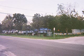
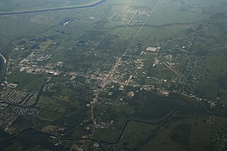
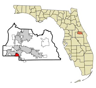
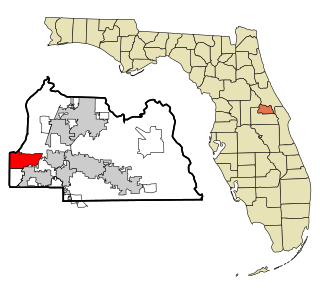
Thonotosassa is a census-designated place (CDP) in Hillsborough County, Florida, United States. The population was 15,238 at the 2020 census, up from 13,014 at the 2010 census.

<span class="mw-page-title-main">San Carlos Park, Florida</span> Census-designated place in Florida, United States

San Carlos Park is a census-designated place (CDP) in Lee County, Florida, United States. The population was 18,563 at the 2020 census. It is part of the Cape Coral-Fort Myers, Florida Metropolitan Statistical Area.

<span class="mw-page-title-main">St. James City, Florida</span> Census-designated place in Florida, United States

St. James City is an unincorporated community and census-designated place (CDP) on Pine Island in Lee County, Florida, United States. The population was 3,876 at the 2020 census, up from 3,784 at the 2010 census. It is part of the Cape Coral-Fort Myers, Florida Metropolitan Statistical Area.

<span class="mw-page-title-main">Tice, Florida</span> Census-designated place in Florida, United States

Tice is an unincorporated community and census-designated place (CDP) in Lee County, Florida, United States. As of the 2020 census, the CDP population was 4,853. It is part of the Cape Coral-Fort Myers, Florida Metropolitan Statistical Area.

<span class="mw-page-title-main">Whiskey Creek, Florida</span> Census-designated place in Florida, United States

Whiskey Creek is a census-designated place (CDP) in Lee County, Florida, United States. The population was 4,842 at the 2020 census. It is part of the Cape Coral-Fort Myers, Florida Metropolitan Statistical Area.

<span class="mw-page-title-main">Cypress Quarters, Florida</span> CDP in Florida, United States

Cypress Quarters is a census-designated place (CDP) in Okeechobee County, Florida, United States. The population was 1,215 at the 2010 census.

<span class="mw-page-title-main">Okeechobee, Florida</span> City in Florida, United States

Okeechobee is a city in and the county seat of Okeechobee County, Florida, United States. As of the 2020 United States Census, the city's population was 5,254.

<span class="mw-page-title-main">Lake Harbor, Florida</span> CDP in Florida, United States

Lake Harbor is a census-designated place (CDP) in Palm Beach County, Florida, United States. The population was 49 at the 2020 census. It located along the southern banks of Lake Okeechobee, at the beginning of the Miami Canal. John Stretch Park is also located alongside the north end of Lake Harbor and the lake.

<span class="mw-page-title-main">Fern Park, Florida</span> Census-designated place & unincorporated community in Florida, United States

Fern Park is a census-designated place and a suburban unincorporated community in Seminole County, Florida, United States. The population was 8,318 at the 2000 census. It is part of the Orlando–Kissimmee Metropolitan Statistical Area.

<span class="mw-page-title-main">Forest City, Florida</span> CDP in Florida, United States

Forest City is a census-designated place and an area in Seminole County, Florida, United States. Its historic center is now in the City of Altamonte Springs. Data in this article deals only with the unincorporated section. The population was 12,612 at the 2000 census. It is part of the Orlando–Kissimmee Metropolitan Statistical Area.

<span class="mw-page-title-main">Wekiwa Springs, Florida</span> CDP in Florida, United States

Wekiwa Springs is a census-designated place and an unincorporated area in Seminole County, Florida, United States. The population was 23,169 at the 2000 census. It is part of the Orlando–Kissimmee–Sanford, Florida Metropolitan Statistical Area.

<span class="mw-page-title-main">Samsula-Spruce Creek, Florida</span> CDP in Florida, United States

Samsula-Spruce Creek is a census-designated place (CDP) in Volusia County, Florida, United States. The population was 5,047 at the 2010 census. While many households reside here, it is principally an agricultural area west of the cities of Port Orange and New Smyrna Beach.

<span class="mw-page-title-main">Big Coppitt Key</span> Census-designated place in Florida, United States

Big Coppitt Key is an island in Monroe County, Florida, United States, in the lower Florida Keys. The name is said to be a derivation of the old English word "coppice", meaning thicket. According to A.D. Bache, in the notes for his coast survey conducted in 1861, this key was the location of Happy Jack's plantation in 1855.

References

  1. 1 2 3 U.S. Geological Survey Geographic Names Information System: Taylor Creek, Florida
  2. "2020 U.S. Gazetteer Files". United States Census Bureau. Retrieved December 2, 2021.
  3. "Taylor Creek FL ZIP Code". zipdatamaps.com. 2023. Retrieved February 17, 2023.
  4. 1 2 "U.S. Census website". United States Census Bureau . Retrieved 2008-01-31.
  5. Okeechobee, Florida, 7.5 Minute Quadrangle, USGS, 1953 (1987 rev.)
  6. Covington, James W. (1966). "An Episode in the Third Seminole War". The Florida Historical Quarterly. 45 (1): 45–59. ISSN   0015-4113 . Retrieved 13 January 2022.
  7. "Peter and Louisiana Chandler Raulerson Log Cabin Historic Site". THE HISTORICAL MARKER DATABASE. Retrieved 13 January 2022.
  8. "Census of Population and Housing". Census.gov. Retrieved June 4, 2016.