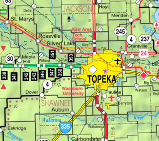
Topeka is the capital city of the U.S. state of Kansas and the seat of Shawnee County. It is along the Kansas River in the central part of Shawnee County, in northeast Kansas, in the Central United States. As of the 2020 census, the population of the city was 126,587. The Topeka metropolitan statistical area, which includes Shawnee, Jackson, Jefferson, Osage, and Wabaunsee Counties, had a population of 233,870 in the 2010 census.

Wabaunsee County is a county located in the U.S. state of Kansas. Its county seat is Alma. As of the 2020 census, the county population was 6,877. The county was named for Chief Waubonsie of the Potawatomi Indians.

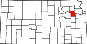
Shawnee County is located in northeast Kansas, in the central United States. Its county seat and most populous city is Topeka, the state capital. As of the 2020 census, the population was 178,909, making it the third-most populous county in Kansas. The county was one of the original 33 counties created by the first territorial legislature in 1855, and it was named for the Shawnee tribe.

Pottawatomie County is a county located in the U.S. state of Kansas. Its county seat is Westmoreland. As of the 2020 census, the county population was 25,348. The county was named for the Potawatomi tribe.

Osage County is a county located in the U.S. state of Kansas. Its county seat is Lyndon, and its most populous city is Osage City. As of the 2020 census, the county population was 15,766. The county was originally organized in 1855 as Weller County, then renamed in 1859 after the Osage tribe.

Nemaha County is a county located in the northeastern part of the U.S. state of Kansas. Its county seat is Seneca. As of the 2020 census, the county population was 10,273. The county was named for the Nemaha River.
Jefferson County is a county located in the U.S. state of Kansas. Its county seat and most populous city is Oskaloosa. As of the 2020 census, the county population was 18,368. The county was named after Thomas Jefferson, the 3rd president of the United States.

Ellis County is a county located in the U.S. state of Kansas. Its county seat and most populous city is Hays. As of the 2020 census, the county population was 28,934. The county was named for George Ellis, a first lieutenant of the Twelfth Kansas Infantry. Ellis County is the official German Capital of Kansas. German immigrants settled in Hays, Ellis, Victoria, and nearby villages in the 1870s and 1880s.

Cheyenne County is a county located in the northwest corner of the U.S. state of Kansas. Its county seat and most populous city is St. Francis. As of the 2020 census, the county population was 2,616. The county was named after the Cheyenne tribe.
Dover is an unincorporated community in Shawnee County, Kansas, United States. It is located southwest of Topeka.

Silverdale is an unincorporated community in Silverdale Township, Cowley County, Kansas, United States. As of the 2020 census, the population of the community and nearby areas was 61.

Talmage is an unincorporated community in Dickinson County, Kansas, United States. As of the 2020 census, the population of the city was 78.

Berryton is an unincorporated community in Shawnee County, Kansas, United States. It is located east of the Topeka Regional Airport.

Big Springs is an unincorporated community in northwest Douglas County, Kansas, United States.

Petrolia is an unincorporated community in Allen County, Kansas, United States. It is situated along the Neosho River.

Lecompton Township is a township in Douglas County, Kansas, USA. As of the 2000 census, its population was 1,761.

Grantville is an unincorporated community in Jefferson County, Kansas, United States. As of the 2020 census, the population of the community and nearby areas was 182. It is located east of Topeka on the south side of US-24 highway between Barton Rd and KOA/Wilson Rd.
Shawnee Heights USD 450 is a public unified school district headquartered in Tecumseh, Kansas, United States. The district includes the communities of southeast edge of Topeka, Tecumseh, Berryton, Watson, and nearby rural areas. The Shawnee Heights School District is a 5A school district that includes a total of 4 Elementary Schools, 1 Middle School, and 1 High School. Shawnee Heights School District is a suburban school district located in southeastern Shawnee County. The District has an estimated total of 3,500 Students from Pre-Kindergarten to 12th Grade. Tim Hallacy is the superintendent for the School District.
Wakarusa is an unincorporated community in Shawnee County, Kansas, United States. As of the 2020 census, the population of the community and nearby areas was 242. It is located 11 miles (18 km) south of downtown Topeka. Wakarusa is also the name of an unincorporated community in adjacent Douglas County, Kansas, 6.6 mi (10.6 km) southwest of downtown Lawrence and the name of the township that includes Lawrence, Kansas.

Rock Creek is an unincorporated community in Rock Creek Township, Jefferson County, Kansas, United States. It is located along 110th Road near its intersection with K-4.