Templeville, Maryland | |
---|---|
Coordinates: 39°8′11″N75°46′6″W / 39.13639°N 75.76833°W | |
Country | United States |
State | Maryland |
Counties | Queen Anne's, Caroline |
Incorporated | 1865 [1] |
Area | |
• Total | 0.06 sq mi (0.14 km2) |
• Land | 0.06 sq mi (0.14 km2) |
• Water | 0.00 sq mi (0.00 km2) |
Elevation | 69 ft (21 m) |
Population (2020) | |
• Total | 113 |
• Density | 2,054.55/sq mi (800.51/km2) |
Time zone | UTC-5 (Eastern (EST)) |
• Summer (DST) | UTC-4 (EDT) |
ZIP code | 21670 |
Area code | 410 |
FIPS code | 24-77200 |
GNIS feature ID | 0591398 |
Templeville is a town in Caroline and Queen Anne's counties, Maryland, United States. Templeville is located near the Maryland-Delaware line. The population was 138 at the 2010 census. It was known as Bullock Town until the name was changed in 1847. The name Templeville derives from the Temple family, whose most famous member was Governor William Temple of Delaware.
Originally called "Bullock Town," the town changed its name to "Templeville" in 1847. The name was chosen based on "one of several historic cemeteries located near the town." Templeville was originally incorporated in 1865; the charter was renewed in 1947. [3]
Templeville is located at 39°8′11″N75°46′6″W / 39.13639°N 75.76833°W (39.136330, -75.768398). [4]
According to the United States Census Bureau, the town has a total area of 0.08 square miles (0.21 km2), all land. [5]
The main method of travel to and from Templeville is by road, and two state highways serve the town. Maryland Route 302 traverses the town from east to west, while Maryland Route 454 heads south out of the town from its terminus at MD 302.
Census | Pop. | Note | %± |
---|---|---|---|
1880 | 101 | — | |
1950 | 82 | — | |
1960 | 98 | 19.5% | |
1970 | 102 | 4.1% | |
1980 | 96 | −5.9% | |
1990 | 66 | −31.2% | |
2000 | 80 | 21.2% | |
2010 | 138 | 72.5% | |
2020 | 113 | −18.1% | |
U.S. Decennial Census [6] |
As of the census [7] of 2010, there were 138 people, 39 households, and 27 families living in the town. The population density was 1,725.0 inhabitants per square mile (666.0/km2). There were 43 housing units at an average density of 537.5 per square mile (207.5/km2). The racial makeup of the town was 47.8% White, 0.7% Native American, 50.7% from other races, and 0.7% from two or more races. Hispanic or Latino of any race were 60.1% of the population.
There were 39 households, of which 43.6% had children under the age of 18 living with them, 38.5% were married couples living together, 20.5% had a female householder with no husband present, 10.3% had a male householder with no wife present, and 30.8% were non-families. 25.6% of all households were made up of individuals, and 12.9% had someone living alone who was 65 years of age or older. The average household size was 3.54 and the average family size was 3.89.
The median age in the town was 27.3 years. 27.5% of residents were under the age of 18; 15.9% were between the ages of 18 and 24; 35.4% were from 25 to 44; 14.4% were from 45 to 64; and 6.5% were 65 years of age or older. The gender makeup of the town was 50.7% male and 49.3% female.
As of the census [8] of 2000, there were 80 people, 32 households, and 14 families living in the town. The population density was 1,084.8 inhabitants per square mile (418.8/km2). There were 37 housing units at an average density of 501.7 per square mile (193.7/km2). The racial makeup of the town was 77.50% White, 5.00% African American, 1.25% Native American, 8.75% Asian, 5.00% from other races, and 2.50% from two or more races. Hispanic or Latino of any race were 5.00% of the population.
There were 32 households, out of which 28.1% had children under the age of 18 living with them, 21.9% were married couples living together, 12.5% had a female householder with no husband present, and 56.3% were non-families. 50.0% of all households were made up of individuals, and 31.3% had someone living alone who was 65 years of age or older. The average household size was 2.50 and the average family size was 3.79.
In the town, the population was spread out, with 27.5% under the age of 18, 12.5% from 18 to 24, 26.3% from 25 to 44, 16.3% from 45 to 64, and 17.5% who were 65 years of age or older. The median age was 36 years. For every 100 females, there were 86.0 males. For every 100 females age 18 and over, there were 87.1 males.
The median income for a household in the town was $15,938, and the median income for a family was $24,375. Males had a median income of $26,667 versus $15,625 for females. The per capita income for the town was $10,202. There were 40.0% of families and 40.7% of the population living below the poverty line, including 30.0% of under eighteens and none of those over 64.
Sherman is a town in Aroostook County, Maine, United States. The population was 815 at the 2020 census.
Marydel is an incorporated town in Caroline County, Maryland, United States. The population was 141 at the 2010 United States Census. Its name is a portmanteau, after its location, being partially located in Maryland and partially in Delaware. Marydel was originally known as Halltown.
Hurlock is a town in Dorchester County, Maryland, United States. The population was 2,092 at the 2010 census.
Barclay is a town in Queen Anne's County, Maryland, United States. The population was 120 at the 2010 census.
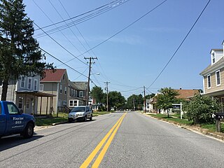
Church Hill is a town in Queen Anne's County, Maryland, United States. The population was 745 at the 2010 census.
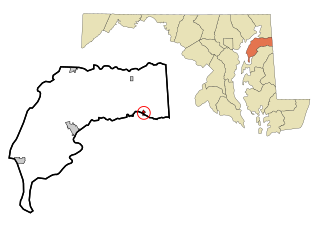
Princess Anne is a town in Somerset County, Maryland, United States, that also serves as its county seat. Its population was 3,290 at the 2010 census. It is included in the Salisbury, Maryland–Delaware Metropolitan Statistical Area. It is home to the University of Maryland Eastern Shore and the Teackle Mansion.
Mardela Springs is a town in Wicomico County, Maryland, United States. The population was 357 at the 2010 census. It is included in the Salisbury, Maryland-Delaware Metropolitan Statistical Area.
Pittsville is a town in Wicomico County, Maryland, United States. The population was 1,417 at the 2010 census. It is included in the Salisbury, Maryland-Delaware Metropolitan Statistical Area.
Sharptown is a town in Wicomico County, Maryland, United States. The population was 651 at the 2010 census. It is included in the Salisbury, Maryland-Delaware Metropolitan Statistical Area.
Willards is a town in Wicomico County, Maryland, United States. The population was 958 at the 2010 census. It is included in the Salisbury, Maryland-Delaware Metropolitan Statistical Area.
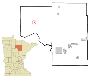
Fountain is a city in Fillmore County, Minnesota, United States. The population was 410 at the 2010 census. Fountain is the western terminus of the Root River segment of the Root River State Trail. Local attractions include the Fillmore County History Center.
Squaw Lake is a city in Itasca County, Minnesota, United States. The population was 98 at the 2020 census.
Henning is a city in Otter Tail County, Minnesota, United States. The population was 854 at the 2020 census.
Twin Lakes is a census-designated place (CDP) in McKinley County, New Mexico, United States. The population was 1,069 at the 2000 census.
Hume is a town in Allegany County, New York, United States. The population was 2,094 at the 2020 census. The town is on the northern border of Allegany County.
Minnewaukan is a city in Benson County, North Dakota, United States. It serves as the county seat and is fourth largest city in the county, after Fort Totten, Leeds, and Maddock. The population was 199 at the 2020 census. Minnewaukan was founded in 1884.
Worthington is a town in Marion County, West Virginia, United States. The population was 158 at the 2010 census. Worthington was incorporated in 1893 and named for Colonel George Worthington, an early settler. U.S. Route 19 passes through the town.
Glen Dale is a city in Marshall County, West Virginia, United States, along the Ohio River. It is part of the Wheeling, West Virginia Metropolitan Statistical Area. The population was 1,514 at the 2020 census. Glen Dale was incorporated in 1924. It is in the northwest part of the county, which is above the Mason–Dixon line and forms the base of the Northern Panhandle of West Virginia.
Pennsboro is a city in Ritchie County, West Virginia, United States. The population was 1,050 at the 2020 census. The city is located at the junction of U.S. Route 50 and West Virginia Route 74; the North Bend Rail Trail also passes through the city.
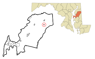
Millington is a town in Kent and Queen Anne's counties in the U.S. state of Maryland. The population was 642 at the 2010 census. Millington is the head of navigation for the Chester River.
{{cite book}}
: CS1 maint: date and year (link)