
Chikamin Peak is a 7,000+ ft mountain summit located in the cascade Range, in Kittitas County of Washington state. It is situated within the Alpine Lakes Wilderness, on land managed by the Okanogan–Wenatchee National Forest. The mountain's name "Chikamin" derives from Chinook Jargon meaning "money" or "metal", and was submitted by Edmond S. Meany, president of The Mountaineers. This name was officially adopted in 1916 by the U.S. Board on Geographic Names. Chikamin Peak is the highest point of Chikamin Ridge, 6 mi (9.7 km) northeast of Snoqualmie Pass. Other notable peaks on Chikamin Ridge include Four Brothers and Three Queens. Precipitation runoff from this mountain drains into tributaries of the Yakima River. The Pacific Crest Trail traverses the southwest slope of Chikamin Ridge, and from the trail a scramble up a gully leads to the summit and several alpine lakes including Chikamin Lake and Spectacle Lake.

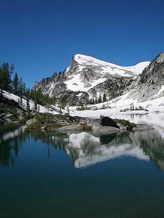
Enchantment Peak is an 8,520+ ft granite summit located in Chelan County of Washington state. Enchantment Peak is part of The Enchantments within the Alpine Lakes Wilderness. Enchantment Peak belongs to the Stuart Range which is subset of the Cascade Range. Enchantment Peak is situated midway between Prusik Peak to its east, and Aasgard Pass and Dragontail Peak to the west. Precipitation runoff drains into Icicle Creek, a tributary of the Wenatchee River.
Little Annapurna is an 8,440+ ft granite summit located in Chelan County of Washington state. The origin of the name came from the Sherpa Climbing Club of Ellensburg, and is inspired by the obvious resemblance to its Himalayan namesake when comparing the south faces of both. Little Annapurna is part of The Enchantments within the Alpine Lakes Wilderness, and is set on land managed by the Okanogan–Wenatchee National Forest. It belongs to the Stuart Range which is subset of the Cascade Range. Little Annapurna is situated southeast of Dragontail Peak, which is its nearest higher neighbor. Remnants of the receding Snow Creek Glacier can be found on its gentle north slope. Precipitation runoff drains into tributaries of the Wenatchee River.

Jabberwocky Tower is a 6,840-foot-elevation granite spire located in Chelan County of Washington state. Jabberwocky Tower is part of The Enchantments within the Alpine Lakes Wilderness. It belongs to the Stuart Range which is subset of the Cascade Range. Jabberwocky Tower is situated east of Colchuck Lake and west of Enchantment Peak. Precipitation runoff drains into Icicle Creek, a tributary of the Wenatchee River.
Cannon Mountain is an 8,638 ft mountain summit located in Chelan County of Washington state. Cannon Mountain is part of The Enchantments, within the Alpine Lakes Wilderness. Cannon Mountain belongs to the Stuart Range which is subset of the Cascade Range. Cannon Mountain is situated one mile north of Enchantment Peak. The nearest higher peak is Dragontail Peak, 2.15 mi (3.46 km) to the southwest. Precipitation runoff drains into Icicle Creek, a tributary of the Wenatchee River.

Cashmere Mountain is an 8,501-foot (2,591-metre) mountain summit located in Chelan County of Washington state. Cashmere Mountain is situated within the Alpine Lakes Wilderness, on land managed by the Okanogan–Wenatchee National Forest. It is part of the Wenatchee Mountains which are subset of the Cascade Range. Its nearest higher neighbor is Cannon Mountain, 4.4 mi (7.1 km) to the southeast. Precipitation runoff from this mountain drains into tributaries of Icicle Creek, which in turn is a tributary of the Wenatchee River.

Snowgrass Mountain is a 7,993-foot (2,436-metre) mountain summit located in Chelan County of Washington state. Snowgrass Mountain is situated northeast of Frosty Pass and within the Alpine Lakes Wilderness. Snowgrass Mountain is the second-highest peak in the Chiwaukum Mountains, a subset of the Cascade Range. Its nearest higher peak is Big Chiwaukum, 1.23 mi (1.98 km) to the north. Precipitation runoff from Snowgrass drains into tributaries of the Wenatchee River.

Big Chiwaukum is a prominent 8,081-foot (2,463-metre) mountain summit located in Chelan County of Washington state. Big Chiwaukum is situated northeast of Frosty Pass, and within the Alpine Lakes Wilderness. Big Chiwaukum is the highest peak in the Chiwaukum Mountains, a subset of the Cascade Range. In the Wenatchee dialect, Chiwaukum means many little creeks running into one big one. Its nearest higher peak is Cashmere Mountain, 10.35 mi (16.66 km) to the south-southeast. Precipitation runoff from Big Chiwaukum drains into tributaries of the Wenatchee River.

Dungeon Peak is a 5,640+ ft mountain summit located in the Cascade Range, in Kittitas County of Washington state. It is situated northeast of Hyak, Washington, near the north end of Keechelus Lake, within the Alpine Lakes Wilderness, on land managed by Wenatchee National Forest. Its nearest higher neighbor is Rampart Ridge, 0.66 mi (1.06 km) to the north-northeast. The mountain is set above the Gold Creek valley on the western side, and Lake Lillian on the eastern side. Precipitation runoff from the peak drains into tributaries of the Yakima River.

Surprise Mountain is a 6,330-foot (1,930-metre) mountain summit located above the southern end of Glacier Lake, in eastern King County of Washington state. It's part of the Wenatchee Mountains, which are a subset of the Cascade Range, and is situated in the Alpine Lakes Wilderness, on land managed by Mount Baker-Snoqualmie National Forest. Precipitation runoff from the mountain drains into Surprise Creek and Deception Creek, both tributaries of the Skykomish River. The nearest higher neighbor is Thunder Mountain, 0.88 mi (1.42 km) to the northeast, and Terrace Mountain is set 3 mi (4.8 km) to the southwest. The Pacific Crest Trail skirts this peak as it passes through Surprise Gap.
Bulls Tooth is a 6,840+ ft multi-peak mountain located in Chelan County of Washington state. Bulls Tooth is situated 5.5 mi (8.9 km) southeast of Stevens Pass, and within the Alpine Lakes Wilderness, on land managed by the Okanogan–Wenatchee National Forest. Bulls Tooth is part of the Chiwaukum Mountains, which are a subset of the Cascade Range. Its nearest higher neighbor is Snowgrass Mountain, 3.3 mi (5.3 km) to the east. Precipitation runoff from the peak drains into tributaries of Icicle Creek, which in turn is a tributary of the Wenatchee River. This mountain was named by Albert Hale Sylvester for its resemblance to a tooth.

Eightmile Mountain is a 7,996-foot (2,437-metre) mountain summit located in Chelan County of Washington state. Eightmile Mountain is situated within the Alpine Lakes Wilderness, on land managed by the Okanogan–Wenatchee National Forest. It is part of the Wenatchee Mountains which are a subset of the Cascade Range. Its nearest higher neighbor is Cashmere Mountain, 3 mi (4.8 km) to the northeast, and Mount Stuart rises 4 mi (6.4 km) to the south. Precipitation runoff from the mountain drains into Trout Creek and Eightmile Creek, both tributaries of Icicle Creek, which in turn is a tributary of the Wenatchee River. This mountain is known for its spring skiing and excellent view of the Stuart Range.

Granite Mountain is a 7,144-foot (2,177-metre) double summit mountain located 11.5 mi (18.5 km) south of Stevens Pass on the common border of Kittitas County and Chelan County in Washington state. It's part of the Wenatchee Mountains, which are a subset of the Cascade Range, and is situated 19 mi (31 km) west of Leavenworth in the Alpine Lakes Wilderness, on land managed by the Okanogan–Wenatchee National Forest. Granite Mountain is the highest point on the Hyas Lake-French Creek divide with precipitation runoff from the mountain draining west into Cle Elum River, or east into French Creek, a tributary of Icicle Creek. Its subsidiary 7,080-ft South Peak is positioned half a mile to the south-southeast, the nearest higher neighbor is The Cradle, 3 mi (4.8 km) to the southeast, and Mac Peak is set 3.6 mi (5.8 km) to the north-northwest. The Pacific Crest Trail skirts below the western base this peak.

Arrowhead Mountain is a 6,030 ft (1,840 m) mountain summit located in Chelan County of Washington state. It is situated 6 mi (9.7 km) east of Stevens Pass, on the boundary of Alpine Lakes Wilderness, on land managed by the Okanogan–Wenatchee National Forest. Arrowhead Mountain is part of the Chiwaukum Mountains, which are a subset of the Cascade Range. Its nearest higher neighbor is Jim Hill Mountain, 2.5 mi (4.0 km) to the southwest. Precipitation runoff from the peak drains into tributaries of Nason Creek, which in turn is a tributary of the Wenatchee River. This mountain was named by Albert Hale Sylvester (1871–1944), a pioneering surveyor, explorer, topographer, and forest supervisor who named hundreds of natural features in the Cascades.

Three Queens is a prominent 6,687 ft (2,040 m) triple-summit mountain located in the Cascade Range, in Kittitas County of Washington state. It is set within the Alpine Lakes Wilderness on land managed by Wenatchee National Forest. The East Peak is the highest, and its subpeaks are the Middle Peak, and West Peak. Three Queens is set 6.5 miles (10.5 km) east-northeast of Snoqualmie Pass, on Chikamin Ridge, 2.76 miles (4.44 km) southeast of its nearest higher neighbor, Chikamin Peak. The Pacific Crest Trail traverses the west slope of Three Queens as it crosses the gap between Four Brothers and Three Queens. Precipitation runoff from the mountain drains into tributaries of the Yakima River drainage basin. The first ascent was likely made in 1925 by a party of eight Mountaineers led by Glen Bremerman and C. A. Fisher. This mountain's name was officially adopted in 1940 by the United States Board on Geographic Names.

Cape Horn is a 7,316-foot (2,230-metre) mountain summit located in Chelan County of Washington state. Cape Horn is situated 12 mi (19 km) west-northwest of Leavenworth, within the Alpine Lakes Wilderness, on land managed by the Okanogan–Wenatchee National Forest. Cape Horn is part of the Chiwaukum Mountains, a subset of the Cascade Range. Its nearest higher neighbor is Ladies Peak, 0.9 mi (1.4 km) to the northwest, and Grindstone Mountain is set 1.4 mi (2.3 km) to the south. Precipitation runoff from Cape Horn drains west to Icicle Creek, whereas the east slopes drain into Chiwaukum Creek, and both are tributaries of the Wenatchee River. Although modest in elevation, relief is significant since this peak rises over 4,300 feet above Icicle Creek Valley in approximately two miles. This mountain was named by Albert Hale Sylvester in 1909 for its sharp profile.

Witches Tower is an 8,520+ ft granite summit located 10 mi (16 km) southwest of Leavenworth in Chelan County of Washington state. Witches Tower is part of The Enchantments within the Alpine Lakes Wilderness, and is set on land managed by the Okanogan–Wenatchee National Forest. It belongs to the Stuart Range which is subset of the Wenatchee Mountains. Witches Tower is situated 0.8 mi (1.3 km) northwest of Little Annapurna, and 0.4 mi (0.64 km) east-southeast of Dragontail Peak, which is its nearest higher neighbor. Witches Tower is surrounded by remnants of Snow Creek Glacier. Precipitation runoff drains into tributaries of the Wenatchee River.

Big Jim Mountain is a 7,763-foot (2,366-metre) mountain summit located in Chelan County of Washington state. It is situated 9 mi (14 km) northwest of Leavenworth, within the Alpine Lakes Wilderness, on land managed by the Okanogan–Wenatchee National Forest. Big Jim Mountain is the fourth-highest peak in the Chiwaukum Mountains, a subset of the Cascade Range. Its nearest higher neighbor is Big Lou, 1.75 mi (2.82 km) to the south-southwest, and Cape Horn is set 4 mi (6.4 km) to the west. Precipitation runoff from Big Jim drains into tributaries of the Wenatchee River. Although modest in elevation, relief is significant since Big Jim rises 2,300 feet above Painter Creek Valley in one mile. Big Jim Mountain is named for Jim Whittaker, the first American to summit Mount Everest and twin brother of Lou Whittaker.

Big Lou is a 7,780+ ft mountain summit located in Chelan County of Washington state. It is situated 8.5 mi (13.7 km) west-northwest of Leavenworth, on the boundary of the Alpine Lakes Wilderness, and on land managed by the Okanogan–Wenatchee National Forest. Big Lou is the highest point on Icicle Ridge, and is the third-highest peak in the Chiwaukum Mountains, a subset of the Cascade Range. Its nearest higher neighbor is Snowgrass Mountain, 5 mi (8.0 km) to the northwest, and slightly lower Big Jim Mountain is set 1.75 mi (2.82 km) to the north-northeast. Precipitation runoff from Big Lou drains into Icicle Creek and other tributaries of the Wenatchee River. Although modest in elevation, relief is significant since Big Lou rises 5,200 feet above Icicle Creek Valley in approximately two miles. Big Lou is named for mountaineer Lou Whittaker, the twin brother of Jim Whittaker, the first American to summit Mount Everest.

Three Brothers is a 7,303-foot-elevation triple-peak mountain summit located in Chelan County of Washington state. It is situated 1.3 miles east of Navaho Peak, on the boundary of the Alpine Lakes Wilderness, on land managed by Wenatchee National Forest. Three Brothers is the third-highest point in the Teanaway area of the Wenatchee Mountains. Precipitation runoff from the peak drains into tributaries of the Wenatchee River. The view from the summit of this peak showcases the impressive Mount Stuart and Stuart Range for those who climb it.


