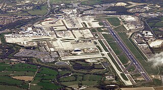
Gatwick Airport, also known as London Gatwick, is a major international airport near Crawley, West Sussex, England, 29.5 miles (47.5 km) south of Central London. In 2022, Gatwick was the second-busiest airport by total passenger traffic in the UK, after Heathrow Airport, and was the 8th-busiest in Europe by total passenger traffic. It covers a total area of 674 hectares.

Crawley is a large town and borough in West Sussex, England. It is 28 miles (45 km) south of London, 18 miles (29 km) north of Brighton and Hove, and 32 miles (51 km) north-east of the county town of Chichester. Crawley covers an area of 17.36 square miles (44.96 km2) and had a population of 106,597 at the time of the 2011 Census.

Fastway is a bus rapid transit network in Surrey and West Sussex, United Kingdom, linking Crawley with Gatwick Airport and Horley, the first to be constructed outside a major city. It uses specially adapted buses that can either be steered by the driver or operate as "self steering" guided buses along a specially constructed track. Fastway is operated by Metrobus, using Scania OmniCity, Wright StreetLite and Volvo B7RLE / Wright Eclipse 2 buses.

Northgate is one of the 14 residential neighbourhoods in Crawley, a town and borough in West Sussex, England. Crawley was planned and laid out as a New Town after the Second World War, based on the principle of self-contained neighbourhoods surrounding a town centre of civic and commercial buildings. Northgate was one of the four in the "inner ring" closest to the town centre, and was the second to be completed: almost all building work on the 168-acre (68 ha) site took place in the first half of the 1950s.

Horley is a town in the borough of Reigate and Banstead in Surrey, England, south of the towns of Reigate and Redhill. The county border with West Sussex is to the south with Crawley and Gatwick Airport close to the town.

Charlwood is a village and civil parish in the Mole Valley district of Surrey, England. It is immediately northwest of London Gatwick Airport in West Sussex, close west of Horley and north of Crawley. The historic county boundary between Surrey and Sussex ran to the south of Gatwick Airport. Boundaries were reformed in 1974 so that the county boundary between Surrey and West Sussex, delineated by the Sussex Border Path, now runs along the northern perimeter of the airport, and the southern extent of Charlwood.

The Charlwood and Horley Act 1974 was an Act of the Parliament of the United Kingdom that amended the Local Government Act 1972 to move the village of Charlwood and the town of Horley from West Sussex to Surrey.

As of 2011 there were 102 listed buildings and structures in the English borough of Crawley, West Sussex. Two others have subsequently gained listed status. The Borough of Crawley is based on the town of the same name, located approximately halfway between London and Brighton. Although Crawley expanded substantially after World War II when it was designated a New Town by an Act of Parliament, many older buildings remain.
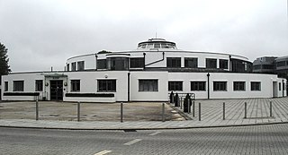
The Beehive is the original terminal building at Gatwick Airport, England. Opened in 1936, it became obsolete in the 1950s as the airport expanded. In 2008, it was converted into serviced offices, operated by Orega, having served as the headquarters of franchised airline GB Airways for some years before that. It was the world's first fully integrated airport building, and is considered a nationally and internationally important example of airport terminal design. The Beehive is a part of the City Place Gatwick office complex. The 20,000-square-foot (1,900 m2) former terminal building is on a 2-acre (0.81 ha) site.

St Michael and All Angels Church is a church in Lowfield Heath, a depopulated former village in the Borough of Crawley, West Sussex, England. Built by the Gothic Revival architect William Burges in 1867 to serve the village, it declined in importance as Lowfield Heath was gradually appropriated for the expansion of London Gatwick Airport and of its related development. The last Anglican service was held there in 2004, but the church reopened in 2008 as a Seventh-day Adventist place of worship. The building has Grade II* listed status, which identifies it as a "particularly important building of more than special interest" and of national importance. It is also the only building remaining in the former village from the era before the airport existed: every other structure was demolished, and the church now stands among warehouses, depots and light industrial units.

Lowfield Heath is a former village within the boundaries of the Borough of Crawley, West Sussex, England. Situated on the main London to Brighton road approximately 27 miles (43 km) south of London and 2 miles (3.2 km) north of Crawley, it was gradually rendered uninhabitable by the expansion of London Gatwick Airport immediately to the north.

Henry Edward Millar Smith is an English Conservative Party politician. He was Leader of West Sussex County Council from 2003 to 2010. He is the Member of Parliament (MP) for Crawley, having been first elected in the 2010 general election.

Tinsley Green is an area in the Borough of Crawley, one of seven local government districts in the English county of West Sussex. Originally a hamlet in the parish of Worth, it was absorbed by the New Town of Crawley in the 1940s and became part of the Pound Hill neighbourhood. As well as houses, farms and woodland, it became the site of the 1930s aerodrome at Gatwick—now London Gatwick Airport. The airport's first railway station was briefly known as Tinsley Green. The game of marbles has a strong local tradition, and Tinsley Green's pub hosts the British and World Marbles Championship each year.
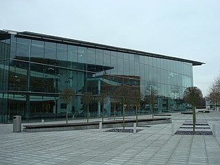
City Place Gatwick is an office complex located on the property of London Gatwick Airport in Crawley, West Sussex, England. The complex includes four buildings: The Beehive, an approximately 20,000-square-foot (1,900 m2) former terminal building at Gatwick Airport located on a 2.0-acre (0.81 ha) site; 1 City Place a 131,500-square-foot (12,220 m2) facility on a 4.2-acre (1.7 ha) site, 2 City Place, a 85,000-square-foot (7,900 m2) building on a 1.9 acres (0.77 ha) plot, and 3 City Place, a 65,000-square-foot (6,000 m2) building on a 1.06-acre (0.43 ha) plot. Hamiltons Architects designed the "L" shaped 3 City Place.

Fernhill is a hamlet close to Gatwick Airport in West Sussex, England. Its fields and farmhouses formerly straddled the county boundary between Surrey and West Sussex, but since 1990 the whole area has been part of the county of West Sussex and the borough of Crawley. Fernhill is bounded on three sides by motorways and the airport. A fatal aeroplane crash occurred here in 1969.

Crawley, a postwar New Town and borough in the English county of West Sussex, has a wide range of public services funded by national government, West Sussex County Council, Crawley Borough Council and other public-sector bodies. Revenue to fund these services comes principally from Council Tax. Some of Crawley's utilities and infrastructure are provided by outside parties, such as utility companies and West Sussex County Council, rather than by the borough council. To help pay for improved infrastructure and service provision in proposed major residential developments such as Kilnwood Vale and the North East Sector, the borough council has stated that as part of the Crawley Local Plan it would require developers to pay a Community Infrastructure Levy.
The expansion of Gatwick Airport has involved several proposals aimed at increasing airport capacity in south east England and relieving congestion at the main hub airport Heathrow.

Forge Wood is the 14th residential neighbourhood in Crawley, a town and borough in West Sussex. The 1,900 houses and other facilities will be built on open land in the northeast of the borough, adjoining the ancient village of Tinsley Green and to the north of the Pound Hill neighbourhood.
Gatwick Airport was in Surrey until 1974, when it became part of West Sussex as a result of a county boundary change. The original, pre-World War II airport was built on the site of a manor in the parish of Charlwood. The land was first used as an aerodrome in the 1920s, and in 1933 commercial flights there were approved by the Air Ministry.
