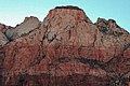
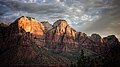
The geology of the Zion and Kolob canyons area includes nine known exposed formations, all visible in Zion National Park in the U.S. state of Utah. Together, these formations represent about 150 million years of mostly Mesozoic-aged sedimentation in that part of North America. Part of a super-sequence of rock units called the Grand Staircase, the formations exposed in the Zion and Kolob area were deposited in several different environments that range from the warm shallow seas of the Kaibab and Moenkopi formations, streams and lakes of the Chinle, Moenave, and Kayenta formations to the large deserts of the Navajo and Temple Cap formations and dry near shore environments of the Carmel Formation.

The Court of the Patriarchs' is a sandstone cliff on the south face of the Three Patriarchs in Zion Canyon in Zion National Park in Washington County, Utah, United States.

Bee Hive is a 6,904 feet (2,104 m) Navajo Sandstone mountain in Zion National Park in Washington County, Utah, United States, that is part of the Towers of the Virgin.

Mount Spry is a small 5,720-ft elevation mountain summit made of Navajo Sandstone located in Zion National Park, in Washington County of southwest Utah, United States. Officially named in 1934, it honors William Spry (1864-1929), the third governor of Utah. The nearest higher peak is The East Temple, 0.34 miles (0.55 km) to the east. Precipitation runoff from the mountain drains into tributaries of the North Fork Virgin River.

The Watchman is a 6,545-foot (1,995 m) sandstone mountain summit located in Zion National Park, in Washington County of southwest Utah, United States.

Mount Moroni is a 5,690-foot (1,730 m) elevation Navajo Sandstone summit located at the Court of the Patriarchs in Zion National Park, in Washington County of southwest Utah, United States.

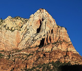
Cathedral Mountain is a 6,930-foot (2,110 m) elevation Navajo Sandstone summit located in Zion National Park, in Washington County of southwest Utah, United States.

Altar of Sacrifice is a 7,505-foot (2,288 m) Navajo Sandstone mountain in Zion National Park in Washington County, Utah, United States, that is part of the Towers of the Virgin.

Mountain of the Sun is a 6,722-foot (2,049 m) elevation Navajo Sandstone summit located in Zion National Park, in Washington County of southwest Utah, United States. Mountain of the Sun is situated immediately east of Court of the Patriarchs, and south of Zion Lodge, towering 2,500-feet above the lodge and the floor of Zion Canyon. It is set on the east side of the North Fork of the Virgin River which drains precipitation runoff from this mountain. Its neighbors include The Sentinel, Mount Spry, The East Temple, and Mount Moroni. This feature's name was officially adopted in 1934 by the U.S. Board on Geographic Names.
Lady Mountain is a 6,945-foot (2,117 m) elevation Navajo Sandstone summit located in Zion National Park, in Washington County of southwest Utah, United States.
Red Arch Mountain is a 5,930-foot (1,810 m) elevation Navajo Sandstone summit located in Zion National Park, in Washington County of southwest Utah, United States.

Twin Brothers is a 6,863-foot (2,092 m) Navajo Sandstone mountain in Zion National Park in Washington County, Utah, United States.
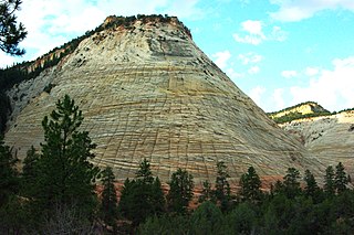
Checkerboard Mesa is an iconic 6,520+ ft elevation Navajo Sandstone summit located in Zion National Park, in Kane County of southwest Utah, United States. Checkerboard Mesa is situated immediately southwest of the park's east entrance, towering 900-feet above the Zion – Mount Carmel Highway. Its nearest neighbor is Crazy Quilt Mesa, one-half mile immediately west, and separated by Checkerboard Mesa Canyon. This canyon holds pools of rainwater which provide a vital source of water for resident bighorn sheep. This feature's name was officially adopted in 1935 by the U.S. Board on Geographic Names. The descriptive name stems from the cliff's distinctive multitudinous check lines in cross-bedded white sandstone which give the impression of a checkerboard. The horizontal lines are caused by cross-bedding, a remnant of ancient sand dunes. The vertical and sub-vertical lines formed by the contraction and expansion of the sandstone caused by temperature changes, freezing and thawing cycles, in combination with wetting and drying. This peak was originally named Checkerboard Mountain by the park's third superintendent, Preston P. Patraw. Precipitation runoff from this mountain drains into tributaries of the Virgin River.

The Sundial is a 7,590-foot elevation white Navajo Sandstone summit located in Zion National Park, in Washington County of southwest Utah, United States.

Meridian Tower is a 7,340-foot (2,240 m) Navajo Sandstone mountain in Zion National Park in Washington County, Utah, United States, that is part of the Towers of the Virgin

Three Marys are three sandstone pillars in Zion National Park in Washington County, Utah, United States.

The Witch Head is a 7,340-foot (2,240 m) white Navajo Sandstone mountain in Zion National Park in Washington County, Utah, United States, that is part of the Towers of the Virgin.
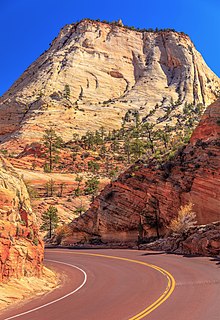
Crazy Quilt Mesa is a 6,760 ft (2,060 m) elevation white Navajo Sandstone summit located in Zion National Park, in Kane County of southwest Utah, United States.

The Three Patriarchs is a set of three sandstone monoliths on the west side of Zion Canyon in Zion National Park in Washington County, Utah, United States. The three main peaks were named by Frederick Fisher in 1916 for the biblical figures Abraham, Isaac and Jacob. The Court of the Patriarchs is the cliff that runs along the south face of the Three Partiarchs.

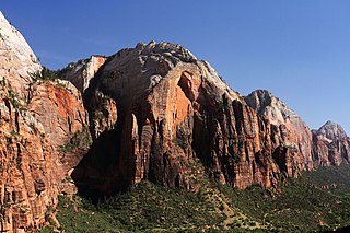
The Towers of the Virgin is a series of several lofty sandstone monoliths on the west side of Zion Canyon in Zion National Park in Washington County, Utah, United States.