Mummy Mountain is a high mountain summit in the Mummy Range of the Rocky Mountains of North America. The 13,430-foot (4,093 m) thirteener is located in the Rocky Mountain National Park, 8.5 miles (13.7 km) northwest by north of the Town of Estes Park in Larimer County, Colorado, United States.
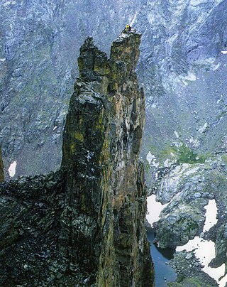
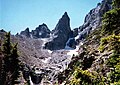
Petit Grepon is a semi-detached spire in Colorado's Rocky Mountain National Park. It is one of the "Cathedral Spires" which also includes: Sharkstooth, The Saber, and The Foil. The South Face route of Petit Grepon is described in the historic climbing text Fifty Classic Climbs of North America and considered a classic around the world.
Hallett Peak is a mountain summit in the northern Front Range of the Rocky Mountains of North America. The 12,720-foot (3,877 m) peak is located in the Rocky Mountain National Park Wilderness, 10.1 miles (16.2 km) southwest by west of the Town of Estes Park, Colorado, United States, on the Continental Divide between Grand and Larimer counties.

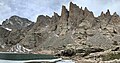
Sharkstooth Peak is a 12,468-foot-elevation (3,800-meter) mountain summit in Montezuma County, Colorado.
Fairchild Mountain is a high mountain summit in the Mummy Range of the Rocky Mountains of North America. The 13,508-foot (4,117 m) thirteener is located in the Rocky Mountain National Park Wilderness, 9.6 miles (15.5 km) northwest of the Town of Estes Park in Larimer County, Colorado, United States.

Mount Ida is a mountain summit in the northern Front Range of the Rocky Mountains of North America. The 12,874-foot (3,924 m) peak is located in the Rocky Mountain National Park Wilderness, 13.4 miles (21.6 km) west of the Town of Estes Park, Colorado, United States, on the Continental Divide between Grand and Larimer counties. The mountain was probably named after Mount Ida on Crete.

Chief Cheley Peak is a mountain summit in the northern Front Range of the Rocky Mountains of North America. The 12,815-foot (3,906 m) peak is located in the Rocky Mountain National Park Wilderness, 13.1 miles (21.1 km) west of the Town of Estes Park, Colorado, United States, on the Continental Divide between Grand and Larimer counties.

Powell Peak is a summit in Grand County, Colorado, in the United States. With an elevation of 13,176 feet (4,016 m), Powell Peak is the 493rd-highest summit in the state of Colorado.

Mount Chapin is a 12,454-foot-elevation (3,796-meter) mountain summit located in Rocky Mountain National Park, in Larimer County, of Colorado, United States. It is situated 11 miles west-northwest of the community of Estes Park, one mile east of Chapin Pass, and six miles east of the Continental Divide. Mount Chapin is part of the Mummy Range which is a subset of the Rocky Mountains. Topographic relief is significant as the south aspect rises 2,700 feet above Fall River in less than one mile. Neighbors include Mount Chiquita and Ypsilon Mountain to the immediate northeast, and the park's Alpine Visitor Center is three miles to the west.

Terra Tomah Mountain is a 12,718-foot-elevation (3,876-meter) mountain summit located in Rocky Mountain National Park, in Larimer County, of Colorado, United States. It is situated 13 miles west of the community of Estes Park, and 1.5 mile east of the Continental Divide. Terra Tomah Mountain is part of the Front Range which is a subset of the Rocky Mountains. Topographic relief is significant as the northeast aspect rises 3,300 feet above Forest Canyon in 1.5 mile. It is a prominent landmark viewed from Forest Canyon Overlook along the Trail Ridge Road.

Hayden Spire is a 12,480+ foot elevation (3,800 meter) pillar located in Rocky Mountain National Park, in Larimer County, Colorado, United States. It is situated 12 miles west of the community of Estes Park in Hayden Gorge, along a short spur on the Continental Divide. Hayden Spire is part of the Front Range which is a subset of the Rocky Mountains. It is the highest tower in a cluster of spires which can be viewed from Forest Canyon Overlook along the Trail Ridge Road. Topographic relief is significant as the north aspect rises 2,100 feet above Hayden Gulch in one-half mile. Neighbors include Terra Tomah Mountain two miles to the north, and Mount Julian 1.8 mile to the northwest.
Mount Cirrus is a 12,808-foot-elevation (3,904-meter) mountain summit in Colorado, United States.

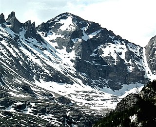
Chiefs Head Peak is a 13,577-foot-elevation (4,138-meter) mountain summit in Boulder County, Colorado, United States.

Otis Peak is a 12,486-foot-elevation (3,806-meter) mountain summit on the boundary shared by Grand County and Larimer County, in Colorado, United States.

McHenrys Peak is a 13,327-foot-elevation (4,062-meter) mountain summit on the boundary shared by Grand County and Larimer County in Colorado, United States.
Pagoda Mountain is a 13,497-foot-elevation (4,114-meter) mountain summit in Boulder County, Colorado, United States.

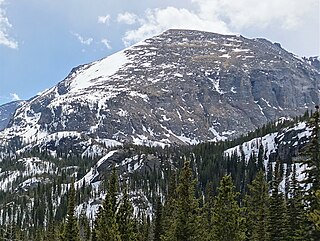
Stones Peak is a 12,922-foot-elevation (3,939-meter) mountain summit located in Larimer County, Colorado. It is situated in Rocky Mountain National Park, one mile east of the Continental Divide and 11.5 miles (18.5 km) west of the community of Estes Park. Stones Peak is part of the Front Range which is a subrange of the Rocky Mountains. Precipitation runoff from the mountain drains into tributaries of the Big Thompson River. Topographic relief is significant as the summit rises over 3,900 feet above the Big Thompson River in Forest Canyon in two miles. The peak is a prominent landmark viewed from Forest Canyon Overlook along the Trail Ridge Road.

Sprague Mountain is a 12,713-foot-elevation (3,875-meter) mountain summit on the boundary shared by Grand County and Larimer County, in Colorado, United States. It is set on the Continental Divide in the Front Range of the Rocky Mountains, and 12.5 miles (20.1 km) west of the community of Estes Park. Precipitation runoff from the mountain's east side drains into tributaries of the Big Thompson River and the west slope drains into headwaters of Tonahutu Creek which flows to Grand Lake. Topographic relief is significant as the summit rises over 1,900 feet above Tonahutu Creek in one mile. The peak is visible from Trail Ridge Road.
Thatchtop is a 12,668-foot-elevation (3,861-meter) mountain summit in Larimer County, Colorado, United States.

Sawtooth Mountain is a 12,304-foot (3,750 m) summit on the boundary shared by Boulder County and Grand County, in Colorado, United States.