Thorne, South Yorkshire

Last updated

Thorne
Town and civil parish
Thorne, Finkle Street - geograph.org.uk - 93485.jpg
Thorne town centre
Location map United Kingdom Borough of Doncaster.svg
Red pog.svg
Thorne
Location within the Borough of Doncaster
South Yorkshire UK location map.svg
Red pog.svg
Thorne
Location within South Yorkshire
Area18.15 sq mi (47.0 km2)
Population17,295 (2011 census)
  Density 953/sq mi (368/km2)
OS grid reference SE687132
Civil parish
  • Thorne
Metropolitan borough
Metropolitan county
Region
Country England
Sovereign state United Kingdom
Post town Doncaster
Postcode district DN8
Dialling code 01405
Police South Yorkshire
Fire South Yorkshire
Ambulance Yorkshire
UK Parliament
List of places
UK
England
Yorkshire
53°36′30″N0°57′30″W / 53.6083°N 0.9583°W / 53.6083; -0.9583

Thorne is a market town and civil parish in the City of Doncaster in South Yorkshire, England. It was historically part of the West Riding of Yorkshire until 1974. It has a population of 16,592, [1] increasing to 17,295 at the 2011 Census. [2]

Contents

History

The land which is now Thorne was once inhabited by Neolithic, Bronze Age and Iron Age people. It became a permanent settlement around AD 700, and is mentioned in the Domesday Book . The main industries in the town have traditionally been coal mining and farming.[ citation needed ]

Geography

Thorne lies east of the River Don, on the Stainforth and Keadby Canal, and is located at approximately 53°36′30″N0°57′30″W / 53.60833°N 0.95833°W / 53.60833; -0.95833 , at an elevation of around 16 feet (5 metres) above sea level, on the Yorkshire side of the border with Lincolnshire. The civil parish of Thorne and Moorends includes the village of Moorends to the north, and the Thorne Waste (also known as Thorne Moors) section of the Thorne Moors collective of moorland to the north-east. [3] [4] A small part of the edge of Thorne Waste, named "the Yorkshire Triangle", currently falls under North Lincolnshire, by technicality splitting this suburb of the civil parish between South Yorkshire and Lincolnshire. [5]

Culture and community

The Windmill at Thorne, by F. W. Jackson, 1911. F.W.Jackson windmill Thorne 1911.jpg
The Windmill at Thorne, by F. W. Jackson, 1911.

Thorne Memorial Park is the location for the Thorne Memorial Park Miniature Railway and the annual Thorne Festival. During the summer months, free brass band concerts are held at the park's bandstand.

Thorne Community Wood is a community woodland created from agricultural land by Thorne-Moorends Town Council, and The Peatlands Way, a circuitous walk around the wildlife areas of Thorne and Hatfield Moors, passes to the north of the town. [6]

Thorne's Farmers' Market is a monthly event.

For many decades in the twentieth century Thorne Colliery was a central focus of employment within the town, although its history was very troubled.

In recent years, employment opportunities have been increasing, most notably since the opening of Nimbus Park on the outskirts of the town, where The Range have operated a major distribution centre since 2012. [7]

Landmarks

St Nicholas Church St Nicholas Church, Thorne - geograph.org.uk - 450589.jpg
St Nicholas Church

Notable buildings in the town include the parish church and Peel Hill Castle. The parish church consists of material from the 12th to 15th centuries with some later additions and repairs. It is a grade I listed structure, [8] and is dedicated to St Nicholas. Peel Hill Castle is the earthwork remains of a Norman motte built by the de Warenne family.

The Old Darley Brewery Thorne, The Old Darley Brewery. - geograph.org.uk - 89350.jpg
The Old Darley Brewery

Although no structure remains, the foundations indicate that it had a circular keep. It might have been used as a hunting lodge, connected with Hatfield Chase, and prisoners were kept in its tower in the 16th century. It was demolished in the 17th century. [6] The monument is in the care of Thorne-Moorends Town Council.[ citation needed ] There are Dutch-like[ clarification needed ] bridges over local canals, such as the Wykewell bridge. There is one remaining water tower, located on South End. Another water tower used to stand on Field Road, but was demolished in 2013. The subsequent empty land was, in 2015, earmarked as the planned location for a new Lidl supermarket. Nearby are the extensive Thorne Moors.

Transport

The Marina Staniland Marina - geograph.org.uk - 524762.jpg
The Marina

The town is served by two railway stations: Thorne North, and Thorne South; as well as Junction 6 of the M18 and junction 1 of the M180.

The town is served by four bus services, all of which are operated by First South Yorkshire. The services include the 87/87a towards Doncaster and Moorends, the 84 towards Doncaster, the 87b towards Doncaster and Moorends, and the 86 service. The latter is a local route only connecting both Thorne and Moorends with the newly built retail park. The 8/8a and 86 services only operate on weekdays and Saturdays. The 84 service operates on evenings only Monday to Saturday, and throughout the day hourly on a Sunday, this is due to there being no 87b service on a Sunday.

The A614 runs through the town, crossing the canal.

Education

In September 2005 a newly built school, Trinity Academy, opened in Thorne, specialising in Business and Enterprise. The £24 million state-of-the-art Academy has nine classes per year group, had an initial school population of 1250 children between the ages of 11 and 18, and is the third Christian Ethos school founded by Sir Peter Vardy. In 2004, 21% of students from Thorne and Moorends achieved five or more passes at grade C or above. Trinity was named as England's most improved academy in 2007, for which they were presented with an award by Sir Bruce Liddington, the Schools Commissioner in England and Wales, at a conference held in London run by the Specialist Schools and Academies Trust. [9]

The academy replaced Thorne Grammar School, whose notable alumni were the opera singer Lesley Garrett; George Porter, a nobel prize-winning chemist; Charles Spencer, pianist; and Sir Graham Hall, former CEO of Yorkshire Electricity.

Media

Local news and television programmes are provided by BBC Yorkshire and ITV Yorkshire. Television signals are received from the Emley Moor TV transmitter. [10]

Local radio stations are BBC Radio Sheffield, Heart Yorkshire, Capital Yorkshire, Hallam FM, Greatest Hits Radio South Yorkshire, TX1 Radio and its own Community Radio station, TMCR 95.3. [11]

The town is served by the local newspaper, Thorne Times. [12]

Sport

Thorne's rugby league side, Moorends-Thorne Marauders RLFC, play in the CMS Yorkshire league during the winter season and the Rugby League Conference during the summer.

The rugby union side, Thornensians RUFC currently play in Yorkshire Division 3 and have won the Yorkshire Cup on 2 occasions along with the South Yorkshire trophy on a record 12 occasions- the most recent in the 2014/15 season. Their home ground is Coulman Road and big games can attract crowds above 300.

Football is played by the Moorends Hornets and Stingers Junior Football Club.

Speedway racing, earlier known as Dirt track racing, was staged at a track on the southern edge of the town in 1930. Billed as "The Wembley of the North" the track followed the edge of the football pitch on the inside of the track. Rather than two sweeping bends, the track is shown on contemporary ordnance survey maps as having four corners and four straights.

The Sea Cadet unit in Thorne, TS Gambia, offers watersports and other activities to young people within the town.

Notable people

See also

Related Research Articles

<span class="mw-page-title-main">Lincolnshire</span> County of England

Lincolnshire is a ceremonial county in the East Midlands and Yorkshire and the Humber regions of England. It is bordered by the East Riding of Yorkshire across the Humber estuary to the north, the North Sea to the east, Norfolk, Cambridgeshire, Northamptonshire and Rutland to the south, and Leicestershire, Nottinghamshire and South Yorkshire to the west. The county town is the city of Lincoln.

<span class="mw-page-title-main">Meltham</span> Town and civil parish in West Yorkshire, England

Meltham is a town and civil parish within the Metropolitan Borough of Kirklees, in West Yorkshire, England. It lies in the Holme Valley, below Wessenden Moor, 5 miles south-west of Huddersfield on the edge of the Peak District National Park. It had a population of 8,089 at the 2001 census, which was estimated to have increased to 8,600 by 2005. The population assessed at the 2011 Census was 8,534. It has 12 elected council members who meet up around every 6 weeks.

<span class="mw-page-title-main">Epworth, Lincolnshire</span> Town and civil parish in Lincolnshire, England

Epworth is a town and civil parish on the Isle of Axholme, in the North Lincolnshire unitary authority of Lincolnshire, England. The town lies on the A161, about halfway between Goole and Gainsborough. As the birthplace of John Wesley and Charles Wesley, it has given its name to many institutions associated with Methodism. Their father, Samuel Wesley, was the rector from 1695 to 1735.

<span class="mw-page-title-main">Crowle, Lincolnshire</span> Town in North Lincolnshire, England

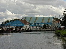
Crowle is a market town in the civil parish of Crowle and Ealand, on the Isle of Axholme in the North Lincolnshire unitary authority of Lincolnshire, England. The civil parish had a population at the 2011 census of 4,828. The town lies on the Stainforth and Keadby Canal.

<span class="mw-page-title-main">City of Doncaster</span> Metropolitan borough in England

The City of Doncaster is a metropolitan borough with city status in South Yorkshire, England. It is named after its principal settlement, Doncaster, and includes the surrounding suburbs of Doncaster as well as numerous towns and villages. The district has large amounts of countryside; at 219 square miles (570 km2), it is the largest metropolitan borough in England by area.

<span class="mw-page-title-main">Hatfield, South Yorkshire</span> Town and civil parish in South Yorkshire, England

Hatfield is a town and civil parish in the City of Doncaster in South Yorkshire, England. It had a population of 17,236 at the 2011 Census. The town is located on the A18 road between Doncaster and Scunthorpe, and to the west of the M18 motorway. It shares a railway station with Stainforth on the line between Goole and Scunthorpe, and Doncaster. Recorded history in the parish extends as far back as 730, when Bede wrote about the Northumbrian King, Edwin, being killed in battle in the area.

<span class="mw-page-title-main">Moorends</span> Village in South Yorkshire, England

Moorends is a village in the north-east of the City of Doncaster, South Yorkshire, England, situated on the border with East Yorkshire and Lincolnshire. It was historically part of the West Riding of Yorkshire until 1974. It is part of the civil parish of Thorne, which lies to the south.

<span class="mw-page-title-main">Maltby, South Yorkshire</span> Town and civil parish in South Yorkshire, England

Maltby is a former mining town and civil parish in the Metropolitan Borough of Rotherham, South Yorkshire, England. It was historically in the West Riding of Yorkshire. It is located 6 miles (10 km) east of Rotherham and 10 miles (16 km) north-east of Sheffield. It forms a continuous urban area with Hellaby, separated from the rest of Rotherham by the M18 motorway. It had a population of 16,688 at the 2011 Census.

<span class="mw-page-title-main">Isle of Axholme</span> Region on the border of Lincolnshire and Yorkshire in England

The Isle of Axholme is a geographical area in England: a part of North Lincolnshire that adjoins South Yorkshire. It is located between the towns of Scunthorpe and Gainsborough, both of which are in the traditional West Riding of Lindsey, and Doncaster.

<span class="mw-page-title-main">Don Valley (UK Parliament constituency)</span> Parliamentary constituency in the United Kingdom since 1918

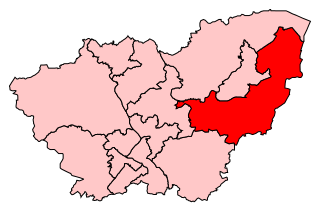
Don Valley is a constituency in South Yorkshire represented in the House of Commons of the UK Parliament since 2019 by Nick Fletcher of the Conservative Party.

TMCR or Today's More Choice Radio is a community radio station based in Thorne, South Yorkshire, England, broadcasting to north-east Doncaster and parts of the Isle of Axholme in Lincolnshire.

<span class="mw-page-title-main">North Hykeham</span> Town in North Kesteven, Lincolnshire, England

North Hykeham is a town and civil parish in the North Kesteven district, in the county of Lincolnshire, England. It forms part of the Lincoln Urban Area. The population of the town at the 2011 census was 13,884.

Moorends-Thorne Marauders RLFC is a rugby league club based in Thorne, Doncaster, South Yorkshire.

<span class="mw-page-title-main">Kirton in Lindsey</span> Town and civil parish in the North Lincolnshire district, of Lincolnshire, England

Kirton in Lindsey, also abbreviated to Kirton Lindsey, is a market town and civil parish in North Lincolnshire, England. It is 7 miles (11 km) south-east from Scunthorpe.

<span class="mw-page-title-main">Snaith</span> Town in the East Riding of Yorkshire, England

Snaith is a market town in the East Riding of Yorkshire, England, close to the River Aire and the M62 and M18 motorways, 7 miles (11 km) west of Goole, 10 miles (16 km) east of Knottingley, 8 miles (13 km) south of Selby, 10 miles (16 km) southwest of Howden and 8 miles (13 km) northwest of Thorne.

<span class="mw-page-title-main">Thorne and Hatfield Moors</span> Lowland raised peat bog in England

Thorne and Hatfield Moors form the largest area of lowland raised peat bog in the United Kingdom. They are situated in South Yorkshire, to the north-east and east of Doncaster near the town of Thorne, and are part of Hatfield Chase. They had been used for small-scale extraction of peat for fuel from medieval times, and probably much earlier, but commercial extraction of the peat for animal bedding began in the 1880s. The peat was cut on the moors and, once it had dried, transported to several works on 3 ft narrow gauge tramways, always called trams locally. The wagons were pulled by horses to works at Creyke's Siding, Moorends, Medge Hall, Swinefleet and Hatfield. There was also a network of canals supplying the Moorends Works.

<span class="mw-page-title-main">Thorne and Hatfield Moors Peat Canals</span>

Thorne and Hatfield Moors Peat Canals were a series of canals in South Yorkshire and Lincolnshire, England, which were used to carry cut peat from Thorne and Hatfield Moors to points where it could be processed or exported. There were two phases to the canals, the first of which lasted from the 1630s until the 1830s when coal imported on the Stainforth and Keadby Canal reduced the demand for peat as a fuel. The second started in the 1890s when peat found a new use as bedding for working horses and lasted until 1922 when Moorends Mill which processed the peat was destroyed by fire.

William Bunting was an amateur naturalist and eco-warrior who is credited with saving the wildlife habitat of Thorne Moors from the planned dumping of 32 million tons of fuel-ash, peat-cutting and drainage, and for campaigning for the reinstatement of public footpaths on maps of the same Moors.

<span class="mw-page-title-main">Crowle Peatland Railway</span>

Crowle Peatland Railway is a fledgling railway museum based on the peat moors at Crowle in North Lincolnshire, England.

References

  1. Office for National Statistics : Census 2001 : Parish Headcounts : Doncaster Retrieved 27 August 2009
  2. "Town population 2011". Neighbourhood Statistics. Office for National Statistics. Retrieved 8 March 2016.
  3. UK Census (2011). "Local Area Report – Thorne Parish (E04000095)". Nomis. Office for National Statistics . Retrieved 12 November 2019.
  4. "Humberhead Peatlands - Map of Thorne Moors (Including Thorne Waste Boundaries)". Humberhead Peatlands Official Website. Retrieved 12 November 2019.
  5. "2006 Thorne Moors Vertebrate Report – "Thorne Waste (except now the Yorkshire Triangle) lies in South Yorkshire, and the other parishes lie in East Yorkshire, except Crowle Moor and the Yorkshire Triangle, which are in North Lincolnshire". birdingsiteguide.com. Retrieved 4 November 2021.
  6. 1 2 "Thorne-Moorends Town Council: The Peatlands Way 50 Challenge Walk Archived 26 June 2012 at the Wayback Machine ; Thorne-moorends.gov.uk. Retrieved 28 April 2012
  7. "The Range seals huge distribution centre deal". Insider Media Ltd. Retrieved 6 September 2017.
  8. Historic England. "Church of St Nicholas, Thorne (1193076)". National Heritage List for England . Retrieved 7 April 2012.
  9. "Trinity – Most Improved GCSEs". Emmanuel Schools Foundation. Archived from the original on 19 October 2013. Retrieved 7 April 2012.
  10. "Emley Moor (Kirklees, England) Full Freeview transmitter". UK Free TV. 1 May 2004. Retrieved 11 October 2023.
  11. "TMCR 95.3" . Retrieved 11 October 2023.
  12. "Thorne Times" . Retrieved 11 October 2023.
  13. McConnell, Anita (27 May 2010). "Crapper, Thomas". Oxford Dictionary of National Biography (online ed.). Oxford University Press. doi:10.1093/ref:odnb/55389.(Subscription or UK public library membership required.)
  14. "William Pool". Humber Packet Boats. Retrieved 14 November 2015.

Commons-logo.svg Media related to Thorne at Wikimedia Commons