Related Research Articles

A biome is a biogeographical unit consisting of a biological community that has formed in response to the physical environment in which they are found and a shared regional climate. Biomes may span more than one continent. Biome is a broader term than habitat and can comprise a variety of habitats.

The Republic of Colombia is situated largely in the north-west of South America, with some territories falling within the boundaries of Central America. It is bordered to the north-west by Panama; to the east by Brazil and Venezuela; to the south by Ecuador and Peru; and it shares maritime limits with Costa Rica, Nicaragua, Honduras, Jamaica, the Dominican Republic, and Haiti.

Eritrea is located in the Horn of Africa and is bordered on the northeast and east by the Red Sea, on the west and northwest by Sudan, on the south by Ethiopia, and on the southeast by Djibouti. The country has a high central plateau that varies from 1,800 to 3,000 meters (5,906–9,843 ft) above sea level. A coastal plain, western lowlands, and some 350 islands comprise the remainder of Eritrea's land mass.
Tierra caliente is an informal term used in Latin America to refer to places with a distinctly tropical climate. These are usually regions from sea level from 0–3,000 feet. The Peruvian geographer Javier Pulgar Vidal used the altitude of 1,000 m as the border between the tropical rain forest and the subtropical cloud forest.

In Latin America, tierra fría are mountain locations where high elevation results in a markedly cooler climate than that encountered in the lowlands at a comparable latitude. The combination of low latitude and high altitude — typically between approximately 2,000 m and 3,500 m in locations within 10° of the equator — produces a climate that falls into the same category as many oceanic climates found along the west coasts of the continents within the temperate zones — mild temperatures all year round, with monthly averages ranging from about 10°C (50°F) in the coldest months to about 18°C (64.4°F) in the warmest months. Common crops grown in the tierra fría are potatoes, wheat, barley, oats, corn, and rye.
Tierra Helada, also known as Tierra Nevada, is a term used in Latin America to refer to the highest places found within the Andes mountains.

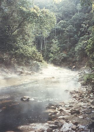
The Yungas is a bioregion of a narrow band of forest along the eastern slope of the Andes Mountains from Peru and Bolivia, and extends into Northwest Argentina at the slope of the Andes pre-cordillera. It is a transitional zone between the Andean highlands and the eastern forests. Like the surrounding areas, the Yungas belong to the Neotropical realm; the climate is rainy, humid, and warm.
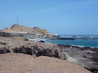
The Chala or "Coast" is one of the eight natural regions in Peru. It is formed by all the western lands that arise from sea level up to the height of 500 meters. The coastal desert of Peru is largely devoid of vegetation but a unique fog and mist-fed ecosystem called Lomas is scattered among hills near the Pacific coast as elevations up to 1,000 metres (3,300 ft).

Quechua is one of the eight Natural Regions of Peru and is between 2,300 and 3,500 m above sea level. It is composed of big valleys divided by rivers fed by estival rains.

Suni or Jalca is one of the eight Natural Regions of Peru. It is located in the Andes at an altitude between 3,500 and 4,000 metres above sea level. Suni has a dry and cold weather and there are many glacial valleys.

Janca is one of the eight Natural Regions of Peru. It is located in the frozen heights where the condor lives.
Rupa-Rupa or High Jungle is one of the eight natural regions of Peru. It is located between 400 and 1,000 m above the sea level to the east of the Andes mountain range in the Amazon basin of Peru. This region has many long, narrow valleys and fluvial mountain trails. The weather is warm, humid, and rainy.
Omagua or low jungle is one of the eight natural regions of Peru. It is located between 80 and 400m above sea level in the Peruvian Amazonia. In this region, there are a lot of rivers that create meanders, swamps and lagoons.

When the Spanish arrived, they divided Peru into three main regions: the coastal region, that is bounded by the Pacific Ocean; the highlands, that is located on the Andean Heights, and the jungle, that is located on the Amazonian Jungle. But Javier Pulgar Vidal, a geographer who studied the biogeographic reality of the Peruvian territory for a long time, proposed the creation of eight Natural Regions. In 1941, he presented his thesis "Las Ocho Regiones Naturales del Perú" at the III General Assembly of the Pan-American Institute of Geography and History.

The Climate of Colombia is characterized for being tropical and isothermal as a result of its geographical location near the Equator presenting variations within five natural regions and depending on the altitude, temperature, humidity, winds and rainfall. Each region maintains an average temperature throughout the year only presenting variables determined by precipitation during a rainy season caused by the Intertropical Convergence Zone.
Altitudinal zonation in mountainous regions describes the natural layering of ecosystems that occurs at distinct elevations due to varying environmental conditions. Temperature, humidity, soil composition, and solar radiation are important factors in determining altitudinal zones, which consequently support different vegetation and animal species. Altitudinal zonation was first hypothesized by geographer Alexander von Humboldt who noticed that temperature drops with increasing elevation. Zonation also occurs in intertidal and marine environments, as well as on shorelines and in wetlands. Scientist C. Hart Merriam observed that changes in vegetation and animals in altitudinal zones map onto changes expected with increased latitude in his concept of life zones. Today, altitudinal zonation represents a core concept in mountain research.
The ecology of the Himalayas varies with climate, rainfall, altitude, and soils. The climate ranges from tropical at the base of the mountains to permanent ice and snow at the highest elevations. The amount of yearly rainfall increases from west to east along the southern front of the range. This diversity of climate, altitude, rainfall and soil conditions supports a variety of distinct plant and animal species, such as the Nepal gray langur

The Central American montane forests are an ecoregion of the tropical and subtropical moist broadleaf forests biome, as defined by the World Wildlife Fund, located in mountains of Central America.

Katon-Karagay National Park is the largest national park in Kazakhstan, located on the eastern edge of the country, in the Southern Altai Mountains. The park fills the west side of the "X" where the borders of Kazakhstan, Russia, China, and Mongolia meet. The highest peak in Siberia, is on the Russian border in the Katun Range. The park is in Katonkaragay District of East Kazakhstan Region, 1,000 kilometres (620 mi) southeast of the capital city of Astana.

The Mindanao montane rain forests ecoregion covers the montane forests - the zone between the lowland forest and the treeline - in the mountains on the island of Mindanao in the Philippines. Because the ecoregion covers only elevations above 1,000 metres (3,300 ft), it exists in seven discontinuous patches surrounded by lowland rainforest. Biodiversity is high, both because of the isolation of separate mountain ranges that have led to species variation within the island, and because of the altitude zonation. Because most of the surrounding lowland forest has been cleared for human use, the montane regions have become an important refuge for rare and endemic species.
References
- 1 2 3 "Altitude zones of Mexico". Geomexico. Retrieved 2019-03-09.
- ↑ Schütt, Brigitta (2005). "Azonale Böden und Hochgebirgsböden" (PDF) (in German). Archived from the original (PDF) on 2009-03-27.
- ↑ Zech, W; Hintermaier-Erhard, G (2002). Böden der Welt – Ein Bildatlas (in German). Heidelberg. p. 98.
- ↑ Christopher, Salter; Hobbs, Joseph; Wheeler, Jesse; Kostbade, J. Trenton (2005). Essentials of World Regional Geography (2nd ed.). New York: Harcourt Brace. pp. 464–465.
- ↑ "Middle America: Altitudinal Zonation". Archived from the original on 2009-07-24. Retrieved 2009-03-11.
- ↑ Pulgar Vidal, Javier (1941). "Las ocho regiones naturales del Perú". Boletín del Museo de historia natural "Javier Prado" (in Spanish). Lima. 17 (especial): 145–161.
- ↑ "Mexico". Encyclopedia Britannica. Retrieved 2019-03-07.