The Naches River is a tributary of the Yakima River in central Washington in the United States. Beginning as the Little Naches River, it is about 75 miles (121 km) long. After the confluence of the Little Naches and Bumping River the name becomes simply the Naches River. The Naches and its tributaries drain a portion of the eastern side of the Cascade Range, east of Mount Rainier and northeast of Mount Adams. In terms of discharge, the Naches River is the largest tributary of the Yakima River.

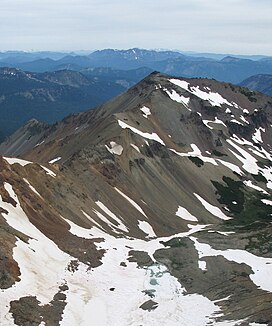
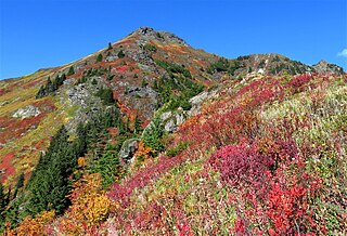
Ives Peak, elevation 7,920+ ft, is located in the Goat Rocks on the border of Lewis and Yakima Counties, in the U.S. state of Washington. Ives Peak is within the Goat Rocks Wilderness and the McCall Glacier on its eastern slopes. Additionally, the Pacific Crest National Scenic Trail is near the west slopes of the peak. Precipitation runoff from the peak's east slope drains to the Tieton River, whereas the west slope drains into the Cispus River. Ives Peak ranks as the fourth-highest peak in the Goat Rocks Wilderness.

Kendall Peak is a mountain located on the county line separating King County and Kittitas County of Washington state. It is within the Alpine Lakes Wilderness on the crest of the Cascade Range. Kendall Peak is situated two miles northeast of Snoqualmie Pass on land managed by Mount Baker-Snoqualmie National Forest. Precipitation runoff on the east side of the mountain drains into Silver Creek and makes its way to the Columbia River via Yakima River, whereas the west side of the mountain drains into the South Fork Snoqualmie River via Commonwealth Creek. The Pacific Crest Trail traverses its west flank and an exposed section of the trail called Kendall Katwalk has seen tragic deaths over the years, most recently September 5, 2018. The nearest higher peak is Red Mountain, 0.9 miles (1.4 km) to the north-northwest.

Del Campo Peak is a prominent summit near the western edge of the North Cascades, in Snohomish County of Washington state. It is located south of Barlow Pass along the Mountain Loop Highway near the Monte Cristo area. It is situated on land administered by the Mount Baker-Snoqualmie National Forest. The mountain is named for a mining claim on the mountain's slope. The nearest peak is Gothic Peak, 0.5 miles (0.80 km) to the southwest, and Foggy Pass is the low point between the two peaks. Foggy Lake lies in Gothic Basin below the south face of Del Campo Peak and collects precipitation runoff which ultimately drains to South Fork Sauk River via Weden Creek. Runoff from the west side of the mountain drains into the Sultan River, and the north side drains into headwaters of the Stillaguamish River. In terms of favorable weather, the best months for climbing are July through September.

Deadwood Peak is a 6,280-foot-elevation mountain summit located on the eastern border of Mount Rainier National Park. It is also situated on the shared border of Pierce County and Yakima County in Washington state. Deadwood Peak is set on the crest of the Cascade Range, immediately north of Yakima Peak and Chinook Pass, with the Pacific Crest Trail traversing its east slope. Its nearest higher peak is Naches Peak, 0.59 mi (0.95 km) to the southeast. Deadwood Peak takes its name from Deadwood Lakes and Deadwood Creek to its northwest, and their names came from the large number of downed trees in the area. From Chinook Pass, a short scramble up the south side leads to the summit with unobstructed views of Mount Rainier.
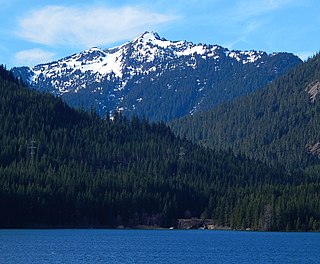
Silver Peak is a prominent 5,605 ft (1,710 m) mountain located in eastern King County of Washington state. It is set on the crest of the Cascade Range, on land managed by Mount Baker-Snoqualmie National Forest. Silver Peak is situated 4.5 miles southwest of Snoqualmie Pass, and three miles west of Keechelus Lake. The Pacific Crest Trail traverses its east flank and provides easiest access. The nearest higher neighbor is Granite Mountain, 3.98 miles (6.41 km) to the north-northwest. Precipitation runoff from the east side of the mountain drains into Cold Creek, a tributary of the Yakima River, whereas the west side of the mountain drains into the South Fork Snoqualmie River via Humpback Creek.
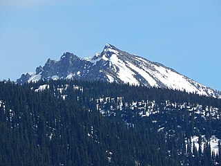
Mount Aix is a 7,766-foot (2,367 m) mountain summit in Yakima County of Washington state.
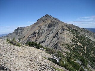
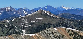
Bismarck Peak is a 7,585-foot-elevation mountain summit centrally located in the William O. Douglas Wilderness on land administered by the Wenatchee National Forest. It is also 24 miles east-southeast of Mount Rainier in Yakima County of Washington state. Bismarck Peak is situated east of the crest of the Cascade Range, southeast of Bumping Lake, south of Mount Aix, and northwest of Rimrock Lake. Its nearest higher peak is Mount Aix, 2.2 mi (3.5 km) to the north-northeast. Aix and Bismarck are the two highest peaks midway between Mount Rainier National Park and Yakima, Washington so they are quite prominent. Precipitation runoff from Bismarck Peak drains into tributaries of the Yakima River, thence into the Columbia River.

Four Brothers is a 6,485-foot-elevation (1,977-meter) mountain summit located in Kittitas County of Washington state.
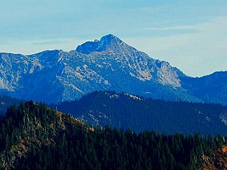
Yellow Aster Butte is a 6,241-foot (1,902-metre) Skagit Range summit located three miles south of the Canada–United States border, in Whatcom County of Washington state. It is situated within the Mount Baker Wilderness, on land managed by Mount Baker-Snoqualmie National Forest. The nearest higher neighbor is Winchester Mountain, 1.77 miles (2.85 km) to the east, and Mount Larrabee is set 2.3 miles (3.7 km) to the northeast. The summit offers views of Mount Larrabee, Tomyhoi Peak, American Border Peak, Canadian Border Peak, Mount Shuksan, and Mount Baker. Precipitation runoff on the north side of the mountain drains into Tomyhoi Creek, whereas the west side of the mountain drains into Damfino Creek, and the south slope is drained by Swamp Creek.

Minnie Peak is a 5,610-ft mountain summit located in Mount St. Helens National Volcanic Monument, in Gifford Pinchot National Forest, in Skamania County of southwest Washington state. It is situated in the Cascade Range, one mile northeast of Coldwater Lake, and 2.7 mi (4.3 km) west of Mount Whittier. Its nearest higher neighbor is Mount Venus, 1.67 mi (2.69 km) to the northeast, Coldwater Peak rises 2 mi (3.2 km) to the south, and Mount St. Helens is 9 mi (14 km) to the south. Although modest in elevation, relief is significant as the summit rises 3,000 feet above the Coldwater Creek valley in less than one mile. Precipitation runoff from Minnie Peak drains south into Coldwater Creek, or north into Miners Creek, both of which are part of the North Fork Toutle River drainage basin. This peak's name is derived from the Minnie mining claim nearby along Miners Creek. The primary minerals extracted there were silver and copper.
Hock Mountain is a 7,750-foot-elevation summit located in the Methow Mountains, a subset of the North Cascades in Washington state. It is situated on the triple-shared boundary of North Cascades National Park, Lake Chelan-Sawtooth Wilderness, and Lake Chelan National Recreation Area, as well as the shared border between Chelan County and Okanogan County. Additionally, it lies one mile southwest of Twisp Mountain, and 2.24 miles (3.60 km) due south of Stiletto Peak, the nearest higher neighbor. The north face is steep, granitic rock, but the west slope is more moderate, allowing a scramble ascent. Precipitation runoff from the north and west sides of Hock drains to the Stehekin River via Bridge Creek, whereas the south and east sides of the mountain drain into the South Fork Twisp River.

Le Conte Mountain is a 7,762-foot-elevation (2,366-meter) summit located on the shared boundary of Skagit County and Chelan County in Washington state. It is positioned on the crest of the North Cascades Range, and is set within the Glacier Peak Wilderness. Le Conte Mountain is situated on the shared border of Mount Baker-Snoqualmie National Forest and Okanogan-Wenatchee National Forest. Access to the peak is via the Ptarmigan Traverse. The nearest higher neighbor is Sentinel Peak, 1.87 miles (3.01 km) to the south-southeast, and Spider Mountain is 2.4 miles (3.9 km) to the northeast. The Le Conte Glacier and South Cascade Glacier lie to the south of the peak. Precipitation runoff on the east side the mountain drains into Flat Creek which is a tributary of the Stehekin River, while precipitation drains into headwaters of the South Fork Cascade River from the west side. Topographic relief is significant as the southwest aspect rises nearly 2,500 feet above South Cascade Lake in less than one-half mile, and the northeast aspect rises 3,200 feet above Flat Creek in one mile.

Painted Mountain is a 6,975-foot-elevation (2,126-meter) summit located in the North Cascades, in Snohomish County of Washington state. The mountain is situated in the Glacier Peak Wilderness on land managed by Mount Baker-Snoqualmie National Forest. Neighbors include line parent Black Mountain, 2.2 mi (3.5 km) to the east, and Glacier Peak is 7 mi (11 km) to the northeast. Precipitation runoff from the peak drains west into tributaries of the North Fork Sauk River. Topographic relief is significant as the summit rises nearly 5,000 feet above the river in less than two miles.

Tinkham Peak is a double summit mountain located on the common boundary of King County and Kittitas County in Washington state.
Mount Buckindy is a remote 7,320-foot-elevation (2,230-meter) mountain summit located in the North Cascades, in Skagit County of Washington state. It is the second-highest point of the Buckindy Range, or Buckindy Ridge. It is set in the Glacier Peak Wilderness on land managed by the Mount Baker-Snoqualmie National Forest. It is situated 20 miles east-northeast of Darrington, Washington, and 17 miles north-northwest of Glacier Peak which is one of the Cascade stratovolcanoes. Precipitation runoff from Mount Buckindy drains south to the Suiattle River via Buck Creek and Downey Creek, and north to the Cascade River via Kindy Creek. Topographic relief is significant as the summit rises 4,700 feet above Kindy Creek in less than two miles. The mountain's toponym is a portmanteau of Buck and Kindy Creeks, and has been officially adopted by the United States Board on Geographic Names.

French Cabin Mountain is a triple-peak mountain located in Kittitas County of Washington state. The highest summit is West Peak, elevation 5,724-feet, the South Peak is 5,560-feet-elevation, and the North Peak is 5,498-feet. French Cabin Mountain is situated six miles north of Easton, between Kachess Lake and Cle Elum Lake, on land managed by Okanogan-Wenatchee National Forest. Precipitation runoff from the mountain drains north into French Cabin Creek and south into Silver Creek, which are both part of the Yakima River drainage basin. Topographic relief is significant as the summit rises 1,700 feet above Silver Creek in one mile, and the east aspect rises 3,400 feet above Cle Elum Lake in one and a half miles (2.4 km). French Cabin Mountain is the toponym officially adopted by the U.S. Board on Geographic Names, however "Frenchman Mountain" is a variant. West Peak is also an official toponym.

Foggy Peak is a 6,810-foot-elevation (2,076-meter) mountain summit in Snohomish County of Washington state.
Tamarack Peak is a 7,290-foot (2,222-metre) mountain summit located on the border shared by Okanogan County and Whatcom County in Washington state.
Mount Bigelow is an 8,449-foot-elevation (2,575-meter) mountain summit located on the border shared by Okanogan and Chelan counties in Washington state.