
Longdendale is a valley in the Peak District of England, north of Glossop and southwest of Holmfirth. The name means "long wooded valley" and the valley is mostly in the counties of Derbyshire and Greater Manchester.

High Peak is a local government district with borough status in Derbyshire, England, covering a high moorland plateau in the Dark Peak area of the Peak District National Park. The district stretches from Holme Moss in the north to Sterndale Moor in the south, and from Hague Bar in the west to Bamford in the east. The population of the borough taken at the 2011 Census was 90,892. The borough is unusual in having two administrative centres for its council, High Peak Borough Council; the offices are in Buxton and Glossop. Other towns include Chapel-en-le-Frith, Hadfield, New Mills and Whaley Bridge.
Until 1974, Flintshire, also known as the County of Flint, was an administrative county in the north-east of Wales, later classed as one of the thirteen historic counties of Wales.

Wrexham Maelor was a local government district with borough status, being one of six districts in the county of Clwyd, north-east Wales, from 1974 to 1996.
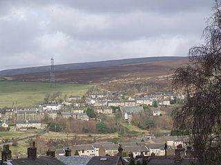
Tintwistle is a village and civil parish in the High Peak district of Derbyshire, England, which had a population of 1,400 at the 2011 census. The village is just north of Glossop at the lower end of Longdendale Valley. Tintwistle, like nearby Crowden and Woodhead, lies within the historic county boundaries of Cheshire.

Chester was a rural district of Cheshire, England, from 1894 to 1974. It was located near the city and county borough of Chester but did not include it. The district saw various boundary changes throughout its life. It included the small civil parish of Chester Castle, an exclave of the rural district within the boundaries of the county borough of Chester.
Bucklow Rural District was, from 1894 to 1974, a local government district in the north of the administrative county of Cheshire, England. Following the Local Government Act 1972, this rural district was split between the new Greater Manchester boroughs of Trafford and Manchester, and Macclesfield, which was retained in Cheshire.
Bury was a rural district in Lancashire, England from its establishment in 1894 under the Local Government Act 1894, until its abolition in 1933. The district consisted of a number of rural civil parishes near Bury, but did not include Bury itself. It was a successor to the Bury Rural Sanitary District.
Hyde was a county constituency represented in the House of Commons of the Parliament of the United Kingdom from 1885 until 1918. It was seated in the town of Hyde, Cheshire.
Macclesfield Rural District was a rural district of Cheshire, England from 1894 to 1974.
Warrington Rural District was, from 1894 to 1974, a local government district in the administrative county of Lancashire.

Matley is a semi-rural area of Greater Manchester, England, between Stalybridge, Hyde and Dukinfield. Matley was a township of Mottram in Longdendale, one of the eight ancient parishes of the Macclesfield Hundred of Cheshire. Under the Poor Law Amendment Act 1886 the township became a civil parish in its own right.

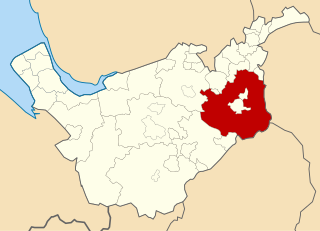
Longdendale Urban District was, from 1936 to 1974, a local government district in the administrative county of Cheshire, England. It encompassed parts of Broadbottom, Hattersley, Hollingworth, Matley and Mottram in Longdendale, all forming part of the non-statutory Longdendale Valley.
The County Borough of Warrington was, from 1847 to 1974, a local government district centred on Warrington in Lancashire, northwest England. It was alternatively known as Warrington County Borough and the County of Warrington.
Limehurst was, from 1894 to 1954, a rural district in the administrative county of Lancashire, England.
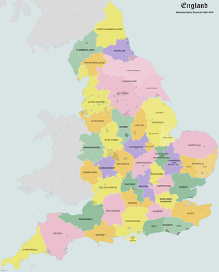
Administrative counties were subnational divisions of England used for local government from 1889 to 1974. They were created by the Local Government Act 1888, which established an elected county council for each area. Some geographically large historic counties were divided into several administrative counties, each with its own county council. The administrative counties operated until 1974, when they were replaced by a system of metropolitan and non-metropolitan counties under the Local Government Act 1972.
Barton-upon-Irwell was, from 1894 to 1933, a rural district in the administrative county of Lancashire, England.

Mottram in Longdendale was one of the eight ancient parishes of the Macclesfield Hundred of Cheshire, England. Centred on St Michael and All Angels Church it included the townships of Godley, Hattersley, Hollingworth, Matley, Newton, Stayley, Tintwistle and Mottram itself. Under the Poor Law Amendment Act 1886 the townships became civil parishes in their own right.

Buxton was an Urban District from 1894 to 1917 and a Municipal Borough from 1917 to 1974 in Derbyshire, England.

New Mills was an Urban District in Derbyshire, England from 1894 to 1974. It was created under the Local Government Act 1894. The district was abolished in 1974 under the Local Government Act 1972 and combined with the Buxton and Glossop Municipal Boroughs, the Whaley Bridge Urban District and the Chapel en le Frith and Tintwistle Rural Districts to form the new High Peak district.
