Tisdale, Saskatchewan

Last updated

Tisdale
Town
Motto: 
Opportunity Grows Here
Canada Saskatchewan location map.svg
Red pog.svg
Tisdale
Coordinates: 52°50′57″N104°02′57″W / 52.84917°N 104.04917°W / 52.84917; -104.04917
CountryCanada
Province Saskatchewan
Rural municipality Tisdale
Post office founded1 February 1904 [1]
Government
  MayorAl Jellicoe [2]
   Federal electoral district Prince Albert MP Randy Hoback
   Provincial constituency Constituency of Carrot River Valley MLA Fred Bradshaw
Area
  Total6.47 km2 (2.50 sq mi)
Population
 (2011)
  Total3,180
  Summer (DST) CST

Tisdale is the business centre for the rich agricultural boreal forest area in central Saskatchewan, Canada. This town is in the Rural Municipality of Tisdale No. 427, Saskatchewan.

Contents

Located at the junction of Highway 35 and Highway 3, and serviced by both the Canadian National Railway and the Canadian Pacific Railway, Tisdale is the grain handling centre of the region with five inland grain terminals, and is the centre of regional industry.

The intersection of Highways 3 and 35 has traffic volumes of 11,200 vehicles per day and is the location of the largest 7-Eleven in Canada (by floor space) and the 4.9 m (16 ft) long roadside statue of "The World's Largest Honey Bee" (the Giant Bee in Falher, is actually bigger at 6.91 m (22 ft 8 in)).

This town is the administrative office of the Kinistin Saulteaux Nation band government.

History

Tisdale, circa 1928 Tisdale, Saskatchewan (circa 1928).jpg
Tisdale, circa 1928

English explorer Henry Kelsey passed through this area in 1690 during his exploration of the Carrot River.

The post office of Tisdale, provisional District of Saskatchewan, North-West Territories was created on 1 February 1904. The community was originally known as "Doghide" after the Doghide River that flows through the town, but with the arrival of the railway the community was renamed "Tisdale" in honour of F.W. Tisdale, an employee of the Canadian Northern Railway. [3]

Western Canada's biggest gun shoot out took place just east of Tisdale in 1920. The historic gunfight involved a posse of Saskatchewan Provincial Police and four outlaws [3]

In 2005, Tisdale celebrated its 100th birthday with a homecoming celebration in conjunction with Saskatchewan's centennial. The town also underwent beautification projects, including the construction of a new town square.

In 2016, Tisdale changed its town motto from "The land of rape and honey" to "Opportunity grows here". [4] [5] [6]

Demographics

In the 2021 Census of Population conducted by Statistics Canada, Tisdale had a population of 2,962 living in 1,379 of its 1,613 total private dwellings, a change of -8.4% from its 2016 population of 3,235. With a land area of 6.56 km2 (2.53 sq mi), it had a population density of 451.5/km2 (1,169.4/sq mi) in 2021. [7]

Canada census – Tisdale, Saskatchewan community profile
2011
Population3,180 (+6.0% from 2006)
Land area6.47 km2 (2.50 sq mi)
Population density491.5/km2 (1,273/sq mi)
Median age46.1 (M: 42.3, F: 48.2)
Private dwellings1,510 (total) 
Median household income
References: 2011 [8] earlier [9] [10]

Economy

For 60 years, until October 2015, [11] Tisdale was known as the "Land of Rape and Honey" due to its significance in both rapeseed and honey production. Tisdale is also known as the Honey Capital of Saskatchewan. One third of the farmland in the Northeast region is cropped into canola and 10% of the honey produced in Canada comes from this area. Traditionally the area produces about 4,100,000 kg (9,000,000 lb) ($7.2 million) in honey. Due to the sexual alternate meaning, industrial metal band Ministry named their 1988 album The Land of Rape and Honey after seeing the motto on a Tisdale souvenir mug. [12] The town adopted the new motto "Opportunity Grows Here" on 22 August 2016. [13]

Attractions

Parks

5 major parks are located within the town. Some regional and provincial parks near Tisdale are:

Sports

Tisdale is the regional sports hub which boasts a 6 sheet curling rink, indoor and outdoor skating rinks, soccer and football fields, indoor gun range and one of Saskatchewan's most picturesque 9 hole golf courses situated along the Doghide River. Tisdale's sporting facilities draw teams and individuals from all over Northeast Saskatchewan and beyond.

Infrastructure

Tisdale Hospital is a 24-bed hospital with four doctors, an ambulance service, and long-term care facilities. [19] [3]

Tisdale has twelve churches, two schools, and the Cumberland Regional College. [3]

Tisdale Airport has a paved runway 14/32 with ARCAL (Aircraft Radio Control of Aerodrome Lighting), two grass runways, 17/35 and 08/26, a terminal building, and several hangars.

Tisdale RecPlex

Tisdale RecPlex (Tisdale's Recreational Centre) [20] is a large 100,000 square foot joint-use complex that includes the following:

An outdoor pool, outdoor ice rink, trails and playing fields are located on the grounds surrounding the complex.

Notable people

See also

Related Research Articles

<span class="mw-page-title-main">Nipawin</span> Town in Saskatchewan, Canada

Nipawin is a town in Saskatchewan, Canada, on the Saskatchewan River portion of Tobin Lake. The town lies between Codette Lake, created by the Francois-Finlay Dam and Tobin Lake, created by the E.B. Campbell Dam built in 1963, renamed from Squaw Rapids. The construction of Francois-Finlay Dam earned Nipawin the nickname the "Town of Two Lakes".

<span class="mw-page-title-main">Biggar, Saskatchewan</span> Town in Saskatchewan, Canada

Biggar is a town in central Saskatchewan, Canada. It is located on Highway 14, 93 kilometres (58 mi) west of Saskatoon, the province's most populous city.

<span class="mw-page-title-main">Rosthern</span> Town in Saskatchewan, Canada

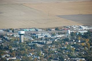
Rosthern is a town at the juncture of Highway 11 and Highway 312 in central Saskatchewan, Canada. It is located roughly halfway between the cities of Prince Albert and Saskatoon.

<span class="mw-page-title-main">Kindersley</span> Town in Saskatchewan, Canada

Kindersley is a town surrounded by the Rural Municipality of Kindersley No. 290 in west-central Saskatchewan, Canada. It is located along Highway 7, a primary highway linking Calgary, Alberta and Saskatoon, at its junction with Highway 21. With a population of 4,567 in 2021, it is an established industrial base for the resource-rich west-central region of the province and a service centre to the oil and gas industry and agriculture production.

Sturgis is a town of 620 people in east-central Saskatchewan, Canada. The Town of Sturgis is 95 km north of Yorkton on Highway 9. It is located in the Assiniboine River valley near the Lakes and Woods region of the province.

<span class="mw-page-title-main">Hazlet, Saskatchewan</span> Village in Saskatchewan, Canada

Hazlet is a village in the Canadian province of Saskatchewan within the Rural Municipality of Pittville No. 169 and Census Division No. 8. The village is located northwest of the city of Swift Current near the Great Sand Hills.

<span class="mw-page-title-main">Outlook, Saskatchewan</span> Town in Saskatchewan, Canada

Outlook is a town in west central Saskatchewan, Canada about 80 kilometres (50 mi) south-southwest of Saskatoon. It is located along the South Saskatchewan River, downstream from Gardiner Dam and the Coteau Creek Hydroelectric Station.

<span class="mw-page-title-main">Falher</span> Town in Alberta, Canada

Falher is a town in the Peace Country area of Alberta, Canada. It is located in the Municipal District of Smoky River No. 130, along Highway 49. Falher is one of the earliest agricultural communities in the Peace River Country and is notable for its sizable francophone population.

<span class="mw-page-title-main">Blaine Lake</span> Town in Saskatchewan, Canada

Blaine Lake is a town in central Saskatchewan, Canada. It is located 85 km north of Saskatoon, 104 km southwest of Prince Albert and 104 km east of North Battleford at the junction of Highway 12 and Highway 40. Nearby are the urban centres of Shellbrook and Rosthern. Blaine Lake is considered the "Gateway to the Northern Lakes" due to its proximity to fishing, hunting and camping sites, as well as its convenient location at a junction of two highways.

Strasbourg is a small town in the Canadian province of Saskatchewan, located about 75 km away from the provincial capital, Regina.

<span class="mw-page-title-main">Craik, Saskatchewan</span> Town in Saskatchewan

Craik is a town in south central Saskatchewan, Canada, incorporated on August 1, 1907. It is strategically located along Provincial Highway 11 in the RM of Craik No. 222, 140 km south-east of Saskatoon and 117 km north-west of Regina.

Arborfield is a town in east-central Saskatchewan, Canada, approximately 70 km (43 mi) north-east of Melfort. The town is located on Highway 23 14 km (8.7 mi) west of the Pasquia Hills. Arborfield is approximately 54 km (34 mi) from Nipawin, 53 km (33 mi) from Tisdale, 266 km (165 mi) from Saskatoon, and 196 km (122 mi) from Prince Albert.

Archerwill is a village in the Canadian province of Saskatchewan within the Rural Municipality of Barrier Valley No. 397 and Census Division No. 14. The village is approximately 55 km (30 mi) north of Wadena, 52 km (30 mi) south of Tisdale and 70 km (40 mi) southeast of the City of Melfort. Since 1981 Archerwill has been the administrative centre of the RM of Barrier Valley.

<span class="mw-page-title-main">Hythe, Alberta</span> Hamlet in Alberta, Canada

Hythe is a hamlet in northwest Alberta, Canada within the County of Grande Prairie No. 1. It is located on Highway 43 approximately 58 km (36 mi) northwest of the City of Grande Prairie and 73 km (45 mi) southeast of the City of Dawson Creek, British Columbia. It held village status prior to July 2021.

<span class="mw-page-title-main">Kerrobert</span> Town in Saskatchewan, Canada

Kerrobert is a town in west central Saskatchewan. It has a population of 970 (2021)

Wilkie is a town in the Canadian province of Saskatchewan, located at Section 5, Township 40, Range 19, west of the 3rd Meridian. The town is at the junctions of Highways 14, 29, and 784.

<span class="mw-page-title-main">Saskatchewan Highway 35</span> Provincial highway in Saskatchewan, Canada

Highway 35 is a paved undivided provincial highway in the Canadian province of Saskatchewan.. It runs from the US Border near Port of Oungre to a dead end near the north shore of Tobin Lake. Saskatchewan Highway 35 (SK Hwy 35) is about 569 kilometres (354 mi) long. The CanAm Highway comprises Saskatchewan Highways 35, SK Hwy 39, SK Hwy 6, SK Hwy 3, SK Hwy 2 and U.S. Route 85. 74.6 kilometres (46.4 mi) of SK Hwy 35 contribute to the CanAm Highway between Port of Oungre on the Canada – United States border and Weyburn. Mudslides, and spring flooding were huge road building and maintenance problems around Nipawin as well as along the southern portion of the route named the Greater Yellow Grass Marsh. Over 20 early dams were built until the problem was addressed with the Rafferty-Alameda Project on the Souris River and the construction of the Qu'Appelle River Dam which have helped to eliminate washed out roads and flooded communities. The highway through the homesteading community followed the Dominion Land Survey on the square until reaching the Saskatchewan River at Nipawin. The completion of the combined railway and traffic bridge over the Saskatchewan River at Nipawin in the late 1920s retired the ferry and basket crossing for traffic north of Nipawin. The E.B. Campbell Dam built in 1963 northeast of Nipawin created Tobin Lake, and Codette Lake was formed with the construction of the Francois-Finlay Hydroelectric dam at Nipawin. The railway/traffic bridge that formed part of Highway 35 was the only crossing utilized at Nipawin until a new traffic bridge was constructed in 1974. The new bridge then became part of the combined Highway 35 and 55 until the highway parts just east of White Fox. Highway 35 then continued north along the west side of Tobin Lake. The railway/traffic bridge continues to be utilized for one lane vehicle traffic controlled by traffic lights, and continues as the "old highway 35" on the west side of the river until it joins with the current Highway 35/55.

<span class="mw-page-title-main">Elrose, Saskatchewan</span> Town in Saskatchewan, Canada

Elrose is a town located just to the north of the Coteau Hills. It is south of Rosetown and north of Swift Current on Highway 4 and Highway 44. A community in the middle of an agricultural economy, Elrose has also become a local hub of activity in the oil industry. The town is surrounded by the Rural Municipality of Monet No. 257.

Mistatim is a village in the Canadian province of Saskatchewan within the Rural Municipality of Bjorkdale No. 426 and Census Division No. 14. It is just north of Highway 3. Mistatim is 35 miles (56 km) east of the Town of Tisdale and 40 miles (64 km) west of Hudson Bay. The Greenwater Lake Provincial Park is 30 miles (48 km) to the south.

<span class="mw-page-title-main">Rural Municipality of Willow Creek No. 458</span> Rural municipality in Saskatchewan, Canada

The Rural Municipality of Willow Creek No. 458 is a rural municipality (RM) in the Canadian province of Saskatchewan within Census Division No. 14 and SARM Division No. 4.

References

  1. "Post Offices and Postmasters" . Retrieved 7 February 2013.
  2. "Municipal Directory System" . Retrieved 7 February 2013.
  3. 1 2 3 4 5 "Town of Tisdale website" . Retrieved 7 February 2013.
  4. "Canadian town drops 'land of rape and honey' slogan". The Guardian. 22 August 2016.
  5. Tasa, Devan (22 August 2016). "Saskatchewan town officially changes 'Land of Rape and Honey' slogan". The Globe and Mail.
  6. Eleftherious-Smith, Loulla-Mae (23 August 2016). "Canadian town changes 'Land of rape and honey' slogan after 60 years". Independent.co.uk .
  7. "Population and dwelling counts: Canada, provinces and territories, census divisions and census subdivisions (municipalities), Saskatchewan". Statistics Canada. 9 February 2022. Retrieved 1 April 2022.
  8. "2011 Community Profiles". 2011 Canadian Census . Statistics Canada. 21 March 2019. Retrieved 7 February 2013.
  9. "2006 Community Profiles". 2006 Canadian Census . Statistics Canada. 20 August 2019.
  10. "2001 Community Profiles". 2001 Canadian Census . Statistics Canada. 18 July 2021.
  11. "'Rape and honey' slogan dropped by Tisdale, Sask". CBC News. 14 October 2015. Archived from the original on 16 October 2015. Retrieved 30 June 2016.
  12. Exclaim! Canada's Music Authority
  13. "Tisdale, Sask., drops 'rape', adds 'opportunity' to town slogan". CBC News. 22 August 2016. Retrieved 22 August 2016.
  14. LARGE CANADIAN ROADSIDE ATTRACTIONS, World's Largest Honey Bee , retrieved 27 May 2007
  15. BIG THINGS IN SASKATCHEWAN, Town of Tisdale, Saskatchewan , retrieved 27 May 2007
  16. "Tisdale Stock Car Club" . Retrieved 7 February 2013.
  17. "Tisdale & District Museum" . Retrieved 7 February 2013.
  18. Town of Tisdale
  19. "Tisdale Hospital" . Retrieved 7 February 2013.
  20. "Tisdale RecPlex" (PDF). Retrieved 7 February 2013.
  21. "Cumberland Regional College" . Retrieved 7 February 2013.
  22. "Tisdale Middle and Secondary School" . Retrieved 7 February 2013.
  23. "Brent Butt releasing animated Christmas special and single". Humboldt Journal. 9 December 2020. Retrieved 12 December 2020.