The Hawthorne Bridge is a truss bridge with a vertical lift that spans the Willamette River in Portland, Oregon, joining Hawthorne Boulevard and Madison Street. It is the oldest vertical-lift bridge in operation in the United States and the oldest highway bridge in Portland. It is also the busiest bicycle and transit bridge in Oregon, with over 8,000 cyclists and 800 TriMet buses daily. It was added to the National Register of Historic Places in November 2012.

A bascule bridge is a moveable bridge with a counterweight that continuously balances a span, or leaf, throughout its upward swing to provide clearance for boat traffic. It may be single- or double-leafed.

The Montlake Bridge is a double-leaf bascule bridge that carries State Route 513 over Seattle's Montlake Cut—part of the Lake Washington Ship Canal—connecting Montlake and the University District.

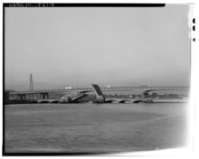
The Burlington Northern Railroad Bridge 5.1 or BNSF Railway Bridge 5.1, also known as the St. Johns Railroad Bridge or the Willamette River Railroad Bridge, is a through truss railway bridge with a vertical lift that spans the Willamette River in Portland, Oregon, United States. Built by the Spokane, Portland and Seattle Railway (SP&S) and completed in 1908, it was originally a swing-span bridge, and its swing-span section was the longest in the world at the time. However, 81 years later the main span was converted from a swing-type to a vertical-lift type, in order to widen the navigation channel. The lift span is one of the highest and longest in the world. The bridge consists of five sections, with the two sections closest to the bank on each side fixed.
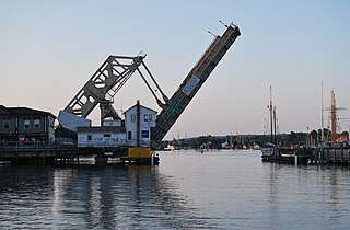
The Mystic River Bascule Bridge is a bascule bridge spanning the Mystic River in Mystic, Connecticut in the United States. It carries vehicle and foot traffic directly into the tourist district of town via 33 ft-wide (10 m) Main Street.
A vertical-lift bridge or just lift bridge is a type of movable bridge in which a span rises vertically while remaining parallel with the deck.

A moveable bridge, or movable bridge, is a bridge that moves to allow passage for boats or barges. In American English, the term is synonymous with drawbridge, and the latter is the common term, but drawbridge can be limited to the narrower, historical definition used in some other forms of English, in which drawbridge refers to only a specific type of moveable bridge often found in castles.

The Cape Cod Canal Railroad Bridge, a vertical lift bridge in Bourne, Massachusetts near Buzzards Bay, carries railroad traffic across the Cape Cod Canal, connecting Cape Cod with the mainland.

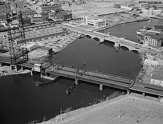
The Newark Bay Bridge of the Central Railroad of New Jersey (CNJ) was a railroad bridge in New Jersey that connected Elizabethport and Bayonne at the southern end of Newark Bay. Its third and final incarnation was a four-track vertical-lift design that opened in 1926, replacing a bascule bridge from 1904 which superseded the original swing bridge from 1887. The bridge served the main line of the CNJ, carrying daily interstate trains as well as commuter trains.

The North Avenue Bridge can refer to one of three bridges that has carried North Avenue over the North Branch of the Chicago River on the north side of Chicago, Illinois. A center-pier swing bridge built in 1877 was replaced in 1907 by a bascule bridge, allowing river traffic more room for maneuvering in and out of the North Canal, just north of Goose Island.
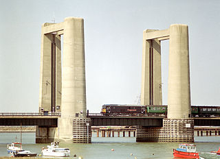
The Kingsferry Bridge is a combined road and railway vertical-lift bridge which connects the Isle of Sheppey to mainland Kent in South East England. The seven-span bridge has a central lifting span which allows ships to pass.

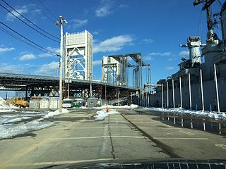
The Henry Ford Bridge, also known as the Badger Avenue Bridge, is a bridge located in Los Angeles County, Southern California. It carries the Pacific Harbor Line railroad across the Cerritos Channel to Terminal Island from San Pedro, to serve the Port of Los Angeles and Port of Long Beach. It was built to accommodate operations at the Ford Long Beach Assembly plant which opened in 1930 and was closed in 1959.

Amtrak's Thames River Bridge spans from New London to Groton, Connecticut, United States, crossing Connecticut's Thames River.

The Amtrak Old Saybrook–Old Lyme Bridge is the last crossing of the Connecticut River before it reaches Long Island Sound. It is a Truss bridge with a bascule span, allowing boat traffic to pass through. The bridge is owned by Amtrak and used by Northeast Regional, Acela Express, Shore Line East and a few freight trains traversing the Northeast Corridor. It can be seen from the Raymond E. Baldwin Bridge, as well as from various points on Route 154.
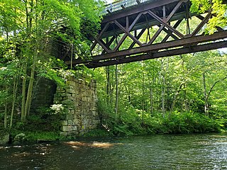
The Blackledge River Railroad Bridge is a Warren truss bridge that was built on the site of a c. 1870 railroad bridge. The original bridge was completed and opened by August 3, 1877. Likely built by the Colchester Railway Company, the bridge was part of the 3.59 miles (5.78 km) of track from Colchester, Connecticut, to Turnerville. The line was leased to the Boston & New York Air Line Railroad and reported improvement in 1879 and a new 110-foot long (34 m) iron bridge by 1881. The line was leased to the New York, New Haven and Hartford Railroad in 1882. After dominating the region, the New York, New Haven and Hartford Railroad petitioned for changes to the Air Line and the approval came on July 7, 1911.
The Pequonnock River Railroad Bridge is a railroad drawbridge over the Pequonnock River in Bridgeport, Connecticut. Owned by the State of Connecticut and maintained and operated by both Amtrak and Metro-North Railroad, it is also referred to as Pequonnock River Bridge, PECK Bridge, and Undergrade Bridge 55.90. Currently the bridge is part of the Northeast Corridor line, carrying rail traffic of Amtrak and Metro-North, as well as freight trains operated by the Providence & Worcester Railroad.

Niantic River Bridge, also known as Amtrak Bascule Bridge No. 116.74, is a railroad bridge carrying Amtrak's Northeast Corridor line across the Niantic River between East Lyme and Waterford, Connecticut. It is a drawbridge with a bascule-type draw span. A new bridge was constructed in 2012 to replace the former span built in 1907. It opened on September 8, 2012. Related construction work finished in June 2013.
The Fore River Bridge spans the Weymouth Fore River between Quincy and Weymouth, Massachusetts. The total length of the bridge including the approaches is 2,216 feet (675 m).
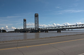
The Rio Vista Bridge is a continuous truss span with a vertical-lift bridge in the middle which carries California State Route 12 across the Sacramento River at Rio Vista, California. The present bridge was completed in 1960 and is one of several moveable bridges spanning rivers in the Sacramento–San Joaquin River Delta. It is named after Helen Madere, who served as vice-mayor of Rio Vista. As of 2013 the bridge carries approximately 21,000 cars per day.