Tonkawa, Oklahoma

Last updated

Tonkawa, Oklahoma
Tonkawa, Oklahoma.JPG
Tonkawa in late 2013
OKMap-doton-Tonkawa.PNG
Location of Tonkawa, Oklahoma
Coordinates: 36°40′59″N97°18′33″W / 36.68306°N 97.30917°W / 36.68306; -97.30917
Country United States
State Oklahoma
County Kay
Area
[1]
  Total4.39 sq mi (11.37 km2)
  Land4.34 sq mi (11.24 km2)
  Water0.05 sq mi (0.13 km2)
Elevation
[2]
994 ft (303 m)
Population
 (2020)
  Total3,015
  Density694.70/sq mi (268.23/km2)
Time zone UTC-6 (Central (CST))
  Summer (DST) UTC-5 (CDT)
ZIP code
74653
Area code 580
FIPS code 40-74150 [3]
GNIS feature ID2412083 [2]
Website tonkawaok.gov

Tonkawa is a city in Kay County, Oklahoma, United States, along the Salt Fork Arkansas River. The population was 3,015 as of the 2020 United States census. [4]

Contents

History

Named after the Tonkawa tribe, the city of Tonkawa was founded in March 1894 by Eli V. Blake and Wiley William Gregory. Blake and Gregory, originally from Kansas, claimed the land that would become Tonkawa in the Land Run of 1893. Prior to the land run, from 1879 to 1885, the area was known as "Fort Oakland", home to the Nez Perce people. In 1885, the remnants of the Tonkawa tribe, who had fled Indian Territory after the 1862 Tonkawa Massacre, returned to settle in the Fort Oakland area. The Blackwell and Southern Railway (later bought by the Atchison, Topeka and Santa Fe Railway) built a line through Tonkawa, which stimulated growth of the town. In 1901, the Oklahoma Territory Legislature established the University Preparatory School (now Northern Oklahoma College) here. By statehood, the population was 1,238. The discovery of oil caused a boom in the 1920s, and the population was 3,311 in 1930. [5]

Camp Tonkawa

During World War II, Tonkawa was home to Camp Tonkawa, a prisoner-of-war camp. Camp Tonkawa remained in operation from August 30, 1943, to September 1, 1945. [6] Built between October and December 1942, the 160-acre (0.65 km2) site contained more than 180 wooden structures for 3,000 German POWs as well as 500 U.S. Army guard troops, service personnel and civilian employees. [7] The first prisoners, consisting of German troops from the Afrika Korps, arrived in August 1943. During their internment, prisoners labored at local farms and ranches. In November 1943, a prison riot caused the death of a German soldier, Johannes Kunze. Eight prisoners briefly escaped, only to be recaptured.

Geography

Tonkawa is located in southwestern Kay County on the Salt Fork of the Arkansas River, 14 miles (23 km) west of Ponca City. U.S. Route 60 passes through the northern side of the city, leading east to Ponca City and west 14 miles (23 km) to Lamont. U.S. Route 77 follows US 60 east to Ponca City, but turns south in Tonkawa and becomes Main Street, then leads south 28 miles (45 km) to Perry. Interstate 35 passes 2 miles (3 km) west of the center of Tonkawa, with access from Exits 211 and 214. I-35 leads south 87 miles (140 km) to Oklahoma City and north 70 miles (110 km) to Wichita, Kansas.

According to the United States Census Bureau, Tonkawa has a total area of 5.4 square miles (14.0 km2), of which 0.03 square miles (0.07 km2), or 0.48%, are water. [8]

Demographics

Historical population
CensusPop.Note
1900 707
1910 1,776151.2%
1920 1,448−18.5%
1930 3,311128.7%
1940 3,197−3.4%
1950 3,64314.0%
1960 3,415−6.3%
1970 3,337−2.3%
1980 3,5245.6%
1990 3,127−11.3%
2000 3,1621.1%
2010 3,2161.7%
2020 3,015−6.2%
U.S. Decennial Census [9]

As of the census [3] of 2000, there were 3,299 people, 1,197 households, and 801 families residing in the city. The population density was 591.3 inhabitants per square mile (228.3/km2). There were 1,417 housing units at an average density of 254.0 per square mile (98.1/km2). The racial makeup of the city was 86.39% White, 0.85% African American, 5.55% Native American, 0.33% Asian, 3.06% from other races, and 3.82% from two or more races. Hispanic or Latino of any race were 6.64% of the population.

There were 1,197 households, out of which 32.0% had children under the age of 18 living with them, 53.8% were married couples living together, 8.9% had a female householder with no husband present, and 33.0% were non-families. 29.1% of all households were made up of individuals, and 13.4% had someone living alone who was 65 years of age or older. The average household size was 2.47 and the average family size was 3.06.

In the city, the population was spread out, with 24.9% under the age of 18, 17.3% from 18 to 24, 23.6% from 25 to 44, 19.0% from 45 to 64, and 15.3% who were 65 years of age or older. The median age was 33 years. For every 100 females, there were 98.1 males. For every 100 females age 18 and over, there were 95.2 males.

The median income for a household in the city was $29,387, and the median income for a family was $35,912. Males had a median income of $27,222 versus $20,128 for females. The per capita income for the city was $14,245. About 12.5% of families and 17.6% of the population were below the poverty line, including 23.9% of those under age 18 and 9.0% of those age 65 or over.

Education

Tonkawa is covered by the Tonkawa Public Schools district which includes Tonkawa Elementary, Tonkawa Middle School, and Tonkawa High School. Tonkawa is also home to Northern Oklahoma College which provides Associates level education.

Points of interest

First Presbyterian Church of Tonkawa
Courtesy of Jeffrey Beall.
December 27, 2013 First Presbyterian Church of Tonkawa.JPG
First Presbyterian Church of Tonkawa
Courtesy of Jeffrey Beall.
December 27, 2013
Tonkawa water tower Tonkawa OK water tower.tif
Tonkawa water tower

Museums

NRHP sites

The following sites in Tonkawa are listed on the National Register of Historic Places in Kay County, Oklahoma:

Notable people

See also

Flag of Kansas.svg  Kansasportal

Related Research Articles

<span class="mw-page-title-main">Nez Perce County, Idaho</span> County in Idaho, United States

Nez Perce County is a county located in the U.S. state of Idaho. As of the 2020 census, the population was 42,090. The county seat is Lewiston. The county is named after the Native American Nez Perce tribe. Nez Perce County is part of the Lewiston, Idaho–WA Metropolitan Statistical Area.

<span class="mw-page-title-main">Wallowa County, Oregon</span> County in Oregon, United States

Wallowa County is the northeastern most county in the U.S. state of Oregon. As of the 2020 census, the population was 7,391, making it Oregon's fifth-least populous county. Its county seat is Enterprise. According to Oregon Geographic Names, the origins of the county's name are uncertain, with the most likely explanation being it is derived from the Nez Perce term for a structure of stakes used in fishing. An alternative explanation is that Wallowa is derived from a Nez Perce word for "winding water". The journals of Lewis and Clark Expedition record the name of the Wallowa River as Wil-le-wah.

<span class="mw-page-title-main">Kay County, Oklahoma</span> County in Oklahoma, United States

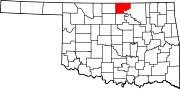
Kay County is a county located in the U.S. state of Oklahoma. As of the 2020 census, its population was 43,700. Its county seat is Newkirk, and the largest city is Ponca City.

<span class="mw-page-title-main">Lewis County, Idaho</span> County in Idaho, United States

Lewis County is a county located in the north central region of the U.S. state of Idaho. As of the 2020 census, the population was 3,533, making it the fourth-least populous county in Idaho. The county seat is Nezperce, and Kamiah is the largest city. Partitioned from Nez Perce County and established in 1911, it was named after the explorer Meriwether Lewis. Most of the county is within the Nez Perce Indian Reservation, though Native Americans comprise less than 6% of the county population. Similar to the opening of lands in Oklahoma, the U.S. government opened the reservation for white settlement in November 1895. The proclamation had been signed less than two weeks earlier by President Cleveland.

<span class="mw-page-title-main">Idaho County, Idaho</span> County in Idaho, United States

Idaho County is a county in the U.S. state of Idaho, and the largest by area in the state. As of the 2020 census, the population was 16,541. The county seat is Grangeville. Previous county seats of the area were Florence (1864–68), Washington (1868–75), and Mount Idaho (1875–1902).

<span class="mw-page-title-main">Clearwater County, Idaho</span> County in Idaho, United States

Clearwater County is a county located in the U.S. state of Idaho. As of the 2020 census, the population was 8,734. The county seat is Orofino. Established in 1911, the county was named after the Clearwater River.

<span class="mw-page-title-main">Orofino, Idaho</span> City in Idaho, United States

Orofino is a city in and the county seat of Clearwater County, Idaho, United States, along Orofino Creek and the north bank of the Clearwater River. It is the major city within the Nez Perce Indian Reservation. The population was 3,142 at the time of the 2010 census.

<span class="mw-page-title-main">Pierce, Idaho</span> City in Idaho, United States

Pierce is a city in the northwest United States, located in Clearwater County, Idaho. The population was 508 at the 2010 census, down from 617 in 2000.

<span class="mw-page-title-main">Kamiah, Idaho</span> City in Idaho, United States

Kamiah is a city in Lewis and Idaho counties in the U.S. state of Idaho. The largest city in Lewis County, it extends only a small distance into Idaho County, south of Lawyer Creek. The population was 1,295 at the 2010 census, up from 1,160 in 2000. The city lies in the narrow valley of the Clearwater River; downstream are Orofino and Lewiston, at the confluence with the Snake River.

<span class="mw-page-title-main">Kooskia, Idaho</span> City in Idaho, United States

Kooskia is a city in Idaho County, Idaho, United States. It is at the confluence of the South and Middle forks of the Clearwater River, combining to become the main river. The population was 607 at the 2010 census, down from 675 in 2000.

<span class="mw-page-title-main">Winchester, Idaho</span> City in Idaho, United States

Winchester is a city in western Lewis County, Idaho, United States, located on the Camas Prairie in the north central part of the state. The population was 356 at the 2020 census, up from 340 in 2010.

<span class="mw-page-title-main">Lapwai, Idaho</span> City in Idaho, United States

Lapwai is a city in Nez Perce County, Idaho, United States. Its population was 1,137 at the 2010 census, and it is the seat of government of the Nez Perce Indian Reservation.

<span class="mw-page-title-main">Garber, Oklahoma</span> City in Oklahoma, United States

Garber is a city in Garfield County, Oklahoma, United States. The population was 822 at the 2010 census. The city is named after Martin Garber, father of Milton C. Garber, former U.S. congressman, Enid mayor, newspaper editor, and judge. The land was previously part of the Cherokee Outlet, until the U.S. government declared it open to non-Indian settlement in 1893.

<span class="mw-page-title-main">Braman, Oklahoma</span> Town in Oklahoma, United States

Braman is a town in Kay County, Oklahoma, United States. The population was 217 at the 2010 census, a decline of 11.1 percent from the figure of 244 in 2000.

<span class="mw-page-title-main">Billings, Oklahoma</span> Town in Oklahoma, United States

Billings is a town in northwest Noble County, Oklahoma, United States. The population was 509 at the 2010 census, an increase from the figure of 436 in 2000. It was the childhood home of Oklahoma governor Henry Bellmon.

<span class="mw-page-title-main">Marland, Oklahoma</span> Town in Oklahoma, United States

Marland is a town in Noble County, Oklahoma, United States. The population was 225 at the 2010 census. It was named for Ernest W. Marland, an oilman from nearby Ponca City who later became a governor of Oklahoma. Marland is on SH-156, south-southwest of Ponca City.

McCord is a census-designated place (CDP) in Osage County, Oklahoma, United States. The population was 1,440 at the 2010 census, a decrease of 15.8 percent from the figure of 1,711 reported in 2000.

<span class="mw-page-title-main">Pawnee, Oklahoma</span> City in Oklahoma, United States

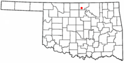
Pawnee is a city and county seat of Pawnee County, Oklahoma, United States. The town is northeast of Stillwater at the junction of U.S. Route 64 and State Highway 18.

<span class="mw-page-title-main">Wallula, Washington</span> CDP in Washington, United States

Wallula is a census-designated place (CDP) in Walla Walla County, Washington, United States. The population was 179 at the 2010 census.

<span class="mw-page-title-main">Ponca City, Oklahoma</span> City in Oklahoma, United States

Ponca City is a city in Kay County in the U.S. state of Oklahoma. The city was named after the Ponca tribe. Ponca City had a population of 24,424 in the 2020 census, down from 25,387 at the time of the 2010 census.

References

  1. "ArcGIS REST Services Directory". United States Census Bureau. Retrieved September 20, 2022.
  2. 1 2 U.S. Geological Survey Geographic Names Information System: Tonkawa, Oklahoma
  3. 1 2 "U.S. Census website". United States Census Bureau . Retrieved January 31, 2008.
  4. "Tonkawa (city), Oklahoma". U.S. Census Bureau. Retrieved March 21, 2024.
  5. Wilson, Linda D. "Tonkawa". Encyclopedia of Oklahoma History and Culture. Oklahoma Historical Society. Archived from the original on June 2, 2010. Retrieved March 15, 2010.
  6. "OK Counties POW Camps/Escapes".
  7. "Camp Tonkawa - World War II German POW Camp ~ Tonkawa, OK - Oklahoma Historical Markers on Waymarking.com" . Retrieved March 15, 2010.
  8. "Geographic Identifiers: 2010 Census Summary File 1 (G001), Tonkawa city, Oklahoma". American FactFinder. U.S. Census Bureau. Archived from the original on February 13, 2020. Retrieved April 15, 2019.
  9. "Census of Population and Housing". Census.gov. Retrieved June 4, 2015.