
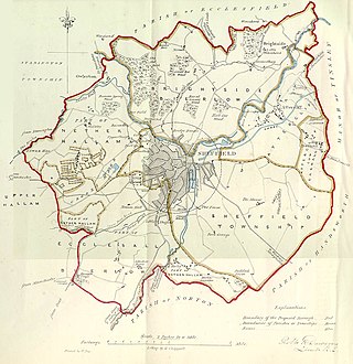
Hallamshire is the historical name for an area of South Yorkshire, England, approximating to the current City of Sheffield local government area.

Ecclesall Ward—which includes the neighbourhoods of Banner Cross, Bents Green, Carterknowle, Ecclesall, Greystones, Millhouses, and Ringinglow—is one of the 28 electoral wards in the Sheffield district, in the county of South Yorkshire, England. It is located in the southwestern part of the city and covers an area of 3.6 square miles. The population of this ward in 2007 was 19,211 people in 7,626 households, reducing to 6,657 at the 2011 Census. Ecclesall ward is one of the four wards that make up the South West Community Assembly and one of five wards that make up the Sheffield Hallam Parliamentary constituency. The Member of Parliament is Olivia Blake, a Labour MP. Ecclesall is one of the least socially deprived wards in the entire country, with a 2002 deprivation score of 4.7—making it the 8,105th most deprived ward out of 8,414 wards in the country. The demographic consists largely of white, middle-class families.
Ruyton-XI-Towns, formally Ruyton of the Eleven Towns or simply Ruyton, is a village and civil parish next to the River Perry in Shropshire, England. It had a population of 1,379 at the 2011 Census.
The Metropolitan Borough of Wigan is a metropolitan borough of Greater Manchester, England. It is named after its largest town, Wigan but covers a far larger area which includes the towns of Atherton, Ashton-in-Makerfield, Golborne, Hindley, Ince-in-Makerfield, Leigh and Tyldesley. The borough also covers the villages and suburbs of Abram, Aspull, Astley, Bryn, Hindley Green, Lowton, Mosley Common, Orrell, Pemberton, Shevington, Standish, Winstanley and Worsley Mesnes. The borough is also the second-most populous district in Greater Manchester.
The City of Sheffield is a city and metropolitan borough in South Yorkshire, England. The metropolitan borough includes the administrative centre of Sheffield, the town of Stocksbridge and the larger village of Chapeltown and part of the Peak District. It has a population of 566,242 (2022), making it technically the third largest city in England by population behind Birmingham and Leeds, since London is not considered a single entity. It is governed by Sheffield City Council.

Oxton is a suburb of Birkenhead, Merseyside, England. Administratively it is a ward of the Metropolitan Borough of Wirral. Originally a village in its own right, it became part of the Municipal Borough of Birkenhead upon its creation in 1877. Before local government reorganisation on 1 April 1974, it was part of the County Borough of Birkenhead, within the county of Cheshire.

Sheffield Attercliffe was a parliamentary constituency in the City of Sheffield. It was created at the 1885 general election and abolished at the 2010 general election, when it was replaced by a new Sheffield South East constituency.

A civil parish is a subnational entity, forming the lowest unit of local government in England. There are 21 civil parishes in the ceremonial county of West Midlands, most of the county being unparished; Dudley, Sandwell, Walsall and Wolverhampton are completely unparished. At the 2001 census, there were 89,621 people living in the parishes, accounting for 3.5 per cent of the county's population.
A civil parish is a country subdivision, forming the lowest unit of local government in England. There are 22 civil parishes in the ceremonial county of Merseyside, most of the county being unparished; Liverpool and Wirral are completely unparished. At the 2001 census, there were 177,663 people living in the parishes, accounting for 13.0 per cent of the county's population.

Heeley is a former cluster of Derbyshire villages. Which all now form a suburb in the south of the city of Sheffield, South Yorkshire, England. The village has existed at least since 1343, its name deriving from Heah Leah, High Lea then Hely, meaning a high, woodland clearing. Originally Heeley was divided into three: Upper Heeley was around the intersection of Myrtle Road and Heeley Green, Middle Heeley was on the Gleadless Road at Well Road, and Lower Heeley was on the London Road around Artisan View. At the 2011 Census the village formed part of the Gleadless Valley ward of the City of Sheffield.

Fulwood ward—which includes the districts of Fulwood, Lodge Moor, and Ranmoor—is one of the 28 electoral wards in the City of Sheffield, England. It is located in the far western part of the city and covers an area of 23.2 km2. The population of this ward in 2011 was 18,233 people in 6,476 households. Fulwood ward is one of the five wards that make up the Sheffield Hallam Parliamentary constituency. As of June 2022, Andrew Sangar, Sue Alston, and Cliff Woodcraft, all Liberal Democrats, were councillors for the ward. The current Member of Parliament is Labour's Olivia Blake.

The areas of Sheffield, a city and metropolitan borough in the north of England, vary widely in size and history. Some of the areas developed from villages or hamlets, that were absorbed into Sheffield as the city grew, and thus their centres are well defined, but the boundaries of many areas are ambiguous. The areas of Sheffield do not play a significant administrative role, but the city is divided into 28 electoral wards for local elections and 6 parliamentary constituencies for national elections.
Sheffield was a borough constituency represented in the House of Commons of the Parliament of the United Kingdom from 1832 to 1885. It elected two Members of Parliament (MPs) by the bloc vote system of elections.

Billinge is a village within the Metropolitan Borough of St Helens, Merseyside, England. It forms the larger part of the civil parish of Billinge Chapel End.
Vill is a term used in English, Welsh and Irish history to describe a basic rural land unit, roughly comparable to that of a parish, manor, village or tithing.
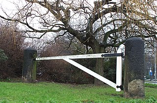
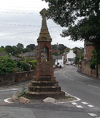
Hunter's Bar is a roundabout and former toll bar on Ecclesall Road in south-west Sheffield, England; the toll bar was active until the late 19th century. The name also attaches to the area surrounding Hunter's Bar roundabout at the intersection of Ecclesall Road, Brocco Bank, Sharrow Vale Road and Junction Road. The toll bar now stands in the middle of the roundabout. The gatekeeper for the toll bar, known as "Hunter's Toll Gate" lived in a house on the corner of Ecclesall Road and Sharrow Vale Road. In 1871, the gatekeeper was Jacob Thompson, who was born in Wirksworth, Derbyshire and had previously been a lead miner there. His wife and two daughters lived with him.
Halesowen was a medieval parish in the West Midlands of England.

Brightside is an industrial area of Sheffield, South Yorkshire, England lying on a hill north of Attercliffe and the River Don.

Sheffield South East is a constituency represented in the House of Commons of the UK Parliament since its 2010 creation by Clive Betts, a member of the Labour Party.

Mosborough is a village in the City of Sheffield in South Yorkshire, England. Historically part of Derbyshire, the village was named after The Moss river which flows through the village. During the late 19th century and 20th century, the village was noted for its steelmaking, with Hutton & Co. Sickle works being based at nearby Ridgeway. The village expanded due to developments in nearby Owlthorpe, Westfields and Waterthorpe. Mosborough, which was a township at the time, was transferred from Derbyshire to the West Riding of Yorkshire as part of Sheffield.
