Traffic comprises pedestrians, vehicles, ridden or herded animals, trains, and other conveyances that use public ways (roads/sidewalks) for travel and transportation.

Transportation engineering or transport engineering is the application of technology and scientific principles to the planning, functional design, operation and management of facilities for any mode of transportation in order to provide for the safe, efficient, rapid, comfortable, convenient, economical, and environmentally compatible movement of people and goods transport.

A roundabout, a rotary and a traffic circle are all, with certain distinctions between them, a type of circular intersection or junction in which road traffic is permitted to flow in one direction around a central island, and priority is typically given to traffic already in the junction.

An intelligent transportation system (ITS) is an advanced application which aims to provide innovative services relating to different modes of transport and traffic management and enable users to be better informed and make safer, more coordinated, and 'smarter' use of transport networks.

A ramp meter, ramp signal, or metering light is a device, usually a basic traffic light or a two-section signal light together with a signal controller, that regulates the flow of traffic entering freeways according to current traffic conditions. Ramp meters are used at freeway on-ramps to manage the rate of automobiles entering the freeway. Ramp metering systems have proved to be successful in decreasing traffic congestion and improving driver safety.

Traffic lights, traffic signals, or stoplights – also known as robots in South Africa and Namibia – are signalling devices positioned at road intersections, pedestrian crossings, and other locations in order to control the flow of traffic.

Traffic calming uses physical design and other measures to improve safety for motorists, car drivers, pedestrians and cyclists. It has become a tool to combat speeding and other unsafe behaviours of drivers. It aims to encourage safer, more responsible driving and potentially reduce traffic flow. Urban planners and traffic engineers have many strategies for traffic calming, including narrowed roads and speed humps. Such measures are common in Australia and Europe, but less so in North America. Traffic calming is a calque of the German word Verkehrsberuhigung – the term's first published use in English was in 1985 by Carmen Hass-Klau.

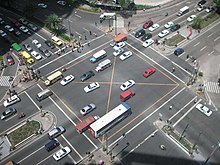
Traffic congestion is a condition in transport that is characterized by slower speeds, longer trip times, and increased vehicular queueing. Traffic congestion on urban road networks has increased substantially since the 1950s. When traffic demand is great enough that the interaction between vehicles slows the traffic stream, this results in congestion. While congestion is a possibility for any mode of transportation, this article will focus on automobile congestion on public roads.

Rumble strips are a traffic calming feature to alert inattentive drivers of potential danger, by causing a tactile fuzzy vibration and audible rumbling transmitted through the wheels into the vehicle interior. A rumble strip is applied along the direction of travel following an edgeline or centerline, to alert drivers when they drift from their lane. Rumble strips may also be installed in a series across the direction of travel, to warn drivers of a stop or slowdown ahead, or of an approaching danger spot.

Vehicular cycling is the practice of riding bicycles on roads in a manner that is in accordance with the principles for driving in traffic, and in a way that places responsibility for safety on the individual.
In transportation engineering, traffic flow is the study of interactions between travellers and infrastructure, with the aim of understanding and developing an optimal transport network with efficient movement of traffic and minimal traffic congestion problems.

Access management, also known as access control, when used in the context of traffic and traffic engineering, generally refers to the regulation of interchanges, intersections, driveways and median openings to a roadway. Its objectives are to enable access to land uses while maintaining roadway safety and mobility through controlling access location, design, spacing and operation. This is particularly important for major roadways intended to provide efficient service to through-traffic movements.
Vehicle infrastructure integration (VII) is an initiative fostering research and application development for a series of technologies directly linking road vehicles to their physical surroundings, first and foremost to improve road safety. The technology draws on several disciplines, including transport engineering, electrical engineering, automotive engineering, and computer science. VII specifically covers road transport, although similar technologies are in place or under development for other modes of transport. Planes, for example, use ground-based beacons for automated guidance, allowing the autopilot to fly the plane without human intervention. In highway engineering, improving the safety of a roadway can enhance overall efficiency. VII targets to improve both safety and efficiency.

Active traffic management is a method of increasing peak capacity and smoothing traffic flows on busy major highways. Techniques include variable speed limits, hard-shoulder running and ramp-metering controlled by overhead variable message signs. It has been implemented in several countries, including Germany, the United Kingdom, Canada and the United States.
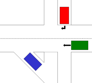
In road design, a slip lane is a road at a junction that allows road users to change roads without actually entering an intersection. Slip lanes are "helpful ...for intersections designed for large buses or trucks to physically make a turn in the space allotted, or where the right turn is sharper than a 90 degree turn." Slip lanes may reduce congestion and "t-bone" motor vehicle collisions, but they increase the risk for pedestrians, cyclists and horse riders who cross the slip lane.

A roadway departure is a type of incident that occurs when a vehicle leaves the roadway. Such incidents can lead to a single-vehicle collision.
Paramics is traffic microsimulation software, originally developed by Quadstone Ltd. There is a related pedestrian microsimulation product called the Urban Analytics Framework.

Terminology related to road transport—the transport of passengers or goods on paved routes between places—is diverse, with variation between dialects of English. There may also be regional differences within a single country, and some terms differ based on the side of the road traffic drives on. This glossary is an alphabetical listing of road transport terms.

A managed lane is a type of highway lane that is operated with a management scheme, such as lane use restrictions or variable tolling, to optimize traffic flow, vehicle throughput, or both. Definitions and goals vary among transport agencies, but managed lanes are generally implemented to achieve an improved operational condition on a highway, such as improving traffic speed and throughput, reducing air pollution, and improving safety. Types of managed lanes include high-occupancy vehicle (HOV) lanes, high-occupancy toll lanes, express toll lanes, reversible lanes, and bus lanes. Most managed lane facilities are located in the United States and Canada, although HOV and bus lanes can be found in many other countries; outside of the US and Canada, many countries use active traffic management that manage all lanes of a highway.

Baher Abdulhai is a Canadian civil engineer, academic, entrepreneur, and researcher. He is a Professor in the Department of Civil Engineering, Director of Intelligent Transportation Systems Centre, and Co-Director of iCity Centre for Automated and Transformative Transportation at the University of Toronto. He is also the CEO and managing director of IntelliCAN Transportation System Inc.