Commuting statistics for major U.S. cities in 2008.
Mass transit
Portland has a public transportation system. The bus and rail system is operated by TriMet, its name reflecting the three metropolitan area counties it serves (Multnomah, Clackamas, and Washington). Portland's rate of public transit use (12.6% of commutes in 2008) is comparable to much larger cities like Los Angeles, and higher than in most similarly sized U.S. cities, but is lower than in some others, such as Baltimore and Seattle.[4] Transit service between Portland and Vancouver, Washington, the second-largest city in the metropolitan area, is provided by C-Tran, with a small number of express routes.
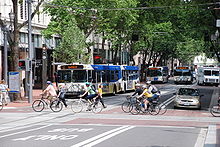
Buses and bikes in downtown Portland.
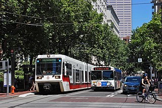
Within the downtown area (the city center) is the Portland Transit Mall, a transit-priority corridor on which buses and light rail trains from many different parts of the region converge. First opened in 1977, and for three decades served only by buses, the transit mall underwent major changes in 2009. Tracks for light rail (MAX) were added, bus stops spaced farther apart, and the left lane opened to general traffic (but with right turns prohibited).[5] To facilitate this major renovation and rebuilding, lasting more than two years, all bus routes using the mall were diverted to other streets (mainly 3rd and 4th avenues) starting in January 2007.[6] The transit mall reopened to buses on May 24, 2009,[7] and operator training runs on the new light-rail tracks took place during the late spring and summer.[8] Light rail service on the transit mall was introduced on August 30, 2009, when the MAX Yellow Line moved to the mall from its previous routing.[9] The new MAX Green Line opened 13 days later, on September 12, and it also serves the downtown transit mall.[10]
From 1975 to 2010, all of downtown Portland was in Fareless Square, a fare zone within which all rides on buses, light rail and streetcars were fare-free, and starting in 2001 this zone also covered a portion of the adjacent Lloyd District. In 2010, free rides became limited to light-rail and streetcar service– no longer covering bus service– and the zone was renamed the "Free Rail Zone".[11] In September 2012, the fareless zone was discontinued entirely, due to a $12million shortfall in TriMet's annual budget.[12]
Ben Holladay was the first person to offer public transportation to the city of Portland when in 1872 he opened the Portland Street Railway Company, a horsecar line on First Street extending to a garage at the end of Glisan.[13] In 1882, a second horsecar system was built for Third Street.[14] Ferries such as the O&CRR Ferry#2 were used to cross the Willamette River before the construction of the first Steel Bridge in 1888. At that point, rail expanded into Albina and East Portland. Horsecars took passengers across the river and steam trains took them further into the suburbs,[15] but both modes were soon replaced by electric streetcar lines, the first of which began operation on November 1, 1889, between St. Johns and Portland.[16]
Buses
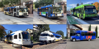
TriMet operates a fleet of 688 buses on a network of 79 bus routes.[17] Twelve of the routes are designated "Frequent Service" bus routes, with more frequent schedules than other routes.[17] Originally intended to have buses scheduled every 15 minutes or less all day, every day (including weekends and holidays), budget cutbacks in 2009 caused TriMet to change "Frequent Service" routes to have 15-minute-or-less wait times only during weekday peak usage times in the morning and afternoon.[18] In August 2014, TriMet reintroduced 15-minutes-or-less wait times at all times during weekdays on Frequent Service routes, with the stated goal of reinstating weekend 15-minutes-or-less wait times on these routes.[18]
TriMet's bus fleet is made up of 40-foot (12m) and 30-foot (9m) buses, built in 2000 or later, and all are low-floor buses, the last of the high-floor models having been retired in 2016. The last non-air-conditioned buses were retired in December 2015.[19]
TriMet's bus routes also include express buses from downtown Portland to South Beaverton, Sherwood and Oregon City, and express buses from Marquam Hill to Beaverton, Tigard, Southwest Portland, and Milwaukie. TriMet also has several "cross-town" routes that do not serve downtown Portland. The bus network operates predominately in a hub-and-spoke network starting with the downtown Portland transit mall, and includes outlying transit centers in Portland's suburbs.
In addition to the fixed-route service, TriMet operates a paratransit service known as LIFT which operates 253 minibuses and 15 sedans offering door-to-door service for citizens who cannot access regular TriMet services.[17]
Since September 2015, Portland's light rail system, named MAX (short for Metropolitan Area Express), consists of five color-coded lines:
The Blue Line is a 33-mile (53km) east-west route. It begins in Hillsboro, a western suburb, passes through Beaverton and downtown Portland, then across the Willamette River, through Northeast Portland and east to the city of Gresham. The 15-mile (24km) line between downtown and Gresham was the first light rail line opened in Portland, in 1986. MAX lines first became designated by colors in 2000.
The Yellow Line added 5.8 miles (9.3km) to the system. It connects North Portland's Expo Center with downtown. This line is often referred to as "Interstate MAX" because much of it runs along Interstate Avenue, and parallel to I-5. Until 2009, the Yellow Line followed the same mostly east-west alignment through downtown Portland as used by the Blue and Red lines, traveling along Morrison Street (westbound) and Yamhill Street (eastbound) through the core of the business district. However, on August 30, 2009, the Yellow Line shifted to a new north-south alignment through downtown that had been constructed along the Portland Mall (see Green Line).[20] In 2015, the Yellow Line became through-routed at all times with the then-new Orange Line (see below).
The Green Line runs from Clackamas Town Center, in the Clackamas area, north along I-205 for 6.5 miles (10.5km) to the Gateway Transit Center, where the Blue and Red Lines meet. From Gateway, it joins them and travels westwards to downtown Portland along the 1986-opened tracks extending to the Steel Bridge. From there—a new junction on the bridge's west deck—the Green Line uses 1.8 miles (2.9km) of new tracks passing Union Station and running mainly along the transit mall for the remainder of its route through downtown, sharing that routing with the Yellow Line (and since 2015 the Orange Line) and terminating at Portland State University (PSU).[10]
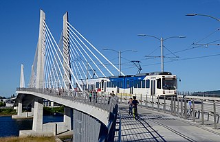
The Orange Line added 7.3 miles (11.7km) of newly constructed line, extending from the south end of the Portland Mall to Milwaukie. The project included construction of the Tilikum Crossing, the first new bridge opened across the Willamette River in Portland in 42 years (since 1973),[21] which is also notable for being open only to transit vehicles, pedestrians and cyclists—and not private vehicles.[21][22] From the PSU area in downtown, the Orange Line follows streets and a bus-and-light-rail-only viaduct to reach the South Waterfront district. After crossing the river, the line turns southward, passing through Southeast Portland along a new median on SE 17th Avenue and then mostly along or adjacent to previously existing railroad rights-of-way to downtown Milwaukie. The terminal station is at Park Avenue, just south of downtown Milwaukie. Operationally, it is linked to the Yellow Line at all times; southbound Yellow Line trains become Orange Line trains when they depart from Rose Quarter TC, and northbound Orange Line trains become Yellow Line trains when they reach the transit mall in downtown Portland.
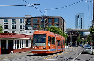
The system's second line opened in 2012 and extended service across the Willamette River to the Lloyd District and the Central Eastside.[25] The federal share of funding for this $148-million project, a 3.3-mile (5.3km) extension and fleet expansion,[25] was approved in April 2009,[26] and construction began in August 2009. Originally named the Central Loop Line, or CL Line, it was renamed the A Loop (clockwise) and B Loop (counterclockwise) in 2015, when it was extended from the eastside across the Tilikum Crossing bridge and also along the NS Line from South Waterfront to Portland State University. See Portland Streetcar (Eastside line) and Loop Service (Portland Streetcar) for more detail.
The Willamette Shore Trolley is a seasonal, volunteer-operated heritage streetcar service established in 1990 – after a 1987 trial run – for the purpose of preserving an approximately 6-mile (10km) former Southern Pacific railroad right-of-way running south from Portland to Lake Oswego for possible future transit use. Plans to extend the Portland Streetcar along the right-of-way were mothballed in early 2012, but remain under consideration for the long term.[27] The right-of-way was acquired by a consortium of local governmental entities in 1988 for this purpose.[28]
Amtrak also exists as a rail commuting option in the Portland area with the Amtrak Cascades providing daily service between Portland and neighboring Oregon City.[30] While the frequency is less than that of TriMet, the 20-minute ride from Oregon City is faster, has cheaper tickets, and is arguably a more comfortable service.[31]
See the Intercity service section below for information about the many intercity bus and train services to and from Portland from outside the metro area.
The average amount of time people spend commuting with public transit in Portland, OR, for example to and from work, on a weekday is 90 min. 36% of public transit riders, ride for more than 2 hours every day. The average amount of time people wait at a stop or station for public transit is 14 min, while 21% of riders wait for over 20 minutes on average every day. The average distance people usually ride in a single trip with public transit is 8.2km, while 18% travel for over 12km in a single direction.[32]
Bicycle use in Portland has been growing rapidly, having nearly tripled since 2001; for example, daily bicycle traffic on four of the Willamette River bridges has increased from 2,855 before 1992 to over 16,000 in 2008[update], partly due to improved facilities.[33] Approximately 8% of commuters bike to work in Portland, the highest proportion of any major U.S. city and about 10 times the national average.[34] In July 2016, Portland introduce a bike share program known as Biketown,[35] initially running with 1,000 bikes. The bikes were provided by Social Bicycles,[36] and the program is operated by Motivate.[37]
Walking
According to a city video, in 1994 Portland became the first city to develop a pedestrian master plan.[38] Blocks in the downtown area are only 200 feet (61m) long. Many streets in the outer southwest section of the city lack sidewalks; however, this is partially made up with various off-street trails.[39] A 2011 study by Walk Score ranked Portland the 12th most walkable of the fifty largest cities in the United States.[40]
Ride-share scooters from two different providers parked on a sidewalk in Northwest Portland
Electric scooter sharing systems have become popular in the past few years as an alternative form of transportation. They first came to Portland in July 2018, after being approved for a four-month pilot program.[42] Scooters returned to Portland in April 2019 for a one-year program after positive review by the city of the first program.[43] The system works much like most bike share systems which have also become popular in Portland and around the world. Users unlock and pay for a scooter with an app on their smartphone and then can drop it off anywhere when done with it. There were many complaints about the effectiveness and safety of the program when the program first returned to Portland. A report done by the city shows that over 700,000[44] rides were taken during the pilot program and that scooters are equally dangerous to other transportation systems but that many riders did not follow the safety regulations such as wearing a helmet.[43] However despite this there are still a lot of concerns. In response to some of the backlash around safety Portland instituted specific laws that apply to scooters, which include that all riders must wear a helmet, must be 16 or older, must not ride on the sidewalk or in city parks, and must yield to pedestrians.[45] In addition to some of the safety concerns there were also concerns about access both for low-income residents and residents with mobility issues. The city has responded to both of these and each scooter company now has discounted rates for low-income residents. These rates differ significantly by company with some being a small discount and others being up to 50 free rides of 30 minutes or less a month.[46] All companies also offer options for non-smartphone users although most of these still require being able to receive SMS texts.[47] The city has passed codes that outlaw leaving the scooters in the middle of sidewalks in response to complaints about the scooters, but it is unclear how often that is being enforced. Despite all of these measures taken by the City of Portland as well as the individual companies there is still much concern and controversy around the scooters. Many are still concerned about inclusivity and disability access as well safety as all complaints about riders leaving or riding the scooters on the sidewalk and not wearing helmets will be dealt with by the private companies, not the city itself.[44] There are also concerns about access to the scooters in all parts of Portland particularly the low-income neighborhoods as most of the scooters have been centered in downtown and other wealthier and popular tourist parts of the city. As the program is still new there is a lack of data about whether or not this program is decreasing the reliance on cars and providing alternative forms of transportation in the city as its original goal. According to a report done by the city, 34% of local riders used the scooters instead of driving and 48% of visitors used the scooters rather than driving or using a rideshare system.[44] It is unclear whether these numbers have increased or decreased with the new year-long program and as with other new technologies there are still many concerns surrounding the scooters. In June 2019, more than 50 scooters from various companies were pulled out of the Willamette River in Portland by a dive team from the Multnomah County Sheriff’s office. It is unclear who put them there or why, and it is unclear how long they were there before being spotted by the divers.[48]
Many streets in Portland are one-way; streets in downtown Portland (Southwest Portland bounded by I-405 and the Willamette River) are virtually all one-way, forming a grid of alternating street traffic: for north-south streets, odd-numbered avenues (1st, 3rd, etc.) are southbound, while even-numbered avenues (2nd, 4th, etc.) are northbound, and similarly east-west streets alternate. This is partly due to the streets in downtown Portland being relatively narrow (64 feet (20m)).[clarification needed] This grid extends a short way west across I-405 into Goose Hollow, terminating at SW 18th Avenue, and extends to some degree north across Burnside Street into the Pearl District, particularly with the north-south streets extending into Old Town.
Most streets on the east side are two-way, but there are a number of one-way pairs along major routes: Martin Luther King Jr. Blvd. (MLK)/Grand Avenue (the equivalent of 4th and 5th avenues), and 11th/12th east-west pairs are connected with bridges, with NE Couch/Burnside forming a pair east of the Burnside Bridge from 3rd to 14th avenues, SE Morrison/SE Belmont forming a pair from the Morrison Bridge to SE 25th Ave, and SE Madison/SE Hawthorne forming a pair from the Hawthorne Bridge to SE 12th Avenue. [49]
Portland's main airport is the Portland International Airport(IATA: PDX, ICAO: KPDX), located in the northeast quadrant, near the Columbia River, and 20 minutes by car from downtown. PDX is also connected to the downtown business and arts districts by the MAX Red Line. The city's first airport, Swan Island Municipal Airport, opened in 1927 and closed in the 1940s.
The Port of Portland's Hillsboro Airport(IATA: HIO, ICAO: KHIO) is an executive and general aviation airport located in Hillsboro, Oregon, and it the second busiest airport in the state. It is connected to the metropolitan area by the MAX Blue Line, and is the starting point for many corporate and charter flights, including Nike, Inc.
Skateboarding and roller blading are welcome methods for travel around town. Downtown Portland includes signs labeled "skate routes" to aid the urban skater.[57]The Wall Street Journal stated Portland "may be the most skateboard-friendly town in America."[58]
↑ Morgan, Steve. "Expansion for Portland's MAX: New routes and equipment", pp. 38-40. Passenger Train Journal, "2010:1" issue (1st quarter, 2010). White River Productions.
Italics denote lines or services which are planned, under construction, or otherwise not operating at the present time.
Related Research Articles
The Metropolitan Area Express (MAX) is a light rail system serving the Portland metropolitan area in the U.S. state of Oregon. Owned and operated by TriMet, it consists of five lines that together connect the six sections of Portland; the communities of Beaverton, Clackamas, Gresham, Hillsboro, Milwaukie, and Oak Grove; and Portland International Airport to Portland City Center. Trains run seven days a week with headways of between 30 minutes off-peak and three minutes during rush hours. In 2019, MAX had an average daily ridership of 120,900, or 38.8 million annually. Due to the COVID-19 pandemic, which impacted public transit use globally, annual ridership plummeted, with only 14.8 million riders recorded in 2021.
Milwaukie is a city mostly in Clackamas County, Oregon, United States; a very small portion of the city extends into Multnomah County. The population was 21,119 at the 2020 census. Founded in 1847 on the banks of the Willamette River, the city, known as the Dogwood City of the West, was incorporated in 1903 and is the birthplace of the Bing cherry. The city is now a suburb of Portland and also adjoins the unincorporated areas of Clackamas and Oak Grove.
The Portland Streetcar is a streetcar system in Portland, Oregon, that opened in 2001 and serves areas surrounding downtown Portland. The 3.9-mile (6.3 km) NS Line runs from Northwest Portland to the South Waterfront via Downtown and the Pearl District. The Loop Service, which opened in September 2012 as the Central Loop, runs from Downtown to the Oregon Museum of Science and Industry via the Pearl District, the Broadway Bridge across Willamette River, the Lloyd District, and the Central Eastside Industrial District and added 3.3 miles (5.3 km) of route. In September 2015 the line was renamed as the Loop Service, with the A Loop traveling clockwise, and the B Loop traveling counterclockwise. The two-route system serves some 20,000 daily riders.
The Tri-County Metropolitan Transportation District of Oregon (TriMet) is a public agency that operates mass transit in a region that spans most of the Portland metropolitan area in the U.S. state of Oregon. Created in 1969 by the Oregon legislature, the district replaced five private bus companies that operated in the three counties: Multnomah, Washington, and Clackamas. TriMet started operating a light rail system, MAX, in 1986, which has since been expanded to five lines that now cover 59.7 miles (96.1 km), as well as the WES Commuter Rail line in 2009. It also provides the operators and maintenance personnel for the city of Portland-owned Portland Streetcar system. In 2022, the system had a ridership of 53,889,500, or about 196,100 per weekday as of the third quarter of 2023.
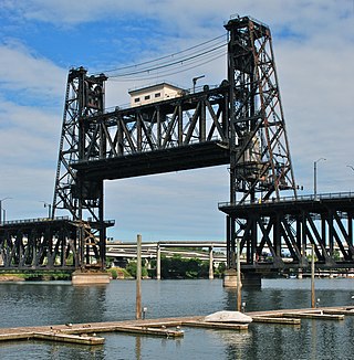
The Steel Bridge is a through truss, double-deck vertical-lift bridge across the Willamette River in Portland, Oregon, United States, opened in 1912. Its lower deck carries railroad and bicycle/pedestrian traffic, while the upper deck carries road traffic, and light rail (MAX), making the bridge one of the most multimodal in the world. It is the only double-deck bridge with independent lifts in the world and the second oldest vertical-lift bridge in North America, after the nearby Hawthorne Bridge. The bridge links the Rose Quarter and Lloyd District in the east to Old Town Chinatown neighborhood in the west.
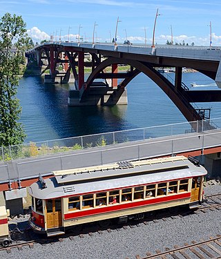
The Willamette Shore Trolley is a heritage railroad or heritage streetcar that operates along the west bank of the Willamette River between Portland and Lake Oswego in the U.S. state of Oregon. The right-of-way is owned by a group of local-area governments who purchased it in 1988 in order to preserve it for potential future rail transit. Streetcar excursion service began operating on a trial basis in 1987, lasting about three months, and regular operation on a long-term basis began in 1990. The Oregon Electric Railway Historical Society has been the line's operator since 1995.
Portland Union Station is a train station in Portland, Oregon, United States, situated near the western shore of the Willamette River in Old Town Chinatown. It serves as an intermediate stop for Amtrak's Cascades and Coast Starlight routes and, along with King Street Station in Seattle, is one of two western termini of the Empire Builder. The station is a major transport hub for the Portland metropolitan area with connections to MAX Light Rail, the Portland Streetcar, and local and intercity bus services. The station building contains Wilf's Restaurant & Bar on the ground level and offices on the upper floors. It also has Amtrak's first Metropolitan Lounge on the West Coast, which is reserved for first-class sleeping car and business-class passengers.
Fareless Square was an area within central Portland, Oregon, where all rides on TriMet buses and light rail and the Portland Streetcar were free. It primarily consisted of the downtown area and, after 2001, the Lloyd District. It existed from January 1975 through August 2012, but was briefly renamed the Free Rail Zone in January 2010 after its coverage became limited to light rail and streetcar service, with bus rides no longer being free. The TriMet board decided in June 2012 to discontinue the Free Rail Zone primarily to help fill a large shortfall in the agency's budget, and the action was one component of a package of extensive budget cuts which also included service reductions and fare increases. The Free Rail Zone ended on August 31, 2012.
The MAX Blue Line is a light rail service in Portland, Oregon, United States, operated by TriMet as part of the MAX Light Rail system. It travels east–west for approximately 33 miles (53 km)—the longest in the network—between Hillsboro, Beaverton, Portland, and Gresham and serves 48 stations from Hatfield Government Center to Cleveland Avenue. The line carried an average 55,370 riders each day on weekdays in September 2018, the busiest of the five MAX lines. It runs for 221⁄2 hours per day from Monday to Thursday, with headways of between 30 minutes off-peak and five minutes during rush hour. Service runs later in the evening on Fridays and Saturdays and ends earlier on Sundays.
The MAX Yellow Line is a light rail service in Portland, Oregon, United States, operated by TriMet as part of the MAX Light Rail system. It connects North Portland to Portland City Center and Portland State University (PSU) with 17 stops from Expo Center station to PSU South/Southwest 6th and College station. The line travels from Portland Expo Center in the north, south to the Rose Quarter through a 5.8-mile (9.3 km) light rail segment along the median of Interstate Avenue. From the Rose Quarter, it crosses the Willamette River via the Steel Bridge and enters downtown Portland, where it operates as a northbound-only service of the Portland Transit Mall on 6th Avenue. Service runs for approximately 21 hours daily with a headway of 15 minutes during most of the day.
Downtown Portland is the central business district of Portland, Oregon, United States. It is on the west bank of the Willamette River in the northeastern corner of the southwest section of the city and where most of the city's high-rise buildings are found.
The MAX Green Line is a light rail service in Portland, Oregon, United States, operated by TriMet as part of the MAX Light Rail system. It is 15 miles (24.1 km) long and serves 30 stations from the PSU South stations to Clackamas Town Center Transit Center; it connects Portland State University (PSU), Portland City Center, Northeast Portland, Southeast Portland, and Clackamas. The Green Line is the only service that shares parts of its route with the four other MAX services, sharing the Portland Transit Mall with the Orange and Yellow lines and the Banfield segment of the Eastside MAX with the Blue and Red lines. Southbound from Gateway/Northeast 99th Avenue Transit Center, it operates the Interstate 205 (I-205) segment through to Clackamas Town Center. Service runs for approximately 211⁄2 hours daily with a headway of 15 minutes during most of the day. It is the third-busiest line in the system, carrying an average of 19,160 riders per day on weekdays in September 2019.
The MAX Orange Line is a light rail service in Portland, Oregon, United States, operated by TriMet as part of the MAX Light Rail system. It connects Portland City Center, Portland State University (PSU), Southeast Portland, Milwaukie, and Oak Grove. The line serves 17 stations from Union Station/Northwest 5th & Glisan to Southeast Park Avenue and runs for 201⁄2 hours daily with a minimum headway of 15 minutes during most of the day. It averaged 3,480 daily weekday riders in September 2020.
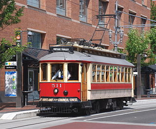
The Portland Vintage Trolley was a heritage streetcar service in Portland, Oregon, United States, that operated from 1991 to 2014. It operated on a portion of the MAX light rail system, and for a brief time also operated on the Portland Streetcar system, in downtown and nearby areas. Service was provided with replicas of a type of Brill streetcar, nicknamed the "Council Crest" cars, which last served Portland in 1950. The service was managed by Vintage Trolley Inc., a non-profit corporation, and the cars were owned and operated by TriMet, Portland's transit agency. For 18 of its 23 years, the service followed a 2.3-mile (3.7 km) section of what is now the MAX Blue Line, between Lloyd Center and the west end of downtown. In September 2009, the route was changed to a 1.5-mile (2.4 km) section of the MAX system, along the transit mall in downtown Portland, from Union Station to Portland State University (PSU).
The Portland Transit Mall is a 1.2-mile (1.9 km) public transit corridor that travels north–south through the center of downtown in Portland, Oregon, United States. It comprises a pair of one-way streets—6th Avenue for northbound traffic and 5th Avenue for southbound—along which two of three lanes are restricted to transit buses and light rail vehicles only. As of September 2022, the corridor is served by the Green, Orange, and Yellow lines of MAX Light Rail; Frequent Express; and over a dozen local bus routes, all of which are services of TriMet, the transit agency operating within the Oregon side of the Portland metropolitan area. C-Tran, the transit agency for Clark County, Washington, additionally serves it with two express bus routes—#105 I-5 Express and #164 Fisher’s Landing Express.
Tilikum Crossing, Bridge of the People is a cable-stayed bridge across the Willamette River in Portland, Oregon, United States. It was designed by TriMet, the Portland metropolitan area's regional transit authority, for its MAX Orange Line light rail passenger trains. The bridge also serves city buses and the Portland Streetcar, as well as bicycles, pedestrians, and emergency vehicles. Private cars and trucks are not permitted on the bridge. It is the first major bridge in the U.S. that was designed to allow access to transit vehicles, cyclists and pedestrians but not cars.
The transportation system of Oregon is a cooperation of complex systems of infrastructure.
The North South Line is a streetcar service of the Portland Streetcar system in Portland, Oregon, United States. Operated by Portland Streetcar, Inc. and TriMet, it travels approximately 4.1 miles (6.6 km) per direction from Northwest 23rd & Marshall to Southwest Lowell & Bond and serves 39 stations. The line connects Portland's Northwest District, Pearl District, downtown, Portland State University (PSU), and South Waterfront. It runs every day of the week between 15 and 18 hours per day and operates on headways of 15 to 20 minutes.
The A and B Loop is a streetcar circle route of the Portland Streetcar system in Portland, Oregon, United States. Operated by Portland Streetcar, Inc. and TriMet, it is made up of two separate services: the 6.1-mile (9.8 km) A Loop, which runs clockwise, and the 6.6-mile (10.6 km) B Loop, which runs counterclockwise. The route travels a loop between the east and west sides of the Willamette River by crossing the Broadway Bridge in the north and Tilikum Crossing in the south.
Frequent Express (FX) is a high-capacity bus service operated by TriMet in Portland, Oregon, United States. Operating as FX2–Division, the 15-mile (24 km) route runs east–west from 5th & Hoyt on the Portland Transit Mall in downtown Portland to Cleveland Avenue Park and Ride in Gresham via Division Street. It connects Portland City Center, Portland State University (PSU), South Waterfront, Southeast Portland, and central Gresham, with transfers to MAX Light Rail and the Portland Streetcar.
This page is based on this Wikipedia article Text is available under the CC BY-SA 4.0 license; additional terms may apply. Images, videos and audio are available under their respective licenses.