Transportation in Williamsburg, Virginia

Last updated

The city of Williamsburg, Virginia has a full range of transport facilities. Williamsburg is served by the Newport News/Williamsburg International Airport, and by two larger but more distant airports. The city is linked to several Interstate and State highways. A transport hub - the Williamsburg Transportation Center - serves bus and rail passengers. Motor traffic is restricted in the historic area, and the city as a whole is more "walkable" than the US norm. Cycling routes are also being provided.

Contents

Airports

Williamsburg is served by the Newport News/Williamsburg International Airport, in nearby Newport News, approximately 20 miles distant.

The Norfolk International Airport and Richmond International Airport, each located about 55 miles away via Interstate highways, are larger and offer considerably more flights. Williamsburg is roughly equidistant from these two airports. However, due to traffic concerns in crossing the harbor of Hampton Roads at the Hampton Roads Bridge-Tunnel, the Richmond airport is often a shorter driving time away.

The Williamsburg Jamestown Airport is a small general aviation airport located approximately 3 miles southwest of Williamsburg, that provides services for personal and charter aircraft, as well as related services (aviation goods, car rentals, etc.)

Highways

Williamsburg is located adjacent to Interstate 64 and U.S. Route 60, which connect the city with Richmond to the northwest and Norfolk to the southeast. State Route 199, officially named the Humelsine Parkway (after former Colonial Williamsburg President Carl Humelsine), surrounds the city in a semicircle. State Route 5 links the city with the James River Plantations along the north shore of the James River, Interstate 295 and Richmond. State Route 31 links the city to Jamestown and the toll-free Jamestown Ferry.

The Colonial Parkway provides a bucolic low-speed link between the points of the Historic Triangle which in addition to Colonial Williamsburg, includes Jamestown and Yorktown. It passes under the colonial-era "Restored Area" in a tunnel. With the exception of buses, commercial vehicles are not allowed on the Parkway. [1]

Public land transport

Williamsburg Transportation Center is an intermodal facility located in a restored Chesapeake and Ohio Railway station located within walking distance of Colonial Williamsburg's Historic Area, the College of William and Mary, and the downtown area. Williamsburg Transportation Center in Williamsburg Virginia 2-03-2008.jpg
Williamsburg Transportation Center is an intermodal facility located in a restored Chesapeake and Ohio Railway station located within walking distance of Colonial Williamsburg's Historic Area, the College of William and Mary, and the downtown area.

More comprehensively than many other U.S. destinations, Williamsburg offers good public transport alternatives for visitors and citizens, both getting there, and moving around locally. The area has both a central intermodal transportation center and an extensive public transit bus system prepared to serve local users and visitors.

Transportation center

The centrally-located Williamsburg Transportation Center is located near the Historic Area, the College of William and Mary, and the downtown area. Nearly all intercity and local rail and bus services use this Center. It is located in a restored building which was formerly a Chesapeake and Ohio Railway station, and affords easy access to the Colonial Williamsburg Visitor's Center.

Railroad

The city is served by several Amtrak trains a day, with direct service to Newport News, along the Virginia Peninsula to Richmond, and points along the Northeast Corridor from Washington DC through New York City to Boston.

A high-speed rail connection at Richmond to both the Northeast Corridor and the Southeast High Speed Rail Corridor are also under study. [2]

Long-distance bus

Intercity bus service is provided by Greyhound Lines (Carolina Trailways) and Hampton Roads Transit (HRT).

Greyhound bus loading at Williamsburg's Transportation Center. The intermodal services of trains, intercity buses, transit buses, taxicabs and rental cars offers exceptionally easy access to visitors Greyhound motorcoach at Williamsburg Transportation Center 2-03-2008.jpg
Greyhound bus loading at Williamsburg's Transportation Center. The intermodal services of trains, intercity buses, transit buses, taxicabs and rental cars offers exceptionally easy access to visitors

Local bus

The Transportation Center offers several modes of local transportation. Taxicabs and rental cars are also based there.

The community's public bus system, Williamsburg Area Transit Authority (WATA), has its central hub at the transportation center. A network of accessible transit bus routes serve the city, James City County, and most portions of York County adjacent to the Williamsburg area, with hourly service seven days a week, and half-hourly service on weekdays during peak travel hours. The routes operated by WATA include a loop around the College of William and Mary campus while classes are in session. The system also provides paratransit services and operates replica trolley buses at the Yorktown Riverfront attraction. [3] WATA connects with the much larger Hampton Roads Transit (HRT) (Routes 108 and 116) bus system at Lee Hall in northwestern Newport News and at the Williamsburg Transportation Center (HRT Route 121). HRT routes connect to many other cities to the east in Hampton Roads and Greyhound Lines bus routes serve a nationwide network.

A local bus company, Oleta Coach Lines, Inc., operates a weekly public bus route from the Williamsburg Transportation Center to several large shopping malls in the Hampton Roads area. The bus route runs from Williamsburg to Hampton, to Newport News then back to Williamsburg. This has been certified as a Public Convenience and Necessity bus route. [4]

Walking and cycling

Walking is a major mode of transportation in Williamsburg, with about a fifth of people walking to work between 2006 and 2010. [5] Walk Score, a website which algorithmically determines how friendly communities are to walkers, describes the city as "very walkable". [6]

With few exceptions, motorized traffic is not allowed on Duke of Gloucester Street, which passes through Colonial Williamsburg and the shopping district of Merchant's Square. There are bus stops and some parking areas located conveniently nearby, however. [7]

The city is also increasingly bicycle-friendly, having built 48 miles of bicycle facilities in the area since 1992. [8] Upon completion, the Virginia Capital Trail will provide a paved off-road path to Richmond for cyclists and pedestrians via the Colonial Parkway.

Related Research Articles

<span class="mw-page-title-main">York County, Virginia</span> County in Virginia, United States

York County is a county in the eastern part of the Commonwealth of Virginia, located in the Tidewater. As of the 2020 census, the population was 70,045. The county seat is the unincorporated town of Yorktown.

<span class="mw-page-title-main">Williamsburg, Virginia</span> Independent city in Virginia, United States

Williamsburg is an independent city in Virginia, United States. As of the 2020 census, it had a population of 15,425. Located on the Virginia Peninsula, Williamsburg is in the northern part of the Hampton Roads metropolitan area. It is bordered by James City County on the west and south and York County on the east.

<span class="mw-page-title-main">James City County, Virginia</span> County in Virginia, United States

James City County is a county located in the Commonwealth of Virginia. As of the 2020 census, the population was 78,254. Although politically separate from the county, the county seat is the adjacent independent city of Williamsburg.

<span class="mw-page-title-main">Yorktown, Virginia</span> Census-designated place in Virginia, United States

Yorktown is a census-designated place (CDP) in York County, Virginia. It is the county seat of York County, one of the eight original shires formed in colonial Virginia in 1682. Yorktown's population was 195 as of the 2010 census, while York County's population was 66,134 in the 2011 census estimate.

<span class="mw-page-title-main">Hampton Roads</span> Body of water and metropolitan area in the U.S. states of Virginia and North Carolina

<span class="mw-page-title-main">Virginia Peninsula</span> Peninsula in southeast Virginia, United States

The Virginia Peninsula is a peninsula in southeast Virginia, bounded by the York River, James River, Hampton Roads and Chesapeake Bay. It is sometimes known as the Lower Peninsula to distinguish it from two other peninsulas to the north, the Middle Peninsula and the Northern Neck.

<span class="mw-page-title-main">Colonial Parkway</span> Scenic parkway in Virginia

Colonial Parkway is a 23-mile (37 km) scenic parkway linking the three points of Virginia's Historic Triangle, Jamestown, Williamsburg, and Yorktown. It is part of the National Park Service's Colonial National Historical Park. Virginia's official state classification for the parkway is State Route 90003. With portions built between 1930 and 1957, it links the three communities via a roadway shielded from views of commercial development. The roadway is toll-free, is free of semi trucks, and has speed limits of around 35 to 45 mph. As a National Scenic Byway and All-American Road, it is also popular with tourists due to the James River and York River ends of the parkway.

<span class="mw-page-title-main">Historic Triangle</span> District in United States

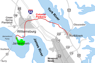
The Historic Triangle includes three historic colonial communities located on the Virginia Peninsula of the United States and is bounded by the York River on the north and the James River on the south. The points that form the triangle are Jamestown, Colonial Williamsburg, and Yorktown. They feature many restored attractions and are linked by the Colonial Parkway in James City and York counties, and the City of Williamsburg.

<span class="mw-page-title-main">Jamestown Ferry</span>

<span class="mw-page-title-main">Hampton Roads Transit</span>

Hampton Roads Transit (HRT), incorporated on October 1, 1999, began through the voluntary merger of PENTRAN on the Virginia Peninsula and TRT in South Hampton Roads and currently serves over 22 million annual passengers within its 369-square-mile (960 km2) service area around Hampton Roads. The purpose of the HRT is to provide reliable and efficient transportation service and facilities to the Hampton Roads community. In 2022, the system had a ridership of 6,750,200, or about per weekday as of the second quarter of 2023.

<span class="mw-page-title-main">Grove, Virginia</span> Human settlement in Virginia, United States of America

Grove is an unincorporated community in the southeastern portion of James City County in the Virginia Peninsula subregion of Virginia in the United States. It is located in the center of the Historic Triangle of Colonial Virginia, communities linked by the Colonial Parkway. This area is one of the busiest tourist destinations in the world.

<span class="mw-page-title-main">Lee Hall, Virginia</span> Neighborhood in Virginia, United States

Lee Hall is an unincorporated town located in the extreme western portion of the independent city of Newport News in the Commonwealth of Virginia in the United States.

<span class="mw-page-title-main">Transportation in Virginia</span> Overview of land sea and air transport systems in Virginia

Transportation in the Commonwealth of Virginia is by land, sea and air. Virginia's extensive network of highways and railroads were developed and built over a period almost 400 years, beginning almost immediately after the founding of Jamestown in 1607, and often incorporating old established trails of the Native Americans.

<span class="mw-page-title-main">Transportation in Richmond, Virginia</span>

Transportation in Richmond, Virginia and its immediate surroundings include land, sea and air modes. This article includes the independent city and portions of the contiguous counties of Henrico and Chesterfield. While almost all of Henrico County would be considered part of the Richmond area, southern and eastern portions of Chesterfield adjoin the three smaller independent cities of Petersburg, Hopewell, and Colonial Heights, collectively commonly called the Tri-Cities area. A largely rural section of southwestern Chesterfield may be considered not a portion of either suburban area.

<span class="mw-page-title-main">Virginia State Route 143</span> State highway in Virginia

State Route 143 is a primary state highway in the U.S. state of Virginia. The state highway runs 35.39 miles (56.95 km) from Camp Peary near Williamsburg east to U.S. Route 258 at Fort Monroe in Hampton. SR 143 is a major local thoroughfare on the Virginia Peninsula portion of the Hampton Roads metropolitan area. The state highway is named Merrimac Trail through the independent city of Williamsburg and adjacent portions of York County and James City County. SR 143 follows Jefferson Avenue through the city of Newport News from the Williamsburg area past Virginia Peninsula Regional Jail to near Downtown Newport News. The state highway, which mostly runs northwest–southeast, heads northeast from Newport News, serving as one highway connecting the downtown areas of Newport News and Hampton. SR 143 parallels both US 60 and Interstate 64 (I-64) extensively, and sometimes very closely, throughout its course. The state highway also runs concurrently with US 60 in Hampton and with US 17 in Newport News.

<span class="mw-page-title-main">Williamsburg Area Transit Authority</span>

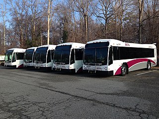
Williamsburg Area Transit Authority (WATA) is a multi-jurisdiction transportation agency providing transit bus and ADA Paratransit services in the City of Williamsburg, James City County, York County in the Historic Triangle area and Surry County, VA of the Virginia Peninsula subregion of Hampton Roads in southeastern Virginia.

<span class="mw-page-title-main">U.S. Route 60 in Virginia</span> Section of U.S. Numbered Highway in Virginia, United States

U.S. Route 60 (US 60) in the Commonwealth of Virginia runs 303 miles (488 km) west to east through the central part of the state, generally close to and paralleling the Interstate 64 corridor, except for the crossing of the Blue Ridge Mountains, and in the South Hampton Roads area.

<span class="mw-page-title-main">Williamsburg Transportation Center</span> Intermodal transportation hub in Williamsburg, Virginia

Williamsburg Transportation Center is an intermodal transit station in Williamsburg, Virginia. Operated by the Williamsburg Area Transit Authority, it also serves Amtrak's Northeast Regional train as well as Greyhound Lines and Hampton Roads Transit intercity buses. The transportation center was formerly a Chesapeake and Ohio Railway (C&O) passenger station.

Located in the southeastern corner of the state, Norfolk is economically and culturally important to Virginia. A variety of transportation modes have developed around the city's importance and somewhat unusual geography.

<span class="mw-page-title-main">Transportation in Hampton Roads</span>

Historically, the harbor was the key to the Hampton Roads area's growth, both on land and in water-related activities and events. Ironically, the harbor and its tributary waterways were both important transportation conduits and obstacles to other land-based commerce and travel. For hundreds of years, state and community leaders have worked to develop solutions to accommodate both.

References

  1. Colonial National Historical Park website
  2. "Southeast High Speed Rail". Southeast High Speed Rail. Retrieved October 15, 2007.
  3. Williamsburg Area Transit Authority
  4. Oleta Coach Lines
  5. "Selected Economic Characteristics: 2006-2010 American Community Survey 5-Year Estimates". U.S. Census Bureau. Retrieved July 12, 2012.[ dead link ]
  6. "Walk Score of Williamsburg VA" . Retrieved July 12, 2012.
  7. Duke of Gloucester Street
  8. "BikeWalk to Work Day 2012". City of Williamsburg. Archived from the original on February 12, 2011. Retrieved July 12, 2012.