
An earthquake is the shaking of the surface of the Earth resulting from a sudden release of energy in the Earth's lithosphere that creates seismic waves. Earthquakes can range in intensity, from those that are so weak that they cannot be felt, to those violent enough to propel objects and people into the air, damage critical infrastructure, and wreak destruction across entire cities. The seismic activity of an area is the frequency, type, and size of earthquakes experienced over a particular time. The seismicity at a particular location in the Earth is the average rate of seismic energy release per unit volume. The word tremor is also used for non-earthquake seismic rumbling.

Seismology is the scientific study of earthquakes and the propagation of elastic waves through the Earth or other planetary bodies. It also includes studies of earthquake environmental effects such as tsunamis as well as diverse seismic sources such as volcanic, tectonic, glacial, fluvial, oceanic, atmospheric, and artificial processes such as explosions. A related field that uses geology to infer information regarding past earthquakes is paleoseismology. A recording of Earth motion as a function of time is called a seismogram. A seismologist is a scientist who does research in seismology.
A seismic wave is a wave of acoustic energy that travels through the Earth or another planetary body. It can result from an earthquake, volcanic eruption, magma movement, a large landslide, and a large man-made explosion that produces low-frequency acoustic energy. Seismic waves are studied by seismologists, who record the waves using seismometers, hydrophones, or accelerometers. Seismic waves are distinguished from seismic noise, which is persistent low-amplitude vibration arising from a variety of natural and anthropogenic sources.

The epicenter, epicentre, or epicentrum in seismology is the point on the Earth's surface directly above a hypocenter or focus, the point where an earthquake or an underground explosion originates.

The Mohorovičić discontinuity, usually referred to as the Moho discontinuity, Moho boundary, or just Moho, is the boundary between the Earth's crust and the mantle. It is defined by the distinct change in velocity of seismic waves as they pass through changing densities of rock.
Seismic tomography is a technique for imaging the subsurface of the Earth with seismic waves produced by earthquakes or explosions. P-, S-, and surface waves can be used for tomographic models of different resolutions based on seismic wavelength, wave source distance, and the seismograph array coverage. The data received at seismometers are used to solve an inverse problem, wherein the locations of reflection and refraction of the wave paths are determined. This solution can be used to create 3D images of velocity anomalies which may be interpreted as structural, thermal, or compositional variations. Geoscientists use these images to better understand core, mantle, and plate tectonic processes.

Andrija Mohorovičić was a Croatian geophysicist. He is best known for the eponymous Mohorovičić discontinuity and is considered one of the founders of modern seismology.

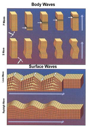
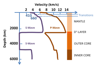
A P wave is one of the two main types of elastic body waves, called seismic waves in seismology. P waves travel faster than other seismic waves and hence are the first signal from an earthquake to arrive at any affected location or at a seismograph. P waves may be transmitted through gases, liquids, or solids.

The core–mantle boundary (CMB) of Earth lies between the planet's silicate mantle and its liquid iron-nickel outer core. This boundary is located at approximately 2,891 km depth beneath Earth's surface. The boundary is observed via the discontinuity in seismic wave velocities at that depth due to the differences between the acoustic impedances of the solid mantle and the molten outer core. P-wave velocities are much slower in the outer core than in the deep mantle while S-waves do not exist at all in the liquid portion of the core. Recent evidence suggests a distinct boundary layer directly above the CMB possibly made of a novel phase of the basic perovskite mineralogy of the deep mantle named post-perovskite. Seismic tomography studies have shown significant irregularities within the boundary zone and appear to be dominated by the African and Pacific Large Low-Shear-Velocity Provinces (LLSVP).
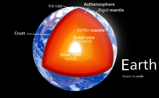
Earth's inner core is the innermost geologic layer of planet Earth. It is primarily a solid ball with a radius of about 1,220 km (760 mi), which is about 20% of Earth's radius or 70% of the Moon's radius.
The primary purpose of a seismometer is to locate the initiating points of earthquake epicenters. The secondary purpose, of determining the 'size' or Moment magnitude scale must be calculated after the precise location is known.

The EarthScope project was an National Science Foundation (NSF) funded earth science program that, from 2003-2018, used geological and geophysical techniques to explore the structure and evolution of the North American continent and to understand the processes controlling earthquakes and volcanoes. The project had three components: USArray, the Plate Boundary Observatory, and the San Andreas Fault Observatory at Depth. Organizations associated with the project included UNAVCO, the Incorporated Research Institutions for Seismology (IRIS), Stanford University, the United States Geological Survey (USGS) and National Aeronautics and Space Administration (NASA). Several international organizations also contributed to the initiative. EarthScope data are publicly accessible.
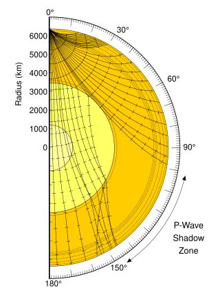
A seismic shadow zone is an area of the Earth's surface where seismographs cannot detect direct P waves and/or S waves from an earthquake. This is due to liquid layers or structures within the Earth's surface. The most recognized shadow zone is due to the core-mantle boundary where P waves are refracted and S waves are stopped at the liquid outer core; however, any liquid boundary or body can create a shadow zone. For example, magma reservoirs with a high enough percent melt can create seismic shadow zones.
Seismic magnitude scales are used to describe the overall strength or "size" of an earthquake. These are distinguished from seismic intensity scales that categorize the intensity or severity of ground shaking (quaking) caused by an earthquake at a given location. Magnitudes are usually determined from measurements of an earthquake's seismic waves as recorded on a seismogram. Magnitude scales vary on what aspect of the seismic waves are measured and how they are measured. Different magnitude scales are necessary because of differences in earthquakes, the information available, and the purposes for which the magnitudes are used.
The receiver function technique is a way to image the structure of the Earth and its internal boundaries by using the information from teleseismic earthquakes recorded at a three-component seismograph.
The low-velocity zone (LVZ) occurs close to the boundary between the lithosphere and the asthenosphere in the upper mantle. It is characterized by unusually low seismic shear wave velocity compared to the surrounding depth intervals. This range of depths also corresponds to anomalously high electrical conductivity. It is present between about 80 and 300 km depth. This appears to be universally present for S waves, but may be absent in certain regions for P waves. A second low-velocity zone has been detected in a thin ≈50 km layer at the core-mantle boundary. These LVZs may have important implications for plate tectonics and the origin of the Earth's crust.

Karl Bernhard Zoeppritz was a German geophysicist who made important contributions to seismology, in particular the formulation of the Zoeppritz equations.

The lithosphere–asthenosphere boundary represents a mechanical difference between layers in Earth's inner structure. Earth's inner structure can be described both chemically and mechanically. The lithosphere–asthenosphere boundary lies between Earth's cooler, rigid lithosphere and the warmer, ductile asthenosphere. The actual depth of the boundary is still a topic of debate and study, although it is known to vary according to the environment.
The upper mantle of Earth is a very thick layer of rock inside the planet, which begins just beneath the crust and ends at the top of the lower mantle at 670 km (420 mi). Temperatures range from approximately 500 K at the upper boundary with the crust to approximately 1,200 K at the boundary with the lower mantle. Upper mantle material that has come up onto the surface comprises about 55% olivine, 35% pyroxene, and 5 to 10% of calcium oxide and aluminum oxide minerals such as plagioclase, spinel, or garnet, depending upon depth.
Annie Souriau is a French seismologist from the commune of Saint-Cloud Paris. She is primarily known for her research into Earth's inner and outer cores, specifically her work examining seismic activity within and around the Pyrenees mountains. Through her and her colleague's research and studies, she has made notable advances to how we understand the inner workings of the earth's core while also winning countless awards in the process.

