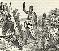
The treaty signing took place on the banks of the Tallapoosa River near the present city of Alexander City, Alabama. The U.S. force, led by General Andrew Jackson, consisted mainly of the West Tennessee Militia and 39th United States Infantry, allied with several groups of Cherokee and Lower Creek friendly to the American side. The Upper Creek were led by Chief Menawa, who fled with hundreds of survivors into Florida, where they allied with the Seminole. The surrender ended the Creek War, which the United States was fighting simultaneously with the War of 1812.[2]
By the terms of the treaty, the Creek were forced to cede 23million acres (93,000km2) of their territory (their remaining land in Georgia and much of central Alabama) to the United States government.[2][3][4]
Results
The victory at Horseshoe Bend and the signing of the treaty freed Jackson to continue southwest to Louisiana, where he defeated the British forces at the Battle of New Orleans. His victories against Native American forces and then his victory at New Orleans won Jackson an enormous amount of popular support, creating a public image that would contribute to his success in the 1828 presidential election.[3] Appeals to lessen the demands to forfeit huge parcels of Creek lands by the friend and ally of Jackson, Chief Shelocta, went unheeded in the signing of the treaty.[5][6]
This section is a candidate for copying over to Wikisource. If the section can be edited into encyclopedic content, rather than merely a copy of the source text, please do so and remove this message. Otherwise, you can help by formatting it per the Wikisource guidelines in preparation for the duplication.
Articles of agreement and capitulation, made and concluded this ninth day of August, one thousand eight hundred and fourteen, between major general Andrew Jackson, on behalf of the President of the United States of America, and the chiefs, deputies, and warriors of the Creek Nation.
WHEREAS an unprovoked, inhuman, and sanguinary war, waged by the hostile Creeks against the United States, hath been repelled, prosecuted and determined, successfully, on the part of the said States, in conformity with principles of national justice and honorable warfare–And whereas consideration is due to the rectitude of proceeding dictated by instructions relating to the re-establishment of peace: Be it remembered, that prior to the conquest of that part of the Creek nation hostile to the United States, numberless aggressions had been committed against the peace, the property, and the lives of citizens of the United States, and those of the Creek nation in amity with her, at the mouth of Duck river, Fort Mimms, and elsewhere, contrary to national faith, and the regard due to an article of the treaty concluded at New-York, in the year seventeen hundred ninety, between the two nations: That the United States, previously to the perpetration of such outrages, did, in order to ensure future amity and concord between the Creek nation and the said states, in conformity with the stipulations of former treaties, fulfill, with punctuality and good faith, her engagements to the said nation: that more than two-thirds of the whole number of chiefs and warriors of the Creek nation, disregarding the genuine spirit of existing treaties, suffered themselves to be instigated to violations of their national honor, and the respect due to a part of their own nation faithful to the United States and the principles of humanity, by impostures [impostors,] denominating themselves Prophets, and by the duplicity and misrepresentation of foreign emissaries, whose governments are at war, open or understood, with the United States. Wherefore,
1st–The United States demand an equivalent for all expenses incurred in prosecuting the war to its termination, by a cession of all the territory belonging to the Creek nation within the territories of the United States, lying west, south, and south-eastwardly, of a line to be run and described by persons duly authorized and appointed by the President of the United States:
Beginn at a point on the eastern bank of the Coosa river, where the south boundary line of the Cherokee nation crosses the same; running from thence down the said Coosa river with its eastern bank according to its various meanders to a point one mile above the mouth of Cedar creek, at Fort Williams, thence east two miles, thence south two miles, thence west to the eastern bank of the said Coosa river, thence down the eastern bank thereof according to its various meanders to a point opposite the upper end of the great falls, (called by the natives Woetumka,) thence east from a true meridian line to a point due north of the mouth of Ofucshee, thence south by a like meridian line to the mouth of Ofucshee on the south side of the Tallapoosa river, thence up the same, according to its various meanders, to a point where a direct course will cross the same at the distance of ten miles from the mouth thereof, thence a direct line to the mouth of Summochico creek, which empties into the Chatahouchie river on the east side thereof below the Eufaulau town, thence east from a true meridian line to a point which shall intersect the line now dividing the lands claimed by the said Creek nation from those claimed and owned by the state of Georgia: Provided, nevertheless, that where any possession of any chief or warrior of the Creek nation, who shall have been friendly to the United States during the war and taken an active part therein, shall be within the territory ceded by these articles to the United States, every such person shall be entitled to a reservation of land within the said territory of one mile square, to include his improvements as near the centre thereof as may be, which shall inure to the said chief or warrior, and his descendants, so long as he or they shall continue to occupy the same, who shall be protected by and subject to the laws of the United States; but upon the voluntary abandonment thereof, by such possessor or his descendants, the right of occupancy or possession of said lands shall devolve to the United States, and be identified with the right of property ceded hereby.
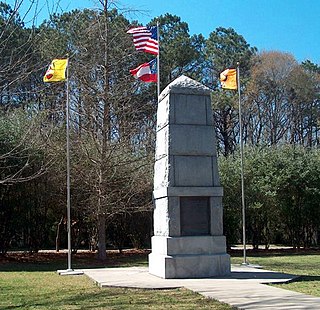
A historical marker near Union Springs in Bullock County, Alabama shows the Indian Territory boundary line created by the Treaty of Fort Jackson.
2nd–The United States will guarantee to the Creek nation, the integrity of all their territory eastwardly and northwardly of the said line to be run and described as mentioned in the first article.
3d–The United States demand, that the Creek nation abandon all communication, and cease to hold any intercourse with any British or Spanish post, garrison, or town; and that they shall not admit among them, any agent or trader, who shall not derive authority to hold commercial, or other intercourse with them, by license from the President or authorized agent of the United States.
4th–The United States demand an acknowledgment of the right to establish military posts and trading houses, and to open roads within the territory, guaranteed to the Creek nation by the second article, and a right to the free navigation of all its waters.
5th–The United States demand, that a surrender be immediately made, of all the persons and property, taken from the citizens of the United States, the friendly part of the Creek nation, the Cherokee, Chickasaw, and Choctaw nations, to the respective owners; and the United States will cause to be immediately restored to the formerly hostile Creeks, all the property taken from them since their submission, either by the United States, or by any Indian nation in amity with the United States, together with all the prisoners taken from them during the war.
6th–The United States demand the caption and surrender of all the prophets and instigators of the war, whether foreigners or natives, who have not submitted to the arms of the United States, and become parties to these articles of capitulation, if ever they shall be found within the territory guaranteed to the Creek nation by the second article.
7th–The Creek nation being reduced to extreme want, and not at present having the means of subsistence, the United States, from motives of humanity, will continue to furnish gratuitously the necessaries of life, until the crops of corn can be considered competent to yield the nation a supply, and will establish trading houses in the nation, at the discretion of the President of the United States, and at such places as he shall direct, to enable the nation, by industry and economy, to procure clothing.
8th–A permanent peace shall ensue from the date of these presents forever, between the Creek nation and the United States, and between the Creek nation and the Cherokee, Chickasaw, and Choctaw nations.
9th–If in running east from the mouth of Summochico creek, it shall so happen that the settlement of the Kennards, fall within the lines of the territory hereby ceded, then, and in that case, the line shall be run east on a true meridian to Kitchofoonee creek, thence down the middle of said creek to its junction with Flint River, immediately below the Oakmulgee town, thence up the middle of Flint river to a point due east of that at which the above line struck the Kitchofoonee creek, thence east to the old line herein before mentioned, to wit: the line dividing the lands claimed by the Creek nation, from those claimed and owned by the state of Georgia. The parties to these presents, after due consideration, for themselves and their constituents, agree to ratify and confirm the preceding articles, and constitute them the basis of a permanent peace between the two nations; and they do hereby solemnly bind themselves, and all the parties concerned and interested, to a faithful performance of every stipulation contained therein.[8]
In testimony whereof, they have hereunto, interchangeably, set their hands and affixed their seals, the day and date above written.
George Mayfield, Alexander Curnels, George Lovett, public interpreters
Related Research Articles
The Muscogee, also known as the Mvskoke, Muscogee Creek or just Creek, and the Muscogee Creek Confederacy, are a group of related Indigenous peoples of the Southeastern Woodlands in the United States. Their historical homelands are in what now comprises southern Tennessee, much of Alabama, western Georgia and parts of northern Florida.
The Trail of Tears was an ethnic cleansing and forced displacement of approximately 60,000 people of the "Five Civilized Tribes" between 1830 and 1850 by the United States government. As part of the Indian removal, members of the Cherokee, Muscogee (Creek), Seminole, Chickasaw, and Choctaw nations were forcibly removed from their ancestral homelands in the Southeastern United States to newly designated Indian Territory west of the Mississippi River after the passage of the Indian Removal Act in 1830. The Cherokee removal in 1838 was brought on by the discovery of gold near Dahlonega, Georgia, in 1828, resulting in the Georgia Gold Rush.
The Battle of Horseshoe Bend, was fought during the War of 1812 in the Mississippi Territory, now central Alabama. On March 27, 1814, United States forces and Indian allies under Major General Andrew Jackson defeated the Red Sticks, a part of the Creek Indian tribe who opposed American expansion, effectively ending the Creek War.
John Ross was the Principal Chief of the Cherokee Nation from 1828 to 1866; he served longer in that position than any other person. Described as the Moses of his people, Ross influenced the nation through such tumultuous events as the relocation to Indian Territory and the American Civil War.
The Creek War, was a regional conflict between opposing Native American factions, European powers, and the United States during the early 19th century. The Creek War began as a conflict within the tribes of the Muscogee, but the United States quickly became involved. British traders and Spanish colonial officials in Florida supplied the Red Sticks with weapons and equipment due to their shared interest in preventing the expansion of the United States into regions under their control.
Major Ridge, The Ridge was a Cherokee leader, a member of the tribal council, and a lawmaker. As a warrior, he fought in the Cherokee–American wars against American frontiersmen. Later, Major Ridge led the Cherokee in alliances with General Andrew Jackson and the United States in the Creek and Seminole wars of the early 19th century.
The Coosa River is a tributary of the Alabama River in the U.S. states of Alabama and Georgia. The river is about 280 miles (450 km) long.
Red Sticks —the name deriving from the red-painted war clubs of some Native American Creek—refers to an early 19th century traditionalist faction of Muscogee Creek people in the Southeastern United States. Made up mostly of Creek of the Upper Towns that supported traditional leadership and culture, as well as the preservation of communal land for cultivation and hunting, the Red Sticks arose at a time of increasing pressure on Creek territory by European American settlers. Creek of the Lower Towns were closer to the settlers, had more mixed-race families, and had already been forced to make land cessions to the Americans. In this context, the Red Sticks led a resistance movement against European American encroachment and assimilation, tensions that culminated in the outbreak of the Creek War in 1813. Initially a civil war among the Creek, the conflict drew in United States state forces while the nation was already engaged in the War of 1812 against the British.
The Honey War was a bloodless territorial dispute in 1839 between Iowa Territory and Missouri over their border.
John Ridge, born Skah-tle-loh-skee, was from a prominent family of the Cherokee Nation, then located in present-day Georgia. He went to Cornwall, Connecticut, to study at the Foreign Mission School. He met Sarah Bird Northup, of a New England Yankee family, and they married in 1824. Soon after their return to New Echota in 1825, Ridge was chosen for the Cherokee National Council and became a leader in the tribe.
Three agreements, each known as a Treaty of Hopewell, were signed between representatives of the Congress of the United States and the Cherokee, Choctaw, and Chickasaw peoples. They were negotiated and signed at the Hopewell plantation in South Carolina over 45 days during the winter of 1785–86.
This Fort Bridger Treaty Council of 1868, was also known as the Great Treaty Council, was a council that developed the Fort Bridger Treaty of 1868. The Shoshone, also referred to as the Shoshoni or Snake, were the main American Indian group affected by this treaty. The event itself is significant because it was the last treaty council which dealt with establishing a reservation. After that council, executive Orders were used to establish reservations.
John C. Sullivan was a surveyor who established the Indian Boundary Line and the Sullivan Line which were to form the boundary between Native Americans and white settlers in Indian Territory from Iowa to Texas.
The Treaty of Doak's Stand was signed on October 18, 1820 between the United States and the Choctaw Indian tribe. Based on the terms of the accord, the Choctaw agreed to give up approximately one-half of their remaining Choctaw homeland. In October 1820, Andrew Jackson and Thomas Hinds were sent as commissioners who represented the United States to negotiate a treaty to surrender a large portion of Choctaw country in Mississippi. They met with tribal representatives at Doak's Stand on the Natchez Trace. They met with the chiefs Pushmataha, Mushulatubbee, and Apuckshunubbee, who represented the three major regional divisions of the Choctaw. Chiefs of the towns and other prominent men accompanied them, such as Colonel Silas Dinsmoor.
The Treaty of Big Tree was a formal treaty signed in 1797 between the Seneca Nation and the United States, in which the Seneca relinquished their rights to nearly all of their traditional homeland in New York State—nearly 3.5 million acres. In the 1788 Phelps and Gorham Purchase, the Haudenosaunee (Iroquois) had previously sold rights to their land between Seneca Lake and the Genesee River. The Treaty of Big Tree signed away their rights to all their territory west of the Genesee River except 12 small tracts of land for $100,000 and other considerations. The money was not paid directly to the tribe, but was to be invested in shares of the Bank of the United States, and to be paid out to the Senecas in annual earnings of up to six percent, or $6,000 a year, on the bank stock.
The Chickamauga Cherokee were a Native American group that separated from the greater body of the Cherokee during the American Revolutionary War and up to the early 1800s.
The Treaty of Turkeytown, also known as the Treaty with the Cherokee and the Treaty of Chickasaw Council House (Cherokee) was negotiated on 14 September 1816, between delegates of the former Cherokee Nation on the one part and Major General Andrew Jackson, General David Meriwether and Jesse Franklin, Esq., who served as agents of the United States in the capacity of "commissioners plenipotentiary", on the other part. Conducted following the Creek War, the initial meeting was held at the Chickasaw Council House and stipulated a further meeting on 28 September 1816, to be conducted at "Turkey's Town", on the Coosa River, near the present day town of Centre, in Cherokee County, Alabama. The treaty was ratified by the Cherokee Nation at Turkeytown on 4 October 1816, and signed by Pathkiller, then Principal Chief of the Cherokee Nation.
An Organic Act is a generic name for a statute used by the United States Congress to describe a territory, in anticipation of being admitted to the Union as a state. Because of Oklahoma's unique history an explanation of the Oklahoma Organic Act needs a historic perspective. In general, the Oklahoma Organic Act may be viewed as one of a series of legislative acts, from the time of Reconstruction, enacted by Congress in preparation for the creation of a united State of Oklahoma. The Organic Act created Oklahoma Territory, and Indian Territory that were Organized incorporated territories of the United States out of the old "unorganized" Indian Territory. The Oklahoma Organic Act was one of several acts whose intent was the assimilation of the tribes in Oklahoma and Indian Territories through the elimination of tribes' communal ownership of property.
Lovely County was a county that existed from October 31, 1827, to 1828 in the Arkansas Territory.
The Jacob Brown Grant Deeds, also known more simply as the Nolichucky Grants, were transactions for the sale of land by the Cherokee Nation to Jacob Brown. The transaction occurred at Sycamore Shoals on the Watauga River on March 25, 1775. The Jacob Brown grants were for two large tracts along the Nolichucky River some of which had been previously leased from the Cherokee.
This page is based on this Wikipedia article Text is available under the CC BY-SA 4.0 license; additional terms may apply. Images, videos and audio are available under their respective licenses.