Treaty of 1803
The United States was represented by William Henry Harrison, the Governor of the Indiana Territory. Harrison had been granted authority to settle the American claim to the Vincennes tract by President Thomas Jefferson. The Vincennes tract had been purchased by the Kingdom of France from the Piankeshaw, a Wea tribe, around 1740. The tract was ceded to Great Britain as part of the peace settlement after the French and Indian War. George Rogers Clark captured the territory from the British in the American Revolutionary War, and the United States claimed the tract by right of conquest. In 1802, the government surveyor Thomas Freeman, began a survey of the land, called "Freeman's Lines and Corners". The survey led to objections from some of the native tribes as to the exact boundaries, and extent of the tract. Jefferson decided the best solution would be open talks with the tribes and compensate them for their claims on the land. [1]
The Vincennes tract was a parcel of land that lay rectangular across the Wabash River. The majority of the land lay on the east bank, but a small parcel was also included along the west bank. The fortified town of Vincennes, an old French trading post, was the primary settlement in the area. In total, the tract contained about 1,600,000 acres (2,500 sq mi; 6,500 km2) of land. [1] The negotiations were successful and in exchange for compensation, the tribes recognized the American ownership of the tract.

The Miami are a Native American nation originally speaking one of the Algonquian languages. Among the peoples known as the Great Lakes tribes, they occupied territory that is now identified as north-central Indiana, southwest Michigan, and western Ohio. The Miami were historically made up of several prominent subgroups, including the Piankeshaw, Wea, Pepikokia, Kilatika, Mengakonkia, and Atchakangouen. In modern times, Miami is used more specifically to refer to the Atchakangouen. By 1846, most of the Miami had been forcefully displaced to Indian Territory. The Miami Tribe of Oklahoma are the federally recognized tribe of Miami Indians in the United States. The Miami Nation of Indiana, a nonprofit organization of self-identified descendants of Miamis who were exempted from removal, have unsuccessfully sought separate recognition.

Vincennes is a city in and the county seat of Knox County, Indiana, United States. It is located on the lower Wabash River in the southwestern part of the state, nearly halfway between Evansville and Terre Haute. Founded in 1732 by French fur traders, notably François-Marie Bissot, Sieur de Vincennes, for whom the Fort was named, Vincennes is the oldest continually inhabited European settlement in Indiana and one of the oldest settlements west of the Appalachians.

The Northwest Territory, also known as the Old Northwest and formally known as the Territory Northwest of the River Ohio, was formed from unorganized western territory of the United States after the American Revolution. Established in 1787 by the Congress of the Confederation through the Northwest Ordinance, it was the nation's first post-colonial organized incorporated territory.

The Treaty of Greenville, also known to Americans as the Treaty with the Wyandots, etc., but formally titled A treaty of peace between the United States of America, and the tribes of Indians called the Wyandots, Delawares, Shawanees, Ottawas, Chippewas, Pattawatimas, Miamis, Eel Rivers, Weas, Kickapoos, Piankeshaws, and Kaskaskias was a 1795 treaty between the United States and indigenous nations of the Northwest Territory, including the Wyandot and Delaware peoples, that redefined the boundary between indigenous peoples' lands and territory for European American community settlement.

The Indiana Territory, officially the Territory of Indiana, was created by an organic act that President John Adams signed into law on May 7, 1800, to form an organized incorporated territory of the United States that existed from July 4, 1800, to December 11, 1816, when the remaining southeastern portion of the territory was admitted to the Union as the state of Indiana. The territory originally contained approximately 259,824 square miles (672,940 km2) of land, but its size was decreased when it was subdivided to create the Michigan Territory (1805) and the Illinois Territory (1809). The Indiana Territory was the first new territory created from lands of the Northwest Territory, which had been organized under the terms of the Northwest Ordinance of 1787. The territorial capital was the settlement around the old French fort of Vincennes on the Wabash River, until transferred to Corydon near the Ohio River in 1813.

Tecumseh's War or Tecumseh's Rebellion was a conflict between the United States and Tecumseh's Confederacy, led by the Shawnee leader Tecumseh in the Indiana Territory. Although the war is often considered to have climaxed with William Henry Harrison's victory at the Battle of Tippecanoe in 1811, Tecumseh's War essentially continued into the War of 1812 and is frequently considered a part of that larger struggle. The war lasted for two more years, until 1813, when Tecumseh and his second-in-command, Roundhead, died fighting Harrison's Army of the Northwest at the Battle of the Thames in Upper Canada, near present-day Chatham, Ontario, and his confederacy disintegrated. Tecumseh's War is viewed by some academic historians as the final conflict of a longer-term military struggle for control of the Great Lakes region of North America, encompassing a number of wars over several generations, referred to as the Sixty Years' War.

Grouseland, the William Henry Harrison Mansion and Museum, is a National Historic Landmark important for its Federal-style architecture and role in American history. The two-story, red brick home was built between 1802 and 1804 in Vincennes, Indiana, for William Henry Harrison (1773–1841) during his tenure from 1801 to 1812 as the first governor of the Indiana Territory. The residence was completed in 1804, and Harrison reportedly named it Grouseland due to the abundance of grouse in the area.

George Rogers Clark was an American military officer and surveyor from Virginia who became the highest-ranking Patriot military officer on the northwestern frontier during the Revolutionary War. He served as leader of the Virginia militia in Kentucky throughout much of the war. He is best known for his captures of Kaskaskia in 1778 and Vincennes in 1779 during the Illinois campaign, which greatly weakened British influence in the Northwest Territory and earned Clark the nickname of "Conqueror of the Old Northwest". The British ceded the entire Northwest Territory to the United States in the 1783 Treaty of Paris.
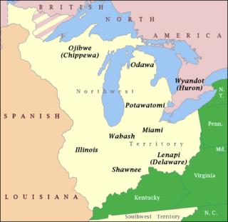
The Wabash Confederacy, also referred to as the Wabash Indians or the Wabash tribes, was a number of 18th century Native American villagers in the area of the Wabash River in what are now the U.S. states of Illinois, Indiana, and Ohio. The Wabash Indians were primarily the Miami, Weas and Piankashaws, but also included Kickapoos, Mascoutens, and others. In that time and place, Native American tribes were smaller political units, and the villages along the Wabash were multi-tribal settlements with no centralized government. The confederacy, then, was a loose alliance of influential village leaders.

The Wea were a Miami-Illinois-speaking Native American tribe originally located in western Indiana. Historically, they were described as either being closely related to the Miami Tribe or a sub-tribe of Miami.

William Wells, also known as Apekonit, was the son-in-law of Chief Little Turtle of the Miami. He fought for the Miami in the Northwest Indian War. During the course of that war, he became a United States Army officer, and also served in the War of 1812.

The Treaty of St. Mary's may refer to one of six treaties concluded in fall of 1818 between the United States and Natives of central Indiana regarding purchase of Native land. The treaties were
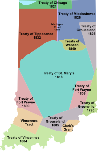
The Treaty of Fort Wayne, sometimes called the Ten O'clock Line Treaty or the Twelve Mile Line Treaty, is an 1809 treaty that obtained 29,719,530 acres of Native American land for the settlers of Illinois and Indiana. The negotiations primarily involved the Delaware tribe but included other tribes as well. However, the negotiations excluded the Shawnee, who were minor inhabitants of the area and had previously been asked to leave by Miami War Chief Little Turtle. Territorial Governor William Henry Harrison negotiated the treaty with the tribes. The treaty led to a war with the United States begun by Shawnee leader Tecumseh and other dissenting tribesmen in what came to be called "Tecumseh's War".
The Piankeshaw, Piankashaw or Pianguichia were members of the Miami tribe who lived apart from the rest of the Miami nation, therefore they were known as Peeyankihšiaki. When European settlers arrived in the region in the 1600s, the Piankeshaw lived in an area along the south central Wabash River that now includes western Indiana and Illinois. Their territory was to the north of Kickapoo and the south of the Wea. They were closely allied with the Wea, another group of Miamis. The Piankashaw were living along the Vermilion River in 1743.

During the 18th and early 19th centuries, the French, British and U.S. forces built and occupied a number of forts at Vincennes, Indiana. These outposts commanded a strategic position on the Wabash River. The names of the installations were changed by the various ruling parties, and the forts were considered strategic in the French and Indian War, the American Revolutionary War, the Northwest Indian War and the War of 1812. The last fort was abandoned in 1816.
Indian removals in Indiana followed a series of the land cession treaties made between 1795 and 1846 that led to the removal of most of the native tribes from Indiana. Some of the removals occurred prior to 1830, but most took place between 1830 and 1846. The Lenape (Delaware), Piankashaw, Kickapoo, Wea, and Shawnee were removed in the 1820s and 1830s, but the Potawatomi and Miami removals in the 1830s and 1840s were more gradual and incomplete, and not all of Indiana's Native Americans voluntarily left the state. The most well-known resistance effort in Indiana was the forced removal of Chief Menominee and his Yellow River band of Potawatomi in what became known as the Potawatomi Trail of Death in 1838, in which 859 Potawatomi were removed to Kansas and at least forty died on the journey west. The Miami were the last to be removed from Indiana, but tribal leaders delayed the process until 1846. Many of the Miami were permitted to remain on land allotments guaranteed to them under the Treaty of St. Mary's (1818) and subsequent treaties.
The Treaty of Grouseland was an agreement negotiated by Governor William Henry Harrison of the Indiana Territory on behalf of the government of the United States of America with Native American leaders, including Little Turtle and Buckongahelas, for lands in Southern Indiana, northeast Indiana, and northwestern Ohio. The treaty was negotiated and signed on Aug 21, 1805, at Harrison's home in Vincennes, Indiana, called Grouseland. Negotiated a year after the second Treaty of Vincennes, it was the second major land purchase in Indiana since the close of the Northwest Indian War and the signing of the 1795 Treaty of Greenville.
The Treaty of Fort Wayne was a treaty between the United States and several groups of Native Americans. The treaty was signed on June 7, 1803 and proclaimed December 26, 1803. It more precisely defined the boundaries of the Vincennes tract ceded to the United States by the Treaty of Greenville, 1795.

Tecumseh's confederacy was a confederation of indigenous peoples of the Great Lakes region of North America that began to form in the early 19th century around the teaching of Tenskwatawa, called The Prophet by his followers. The confederation grew over several years and came to include several thousand warriors. Shawnee leader Tecumseh, the brother of The Prophet, developed into the leader of the group as early as 1808. Together, they worked to unite the various tribes against the European settlers who had been crossing the Appalachian Mountains and settling on their land.


