Tropical Storm Karen (2019)

Last updated

Map key
  Tropical depression (≤38 mph, ≤62 km/h)
  Tropical storm (39–73 mph, 63–118 km/h)
  Category 1 (74–95 mph, 119–153 km/h)
  Category 2 (96–110 mph, 154–177 km/h)
  Category 3 (111–129 mph, 178–208 km/h)
  Category 4 (130–156 mph, 209–251 km/h)
  Category 5 (≥157 mph, ≥252 km/h)
  Unknown
Storm type
Disc Plain black.svg Tropical cyclone
Solid black.svg Subtropical cyclone
ArrowUp.svg Extratropical cyclone, remnant low, tropical disturbance, or monsoon depression

On September 14, a tropical wave moved off the west coast of Africa. The wave was accompanied by a large area of convection, or showers and thunderstorms as it moved over the Cabo Verde Islands. However, convective activity started to become disorganized as the wave moved across the tropical Atlantic. [1] The National Hurricane Center (NHC) began to monitor the system for tropical cyclogenesis on September 18. [2] On September 20, convection began to blossom once more as the wave moved into an area favorable for development. [3] Early the next day, an area of low pressure formed along the wave axis while it was located roughly 575 miles (925 km) east-southeast of the southern Windward Islands. At 00:00 UTC on September 22, the wave organized into a tropical depression while located 115 miles (185 km) east of Tobago. At this time, the system was being steered to the west-northwest along the southern periphery of a subtropical ridge. [1] Just three hours later, the depression organized into Tropical Storm Karen while located roughly 120 miles (190 km) southeast of St. Vincent. [4] At around 12:00 UTC that day, Karen passed through the Windward Islands just north of Tobago. [5]

Tropical Storm Karen in the central Atlantic with the remnants of Hurricane Jerry visible to its north Karen 2019-09-25 1745Z.jpg
Tropical Storm Karen in the central Atlantic with the remnants of Hurricane Jerry visible to its north

Early on September 23, Karen's convective pattern started to become disorganized as it moved into an area of strong northeasterly vertical wind shear and dry air. At 6:00 UTC on September 24, Karen weakened into a tropical depression as it shifted to the northeast. [1] Early on September 25, deep convection began to slowly increase, however, thunderstorm activity remained south of the center due to north-northeasterly wind shear. [6] Although just a few hours later, thunderstorm activity began to flourish over the storm's center. [1] At 6:00 UTC that day, Karen re-attained tropical storm status while located roughly 90 miles (140 km) southwest of St. Croix. [7] Karen began to slow its forward movement and shift northward around the western periphery of the subtropical ridge. [1] By 18:00 UTC, the storm's center reformed slightly to the west. [8] At 0:00 UTC on September 25, the storm reached its initial peak intensity with one-minute sustained winds of 45 mph (72 km/h) and a minimum central pressure of 1,003 mbar (29.6 inHg), as it moved over the islands of Culebra and Vieques. [9] Later that day, Karen entered the central Atlantic. [1]

On September 26, convection developed over Karen's center. At 9:00 UTC that day, the storm reached its second peak intensity with winds of around 45 mph (72 km/h) and a minimum pressure of 1,004 mbar (29.6 inHg). [1] [10] However, later that day, Karen's circulation became elongated, and weakening occurred early on September 27. [11] [12] A few hours later, the NHC noted that the storm's circulation had attached to a surface boundary that extended from the remnants of Hurricane Jerry. [13] At 12:00 UTC on September 27, Karen degraded into a tropical depression. [1] Just nine hours later, the system degenerated into a surface trough while located roughly 425 miles (684 km) east-southeast of Bermuda. [14]

Preparations and impact

Trinidad and Tobago

On September 22, a Tropical Storm Warning was issued for Trinidad and Tobago. [15] However, the warning was discontinued just a few hours later. [16] The entire country was placed under a red alert due to the storm. Regional corporations handed out sandbags in parts of eastern and southern Trinidad. [17] Some sports games were delayed or cancelled due to the storm. Caribbean Airlines cancelled numerous flights in the country. [18] Residents of the country were asked to avoid floodwaters for health and safety reasons. [19]

Heavy rainfall caused flash flooding across Trinidad and Tobago. Severe flooding was reported in southwestern Tobago and Scarborough. In Trinidad, the Sandy River overtopped its bank, causing flooding in Mason Hall. Nearby, a mudslide caused a road to shut down and a house was destroyed. In Plymouth, seven boats sank after Jetty was damaged. [20] [21] In Mt. Lambert, fields were inundated by floodwaters. [22] However, most of Trinidad was spared from major damage. [23] Some of the worst impacts in the country were located in Tobago. [24] A road in Tobago was littered with downed trees and utility poles. [25] During the storm, eight boats were destroyed in Roxborough, causing more than $50,000 TTD ($7,400 USD) in damage. [26] The Tobago Emergency Management Agency (TEMA) stated that Karen caused $24 million TTD ($3.53 million USD) in damage in Tobago. [27] TEMA also stated that it had received 88 reports of incidents related to Tropical Storm Karen. [28]

U.S. Caribbean territories

Radar loop of Tropical Storm Karen moving over the islands of Vieques and Culebra between September 24-25 Tropical Storm Karen Radar September 24-25.gif
Radar loop of Tropical Storm Karen moving over the islands of Vieques and Culebra between September 24–25

On September 22, Tropical Storm Watches were first issued in Puerto Rico, including the Spanish Virgin Islands, and the US Virgin Islands. [29] These were upgraded into Tropical Storm Warnings by 9:00 UTC on September 23. [30] All were discontinued by 9:00 UTC on September 25. [31] A flash flood warning was issued for large portions of Puerto Rico by the National Weather Service (NWS). [32] Governor Wanda Vázquez declared a state of emergency for Puerto Rico on September 23. [33] Schools and government buildings were shut down with the threat of heavy rainfall and flooding. [34] Across the island, the government opened 67 shelters. [32] In the U.S. Virgin Islands, schools and government buildings were also closed. Ports were shut down while Seaborne Airlines and Sea Flight cancelled flights between St. Croix and St. Thomas. Also on St. Thomas, traffic was closed on part of Veterans Drive between September 24–25. [35] The Virgin Islands Waste Management Authority advised residents and solid waste haulers that Anguilla's landfill on St. Cross was closed due to deteriorating road conditions. The haulers were asked to hold the waste. [36] Search operations for a 48-year-old woman from Kentucky who went missing at the Virgin Islands National Park had to be briefly suspended due to the storm. [37]

Karen dropped a peak precipitation amount of 5 inches (130 mm) in Coamo, where a bridge was swept away, isolating 15 families. [38] [39] Numerous roads across the island were flooded and became impassible due to mudslides and runoff. [40] River floods were reported in Utuado, Jayuya and Yabucoa municipalities with a mudslide also occurring in Jayuya municipality. [41] The Culebrinas River overtopped its banks, causing flooding in Aguadilla. [42] Roughly 29,000 customers lost electricity in Puerto Rico. [43] A mudslide blocked part of Puerto Rico Highway 14 in Aibonito. [44] In Toa Baja, two people were trapped in a house by flooding. [45] Another home was inundated by floodwaters in the municipality. [46] Flooding trapped one person in their vehicle in Dorado. [47] In the territory, a total of 217 people were displaced by the storm. [42] The director of Puerto Rico's Disaster Management Agency, Carlos Acevedo, stated that Karen caused no major damage in Puerto Rico. [48] In the U.S. Virgin Islands, the storm caused flash flooding, mudslides, and some power outages. [49] Karen set a daily rainfall record at the Cyril E. King Airport in St. Thomas on September 24, with 1.23 in (31 mm) of precipitation being recorded. This broke the former record of 1.02 in (26 mm) from 1990. [50] Foam blocks from a refinery washed onto beaches in southern St. Croix for months after the storm. [51] On September 25, volunteers of the Red Cross assessed damage in six Puerto Rican municipalities. [52] Power restoration in the U.S. Virgin Islands were completed by September 28. [53]

Elsewhere

When Karen formed on September 22, Tropical Storm Warnings were issued for Grenada and Saint Vincent and the Grenadines. [15] [54] These warnings were cancelled by September 23. [55] Karen caused tropical storm conditions in Grenada, where Flood and Landslide warnings were issued. [56] In nearby Saint Vincent and the Grenadines, a Flood Watch was issued for the country with the threat of heavy rainfall. [57] A government shutdown occurred due to the storm on September 22. [58] The Kingstown port briefly ceased operations that same day. [59] Gusty winds, rough surf, and downed trees were reported on Union Island. [60] Rough seas caused rocks to be pushed up onto a bar at the Liming in Bequia. [59] In Venezuela, heavy rainfall affected Caracas and Güiria. In the latter, some areas lost power and several homes were flooded. [61] On September 23, a Tropical Storm Warning was issued for the British Virgin Islands, which was later cancelled on September 25. [62] [31] In preparation for the storm, both public and private schools were forced to close. Many stores also closed along with banks, some clinics, ports, and airports. Strong winds and heavy rainfall were reported in portions of the islands. Falling trees snapped power lines, causing power outages. However, the Department of Disaster Management recorded no major damage. [63]

See also

Related Research Articles

<span class="mw-page-title-main">1995 Atlantic hurricane season</span> Hurricane season in the Atlantic Ocean

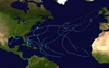
The 1995 Atlantic hurricane season was a very active Atlantic hurricane season, and is considered to be the start of an ongoing era of high-activity tropical cyclone formation. The season produced twenty-one tropical cyclones, nineteen named storms, as well as eleven hurricanes and five major hurricanes. The season officially began on June 1 and ended on November 30, dates which conventionally delimit the period of each year when most tropical cyclones develop in the Atlantic basin. The first tropical cyclone, Hurricane Allison, developed on June 2, while the season's final storm, Hurricane Tanya, transitioned into an extratropical cyclone on November 1. The very active Atlantic hurricane activity in 1995 was caused by La Niña conditions, which also influenced an inactive Pacific hurricane season. It was tied with 1887 Atlantic hurricane season with 19 named storms, which was later equalled by the 2010, 2011, and 2012 seasons.

<span class="mw-page-title-main">1963 Atlantic hurricane season</span> Hurricane season in the Atlantic Ocean

The 1963 Atlantic hurricane season It was a slightly below average season in terms of tropical cyclone formation, with a total of ten nameable storms. Even so, it was also a notoriously deadly and destructive season. The season officially began on June 15, 1963, and lasted until November 15, 1963. These dates conventionally delimit the period of each year when most tropical cyclones form in the Atlantic basin. The first system, an unnamed tropical storm, developed over the Bahamas on June 1.

<span class="mw-page-title-main">Hurricane Jeanne</span> Category 3 Atlantic hurricane in 2004

Hurricane Jeanne was a Category 3 hurricane that struck the Caribbean and the Eastern United States in September 2004. It was the deadliest hurricane in the Atlantic basin since Mitch in 1998. It was the tenth named storm, the seventh hurricane, and the fifth major hurricane of the season, as well as the third hurricane and fourth named storm of the season to make landfall in Florida. After wreaking havoc on Hispaniola, Jeanne struggled to reorganize, eventually strengthening and performing a complete loop over the open Atlantic. It headed westwards, strengthening into a Category 3 hurricane and passing over the islands of Great Abaco and Grand Bahama in the Bahamas on September 25. Jeanne made landfall later in the day in Florida just two miles from where Hurricane Frances had struck a mere three weeks earlier.

<span class="mw-page-title-main">Hurricane Marilyn</span> Category 3 Atlantic hurricane in 1995

Hurricane Marilyn was the most powerful hurricane to strike the Virgin Islands since Hurricane Hugo of 1989, and the third such tropical cyclone in roughly a two-week time span to strike or impact the Leeward Islands, the others being Hurricane Iris and the much more powerful and destructive Hurricane Luis. The thirteenth named storm, seventh hurricane and third major hurricane of the extremely active 1995 Atlantic hurricane season, Marilyn formed on September 12 as a tropical depression from a tropical wave that moved off the coast of Africa on September 7. After formation, the storm quickly became a tropical storm, and steadily intensified into a hurricane by the time it struck the Lesser Antilles on September 14 at Category 1 strength. Entering the northeastern Caribbean Sea, rapid intensification ensued and it peaked on September 16 north of Puerto Rico as a Category 3 hurricane shortly after it had impacted the U.S. Virgin Islands. A Hurricane Hunter reconnaissance flight reported hail, which is unusual for tropical cyclones. After heading north past Bermuda, Marilyn weakened and became extratropical on September 22. The remnant circulation wandered the Atlantic Ocean from September 23 – October 1, just south of Nova Scotia.

<span class="mw-page-title-main">Hurricane Debby (2000)</span> Category 1 Atlantic hurricane in 2000

Hurricane Debby caused minor damage in the Greater and Lesser Antilles in August 2000. The seventh tropical cyclone, fourth named storm, and second hurricane of the annual season, Debby developed from a tropical wave east of the Lesser Antilles on August 19. Favorable conditions allowed the depression to become Tropical Storm Debby early on August 20, and further strengthening into a hurricane occurred 24 hours later. Sustained winds peaked at 85 mph (137 km/h) on August 21. Debby made three landfalls on August 22, in Barbuda, Saint Barthélemy, and Virgin Gorda, before re-entering the Atlantic north of Puerto Rico. As Debby moved parallel to the north coast of Hispaniola late on August 23, it weakened back to a tropical storm. The storm tracked westward and weakened further, instead of approaching Florida and strengthening into a major hurricane. While south of eastern Cuba on August 24, Debby was downgraded to a tropical depression, six hours before completely dissipating.

<span class="mw-page-title-main">Hurricane Edith (1963)</span> Category 2 Atlantic hurricane in 1963

Hurricane Edith brought flooding and wind damage to portions of the Greater and Lesser Antilles. The sixth tropical storm and fifth hurricane of the 1963 season, Edith developed east of the Windward Islands on September 23 from an Intertropical Convergence Zone (ITCZ) disturbance. Initially a tropical depression, it strengthened into Tropical Storm Edith the next day. Shortly thereafter, Edith reached hurricane status. Edith fluctuated between Category 1 and 2 status as it moved west-northwest. Upon reaching Category 2 intensity on September 25, the storm peaked with winds of 100 mph (155 km/h). After striking Saint Lucia on September 25, the storm traversed the eastern Caribbean Sea. Curving north-northwest on September 26, Edith made landfall near La Romana, Dominican Republic, early on the following day as a minimal hurricane. Interaction with land and an upper-level trough caused Edith to weaken to a tropical storm on September 28 and to a tropical depression by the next day. The storm dissipated just east of the Bahamas on September 29.

<span class="mw-page-title-main">2017 Atlantic hurricane season</span> Hurricane season in the Atlantic Ocean

The 2017 Atlantic hurricane season was a devastating and extremely active Atlantic hurricane season, and the costliest on record, with a damage total of at least $294.92 billion (USD). The season featured 17 named storms, 10 hurricanes, and 6 major hurricanes. Most of the season's damage was due to hurricanes Harvey, Irma, and Maria. Another notable hurricane, Nate, was the worst natural disaster in Costa Rican history. These four storm names were retired following the season due to the number of deaths and amount of damage they caused.

<span class="mw-page-title-main">2019 Atlantic hurricane season</span> Hurricane season in the Atlantic Ocean

The 2019 Atlantic hurricane season was the fourth consecutive above-average and damaging season dating back to 2016. The season featured eighteen named storms, however, many storms were weak and short-lived, especially towards the end of the season. Six of those named storms achieved hurricane status, while three intensified into major hurricanes. Two storms became Category 5 hurricanes, marking the fourth consecutive season with at least one Category 5 hurricane, the third consecutive season to feature at least one storm making landfall at Category 5 intensity, and the seventh on record to have multiple tropical cyclones reaching Category 5 strength. The season officially began on June 1 and ended on November 30. These dates historically describe the period each year when most tropical cyclones form in the Atlantic basin and are adopted by convention. However, tropical cyclogenesis is possible at any time of the year, as demonstrated by the formation of Subtropical Storm Andrea on May 20, making this the fifth consecutive year in which a tropical or subtropical cyclone developed outside of the official season.

<span class="mw-page-title-main">2020 Atlantic hurricane season</span> Hurricane season in the Atlantic Ocean

The 2020 Atlantic hurricane season was the most active Atlantic hurricane season on record, in terms of number of systems. It featured a total of 31 tropical or subtropical cyclones, with all but one cyclone becoming a named storm. Of the 30 named storms, 14 developed into hurricanes, and a record-tying seven further intensified into major hurricanes. It was the second and final season to use the Greek letter storm naming system, the first being 2005, the previous record. Of the 30 named storms, 11 of them made landfall in the contiguous United States, breaking the record of nine set in 1916. During the season, 27 tropical storms established a new record for earliest formation date by storm number. This season also featured a record ten tropical cyclones that underwent rapid intensification, tying it with 1995, as well as tying the record for most Category 4 hurricanes in a singular season in the Atlantic Basin. This unprecedented activity was fueled by a La Niña that developed in the summer months of 2020, continuing a stretch of above-average seasonal activity that began in 2016. Despite the record-high activity, this was the first season since 2015 in which no Category 5 hurricanes formed.

<span class="mw-page-title-main">Hurricane Bertha (2014)</span> Category 1 Atlantic hurricane in 2014

Hurricane Bertha was an unusual tropical cyclone in early August 2014 that attained hurricane status, despite having a disheveled appearance and an abnormally high atmospheric pressure. The third tropical cyclone and second hurricane of the season, Bertha developed from a tropical wave south of Cape Verde was monitored first for possible tropical cyclogenesis on July 26. Over the following days, it slowly developed and acquired gale-force winds and enough convection to be designated as Tropical Storm Bertha early on August 1. A mostly disorganized cyclone, Bertha quickly moved across the Lesser Antilles, clipping the northern end of Martinique, later that day. During its trek across the eastern Caribbean Sea, its circulation became severely disrupted and it may have degenerated into a tropical wave. On August 3, it traversed the Mona Passage and moved over the Southeastern Bahamas where conditions favored development. Despite an overall ragged appearance on satellite imagery, data from Hurricane Hunters indicated it intensified to a hurricane on August 4; it acquired peak winds of 80 mph (130 km/h) that day. Turning north, and later northeast, Bertha soon weakened as it began to merge with an approaching trough to the west. This merger ultimately took place on August 6, at which time Bertha was declared extratropical well to the south of Nova Scotia. The remnant system raced eastward across the Atlantic and later struck the United Kingdom on August 10. Once over the North Sea, the storm stalled for a few days before resuming its eastward track. It was last noted around the Baltic Sea on August 16.

<span class="mw-page-title-main">Tropical Storm Bret (2017)</span> Atlantic tropical storm in 2017

Tropical Storm Bret was the earliest named storm in the calendar year to develop in the Main Development Region of the Atlantic basin on record. The second tropical cyclone of the 2017 Atlantic hurricane season, Bret formed from a tropical wave that had exited off the coast of West Africa on June 12. The disturbance moved swiftly across the Atlantic for several days, steadily organizing despite its low latitude. On June 18, the organization increased enough for the National Hurricane Center (NHC) to begin issuing warnings disturbance while it was located southeast of the Windward Islands. The system continued to organize, and by the next day, it had developed into a tropical storm, the second of the 2017 Atlantic hurricane season. Bret continued moving swiftly to the west and struck Trinidad and Tobago early on June 20, before entering the Caribbean Sea, dissipating shortly afterwards.

<span class="mw-page-title-main">2022 Atlantic hurricane season</span> Hurricane season in the Atlantic Ocean

The 2022 Atlantic hurricane season was a very destructive Atlantic hurricane season, which had an average number of named storms. Despite this, it became the third-costliest Atlantic hurricane season on record, behind only 2017 and 2005, mostly due to Hurricane Ian. The season officially began on June 1, and ended on November 30. These dates, adopted by convention, historically describe the period in each year when most subtropical or tropical cyclogenesis occurs in the Atlantic Ocean. This year's first Atlantic named storm, Tropical Storm Alex, developed five days after the start of the season, making this the first season since 2014 not to have a pre-season named storm.

<span class="mw-page-title-main">Hurricane Beryl</span> Category 1 Atlantic hurricane in 2018

Hurricane Beryl was a fast-moving and long-lived tropical cyclone that formed in the main development region. The second named storm and first hurricane of the 2018 Atlantic hurricane season, Beryl formed from a vigorous tropical wave that moved off the west coast of Africa on July 1. The wave quickly organized into a tropical depression over the central Atlantic Ocean on July 4. Rapid intensification took place and the depression quickly became a tropical storm at 00:00 UTC the next day. Just less than 15 hours later, on July 6, Beryl strengthened into the first hurricane of the season, reaching its peak intensity on July 6. Increasingly unfavorable conditions caused a rapid deterioration of the cyclone shortly after its peak, with Beryl falling to tropical storm status on the next day, as it began to accelerate towards the Caribbean. Late on July 8, it degenerated into a tropical wave shortly before reaching the Lesser Antilles. The remnants were monitored for several days, although they failed to organize significantly until July 14, when it regenerated into a subtropical storm, six days after it lost tropical characteristics. However, the newly reformed storm quickly lost convection, and it degenerated into a remnant low early on July 16, while situated over the Gulf Stream. Beryl subsequently dissipated on the next day.

<span class="mw-page-title-main">Timeline of the 2019 Atlantic hurricane season</span>

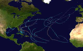
The 2019 Atlantic hurricane season was an event in the annual tropical cyclone season in the north Atlantic Ocean. It was the fourth consecutive above-normal Atlantic hurricane season. The season officially began on June 1, 2019 and ended on November 30, 2019. These dates, adopted by convention, historically describe the period in each year when most tropical systems form. However, storm formation is possible at any time of the year, as demonstrated in 2019 by the formation of the season's first named storm, Subtropical Storm Andrea, on May 20. The final storm of the season, Tropical Storm Sebastien, transitioned to an extratropical cyclone on November 25.

<span class="mw-page-title-main">Hurricane Dorian</span> Category 5 Atlantic hurricane in 2019

Hurricane Dorian was an extremely powerful and catastrophic Category 5 Atlantic hurricane, which became the most intense tropical cyclone on record to strike the Bahamas, and is tied with the 1935 Labor Day hurricane for the strongest landfall in the Atlantic basin in terms of maximum sustained winds. The 2019 cyclone is regarded as the worst natural disaster in the Bahamas' recorded history. With winds peaking at 185 mph (295 km/h), it was also one of the most powerful hurricanes recorded in the Atlantic Ocean in terms of 1-minute sustained winds, and the strongest since Wilma in 2005. Dorian was the fourth named storm, second hurricane, the first major hurricane, and the first Category 5 hurricane of the 2019 Atlantic hurricane season. Dorian struck the Abaco Islands on September 1 with maximum sustained winds of 185 mph (295 km/h), tying with the 1935 Labor Day hurricane for the highest wind speeds of an Atlantic hurricane ever recorded at landfall. Dorian went on to strike Grand Bahama at similar intensity, stalling just north of the territory with unrelenting winds for at least 24 hours. The resultant damage to these islands was catastrophic; most structures were flattened or swept to sea, and at least 70,000 people were left homeless. After it ravaged through the Bahamas, Dorian proceeded along the coasts of the Southeastern United States and Atlantic Canada, leaving behind considerable damage and economic losses in those regions.

<span class="mw-page-title-main">Hurricane Isaias</span> Category 1 Atlantic hurricane in 2020

Hurricane Isaias was a destructive Category 1 hurricane that caused extensive damage across the Caribbean and the East Coast of the United States while also spawning the strongest tropical cyclone-spawned tornado since Hurricane Rita in 2005. The ninth named storm and second hurricane of the extremely active and record-breaking 2020 Atlantic hurricane season, Isaias originated from a vigorous tropical wave off the coast of Africa that was first identified by the National Hurricane Center on July 23. The tropical wave gradually became more organized and obtained gale-force winds on July 28 before organizing into Tropical Storm Isaias on July 30. Isaias marked the earliest ninth named storm on record, surpassing 2005's Hurricane Irene by eight days. Isaias strengthened into a Category 1 hurricane on the next day, reaching an initial peak of 85 mph (137 km/h), with a minimum central pressure of 987 mbar. On August 1, the storm made landfall on North Andros, Bahamas and subsequently weakened to a tropical storm, before paralleling the east coast of Florida and Georgia. As Isaias approached the Carolina coastline, it reintensified back into a hurricane. Soon afterward, Isaias reached its peak intensity, with maximum 1-minute sustained winds of 90 mph (140 km/h) and a minimum central pressure of 986 millibars (29.1 inHg), before making landfall near Ocean Isle Beach, North Carolina, at 03:10 UTC on August 4, at the same intensity. The storm proceeded to accelerate up the East Coast of the United States as a strong tropical storm, before transitioning into an extratropical cyclone over Quebec on August 4. Isaias's extratropical remnants persisted for another day, before dissipating on August 5.

<span class="mw-page-title-main">Hurricane Teddy</span> Category 4 Atlantic hurricane in 2020

Hurricane Teddy was a large and powerful Cape Verde hurricane that was the fifth-largest Atlantic hurricane by diameter of gale-force winds recorded. Teddy produced large swells along the coast of the Eastern United States and Atlantic Canada in September 2020. The twentieth tropical depression, nineteenth named storm, eighth hurricane, and second major hurricane of the record-breaking 2020 Atlantic hurricane season, Teddy initially formed from a tropical depression that developed from a tropical wave on September 12. Initially, the depression's large size and moderate wind shear kept it from organizing, but it eventually intensified into Tropical Storm Teddy on September 14. After steadily intensifying for about a day, the storm rapidly became a Category 2 hurricane on September 16 before westerly wind shear caused a temporary pause in the intensification trend. It then rapidly intensified again on September 17 and became a Category 4 hurricane. Internal fluctuations and eyewall replacement cycles then caused the storm to fluctuate in intensity before it weakened some as it approached Bermuda. After passing east of the island as a Category 1 hurricane on September 21, Teddy restrengthened back to Category 2 strength due to baroclinic forcing. It weakened again to Category 1 strength the next day before becoming post-tropical as it approached Atlantic Canada early on September 23. It then weakened to a gale-force low and made landfall in Nova Scotia with sustained winds of 65 mph (105 km/h). The system weakened further as it moved northward across eastern Nova Scotia and then the Gulf of St. Lawrence, before being absorbed by a larger non-tropical low early on September 24, near eastern Labrador.

<span class="mw-page-title-main">Tropical Storm Fred (2021)</span> Atlantic tropical storm in 2021

Tropical Storm Fred was a strong tropical storm which affected much of the Greater Antilles and the Southeastern United States in August 2021. The sixth tropical storm of the 2021 Atlantic hurricane season, Fred originated from a tropical wave first noted by the National Hurricane Center on August 4. As the wave drifted westward, advisories were initiated on the wave as a potential tropical cyclone by August 9 as it was approaching the Leeward Islands. Entering the Eastern Caribbean Sea after a close pass to Dominica by the next day, the potential tropical cyclone continued northwestward. By August 11, the disturbance had formed into Tropical Storm Fred just south of Puerto Rico, shortly before hitting the Dominican Republic on the island of Hispaniola later that day. The storm proceeded to weaken to a tropical depression over the highly mountainous island, before emerging north of the Windward Passage on August 12. The disorganized tropical depression turned to the west and made a second landfall in Northern Cuba on August 13. After having its circulation continuously disrupted by land interaction and wind shear, the storm degenerated into a tropical wave as it was turning northward near the western tip of Cuba the following day. Continuing north, the remnants of Fred quickly re-organized over the Gulf of Mexico, regenerating into a tropical storm by August 15. Fred continued towards the Florida Panhandle and swiftly intensified to a strong 65 mph (105 km/h) tropical storm before making landfall late on August 16 and moving into the state of Georgia. Afterward, Fred continued moving north-northeastward, before degenerating into an extratropical low on August 18. Fred's remnants later turned eastward, and the storm's remnants dissipated on August 20, near the coast of Massachusetts.

<span class="mw-page-title-main">Hurricane Bonnie (2022)</span> Category 3 Atlantic and Pacific hurricane in 2022

Hurricane Bonnie was a strong tropical cyclone that survived the crossover from the Atlantic Ocean to the Pacific Ocean, the first to do so since Hurricane Otto in 2016. The second named storm of the 2022 Atlantic hurricane season, it originated from a strong tropical wave that moved off the west coast of Africa on June 23. Moving with little development despite favorable conditions, the National Hurricane Center (NHC) started advisories on it as Potential Tropical Cyclone Two late on June 27, due to its imminent threat to land. The disturbance finally organized into Tropical Storm Bonnie at 13:15 UTC on July 1, and made brief landfalls on the Costa Rica–Nicaragua border with winds of 50 miles per hour (80 km/h). It later became the fourth named storm, third hurricane, and first major hurricane of the 2022 Pacific hurricane season after crossing Nicaragua and Costa Rica from east to west on July 2 and intensifying to a Category 3 hurricane on July 5. Bonnie rapidly weakened, dissipating over the North Pacific.

<span class="mw-page-title-main">Hurricane Fiona</span> Category 4 Atlantic hurricane in 2022

Hurricane Fiona was a large, powerful, and destructive Category 4 Atlantic hurricane which was the costliest and most intense tropical or post-tropical cyclone to hit Canada on record. It was the sixth named storm, third hurricane and first major hurricane of the 2022 Atlantic hurricane season.

References

  1. 1 2 3 4 5 6 7 8 9 John Cangialosi, Nelsie Ramos (December 16, 2019). "Tropical Cyclone Report - Tropical Storm Karen" (PDF). Miami, Florida: National Hurricane Center. Retrieved December 25, 2020.
  2. Eric Blake (September 18, 2019). "Five-Day Graphical Tropical Weather Outlook". Miami, Florida: National Hurricane Center. Retrieved December 25, 2020.
  3. David Zelinsky (September 20, 2019). "Five-Day Graphical Tropical Weather Outlook". Miami, Florida: National Hurricane Center. Retrieved December 25, 2020.
  4. Stacy Stewart (September 22, 2019). "Tropical Storm Karen Advisory Number 1". Miami, Florida: National Hurricane Center. Retrieved December 25, 2020.
  5. "Tropical Storm Karen Intermediate Advisory Number 1A". Miami, Florida: National Hurricane Center. September 22, 2019. Retrieved December 25, 2020.
  6. John Cangialosi (September 24, 2019). "Tropical Depression Karen Discussion Number 8". National Hurricane Center. Retrieved December 25, 2020.
  7. Stacy R. Stewart (September 24, 2019). "Tropical Storm Karen Advisory Number 9". Miami, Florida: National Hurricane Center. Retrieved December 25, 2020.
  8. Jack Beven (September 24, 2019). "Tropical Storm Karen Intermediate Advisory 10A". Miami, Florida: National Hurricane Center. Retrieved December 25, 2020.
  9. Lixion Avila (September 25, 2019). "Tropical Storm Karen Intermediate Advisory Number 11A". Miami, Florida: National Hurricane Center. Retrieved December 30, 2020.
  10. John Cangialosi (September 26, 2019). "Tropical Storm Karen Advisory Number 17". National Hurricane Center. Retrieved December 26, 2020.
  11. Robbie Berg (September 26, 2019). "Tropical Storm Karen Discussion Number 19". Miami, Florida: National Hurricane Center. Retrieved December 26, 2020.
  12. Lixion Avila (September 27, 2020). "Tropical Storm Karen Advisory Number 20". Miami, Florida: National Hurricane Center. Retrieved December 26, 2020.
  13. David Zelinsky (September 27, 2019). "Tropical Storm Karen Discussion Number 21". Miami, Florida: National Hurricane Center. Retrieved December 26, 2020.
  14. Robbie Berg (September 27, 2019). "Remnants of Karen Advisory Number 23". Miami, Florida: National Hurricane Center. Retrieved December 26, 2020.
  15. 1 2 Stacy R. Stewart (September 22, 2019). "Tropical Storm Karen Forecast Advisory Number 1". Miami, Florida: National Hurricane Center. Retrieved December 25, 2020.
  16. Daniel Brown (September 22, 2019). "Tropical Storm Karen Intermediate Advisory Number 2A". Miami, Florida: National Hurricane Center. Retrieved December 25, 2020.
  17. Camille Moreno (September 22, 2019). "TT under warning for Tropical Storm Karen". Trinidad and Tobago Newsday. Retrieved December 25, 2020.
  18. "'Karen' postpones final Ascension fixtures with 'Army', Deportivo, Giants and UTT chasing glory". Wired 868. September 22, 2019. Retrieved December 27, 2020.
  19. "Status Update on National Emergency Health Services Re: – Passage Tropical Storm Karen" (PDF). Trinidad and Tobago Ministry of Health. September 22, 2019. Retrieved December 25, 2020.
  20. Ron Brackett (September 23, 2019). "Tropical Storm Karen Floods Streets, Traps People in Homes in Tobago". The Weather Channel. Retrieved December 25, 2020.
  21. Kinnesha George (October 2, 2019). "Karen leaves man homeless". Trinidad and Tobago Newsday. Retrieved December 28, 2020.
  22. Janelle De Souza (September 26, 2019). "Ministry urges farmers to make claims for TS Karen loss". Trinidad and Tobago Newsday. Retrieved December 28, 2020.
  23. Carol Matroo (September 23, 2019). "Karen spares East Trinidad". Trinidad and Tobago Newsday. Retrieved December 27, 2020.
  24. Julien Neaves (November 29, 2019). "Tobago, Bamboo worst hit by Tropical Storm Karen". Trinidad and Tobago Newsday. Retrieved December 28, 2020.
  25. Corey Connelly (September 25, 2019). "Karen leaves 'Bago in a mess". Trinidad and Tobago Newsday. Retrieved December 27, 2020.
  26. Kinnesha George (September 25, 2019). "Tobago fishermen reeling from Karen's fury". Trinidad and Tobago Newsday. Retrieved December 28, 2020.
  27. Stephon Nicolas (October 22, 2019). "Karen leaves $24m damage". Trinidad and Tobago Newsday. Retrieved December 25, 2020.
  28. "Trinidad and Tobago – Tropical Storm Karen Causes Severe Flooding". FloodList. September 23, 2019. Retrieved December 29, 2020.
  29. Daniel Brown (September 22, 2019). "Tropical Storm Karen Advisory Number 2". Miami, Florida: National Hurricane Center. Retrieved December 25, 2020.
  30. Stacy R. Stewart (September 23, 2019). "Tropical Storm Karen Forecast Advisory Number 5". Miami, Florida: National Hurricane Center. Retrieved December 25, 2020.
  31. 1 2 Stacy R. Stewart (September 25, 2019). "Tropical Storm Karen Forecast Advisory Number 13". Miami, Florida: National Hurricane Center. Retrieved December 25, 2020.
  32. 1 2 Barbara Campbell, Paolo Zialcita (September 24, 2019). "Tropical Storm Karen's Squalls Hit Puerto Rico, Virgin Islands". NPR. Retrieved December 25, 2020.
  33. Doyle Rice, John Bacon (September 23, 2019). "Tropical Storm Karen heads for Puerto Rico, could impact U.S. mainland next week". USA Today. Retrieved December 25, 2020.
  34. "Puerto Rico to close schools as Tropical Storm Karen threatens flooding". CNBC. Associated Press. September 23, 2019. Retrieved December 25, 2020.
  35. Carlson, Suzanne (September 26, 2019). "Waves crashing over Veterans Drive were not unexpected". Virgin Islands Daily News . Retrieved December 28, 2020.
  36. "Anguilla landfill closed due to storm damage". Virgin Islands Daily News. September 26, 2019. Retrieved December 28, 2020.
  37. Suzanne Carlson (September 25, 2019). "Tropical Storm Karen puts V.I. on hold". The Virgin Islands Daily News. Retrieved December 25, 2020.
  38. Faith Karimi, Steve Almasy (September 25, 2020). "Tropical Storm Karen speeds up after soaking Puerto Rico and the Virgin Islands". CNN. Retrieved December 26, 2020.
  39. Alex Sosnowski (September 24, 2019). "Karen unleashes heavy rain on Puerto Rico as it moves into the open Atlantic". AccuWeather. Retrieved December 28, 2020.
  40. "Tropical Storm Karen - September 24-25, 2019". National Weather Service - San Juan, PR. Retrieved December 26, 2020.
  41. EFE (September 24, 2020). "La tormenta tropical Karen se mueve sobre el este de Puerto Rico" (in Spanish). Listin Diario. Retrieved December 27, 2020.
  42. 1 2 ECHO (September 26, 2019). "Puerto Rico - Tropical Cyclone KAREN update (GDACS, NOAA, SNM, media) (ECHO Daily Flash of 26 September 2019)". ReliefWeb. Retrieved December 28, 2020.
  43. Ron Brackett; Jan Wesner Childs (September 25, 2019). "Tropical Storm Karen Causes Landslides, Power Outages in Puerto Rico, U.S. Virgin Islands". The Weather Channel. Retrieved February 29, 2020.
  44. "Storm Events Database Event: Debris Flow in Aibonito, Puerto Rico". National Centers for Environmental Information. Retrieved December 29, 2020.
  45. "Storm Events Database Event:Flash Flooding in Toa Baja, Puerto Rico (9/24/19)". National Centers for Environmental Information. Retrieved December 29, 2020.
  46. "Storm Event Database Event: Flash Flood in Toa Baja, Puerto Rico". National Centers for Environmental Information. Retrieved December 29, 2020.
  47. "Storm Events Database Event: Flash Flood in Dorado, Puerto Rico". National Centers for Environmental Information. Retrieved December 29, 2020.
  48. Associated Press, CBS News (September 25, 2019). "Worst appears over for Puerto Rico as Tropical Storm Karen heads north". CBS News. Retrieved December 29, 2020.
  49. "Tropical Storm Karen exits Caribbean after causing flooding, power outages". NBC News. Associated Press. September 25, 2019. Retrieved December 29, 2020.
  50. Suzanne Carlson (September 26, 2020). "Unexpectedly modest Karen still sets rainfall record on St. Thomas". Virgin Islands Daily News. Retrieved December 27, 2020.
  51. "Refinery's Foam Plastic Litters South Shore Months After September Storm". St. Croix Source. November 18, 2019. Retrieved December 28, 2020.
  52. "La Cruz Roja evalúa ofrecer asistencia por posibles daños causados por Karen" (in Spanish). El Nuevo Dia. September 25, 2019. Retrieved December 27, 2020.
  53. "WAPA Completes Post TS Karen Restoration Work Territory-wide". St. John Tradewinds. September 28, 2019. Retrieved December 28, 2020.
  54. Stacy R. Stewart (September 22, 2019). "Tropical Storm Karen Tropical Cyclone Update". Miami, Florida: National Hurricane Center. Retrieved December 25, 2020.
  55. Jack Beven (September 23, 2019). "Tropical Storm Karen Forecast Advisory Number 4". National Hurricane Center. Retrieved December 25, 2020.
  56. "Update: Tropical Storm Karen". NOW Grenada. September 22, 2019. Retrieved December 26, 2020.
  57. "Tropical Storm Warning For SVG Discontinued, Flood Watch Still In Effect". 784 News. September 22, 2019. Retrieved December 27, 2020.[ permanent dead link ]
  58. "Tropical Storm Warning in Effect for SVG, National Shut Down Declared". Searchlight. September 22, 2019. Retrieved December 27, 2020.
  59. 1 2 "Tropical Storm Karen leaves mark on svg". Searchlight. September 27, 2019. Retrieved December 27, 2020.
  60. "Union Island begins to feel the effects of Storm Karen". 784 News. September 22, 2020. Retrieved December 27, 2020.
  61. "Tormenta Tropical Karen provocó inundaciones en Caracas y La Guaira". Descifrado (in Spanish). September 22, 2019. Retrieved December 27, 2020.
  62. Daniel Brown (September 23, 2019). "TROPICAL STORM KAREN FORECAST/ADVISORY NUMBER 6". Miami, Florida: National Hurricane Center. Retrieved December 27, 2020.
  63. Joey Waldinger (September 26, 2019). "With wind and showers, Karen passes VI". The BVI Beacon. Retrieved December 27, 2020.

PD-icon.svg This article incorporates public domain material from websites or documents of the National Weather Service .

Tropical Storm Karen
Karen 2019-09-24 1800Z.jpg
Tropical Storm Karen moving over the Spanish Virgin Islands on September 24