Tropical Storm Talas (2011)

Last updated
Map key
  Tropical depression (≤38 mph, ≤62 km/h)
  Tropical storm (39–73 mph, 63–118 km/h)
  Category 1 (74–95 mph, 119–153 km/h)
  Category 2 (96–110 mph, 154–177 km/h)
  Category 3 (111–129 mph, 178–208 km/h)
  Category 4 (130–156 mph, 209–251 km/h)
  Category 5 (≥157 mph, ≥252 km/h)
  Unknown
Storm type
Disc Plain black.svg Tropical cyclone
Solid black.svg Subtropical cyclone
ArrowUp.svg Extratropical cyclone, remnant low, tropical disturbance, or monsoon depression

Late on August 22, an area of low pressure developed to the west of Guam. [3] At midnight that day, the system became sufficiently well organized that the Japan Meteorological Agency (JMA) started tracking it as a tropical depression. [4] On August 23, the system moved into an environment of low wind shear and warm sea surface temperatures prompting the JTWC to issue a Tropical Cyclone Formation Alert (TCFA) on it. [5] By August 25, the system grew strong enough that the JMA upgraded it to a tropical storm, naming it Talas. [6] Soon the system developed long and expansive convective banding along the eastern and south-western periphery of the broad low level circulation center, similar to a monsoonal depression. The JTWC initiated advisories on the system, designating it with 15W. The JTWC originally anticipated a fujiwhara effect of Typhoon Nanmadol, a stronger tropical cyclone to the west of Talas. [7]

However, the two cyclones moved far away from each other with at least 1,000 nautical miles (1,900 km; 1,200 mi) of distance between them. This prompted the JTWC to change its forecast on the system, from turning west and interacting with Nanmadol, to continuously move north and intensify into a typhoon. [8] This prompted the JMA to upgrade Talas to a severe tropical storm with winds of 50 knots (95 km/h; 60 mph). [9] Multiple competitive steering ridges caused Talas to move in a poleward direction with stronger winds in the periphery and weaker winds near the center. A tropical upper tropospheric trough (TUTT) caused subsidance in the atmosphere which caused a disturbance in the outflow towards the northwest of the system. However, another TUTT cell to the northeast opened an outflow channel which kept Talas from being destroyed by shear. [10] Talas was very loosely organized with a relatively open circulation center and very low consolidation around the core. Convection was also displaced towards the periphery and stronger wind shear kept Talas from strengthening. [11]

Talas, being located in a very weak steering environment hardly moved in 24 hours and was effectively trapped between strong subtropical ridges and an anticyclone. Talas failed to strengthen for a very long time and remained loosely organized with all the convection located in the periphery. [12] Early on August 28, Talas started to strengthen after a whole day in dry winds. The low-level circulation center started to get consolidated with deep convective bands wrapping into it. Talas was expected to make landfall over central Japan with strong winds. [13] Talas then moved into an environment favorable for slow development, with moist winds and significantly warm sea surface temperatures. The center became well organized with convective bands tightly wrapped into it. [14] Wind shear decreased and the center was wrapped with more tightly curved banding. The JTWC reported that there was more confidence in the strength and position of the system. They JTWC reported that they were expecting a peak intensity of 90 knots (165 km/h; 105 mph). [15]

Severe Tropical Storm Talas approaching Japan on September 2 Talas Terra MODIS picture 2011-09-02 (High Definition).jpg
Severe Tropical Storm Talas approaching Japan on September 2

Soon, the subtropical ridge to the west of the storm weakened and the subtropical ridge to the east of the system pushed Talas to the west. As a result, Talas accelerated towards the west maintaining strength and outflow. [16] An upper-level cyclone over the system suppressed the convection and kept it from reaching the center. Therefore, Talas remained weak and did not strengthen further. Convection never managed to consolidate the center and convective banding remained well away from the fully exposed low-level circulation center. [17] Convective banding completely encircled the LLCC but never managed to consolidate over the LLCC because of the strong upper-lever cyclone over the storm. Talas was being steered by a mid-level anticyclone, a part of the developing omega block. [18] On September 1, Talas developed a large annulus of nearly 110 nautical miles (205 km; 125 mi) in diameter with multiple weak circulations cyclonically rotating around a centroid within the center. Fragmented deep convective banding broadly wrapped the low-level circulation center with an upper-level cyclone over the center and anticyclonic flow around the periphery of the storm. [19]

Soon, Talas turned towards the Kansai region of Japan maintaining intensity with cloud tops warming around the expansive, nearly cloud-free 140 nautical miles (260 km; 160 mi) wide low level circulation center (LLCC). Gale-force winds were extending to over 200 nautical miles (370 km; 230 mi) towards the north. [20] The convective banding continued to expand more and more with the outer rainbands already brushing parts of Japan. Coastal areas in the nation have already reported gale-force winds several hours before landfall, while the Omega block continued to drive Talas towards the nation. [21] Land interaction weakened Talas, prompting the JMA to downgrade Talas from a typhoon to a severe tropical storm with winds of under 60 knots (110 km/h; 70 mph). [22]

On September 2, Talas accelerated towards Japan and started making landfall over Kōchi Prefecture, Japan. As a result, convective cloud tops started to warm up and banding became more fragmented. Talas maintained its large annulus with better poleward outflow enhanced by the strong mid latitude westerlies. [23] After making landfall over Aki, Japan early on September 3, Talas moved into an area of moderate wind shear (15–20 knots) along the western edge of a deep-layered subtropical ridge with a mid-latitude trough approaching from the northwest. [24] [25] As a result, the LLCC started weakening and slowed down over land. Also, the mid-latitude trough located to the northwest of the system started to weaken, which made the JTWC anticipate Talas to turn northwestward and accelerate as it enters the Sea of Japan. [26] However, Talas slowly drifted north and entered an area of strong wind shear (30–50 knots). On becoming exposed to wind shear and strong upper-level westerlies, Talas became grossly elongated to the northeast and convective banding became more shallow and fragmented. [27] On entering the cold waters of the Sea of Japan, Talas accelerated north at over 13 knots (24 km/h; 15 mph). The central convection became significantly eroded and was displaced to the north-east as Talas was exposed to a very strong wind shear of over 50 knots (95 km/h; 60 mph) that made the LLCC very distorted and difficult to pin-point. Talas was embedded in a baroclinic zone and the JTWC anticipated an extratropical transition, which prompted them to issue their final warning on the system. [28] On September 5, the JMA issued their final warning on the system, reporting that Talas had become extratropical over the Sea of Japan. [29] [30]

Preparations

As the storm strengthened into a severe tropical storm (typhoon operationally), the residents of Tokyo, Japan were informed to stay updated and stock up for Talas. Heavy rains and strong winds which could trigger flash flooding and landslides were expected. [31] Also, a strong rainstorm of 50 millimetres (2.0 in)70 millimetres (2.8 in) per hour was expected. [32] Talas was expected to cause rainfall and strong winds for an unusually long period of time because of its slow movement. [33] Worries grew as the typhoon was heading towards the area which was previously devastated by the 2011 Tōhoku earthquake and tsunami. Parts of Tohoku where the tsunami occurred are still in ruins. [34]

Impact

The heavy rains from Talas triggered numerous landslides, such as this one in Kiho, across the mountainous terrain of Japan. Kihotown Sehara Miepref No,3.jpg
The heavy rains from Talas triggered numerous landslides, such as this one in Kihō, across the mountainous terrain of Japan.

Talas slowed down on approaching Japan, bringing heavy rainfall to the southern coast. In Shunan, Yamaguchi, extremely heavy rainfall of 66.5 millimeters per hour was observed, with rainfall of 69.0 mm in Yamanakako, Yamanashi, and 49.5 mm in Ichinoseki, Iwate which exceeded overall records for the entire month of September. [35] As the typhoon approached, The Fujisankei Classic, an annual golf event on the Japan Golf Tour was disrupted by the heavy rain. [36] Heavy rains triggered flash flooding, which killed one person, and injured 17 leaving three more missing soon after the landfall. [37] Some 3,200 people were evacuated in 16 prefectures after the typhoon slammed the island nation with extremely heavy rains. [38] The Central Japan Railway Company had to suspend its bullet train services on the Tokaido Shinkansen Line between Gifu-Hashima and Maibara railway stations because of the storm. [39] More than 300 houses were flooded while several landslides were reported since the storm's landfall in southern Japan. Also, since the storm was moving unusually slow, it worsened the condition. [40] NHK confirmed that the number of dead was 27, the number of injured was 106 and the number of missing was 49. [41]

Some 700 houses were completely inundated by the floodwaters spawned by Talas in eastern and western Japan and about 9,500 households in nine prefectures across the nation were without power after power outages. More than 400 flights were cancelled leaving some 34,000 stranded. [42] Most of the devastation occurred in Osaka, where a flooded river washed away two complete houses and a landslide destroyed four houses. Extremely heavy rainfall of as high as 170 centimetres (67 in) was dumped over Osaka since Talas approached Japan. [43] The heavy rainfall triggered obvious flooding in the rivers, but so extreme that an entire bridge was washed away. [44]

I have to think about how to help the people of the town deal with this disaster. Only after that can I think about my family. I hope that I can find my wife soon to send off my family with my daughter.

Talas poured record rainfall across the nation stranding thousands, turning towns into lakes and washed away cars, setting off mudslides. The storm also damaged the Nijō Castle, a flatland castle located in Kyoto, Japan. [46] On September 5, Japanese rescue workers started digging through the debris to look for the missing since the number of missing is unusually high. [47] Death toll continued to rise after the intense mudslides and flooding triggered by Talas. CNN reported that local authorities raised the death toll to 29 and the number of missing to 56. The Japanese government started an emergency search-and-rescue operation to begin reconstruction of damaged communities and to find those missing. [48] Ever since the typhoon approached land, Talas continuously dumped heavy rain over the Wakayama, Nara and Mie prefectures turning a large portion of the area to swamps. More than 750 Self-Defense Forces have been deployed in order to help local police and firefighters with the rescue and search operations. Talas broke a record of 1,322 millimetres (52.0 in) rainfall that fell on the southern town of Takachiho in Miyazaki Prefecture in September 2005. Talas's rainfall also exceeded the year round average of rainfall that falls over the city of Tokyo. [49] Most of the deaths were reported in Wakayama Prefecture where at least 17 people are reported to have been killed. The typhoon caused most of the substantial damage in the Kii Peninsula, that is located just a few hundreds of kilometers south of the tsunami-ravaged coast. As of 2023, landslides and infrastructure damage are still highly evident throughout the Kii peninsula, including damage to the Kumano Kodo World Heritage sites. [2] The death toll continued to rise rapidly and on the same day, Kyodo News updated the number of deaths to 32 and the number of missing to 57. Japan's newly elected Prime Minister Yoshihiko Noda said "We will do everything we can to rescue people and search for the missing". [50] Both remnants of Talas and the outflow of Tropical Storm Noru together brought heavy rainfall of over 400 mm in Hokkaido. [51]

Aftermath of river flooding in Totsukawa, Nara Totsukawa I power station aqueduct03.JPG
Aftermath of river flooding in Totsukawa, Nara

Electric and telephone lines in Mie, Nara and Wakayama prefectures were damaged, leaving some 194,000 households in the Kansai Electric Power Company's area with power outages. [52] On September 6, aid-laden helicopters landed in the hardest-hit areas while police, firefighters and soldiers started clearing roads and debris so that they could distribute food, medicine and other assistance. [53] However, thousands of people remained isolated for a long time because of the bad conditions of the roads, that prevented rescue workers from quickly reaching the victims. Relief materials such as canned food, rice balls, and drinking water were being supplied to the victims since the operation was started. [54] Talas death toll continued to rise rapidly since the landfall. On September 7, the death toll was said to have increased to 40 with 50 people still missing. [55] Later the same day, death toll continued to rise and reached 54 after reports from the search and rescue operations listed more people as dead. [56] Soon, Air Worldwide reported that the total losses caused by Talas in Japan could have exceeded US$600 million. [57] On September 8, the death toll rose to 59, while 50 others were still missing. Hundreds more remained stranded after several roads were damaged by the typhoon. [58]

See also

Related Research Articles

<span class="mw-page-title-main">2001 Pacific typhoon season</span>

The 2001 Pacific typhoon season was the fourth and final consecutive year with below-average activity, mainly due to the presence of a strong La Niña that had persisted from 1998 to 2001. However, it was more active than the previous seasons, producing twenty-five named storms, sixteen typhoons and three super typhoons, with a near normal Accumulated Cyclone Energy (ACE) of 307.3 units. It ran year-round in 2001, with most tropical cyclones in the northwestern Pacific Ocean tending between May and November.

<span class="mw-page-title-main">Typhoon Jangmi (2008)</span> Pacific typhoon in 2008

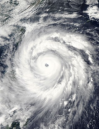
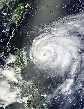
Typhoon Jangmi, known in the Philippines as Super Typhoon Ofel, was the most intense tropical cyclone in the Northwest Pacific Ocean during the 2000s, tied with Nida in 2009, and the most intense tropical cyclone worldwide in 2008. Jangmi, which means rose in Korean, formed in a low pressure area south of Guam on September 22. After undergoing serious consolidating with convective banding, the low pressure area was upgraded to a Joint Typhoon Warning Center late the same data. Undergoing the same process, the storm developed into a tropical storm on September 24. Undergoing rapid deepening on September 26–27, the storm, now a Super Typhoon entered the Philippine Area of Responsibility, and was named Ofel. The next day, Jangmi made impact in Taiwan, thousands were evacuated, rainfall, up to 994mm were recorded, and thousands of acres of farmland were destroyed. Jangmi was significantly weakened as it interacted with Taiwan, as being downgraded to tropical storm status after leaving Taiwan on September 29. After undergoing an extratropical transition, Jangmi became a remnant low on October 1. After slowly moving eastward, until finally dissipating near Iwo Jima on October 5.

<span class="mw-page-title-main">2009 Pacific typhoon season</span>

The 2009 Pacific typhoon season was a below average season that spawned only 22 named storms, 13 typhoons, and five super typhoons. It was also recognized as the deadliest season in the Philippines for decades. The first half of the season was very quiet whereas the second half of the season was extremely active. The season's first named storm, Kujira, developed on May 3 while the season's last named storm, Nida, dissipated on December 3.

<span class="mw-page-title-main">2011 Pacific typhoon season</span>

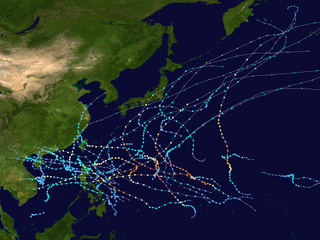
The 2011 Pacific typhoon season was a below average season that produced a total of 21 named storms, 8 typhoons, and four super typhoons. This season was much more active than the previous season, although both seasons were below the Pacific typhoon average of 26. The season ran throughout 2011, though most tropical cyclone tend to develop between May and October. The season's first named storm, Aere, developed on May 7 while the season's last named storm, Washi dissipated on December 19.

<span class="mw-page-title-main">2016 Pacific typhoon season</span>

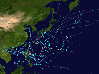
The 2016 Pacific typhoon season is considered to have been the fourth-latest start for a Pacific typhoon season since reliable records began. It was an average season, with a total of 26 named storms, 13 typhoons, and six super typhoons. The season ran throughout 2016, though typically most tropical cyclones develop between May and October. The season's first named storm, Nepartak, developed on July 3, while the season's last named storm, Nock-ten, dissipated on December 28.

<span class="mw-page-title-main">Typhoon Nanmadol (2011)</span> Pacific typhoon in 2011

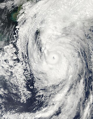
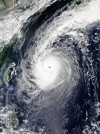
Typhoon Nanmadol, known in the Philippines as Super Typhoon Mina, was the strongest tropical cyclone in 2011 to hit the Philippines and also the second most intense tropical cyclone worldwide in 2011, and the first of the year to directly impact Taiwan and the rest of the Republic of China (ROC). Becoming the eleventh named storm, the seventh severe tropical storm and the fourth typhoon of the 2011 Pacific typhoon season, Nanmadol made a total of three landfalls killing 26, and causing widespread damage worth US$26,464,591. The area of low pressure that was about to become Nanmadol formed on August 19. It drifted north and became a tropical depression on August 21, a tropical storm on August 23 and a typhoon on the same night. Nanmadol reached peak strength with winds of 105 knots and 140 knots threatening the Philippines with heavy rain and flash flooding.

<span class="mw-page-title-main">Typhoon Roke (2011)</span> Pacific typhoon in 2011

Typhoon Roke, known in the Philippines as Tropical Storm Onyok, was a powerful and persistent tropical cyclone that affected Japan, including some areas that had been damaged by Talas just a few weeks prior. It was the fifteenth named storm, the tenth severe tropical storm, the sixth typhoon of the 2011 Pacific typhoon season and overall, the 27th tropical cyclone to be monitored by the Japan Meteorological Agency during the year.

<span class="mw-page-title-main">Typhoon Guchol (2012)</span> Pacific typhoon in 2012

Typhoon Guchol, known in the Philippines as Super Typhoon Butchoy, was a powerful tropical cyclone which became the first typhoon to make landfall in Japan on June since 2004. The storm formed as tropical disturbance south-southeast of Pohnpei on June 7, and was upgraded to a tropical depression on June 10. The system later intensified in favorable conditions, and reached typhoon intensity on June 15. It reached peak intensity late on June 17, before making landfall over Japan as a typhoon on June 19. The system became extratropical shortly after traversing Japan and was last noted by the Japan Meteorological Agency on June 22.

<span class="mw-page-title-main">Typhoon Kai-tak (2012)</span> Pacific typhoon in 2012

Typhoon Kai-tak, known in the Philippines as Severe Tropical Storm Helen, was a mild tropical cyclone that affected China, Vietnam and Laos. It was the seventh typhoon and the thirteenth named storm of the 2012 Pacific typhoon season. The storm killed 41 people and caused a sum of US$765 million in losses. Kai-tak can be tracked back to the broad area of disturbance embedded in a monsoonal trough that was first spotted, early on August 10. It was only at midnight, on August 16, when the JMA officially declared Kai-tak a typhoon. On the morning of August 17, the windspeed dropped to 60 knots and was no longer a typhoon. The typhoon caused heavy damage in China's two provinces killing four people and causing huge economic loss. Kai-Tak slammed the northern Philippines triggering flash floods and landslides and killing at least ten people, one week after deadly monsoon rains battered the country. In Vietnam, Kai-Tak has stormed across the country's north bringing high winds and floods to several areas including the capital Hanoi.

<span class="mw-page-title-main">Typhoon Tembin (2012)</span> Pacific typhoon in 2012

Typhoon Tembin, known in the Philippines as Typhoon Igme, was an intense tropical cyclone in the Western Pacific Ocean that had an unusual trajectory, approaching Taiwan twice. Tembin, which means balancing scale or Libra in Japanese, was the eighth typhoon and the fourteenth named storm of the 2012 Pacific typhoon season. After making landfall over the southern tip of Taiwan late on August 23, Tembin weakened but regained strength in the South China Sea, looping before making a second landfall on southern Taiwan as a tropical storm on August 27; however, the system did not restrengthen in the East China Sea, and made landfall over South Korea on August 30 before becoming extratropical.

<span class="mw-page-title-main">Cyclone Lehar</span> North Indian cyclone in 2013

Very Severe Cyclonic Storm Lehar was a tropical cyclone that primarily affected the Andaman and Nicobar Islands and the Indian state of Andhra Pradesh. Lehar was the second most intense tropical cyclone of the 2013 season, surpassed by Cyclone Phailin, as well as one of the two relatively strong cyclones that affected Southern India in November 2013, the other being Cyclone Helen.

<span class="mw-page-title-main">Typhoon Matmo (2014)</span> Pacific typhoon in 2014

Typhoon Matmo, known in the Philippines as Typhoon Henry, was the first tropical cyclone to impact Taiwan in 2014. It was the tenth named storm and the fourth typhoon of the 2014 Pacific typhoon season. The typhoon is believed to be one of the main reasons behind the crash of TransAsia Airways Flight 222, which occurred a day after it made landfall. There were fifty-four passengers on board and a crew of four, of whom 48 were killed. Taiwan News reported that "first suspicions hinted" the accident might be related to Matmo. The typhoon developed from a cluster of thundershowers consolidating around an area of low pressure in the doldrums. It initially followed a westward track, then made a sharp northwest turn before making landfall on Taiwan, and then China. After moving further inland, Matmo slowly curved back northeastwards and became extratropical before its remnants affected the Korean Peninsula.

<span class="mw-page-title-main">Tropical Storm Mekkhala (2015)</span> Pacific typhoon in 2015

Severe Tropical Storm Mekkhala, known in the Philippines as Severe Tropical Storm Amang, was an early-season tropical cyclone that made landfall over the Philippines in January 2015. Mekkhala killed three people in the Bicol Region and caused light crop damage. Notably, the storm disturbed Pope Francis’ visit to the country after the victims of Typhoon Haiyan on November 8, 2013. Although the storm also caused an airplane crash in Tacloban, nobody was hurt in the incident.

<span class="mw-page-title-main">Typhoon Mindulle (2016)</span> Pacific typhoon in 2016

Typhoon Mindulle was a strong tropical cyclone which affected Japan in August 2016. The ninth named storm and second typhoon of the 2016 Pacific typhoon season, Mindulle was first noted as a low-pressure area northwest of Guam on August 17. Two days later, it was upgraded into a tropical storm, being named Mindulle. Gradually intensifying, Mindulle peaked as a Category 1-equivalent hurricane on the Saffir-Simpson scale on August 22 before making landfall in Chiba Prefecture later that day. Mindulle rapidly weakened, dissipating the next day.

<span class="mw-page-title-main">Typhoon Chaba (2016)</span> Pacific typhoon in 2016

Typhoon Chaba, known in the Philippines as Super Typhoon Igme, was the fourth most intense tropical cyclone in 2016 and the strongest tropical cyclone to make landfall in South Korea since Sanba in 2012. Chaba also caused 7 deaths in the country. Typhoon Chaba was the eighteenth named storm and the eighth typhoon of the 2016 Pacific typhoon season. Chaba originated as a depression around the east-northeast of Guam. Being in a marginally favorable environment, JMA proceeds to name the system as Chaba. On September 28, JTWC gave its identifier as Tropical Depression 21W. Its LLCC starts to improve, prompting the JTWC to upgrade into a tropical storm. Chaba entered the Philippine Area of Responsibility, receiving the name Igme as it moved northwestwards. Chaba became more symmetrical which later ensued its rapid intensification.

<span class="mw-page-title-main">Tropical Storm Talas (2017)</span> Pacific severe tropical storm in 2017

Severe Tropical Storm Talas was a tropical cyclone that impacted Vietnam during mid July 2017. Talas was first tracked as a tropical disturbance over in the South China Sea on July 13, and was upgraded to a tropical depression during the next day. The depression intensified into the fourth named storm of the 2017 Pacific typhoon season during July 15. Before making landfall in Vietnam, Talas reached its peak intensity as a severe tropical storm during July 16. Talas weakened to an area of low pressure on July 17 inland.

<span class="mw-page-title-main">2021 Pacific typhoon season</span>

The 2021 Pacific typhoon season was the second consecutive to have below average tropical cyclone activity, with twenty-two named storms, and was the least active since 2011. Nine became typhoons, and five of those intensified into super typhoons. This low activity was caused by a strong La Niña that had persisted from the previous year. The season's first named storm, Dujuan, developed on February 16, while the last named storm, Rai, dissipated on December 21. The season's first typhoon, Surigae, reached typhoon status on April 16. It became the first super typhoon of the year on the next day, also becoming the strongest tropical cyclone in 2021. Surigae was also the most powerful tropical cyclone on record in the Northern Hemisphere for the month of April. Typhoons In-fa and Rai are responsible for more than half of the total damage this season, adding up to a combined total of $2.02 billion.

<span class="mw-page-title-main">2022 Pacific typhoon season</span>

The 2022 Pacific typhoon season was the third consecutive season to have below average tropical cyclone activity, with twenty-five named storms forming. Of the tropical storms, ten became typhoons, and three would intensify into super typhoons. The season saw near-average activity by named storm count, although many of the storms were weak and short-lived, particularly towards the end of the season. This low activity was caused by an unusually strong La Niña that had persisted from 2020. The season's first named storm, Malakas, developed on April 6, while the last named storm, Pakhar, dissipated on December 12. The season's first typhoon, Malakas, reached typhoon status on April 12. The season ran throughout 2022, though most tropical cyclones typically develop between May and October. Tropical storms Megi and Nalgae were responsible for more than half of the casualties, while typhoons Hinnamnor and Nanmadol both caused $1 billion in damages.

<span class="mw-page-title-main">2023 Pacific typhoon season</span>

The 2023 Pacific typhoon season was the fourth consecutive below-average season and became the third-most inactive typhoon season on record in terms of named storms, with just 17 named storms developing, only ahead of 2010 and 1998. Despite the season occurring during an El Niño event, which typically favors activity in the basin, activity was abnormally low. This was primarily due to a consistent period of negative PDO, which typically discourages tropical storm formation in this basin. The season was less active than the 2023 Atlantic hurricane season in terms of named storms, the fourth such season on record, after 2005, 2010 and 2020; and the first during an El Niño event. The season's number of storms also did not exceed that of the 2023 Pacific hurricane season. Only ten became typhoons, with four strengthening further into super typhoons. However, it was very destructive, primarily due to Typhoon Doksuri which devastated the northern Philippines, Taiwan, and China in July, becoming the costliest typhoon on record as well as the costliest typhoon to hit mainland China, and Typhoon Haikui in September, which devastated China, Taiwan, and Hong Kong. The season was less active in Southeast Asia, with no tropical storm making landfall in mainland Vietnam.

<span class="mw-page-title-main">Tropical Storm Haitang (2011)</span> Weak tropical storm which impacted Southeast Asia during 2011

Tropical Storm Haitang was a weak tropical cyclone which impacted China and Southeast Asia. The nineteenth named storm of the below-average 2011 Pacific typhoon season, Haitang developed from a disturbance in the South China Sea. After being recognized as a tropical depression on September 24, Haitang would peak as a minimal tropical storm before making landfall in Hue, Vietnam. Haitang would rapidly weaken once inland, dissipating in Laos in September 27.

References

  1. "Typhoon 201112 (Talas) Disaster Info". National Institute of Informatics. 2012. Retrieved September 17, 2012.
  2. 1 2 "Japan seeks survivors of Typhoon Talas". CBC 2011. 5 September 2011. Retrieved 5 September 2011.
  3. "JTWC - Tropical Cyclone Outlook 222300 - Tropical Depression 24". Joint Typhoon Warning Center. Archived from the original on August 23, 2011. Retrieved August 23, 2011.
  4. "JMA - Tropical Cyclone Advisory 230000 - Tropical Depression 22, 23, 24". JMA Tropical Cyclone Advisories. Japan Meteorological Agency. Archived from the original on October 19, 2011. Retrieved August 23, 2011.
  5. "JTWC - Tropical Cyclone Formation Alert - Tropical Depression 24". Joint Typhoon Warning Center. Archived from the original on October 21, 2011. Retrieved August 24, 2011.
  6. "JMA - Tropical Cyclone Advisory 250000 - Tropical Storm Talas". Japan Meteorological Agency. Archived from the original on May 23, 2024. Retrieved August 25, 2011.
  7. "JTWC - Tropical Cyclone Advisory 1 - Tropical Storm Talas". Joint Typhoon Warning Center. Archived from the original on May 23, 2024. Retrieved August 30, 2011.
  8. "JTWC - Tropical Cyclone Advisory 03 - Tropical Storm Talas". Joint Typhoon Warning Center. Archived from the original on May 23, 2024. Retrieved August 30, 2011.
  9. "JMA - Tropical Cyclone Advisory 260000 - Tropical Storm Talas". Japan Meteorological Agency. Archived from the original on May 23, 2024. Retrieved August 30, 2011.
  10. "JTWC - Tropical Cyclone Advisory 05 - Tropical Storm Talas". Joint Typhoon Warning Center. Archived from the original on May 23, 2024. Retrieved August 30, 2011.
  11. "JTWC - Tropical Cyclone Advisory 07 - Tropical Storm Talas". Joint Typhoon Warning Center. Archived from the original on May 23, 2024. Retrieved August 30, 2011.
  12. "JTWC - Tropical Cyclone Advisory 11 - Tropical Storm Talas". Joint Typhoon Warning Center. Archived from the original on May 23, 2024. Retrieved August 30, 2011.
  13. "JTWC - Tropical Cyclone Advisory 13 - Tropical Storm Talas". Joint Typhoon Warning Center. Archived from the original on May 23, 2024. Retrieved August 30, 2011.
  14. JTWC - Tropical Cyclone Advisory 15 - Tropical Storm Talas, Joint Typhoon Warning Center
  15. JTWC - Tropical Cyclone Advisory 17 - Tropical Storm Talas, Joint Typhoon Warning Center
  16. JTWC - Tropical Cyclone Advisory 25 - Tropical Storm Talas, Joint Typhoon Warning Center
  17. "JTWC - Tropical Cyclone Advisory 27 - Tropical Storm Talas". Joint Typhoon Warning Center.{{cite web}}: Missing or empty |url= (help)
  18. JTWC - Prognostic Reasoning for Tropical Cyclone Advisory 28 - Tropical Storm Talas, Joint Typhoon Warning Center
  19. "JTWC - Tropical Cyclone Advisory 29 - Tropical Storm Talas". Joint Typhoon Warning Center. September 2011. Retrieved 1 September 2011.
  20. "JTWC - Tropical Cyclone Advisory 31 - Tropical Storm Talas". Joint Typhoon Warning Center. 2 September 2011. Retrieved 2 September 2011.
  21. "JTWC - Prognostic Reasoning for Tropical Cyclone Advisory 32 - Tropical Storm Talas". Joint Typhoon Warning Center. 2 September 2011. Retrieved 2 September 2011.
  22. "JMA - Tropical Cyclone Advisory 020600 - Severe Tropical Storm Talas". Japan Meteorological Agency. 2 September 2011. Retrieved 2 September 2011.
  23. "JTWC - Prognostic Reasoning for Tropical Cyclone Advisory 34 - Tropical Storm Talas". Joint Typhoon Warning Center. 3 September 2011. Retrieved 3 September 2011.
  24. "台風12号 高知県に上陸へ". NHK . Retrieved 3 September 2011.[ permanent dead link ]
  25. "JTWC - Prognostic Reasoning for Tropical Cyclone Advisory 36 - Tropical Storm Talas". Joint Typhoon Warning Center. 3 September 2011. Retrieved 3 September 2011.
  26. "JTWC - Tropical Cyclone Advisory 37 - Tropical Storm Talas". Joint Typhoon Warning Center. 3 September 2011. Retrieved 3 September 2011.
  27. "JTWC - Tropical Cyclone Advisory 39 - Tropical Storm Talas". Joint Typhoon Warning Center. 4 September 2011. Retrieved 4 September 2011.
  28. "JTWC - Tropical Cyclone Advisory 40 - Tropical Storm Talas". Joint Typhoon Warning Center. 4 September 2011. Retrieved 4 September 2011.
  29. "台風12号が温帯低気圧に". NHK . Retrieved 5 September 2011.[ permanent dead link ]
  30. "JMA - Tropical Cyclone Advisory 050600 - Ex-Tropical Storm Talas". Japan Meteorological Agency. 5 September 2011. Retrieved 5 September 2011.
  31. "Tropical Storm Talas threatens Tokyo". Europ Assistance. Archived from the original on 2011-09-18. Retrieved 2011-08-30.
  32. "Strong typhoon approaches Japan". Monsters and Critics.com. Retrieved 2011-09-01.
  33. "Major typhoon headed to Japan archipelago". The Associated Press. Retrieved 2 September 2011.
  34. "Major typhoon headed to Japan, worries grow about heavy rainfalls in disaster zone". The Associated Press. Retrieved 2 September 2011.[ dead link ]
  35. "Strong typhoon likely to pound Japan on weekend, agency warns". Mainichi Japan. Archived from the original on 3 September 2011. Retrieved 2 September 2011.
  36. "Weather disrupts Fujisankei Classic". The Press Association. Retrieved 3 September 2011.
  37. "One Person Dead, Three Missing After Typhoon Talas Slams Into Western Japan". FOX News Network. 2 September 2011. Retrieved 3 September 2011.
  38. "Typhoon Talas reaches southern Japan, bringing heavy rain; reports of 1 dead, 5 missing". The Washington Post. Retrieved 3 September 2011.[ dead link ]
  39. "Typhoon Talas closes in on western Japan". MCIL Multimedia Sdn Bhd. Retrieved 3 September 2011.
  40. "Typhoon Talas hits Japan". 24.Com. Retrieved 3 September 2011.
  41. "全国で27人死亡 49人不明". NHK . Retrieved 5 September 2011.[ permanent dead link ]
  42. "Typhoon Talas hits western Japan". Independent Online. Retrieved 3 September 2011.
  43. "Typhoon leaves nine dead, 32 missing in western Japan". Herald and Weekly Times. Retrieved 4 September 2011.
  44. "Typhoon Talas rips through Japan". 24.Com. Retrieved 4 September 2011.
  45. "Japan Airlifts Supplies to Typhoon-Stranded Residents". VOANews. Retrieved 6 September 2011.
  46. "Typhoon Rains Kill at Least 25 and Maroon Thousands in Japan". The New York Times Company. 4 September 2011. Retrieved 5 September 2011.
  47. "Japanese Search for Missing After Deadly Typhoon". VOANews. Retrieved 5 September 2011.
  48. "Tropical Storm Talas leaves 29 dead, 56 missing in Japan". Cable News Network. 6 September 2011. Retrieved 5 September 2011.
  49. Koh, Yoree (5 September 2011). "Typhoon's Record Rainfall Wreaks Havoc". Dow Jones & Company. Retrieved 5 September 2011.
  50. "Typhoon toll reaches 32 dead, 57 missing". The Japan Times. Retrieved 5 September 2011.
  51. "北海道400ミリ超大雨 警戒を". NHK . Retrieved 6 September 2011.[ permanent dead link ]
  52. "Death toll from typhoon reaches 34 in Japan". Xinhua News Agency. Archived from the original on November 8, 2012. Retrieved 6 September 2011.
  53. "Air drops bring aid to typhoon-isolated Japanese". The Atlanta Journal-Constitution. Retrieved 6 September 2011.
  54. "Thousands remain trapped, rescue underway for Japan's worst typhoon disaster in decades". Xinhua News Agency. Archived from the original on September 26, 2011. Retrieved 7 September 2011.
  55. "Typhoon Talas death toll hits 40". Xinhua News Agency. Archived from the original on November 8, 2012. Retrieved 7 September 2011.
  56. "Typhoon killed 54 people 53 people missing" (in Japanese). NHK . Retrieved 7 September 2011.[ permanent dead link ]
  57. "Talas leaves up to $600 million in insured losses in Japan: AIR Worldwide". Crain Communications. Retrieved 8 September 2011.
  58. 台風12号による被害状況及び消防機関の活動状況等について(第14報) (PDF) (in Japanese). Fire and Disaster Management Agency. Archived from the original (PDF) on 18 September 2018. Retrieved 3 October 2011.
Severe Tropical Storm Talas
Talas 2011-09-01.jpg
Severe Tropical Storm Talas at peak intensity on September 1, 2011