The 2000 Atlantic hurricane season was a fairly active hurricane season, but featured the latest first named storm in a hurricane season since 1992. The hurricane season officially began on June 1, and ended on November 30. It was slightly above average due to a La Niña weather pattern although most of the storms were weak. It was also the only season to have two of the storms affect Ireland. The first cyclone, Tropical Depression One, developed in the southern Gulf of Mexico on June 7 and dissipated after an uneventful duration. However, it would be almost two months before the first named storm, Alberto, formed near Cape Verde; Alberto also dissipated with no effects on land. Several other tropical cyclones—Tropical Depression Two, Tropical Depression Four, Chris, Ernesto, Nadine, and an unnamed subtropical storm—did not impact land. Five additional storms—Tropical Depression Nine, Florence, Isaac, Joyce, and Leslie—minimally affected land areas.

The 2006 Atlantic hurricane season was the least active in the basin since 1997, with nine named storms as well as an additional unnamed tropical storm identified by the National Hurricane Center. 2006 was the first season since 2001 in which no hurricanes made landfall in the United States, and was the first since 1994 in which no tropical cyclones formed during October. Following the intense activity of 2003, 2004, and 2005, forecasters predicted that the 2006 season would be only slightly less active. Instead, it turned out to be a below average season, as activity was slowed by a rapidly forming moderate El Niño event, the presence of the Saharan Air Layer over the tropical Atlantic, and the steady presence of a robust secondary high-pressure area to the Azores High centered on Bermuda. There were no tropical cyclones after October 2.
The 2001 Pacific hurricane season was a relatively near-average Pacific hurricane season which produced sixteen named storms, though most were rather weak and short-lived including one unnamed tropical storm which was operationally recognized as a tropical depression, the first such occurrence since 1996. Only eight hurricanes formed and two major hurricanes. The season officially began on May 15 in the East Pacific Ocean, and on June 1 in the Central Pacific; they ended on November 30. These dates conventionally delimit the period of each year when most tropical cyclones form in the Pacific basin. However, the formation of tropical cyclones is possible at any time of the year.

The 2007 Atlantic hurricane season was the first season since 2003 to feature tropical activity both before and after the official bounds of the season. There were an above-average number of named storms during the season – 15, however many storms were weak and short-lived. Despite the predominance of weak systems, this was the first season on record to feature more than one Category 5 landfalling hurricane. This would not happen again until 2017. It produced 17 tropical cyclones, 15 tropical storms, six hurricanes, and two major hurricanes. It officially started on June 1 and ended on November 30, dates which conventionally delimit the period during which most tropical cyclones form in the Atlantic Ocean, although as shown by Subtropical Storm Andrea and Tropical Storm Olga in early May and early December, respectively, the formation of tropical cyclones is possible at any time of the year. The first system, Subtropical Storm Andrea, developed on May 9, while the last storm, Tropical Storm Olga, dissipated on December 13. The most intense hurricane, Dean, was, at the time, the third most intense landfalling Atlantic storm on record. It was the second on record in which an Atlantic hurricane, Felix, and an eastern Pacific hurricane, Henriette, made landfall on the same day. September had a then record-tying eight storms, until it was surpassed in 2020. However, the strengths and durations of most of the storms were low.
Hurricane Irene was a long-lived Cape Verde hurricane during the 2005 Atlantic hurricane season. The storm formed near Cape Verde on August 4 and crossed the Atlantic, turning northward around Bermuda before being absorbed by an extratropical cyclone while situated southeast of Newfoundland. Irene proved to be a difficult storm to forecast due to oscillations in strength. After almost dissipating on August 10, Irene peaked as a Category 2 hurricane on August 16. Irene persisted for 14 days as a tropical system, the longest duration of any storm of the 2005 season. It was the ninth named storm and fourth hurricane of the record-breaking season.

Hurricane Nate was an Atlantic hurricane that threatened Bermuda but remained at sea during early September 2005. The fourteenth named storm and seventh hurricane of the annual Atlantic hurricane season, Nate formed southwest of Bermuda on September 5 and initially moved very slowly to the northeast. Early forecasts suggested a possible threat to the island, but Nate passed well to its south as a Category 1 hurricane on September 8. After moving away from the island, the storm entered a region with cooler sea surface temperatures and unfavorable wind shear, causing it to weaken to a tropical storm before becoming extratropical on September 10. The extratropical remnant was later absorbed by a larger weather system.

Hurricane Olga was the fifteenth named storm and ninth hurricane of the 2001 Atlantic hurricane season. It was notable as it was the largest tropical cyclone by diameter of gale-force winds on record in the Atlantic at the time. Hurricane Olga formed as a subtropical cyclone on November 24. After acquiring tropical characteristics later that day, Olga meandered westward, and eventually reached hurricane status on November 26. Olga peaked as a 90 mph (140 km/h) Category 1 hurricane before the storm turned southwestward and weakening back into a tropical storm. On November 30 it deteriorated further to a tropical depression, although it re-intensified two days later to tropical storm intensity. Olga then dissipated as a tropical cyclone on December 4 east of the Bahamas. Its damaging effects were limited to ships at sea. The cyclone's remnants produced heavy rainfall across the Bahamas and Florida. It was a relatively rare storm to exist in December, which is outside of the normal Atlantic hurricane season.

The 2011 Pacific hurricane season was a below average season in terms of named storms, although it had an above average number of hurricanes and major hurricanes. During the season, 13 tropical depressions formed along with 11 tropical storms, 10 hurricanes and 6 major hurricanes. The season officially began on May 15 in the East Pacific Ocean, and on June 1 in the Central Pacific; they both ended on November 30. These dates conventionally delimit the period of each year when most tropical cyclones form in the Pacific basin. The season's first cyclone, Hurricane Adrian formed on June 7, and the last, Hurricane Kenneth, dissipated on November 25.

The 2012 Pacific hurricane season was a moderately active Pacific hurricane season that saw an unusually high number of tropical cyclones pass west of the Baja California Peninsula. The season officially began on May 15 in the eastern Pacific Ocean, and on June 1 in the central Pacific (from 140°W to the International Date Line, north of the equator; they both ended on November 30. These dates conventionally delimit the period of each year when most tropical cyclones form in these regions of the Pacific Ocean. However, the formation of tropical cyclones is possible at any time of the year. This season's first system, Tropical Storm Aletta, formed on May 14, and the last, Tropical Storm Rosa, dissipated on November 3.

The 2006 Pacific hurricane season was the first above-average season since 1997 which produced twenty-five tropical cyclones, with nineteen named storms, though most were rather weak and short-lived. There were eleven hurricanes, of which six became major hurricanes. Following the inactivity of the previous seasons, forecasters predicted that season would be only slightly above active. It was also the first time since 2003 in which one cyclone of at least tropical storm intensity made landfall. The season officially began on May 15 in the East Pacific Ocean, and on June 1 in the Central Pacific; they ended on November 30. These dates conventionally delimit the period of each year when most tropical cyclones form in the Pacific basin. However, the formation of tropical cyclones is possible at any time of the year.
Hurricane Fausto was a long-lived tropical cyclone that formed during the 2002 Pacific hurricane season, and later regenerated at an unusually high latitude over the north-central Pacific Ocean. Fausto was the eighth tropical cyclone, sixth named storm, fourth hurricane, and third major hurricane of the annual season. The storm developed on August 21 from a tropical wave that had crossed the Atlantic, and entered the Pacific on August 17. Becoming a tropical depression, the system intensified, and quickly became Tropical Storm Fausto early on August 22. Fausto rapidly intensified, and was already a hurricane on that same day as becoming a tropical storm. Rapid intensification continued, and the tropical cyclone ultimately peaked as a strong Category 4 hurricane on the Saffir–Simpson hurricane scale. At that time, the winds 145 mph (233 km/h). Fausto began to gradually weaken after attaining peak intensity on August 24, and was eventually downgraded to a tropical storm two days later. Weakening continued, and Fausto degenerated into a remnant low on August 28 while well northeast of Hawaii.

The 2009 Pacific hurricane season was the most active Pacific hurricane season since 1997. The season officially started on May 15 in the East Pacific Ocean, and on June 1 in the Central Pacific; they both ended on November 30. These dates conventionally delimit the period of each year when most tropical cyclones form in the Eastern Pacific tropical cyclone basin; however, tropical cyclone formation is possible at any time of the year. The first system of the season, Tropical Depression One-E, developed on June 18, and the last, Hurricane Neki, dissipated on October 27, keeping activity well within the bounds of the season.

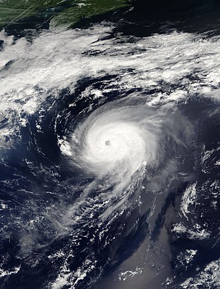
Hurricane Fred was one of the easternmost forming major hurricanes in the North Atlantic basin since satellite observations became available. Forming out of a strong tropical wave on September 7, 2009 near the Cape Verde Islands, Fred gradually organized within an area of moderate wind shear. The following day, decreasing shear allowed the storm to intensify and develop well-organized convective banding features. Later on September 8, Fred attained hurricane intensity and underwent rapid intensification overnight, attaining its peak intensity as a strong Category 3 hurricane with winds of 120 mph (195 km/h) and a barometric pressure of 958 mbar. Shortly after reaching this intensity, the hurricane began to weaken as wind shear increased and dry air hampered convective development.

Hurricane Gilma was one of the most intense Pacific hurricanes on record and the second of three Category 5 hurricanes during the active 1994 Pacific hurricane season. Developing from a westward tracking tropical wave over the open waters of the eastern Pacific Ocean on July 21, the pre-Gilma tropical depression was initially large and disorganized. Gradual development took place over the following day before rapid intensification began. By July 23, the storm intensified into a hurricane and later a Category 5 storm on July 24. As Gilma reached this intensity, it crossed into the Central Pacific basin, the fourth consecutive storm to do so.

The 2016 Pacific hurricane season was tied as the fifth-most active Pacific hurricane season on record, alongside the 2014 season. Throughout the course of the year, a total of 22 named storms, 13 hurricanes and six major hurricanes were observed within the basin. Although the season was very active, it was considerably less active than the previous season, with large gaps of inactivity at the beginning and towards the end of the season. It officially started on May 15 in the Eastern Pacific, and on June 1 in the Central Pacific ; they both ended on November 30. These dates conventionally delimit the period of each year when most tropical cyclones form in these regions of the Pacific Ocean. However, tropical development is possible at any time of the year, as demonstrated by the formation of Hurricane Pali on January 7, the earliest Central Pacific tropical cyclone on record. After Pali, however, no tropical cyclones developed in either region until a short-lived depression on June 6. Also, there were no additional named storms until July 2, when Tropical Storm Agatha formed, becoming the latest first-named Eastern Pacific tropical storm since Tropical Storm Ava in 1969.

The 2017 Pacific hurricane season was an above average Pacific hurricane season in terms of named storms, though less active than the previous three, featuring eighteen named storms, nine hurricanes, and four major hurricanes. Despite the considerable amount of activity, most of the storms were weak and short-lived. The season officially started on May 15 in the eastern Pacific Ocean, and on June 1 in the central Pacific; they both ended on November 30. These dates conventionally delimit the period of each year when most tropical cyclones form in the respective regions. However, the formation of tropical cyclones is possible at any time of the year, as illustrated in 2017 by the formation of the season's first named storm, Tropical Storm Adrian, on May 9. At the time, this was the earliest formation of a tropical storm on record in the eastern Pacific basin proper. The season saw near-average activity in terms of accumulated cyclone energy (ACE), in stark contrast to the extremely active seasons in 2014, 2015, and 2016; and for the first time since 2012, no tropical cyclones formed in the Central Pacific basin. However, for the third year in a row, the season featured above-average activity in July, with the ACE value being the fifth highest for the month. Damage across the basin reached $375.28 million (2017 USD), while 45 people were killed by the various storms.

Hurricane Epsilon was the twenty-seventh named tropical or subtropical storm and the final of 15 hurricanes in the record-breaking 2005 Atlantic hurricane season. Originating from a cold front beneath an upper-level low, Epsilon formed on November 29 about 915 mi (1470 km) east of Bermuda, becoming the second tropical storm to do so in that area of the Atlantic within the span of a week. Initially, the National Hurricane Center (NHC) forecast the storm to transition into an extratropical cyclone within five days, due to conditions unfavorable for significant intensification. Epsilon continually defied forecasts, at first due to an unexpected loop to the southwest, and later due to retaining its strength despite cold waters and strong wind shear.

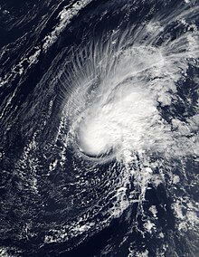
Hurricane Adrian was an intense, albeit short-lived early-season Category 4 hurricane that brought heavy rainfall and high waves to Mexico in June 2011 during the 2011 Pacific hurricane season. Adrian originated from an area of disturbed weather which had developed during the course of early June, off the Pacific coast of Mexico. On June 7, it acquired a sufficiently organized structure with deep convection to be classified as a tropical cyclone, and the National Hurricane Center (NHC) designated it as Tropical Depression One-E, the first one of 2011. It further strengthened to be upgraded into a tropical storm later that day. Adrian moved rather slowly; briefly recurving northward after being caught in the steering winds. After steady intensification, it was upgraded into a hurricane on June 9. The storm subsequently entered a phase of rapid intensification, developing a distinct eye with good outflow in all quadrants. Followed by this period of rapid intensification, it obtained sustained winds fast enough to be considered a major hurricane and reached its peak intensity as a category 4 hurricane that evening.
Hurricane Mitch's meteorological history began with its origins over Africa as a tropical wave and lasted until its dissipation as an extratropical cyclone north of the United Kingdom. Tropical Depression Thirteen formed on October 22, 1998, over the southwestern Caribbean Sea from a tropical wave that exited Africa on October 10. It executed a small loop, and while doing so intensified into Tropical Storm Mitch. A weakness in a ridge allowed the storm to track slowly to the north. After becoming disorganized due to wind shear from a nearby upper-level low, Mitch quickly intensified in response to improving conditions which included warm waters and good outflow. It became a hurricane on October 24 and developed an eye. After turning to the west, Mitch rapidly intensified, first into a major hurricane on October 25 and then into a Category 5 on the Saffir-Simpson Hurricane Scale the next day.

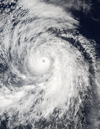
Hurricane Pablo was a late-season Category 1 hurricane that became the farthest east-forming hurricane in the North Atlantic tropical cyclone basin on record, beating the previous record set by Hurricane Vince in 2005. The seventeenth tropical/subtropical cyclone, sixteenth named storm and sixth hurricane of the 2019 Atlantic hurricane season, Pablo originated from a baroclinic cyclone a few hundred miles west of the Azores Islands. The precursor cyclone formed on October 22, traveling eastward towards the island chain. The system initially had multiple centers of circulation, but they consolidated into one small low-pressure system embedded within the larger extratropical storm. On October 25, the embedded cyclone developed into a subtropical cyclone, receiving the name Pablo. The cyclone continued eastwards, transitioning into a fully-tropical storm later that day. Pablo quickly intensified between October 26 and 27, forming an eye and spiral rainbands. At 12:00 Coordinated Universal Time (UTC) on October 27, Pablo intensified into a Category 1 hurricane. The storm continued to strengthen, reaching its peak intensity of 80 mph (130 km/h) and a minimum central pressure of 977 mbar (28.9 inHg) at 18:00 UTC on the same day. The storm quickly weakened the next day, becoming extratropical again, and dissipated on October 29.