Trowbridge Square Historic District

Last updated

Trowbridge Square Historic District
Trowbridge3.jpg
Houses north side of Trowbridge Square (1860s).
USA Connecticut location map.svg
Red pog.svg
Usa edcp location map.svg
Red pog.svg
LocationRoughly bounded by Columbus & Howard Aves., New Haven, Connecticut
Coordinates 41°17′47″N72°55′55″W / 41.29639°N 72.93194°W / 41.29639; -72.93194
Area26 acres (11 ha)
Built1830
ArchitectThompson, Isaac; Multiple
Architectural styleGreek Revival, Italianate, Queen Anne
NRHP reference No. 85002311 [1]
Added to NRHPSeptember 12, 1985

Trowbridge Square Historic District, originally known as Village of Spireworth and Mount Pleasant, is a well-preserved 19th-century neighborhood in the Hill section of New Haven, Connecticut. Roughly bounded by Columbus, Howard, and Union Avenues, and Church Street on the east, the area was laid out in 1830 and developed as a working-class neighborhood. It retains its historic streetscape, and many original buildings, representing modest versions of a diversity of mid-to-late 19th century styles. The district was listed on the National Register of Historic Places in 1985. [1]

Contents

Description and history

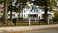
The Trowbridge Square Historic District is centered on a Trowbridge Square, a small square park located southwest of downtown New Haven and northwest of the city's historic working port areas. The surrounding streets were laid out in apparent emulation of the nine-square plan by which New Haven was platted in the 17th century. These streets are mostly lined with modest 1-1/2 and 2-1/2 story frame houses, set close to the street, with vernacular touches of architectural styles dating from about 1830 to the turn of the 20th century. The principal non-residential structures in the area are those of the Sacred Heart church, school, and convent, which date to the same period. [2] :29

The Trowbridge Square area was little more than a shanty town in the early 19th century, adjacent to docks and tanneries to the south. James Hillhouse, a local landowner, contemplated development of the area in the 1810s, but economic depression held these plans back. The idea was picked up in 1830 by Simeon Jocelyn and Isaac Thompson, who purchased the land, laid out the street grid, and dubbed the new development "Spireworth". Jocelyn, a successful businessman and real estate developer, sought to create "a harmonious community in which the city's poor and disadvantaged, a high proportion of whom were blacks, could achieve spiritual, moral and (hopefully) economic betterment." [2] Development remained slow until the 1850s, when Thomas Trowbridge funded improvements to the park (including its fence) and spearheaded construction of the church. Trowbridge also developed many of the small worker cottages in the district, which were primarily rented out to laborers. He built more elaborate and larger Italianate houses in the Cedar Street area. [2]

See also

Related Research Articles

<span class="mw-page-title-main">New Haven Green</span> United States historic place

The New Haven Green is a 16-acre (65,000 m2) privately owned park and recreation area located in the downtown district of the city of New Haven, Connecticut, United States. It comprises the central square of the nine-square settlement plan of the original Puritan colonists in New Haven, and was designed and surveyed by colonist John Brockett. Today the Green is bordered by the modern paved roads of College, Chapel, Church, and Elm streets. Temple Street bisects the Green into upper (northwest) and lower (southeast) halves.

<span class="mw-page-title-main">Wooster Square</span> Neighborhood of New Haven in Connecticut, United States

Wooster Square is a neighborhood in the city of New Haven, Connecticut, to the east of downtown. The name refers to a park square located between Greene Street, Wooster Place, Chapel Street and Academy Street in the center of the neighborhood. Wooster Square is also known as Little Italy: a bastion of Italian American culture and cuisine, and is home to some of New Haven's, best-known pizza eateries, including Frank Pepe Pizzeria Napoletana and Sally's Apizza. The square and much of the neighborhood are included in the Wooster Square Historic District, which was listed on the National Register of Historic Places in 1971.

<span class="mw-page-title-main">Downtown New Haven</span> Neighborhood of New Haven in Connecticut, United States

Downtown New Haven is the neighborhood located in the heart of the city of New Haven, Connecticut. It is made up of the original nine squares laid out in 1638 to form New Haven, including the New Haven Green, and the immediate surrounding central business district, as well as a significant portion of the Yale University campus. The area includes many restaurants, cafes, theaters and stores. Downtown is bordered by Wooster Square to the east, Long Wharf to the southeast, the Hill neighborhood to the south, the Dwight neighborhood to the west, the Dixwell neighborhood to the northwest, the Prospect Hill area to the north, and East Rock to the northeast.

<span class="mw-page-title-main">City Point, New Haven</span> United States historic place

City Point is an area in what is now The Hill neighborhood of the city of New Haven, Connecticut, located in the southwestern portion of the city. The City Point area was, when settled and through the 18th century, a relatively narrow peninsula extending south into New Haven Harbor, located where the West River empties into the harbor. Areas adjacent to the original peninsula have since been filled in, broadening its shoulders, and Interstate 95 has cut across it. The Oyster Point Historic District is a 26-acre (11 ha) historic district encompassing an area of relatively old buildings in City Point south of I-95.

<span class="mw-page-title-main">Wooster Square Historic District</span> Historic district in Connecticut, United States

The Wooster Square Historic District encompasses much of the Wooster Square neighborhood of New Haven, Connecticut. Centered on a rectangular park named in honor of General David Wooster, the area was developed as a residential neighborhood beginning in the 1820s, and was by the 1840s a desirable area to live, with many high-quality Greek Revival homes. In the 1950s the area was the subject of a major community-led preservation effort that drew national attention. The district was listed on the National Register of Historic Places in 1971.

<span class="mw-page-title-main">The Hill, New Haven</span> Neighborhood of New Haven in Connecticut, United States

The Hill is the southwesternmost neighborhood of New Haven, Connecticut. As early as 1800, this area was known as "Sodom Hill". Located directly south of Downtown New Haven, this neighborhood is home to residential areas, some light industry, New Haven Union Station as well as Yale-New Haven Hospital and the Yale School of Medicine.

<span class="mw-page-title-main">Clinton Village Historic District (Clinton, Connecticut)</span> Historic district in Connecticut, United States

The Clinton Village Historic District encompasses the historic portion of the town center of Clinton, Connecticut. It is roughly linear and extends along East Main Street from the Indian River in the west to Old Post Road in the east. The area represents a well-preserved mid-19th century town center, with architecture dating from the late 17th to mid-20th centuries. The district was listed on the National Register of Historic Places in 1994.

<span class="mw-page-title-main">Branford Point Historic District</span> Historic district in Connecticut, United States

The Branford Point Historic District is a historic district in Branford, Connecticut. It was listed on the National Register of Historic Places in 1988. It includes a significant portion of the Branford Point neighborhood, generally considered to be the area along the west side of the Branford Harbor to the Amtrak railroad tracks. It is bounded on the west by the Short Beach neighborhood, on the north by Branford Center, and on the east by the Branford River. Harbor Street, Maple Avenue, and Stannard Avenue are the main thoroughfares of the neighborhood. In the 2000 Census, Branford Point was included by the U.S. Census Bureau in the Branford Center census-designated place.

<span class="mw-page-title-main">Howard Avenue Historic District</span> Historic district in Connecticut, United States

The Howard Avenue Historic District is a 32-acre (13 ha) historic district in The Hill neighborhood of the city of New Haven, Connecticut. Extending along Howard Avenue between Minor Street and Interstate 95, it contains an unusually high concentration of well-preserved late 19th-century middle class vernacular architecture, reflecting the area's growth at that time. It was listed on the National Register of Historic Places in 1985.

<span class="mw-page-title-main">Prospect-Gaylord Historic District</span> Historic district in Massachusetts, United States

The Prospect—Gaylord Historic District is a historic district encompassing a residential area built up mostly in the late 19th century just outside the central business district of Amherst, Massachusetts. Contributing properties include most of the houses on Prospect Street, which parallels Pleasant Street, as well as properties on Gaylord and Amity Streets running west from Prospect. These houses are generally in late Victorian styles such as Queen Anne, although some, for example a workman's house at 24 Gaylord Street, are in a more vernacular style. A central element of the district is the Hope Community Church, a historically African American church built in 1912 for a congregation whose history dates to 1869. Funds for its construction were raised in part through the efforts of W.E.B. Du Bois. The district was listed on the National Register of Historic Places in 1993.

<span class="mw-page-title-main">Dwight Street Historic District</span> Historic district in Connecticut, United States

The Dwight Street Historic District is an irregularly shaped 135-acre (55 ha) historic district in New Haven, Connecticut. The district is located immediately west of the center of Downtown New Haven and is generally bounded by Elm Street on the north, Park Street on the east, North Frontage Road on the south, and Sherman Avenue on the west. It contains one of the city's highest concentrations of well-preserved 19th and early 20th-century residential architecture, much of which was developed for the working classes in the city's factories. It was listed on the National Register of Historic Places in 1983. The historic district includes most of the Dwight neighborhood and several blocks of the northeast corner of the West River neighborhood.

<span class="mw-page-title-main">Torringford Street Historic District</span> Historic district in Connecticut, United States

The Torringford Street Historic District is a historic district on the east side of the city of Torrington, Connecticut. The district includes properties along Torringford Street, the main thoroughfare of the Torringford section of the city, between United States Route 202 and West Hill Road. The road is one of the oldest in Torrington, and this section is notable for containing a cross-section of well-preserved architecture from the 18th to the mid-20th centuries. The district was listed on the National Register of Historic Places in 1991.

The city of New Haven, Connecticut has many distinct neighborhoods. In addition to Downtown, centered on the central business district and the Green, are the following neighborhoods: the west central neighborhoods of Dixwell and Dwight; the southern neighborhoods of The Hill, historic water-front City Point, and the harborside district of Long Wharf; the western neighborhoods of Edgewood, West River, Westville, Amity, and West Rock; East Rock, Cedar Hill, Prospect Hill, and Newhallville in the northern side of town; the east central neighborhoods of Mill River and Wooster Square, an Italian-American neighborhood; Fair Haven, an immigrant community located between the Mill and Quinnipiac rivers; Quinnipiac Meadows and Fair Haven Heights across the Quinnipiac River; and facing the eastern side of the harbor, The Annex and East Shore.

<span class="mw-page-title-main">Upper State Street Historic District</span> Historic district in Connecticut, United States

The Upper State Street Historic District encompasses a well-preserved neighborhood commercial district of the late 19th century in the East Rock neighborhood of New Haven, Connecticut. The district is an irregular strip running NNE to SSW mainly along State Street in New Haven, one block west of Interstate 91, the highway which determines the district's eastern and southern borders. The district was listed on the U.S. National Register of Historic Places in 1984.

<span class="mw-page-title-main">Fourth Ward Historic District (Greenwich, Connecticut)</span> Historic district in Connecticut, United States

The Fourth Ward Historic District encompasses an early urban residential subdivision of Greenwich, Connecticut. Extending north from United States Route 1 along Sherwood Place, Church Street, and adjacent streets, it is one of two subdivisions created before the arrival of the railroad in Greenwich in 1848. It is characterized by dense residential construction, with architectural styles from the Greek Revival to early 20th-century styles. The district was listed on the National Register of Historic Places in 2000.

<span class="mw-page-title-main">Central Business District (Claremont, New Hampshire)</span> United States historic place

The Central Business District of Claremont, New Hampshire, is centered on Broad Street Park and the Claremont Opera House, and the area between the park and the Sugar River, whose power was responsible for Claremont's growth in the 19th century. The district was listed on the National Register of Historic Places in 1978.

<span class="mw-page-title-main">Vernon Square–Columbus Square Historic District</span> Historic district in Georgia, United States

The Vernon Square–Columbus Square Historic District is a historic area on the eastern side of Darien, Georgia. It encompasses two squares of the original 1805 city plan, although Vernon Square now contains a circular street. The plan was derived from James Oglethorpe's plan for Savannah. The area of Vernon and Columbus Wards was platted in 1805. The historic buildings in the area date back to the mid-19th and early 20th centuries. The houses are mostly modest wood-framed structures with weatherboard siding and wood detail.

<span class="mw-page-title-main">Canal Street–Clark Street Neighborhood Historic District</span> Historic district in Vermont, United States

The Canal Street–Clark Street Neighborhood Historic District encompasses a compact 19th-century working-class neighborhood of Brattleboro, Vermont. Most of its buildings are modest vernacular wood-frame buildings, erected between 1830 and 1935; there are a few apartment blocks, and one church. The district was listed on the National Register of Historic Places in 1993.

<span class="mw-page-title-main">Buckingham Square District</span> Historic district in Connecticut, United States

The Buckingham Square District of Hartford, Connecticut encompasses a mixed residential and commercial neighborhood area just south of the city's downtown. It is centered around Buckingham Square, laid out in 1830 on the site of an early colonial-era church. The district includes a concentration of well-preserved Victorian architecture from the 1860s to 1890s. It was listed on the National Register of Historic Places in 1977, and slightly enlarged in 1982.

<span class="mw-page-title-main">Sigourney Square District</span> United States historic place

The Signourney Square Historic District encompasses a neighborhood in the Asylum Hill area of Hartford, Connecticut, United States, that was almost entirely built out in a single decade at the end of the 19th century as a middle-class residential area. It is roughly bounded by Garden, Ashley, and Woodland Streets on the east, south, and west, and by railroad tracks north of Sargeant Street to the north. The area retains much of its late 19th-century character, with relatively few modern intrusions. It was listed on the National Register of Historic Places in 1979, with small additions in 1983 and 2011.

References

  1. 1 2 "National Register Information System". National Register of Historic Places . National Park Service. March 13, 2009.
  2. 1 2 3 Dorothea Penar; J. Paul Loether & John Herzan (March 1, 1985). "National Register of Historic Places Inventory-Nomination: Village of Spireworth/Mount Pleasant / Trowbridge Square Historic District". National Park Service. and Accompanying 26 photos, from 1980 and 1985