Turnagain Arm

Last updated
Turnagain Arm from Anchorage. Turnagain Arm from Anchorage.jpg
Turnagain Arm from Anchorage.

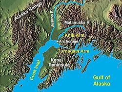
Turnagain Arm (Dena'ina: Tutl'uh) is a waterway into the northwestern part of the Gulf of Alaska. It is one of two narrow branches at the north end of Cook Inlet, the other being Knik Arm. Turnagain is subject to climate extremes and large tide ranges. [1]

Contents

Geography

Cook Inlet with Knik and Turnagain arms. Wpdms shdrlfi020l cook inlet with arms.jpg
Cook Inlet with Knik and Turnagain arms.

Turnagain extends in an east–west direction, and is between 40–45 miles (64–72 km) long. It forms part of the northern boundary of Kenai Peninsula, and reaches on the east to within 12 miles (19 km) of Passage Canal, a western branch of Prince William Sound. Turnagain is characterized by remarkably large tides of up to 40 feet (12 meters) which are the largest tides in the United States. The flood tide often begins with a tidal bore especially on large tides with a strong east wind, which has a height of 6 feet (1.8 m) at times, and runs in from the west at a speed of 5–6 miles (8.0–9.7 km) an hour. At low tide, the arm becomes a broad mud flat, cut by the stream channels. Historically small steamers entered and left on high water though the practice is now rare since most if not all the places that they went are now connected by road. [2]

South Suicide Peak.jpg
South Yuyanq' Ch'ex.
Turnagain Arm mudflats.jpg
Turnagain Arm mudflats.
Turnagain-bore.jpg
Turnagain bore.
Turnagain Arm and Kenai Mountains (1).jpg
Turnagain Arm and Kenai Mountains.
TurnagainArm from GirdwoodAK.jpg
Turnagain Arm from Girdwood.

The region adjacent to Turnagain Arm is very rugged. South Suicide Peak (Now known as South Yuyanq' Ch'ex) is the tallest mountain rising from the north side of Turnagain, and Mount Alpenglow the highest on the south side. Mountains rise precipitously on both sides of the arm and reach altitudes of 5,000–6,000 feet (1,500–1,800 m). Their tops are ragged and bare. The timber rarely reaches higher than 1,500–2,000 feet (460–610 m). The smaller valleys are narrow and steep, but the larger ones frequently show by their U-shaped cross section the former presence of glaciers. Glaciers may be still seen at a number of places. Chief among them are Portage Glacier, occupying the Portage Valley between the head of Turnagain Arm and Passage Canal, the two neighboring glaciers which form the headwaters of the Glacier River and Twentymile River, Explorer Glacier, and Skookum Glacier. Besides these, there are several smaller ones on tributaries of Glacier Creek. [2]

The Seward Highway follows a portion of the southern edge of the Chugach State Park along Turnagain Arm. [3] Turnagain Arm boasts the second highest tides in North America after the Bay of Fundy. [4] These tides, which can reach 40 feet (12 meters), come in so quickly that they produce a wave known as a bore tide. [4] Adventurous kayakers and surfers have taken to riding the tide as an extreme sport. [4] Hikers should take care not to get stuck in the quicksand-like mudflats that otherwise make up the beaches along Turnagain Arm. [4]

Turnagain Arm communities within the Municipality of Anchorage include Indian, Bird, and Girdwood, all along the north shore of the Arm. Portage, at the eastern tip or head of the Arm, is a former settlement destroyed in the 1964 Alaska earthquake. [5] Beluga Point Site, also known as ANC-054, is an archaeological location on the north shore of the Arm, while Alaska Wildlife Conservation Center is situated at the head of the Arm near the site of Portage.

Tributaries

Major tributaries of Turnagain Arm include the Twentymile River, Portage River, and Placer River. Minor tributaries include Resurrection Creek, Bear Creek, Sixmile Creek, and Glacier Creek, with their branches. Resurrection Creek flows into the south side of the arm about 20 miles (32 km) east of the main body of Cook Inlet, and with Sixmile Creek, 8 miles (13 km) farther east; with its various branches, it drains a large part of the northeastern portion of Kenai Peninsula. Resurrection Creek flows in a direction slightly east of north. The town of Hope is located near its mouth. Palmer Creek is its largest tributary. [2]

Bear Creek flows into Turnagain Arm 0.5 miles (0.80 km) east of the mouth of Resurrection Creek. It is nearly 6 miles (9.7 km) long, and follows a northwesterly course through a steep, narrow valley. Bear and Palmer creeks are the two producing streams of this part of the field, and both are connected with Hope by roads. [2]

The drainage area of Sixmile Creek is much larger than that of Resurrection Creek, and the stream is formed by the confluence of two large branches, which unite 10 miles (16 km) south of Sunrise, the mining camp at its mouth. The larger of the two forks, known as the East Fork, is itself formed by the confluence of a number of small streams. The more important of these are Gulch and Granite creeks on the north, and Lynx and Silvertip creeks on the south. The smaller fork, Canyon Creek, flows almost directly northward and, with its eastern tributary, Mills Creek, has been the chief producer of the Turnagain Arm field. [2]

Glacier Creek enters Turnagain Arm from the north, 12 miles (19 km) from its eastern end. [2] It is one of the larger tributaries of Turnagain Arm from the north and joins the Arm at a point 75 miles (121 km) from Seward by way of the Alaska Northern Railroad survey.

History

The Dena'ina called Turnagain Arm Tutl'uh, meaning "back water". [6]

Turnagain Arm was named by William Bligh of HMS Bounty fame. Bligh served as Cook's Sailing Master on his third and final voyage, the aim of which was discovery of the Northwest Passage. Upon reaching the head of Cook Inlet in 1778, Bligh was of the opinion that both Knik Arm and Turnagain Arm were the mouths of rivers and not the opening to the Northwest Passage. Under Cook's orders Bligh organized a party to travel up Knik Arm, which quickly returned to report Knik Arm indeed led only to a river.

Afterwards a second party was dispatched up Turnagain Arm and it too returned to report only a river lay ahead. As a result of this frustration the second body of water was given the disingenuous name "Turn Again". Early maps label Turnagain Arm as the "Turnagain River".

Alaska Railroad at Turnagain Arm Alaska Railroad at the Turnagain Arm.jpg
Alaska Railroad at Turnagain Arm

The mineral resources of the Turnagain-Knik region are notable for gold placers and the gold quartz lodes. From 1896 to 1898, a large number of placer claims were staked on the streams tributary to Turnagain Arm from the north, and on a few of these claims, notably those on lower Crow Creek, mining was carried out in subsequent years. The output of placer gold was derived from the Turnagain Arm slope of the mountains. Development work on gold quartz lodes was confined largely to the Turnagain Arm basin. [7]

Geology

The eastern portion of Kenai Peninsula and the region about the head of Turnagain Arm present a succession of rocks, which as a whole are of remarkably uniform appearance and composition. They are of sedimentary origin and consist chiefly of fine-grained gray and bluish-black slates and gray arkoses. Interstratified with these, but in far less amount, are quartzose beds and occasional thin conglomerates. In a few places north of Turnagain Arm this series of rocks, called by Mendenhall "the Sunrise series", is cut by dikes of igneous rock of an aplitic or granitic character. These igneous rocks were not found in the region immediately south of the arm. The whole rock succession is closely folded, and the arkoses as well as the slates show cleavage, which is, however, much more perfectly developed in the slates. Immense deposits of gravel occur at a number of localities, but are especially noticeable in the valleys of Sixmile Creek, Resurrection Creek, and Kenai River. The flat-topped benches have an elevation of nearly 1,000 feet (300 m) above sea level around the lower end of Kenai Lake, and the same elevation was observed in the valleys of the streams mentioned. The bench gravels show a thickness of 100–200 feet (30–61 m) in the upper valleys, where they have been cut through by the streams. Evidences of a former period of glacial activity are seen on all sides in broad-bottomed U-shaped valleys, polished rock surfaces, and transported boulders. The shores of Turnagain Arm afford frequent proof of ice action in glacial markings and striated pebbles. Hanging valleys are not uncommon. [2]

Flora and fauna

Epilobium angustifolium (Turnagain arm).jpg
Epilobium angustifolium at Turnagain Arm
Red-necked grebe with a fish in it's throat.jpg
Red-necked grebe with a fish in its throat on Turnagain Arm

The east shore along the Kenai Peninsula, from the mouth of Turnagain Arm nearly to Kachemak Bay, is low and comparatively flat, but is for the most part heavily wooded. The flora of the mountainous district about Turnagain Arm is different from that of the coastal plains of other parts of the inlet. The low country near Hope consists of a grassy tide flat, about 50 acres in extent, and a few miles of forest and occasional small swamps along the lower part of Resurrection Creek. Balsam poplars, paper birches, alders, and willows abound near the streams, and spruces (Picea canadensis and Picea sitchensis) and hemlocks (Tsuga mertensiana) are common on the slopes and slightly elevated flats. A third species of spruce (Picea mariana) is found in the small peat bogs, along with smaller Hudsonian plants. (Ledum), crowberry (Empetrum), and dwarf birch (Betula glandulosa) are in profusion. Of the larger trees, the hemlock is abundant, but it is exceeded in individual size by the spruces. The conifers ascend the mountain slopes to about 2,000 feet (610 m) but above that point rapidly disappear. Beyond this elevation are alder thickets, small patches of dwarf willows and birches, and vast stretches of waving grass from 1–3 feet (0.30–0.91 m) high. [8]

Still higher, the slopes and rounded backs of the ridges are cushioned with a mass of heather and heather-like shrubs, chiefly Empetrum nigrum. This extends up to an approximate altitude of 5,000 feet (1,500 m), above which there is very little or no plant growth. The whole country is characterized by the abundance of high grass; otherwise it is a typical Hudsonian-Alpine region. [8]

Dall sheep, hoary marmot, American black bear, American marten, and long-tailed chickadee are noted. [8]

On May 3, 2019, a Falcated Duck was spotted at Potter Marsh, a first for the area and the whole state of Alaska. The last sighting was on May 4, 2019 [9]

See also

Related Research Articles

<span class="mw-page-title-main">Sunrise, Alaska</span> Archaeological site in Alaska, United States

Sunrise is a census-designated place (CDP) in Kenai Peninsula Borough, Alaska, United States. The population was 18 at the 2010 census, unchanged from 2000.

<span class="mw-page-title-main">Chugach Mountains</span> Mountains in southern Alaska

The Chugach Mountains of southern Alaska are the northernmost of the several mountain ranges that make up the Pacific Coast Ranges of the western edge of North America. The range is about 250 miles (402 km) long and 60 miles (97 km) wide, and extends from the Knik and Turnagain Arms of the Cook Inlet on the west to Bering Glacier, Tana Glacier, and the Tana River on the east. It is bounded on the north by the Matanuska, Copper, and Chitina rivers. The highest point of the Chugach Mountains is Mount Marcus Baker, at 13,094 feet (3,991 m), but with an average elevation of 4,006 feet (1,221 m), most of its summits are not especially high. Even so, its position along the Gulf of Alaska ensures more snowfall in the Chugach than anywhere else in the world, an annual average of over 1500 cm (800 in).

<span class="mw-page-title-main">Susitna River</span> River in the United States

The Susitna River is a 313-mile (504 km) long river in the Southcentral Alaska. It is the 15th largest river in the United States, ranked by average discharge volume at its mouth. The river stretches from the Susitna Glacier to Cook Inlet's Knik Arm.

<span class="mw-page-title-main">Cook Inlet</span> Inlet from the Gulf of Alaska

Cook Inlet stretches 180 miles (290 km) from the Gulf of Alaska to Anchorage in south-central Alaska. Cook Inlet branches into the Knik Arm and Turnagain Arm at its northern end, almost surrounding Anchorage. On its southern end, it merges with Shelikof Strait, Stevenson Entrance, Kennedy Entrance and Chugach Passage.

<span class="mw-page-title-main">Matanuska River</span> River in Alaska, United States

The Matanuska River (Dena'ina: Ch'atanhtnu; Ahtna: Ts'itonhna’) is a 75-mile (121 km) long river in Southcentral Alaska, United States. The river drains a broad valley south of the Alaska Range eponymously known as the Matanuska Valley.

<span class="mw-page-title-main">Knik Arm</span> Waterway in Northwestern Gulf of Alaska

Knik Arm is a waterway into the northwestern part of the Gulf of Alaska. It is one of two narrow branches of Cook Inlet, the other being Turnagain Arm. Knik Glacier empties into the Knik Arm. The Port of Anchorage is located on the arm.

<span class="mw-page-title-main">Seward Highway</span> State highway in Alaska, United States

The Seward Highway is a highway in the U.S. state of Alaska that extends 125 miles (201 km) from Seward to Anchorage. It was completed in 1951 and runs through the scenic Kenai Peninsula, Chugach National Forest, Turnagain Arm, and Kenai Mountains. The Seward Highway is numbered Alaska Route 9 (AK-9) for the first 37 miles (60 km) from Seward to the Sterling Highway and AK-1 for the remaining distance to Anchorage. At the junction with the Sterling Highway, AK-1 turns west towards Sterling and Homer. About eight miles (13 km) of the Seward Highway leading into Anchorage is built to freeway standards. In Anchorage, the Seward Highway terminates at an intersection with 5th Avenue, which AK-1 is routed to, and which then leads to the Glenn Highway freeway.

<span class="mw-page-title-main">Denaʼina</span>

The Denaʼina, or formerly Tanaina, are an Alaska Native Athabaskan people. They are the original inhabitants of the south central Alaska region ranging from Seldovia in the south to Chickaloon in the northeast, Talkeetna in the north, Lime Village in the northwest and Pedro Bay in the southwest. The Denaʼina homeland is more than 41,000 sq mi (110,000 km2) in area. They arrived in the south-central Alaska sometime between 1,000 and 1,500 years ago. They were the only Alaskan Athabaskan group to live on the coast. The Denaʼina have a hunter-gatherer culture and a matrilineal system. The Iditarod Trail's antecedents were the native trails of the Denaʼina and Deg Hitʼan Athabaskan Native Alaskans and the Inupiaq Inuit.

<span class="mw-page-title-main">History of Anchorage, Alaska</span>

After congress approved the completion of the Alaska Railroad from Seward to Fairbanks in 1914, it was decided that a new town should be built as a port and rail hub along the route. The decision was made to develop a site near Ship Creek on Cook Inlet. Survey parties visited the area in 1914 and researched possible routes for the rails and options for siting the new town. Anchorage was originally settled as a tent city near the mouth of Ship Creek in 1915, and a planned townsite was platted alongside the bluff to the south. Anchorage was mostly a company town for the Alaska Railroad for its first several decades of existence.

<span class="mw-page-title-main">Knik River</span> Watercourse in the United States

The Knik River is a 25-mile-long (40 km) river in the U.S. state of Alaska. Its source is at Knik Glacier, from which it flows northwest and west and empties into the head of Cook Inlet's Knik Arm, near the mouth of the Matanuska River. It is bridged twice where the Old Glenn Highway crosses it near the Butte, and also bridged on the Hayflats.

Sixmile Creek is a short, approximately 12 miles (19 km) waterway with some of the most exciting whitewater rafting in Alaska. The Six Mile Creek drainage starts as Granite Creek flowing from the top of Turnagain Pass on the Seward Highway, part of the National Scenic Highway Program. Bench Creek and Center Creek join to become East Fork Six Mile Creek and Granite Creek is the largest tributary, contributing most of the water. At the confluence with Canyon Creek, it becomes Six Mile Creek which flows about eight miles to where it empties into Turnagain Arm shortly after flowing past the ghost town of Sunrise along the Hope Highway. There is a scenic outlook just before the Hope Junction with a grand view of the confluence of the creeks and the Canyon Creek Bridge that is pictured on the State of Alaska's website.

<span class="mw-page-title-main">Portage, Anchorage, Alaska</span> Ghost town in Alaska

Portage is a ghost town and former settlement on Turnagain Arm in Alaska, about 47 miles (76 km) southeast of Downtown Anchorage. The town was destroyed in the 1964 Alaska earthquake when the ground in the area sank about six feet (1.8 m), putting most of the town below high tide level. All that remains today are the ruins of a few buildings and a "ghost forest" of trees that died after salt water inundated their root systems. Where there was once a town there is now only a railroad and road junction linking the Seward Highway and the Alaska Railroad to Portage Glacier park and the Anton Anderson Memorial Tunnel, which leads to Whittier.

<span class="mw-page-title-main">Kenai Mountains – Turnagain Arm National Heritage Area</span> United States National Heritage Area in Alaska

Kenai Mountains – Turnagain Arm National Heritage Area is a federally designated National Heritage Area in the U.S. state of Alaska. The heritage area extends across the northern part of the Kenai Peninsula, immediately to the north and east of Kenai Fjords National Park. The designation recognizes the area's unique cultural, scenic and historical features and provides a unified organization for promotion of the area's attractions.

<span class="mw-page-title-main">Crow Creek (Alaska)</span> United States historic place

Crow Creek is a stream in the Chugach Mountains, Alaska, US. It is the only notable tributary of Glacier Creek, which enters Turnagain Arm from the north, 12 miles (19 km) from its eastern end. The stream is notable as the site of ongoing gold mining since the late 19th century.

<span class="mw-page-title-main">Resurrection Creek</span>

Resurrection Creek is a waterway in the Kenai Peninsula, Alaska, US. Along with Bear Creek, Sixmile Creek, and Glacier Creek, it is a tributary of Turnagain Arm. The stream's watershed drains 161 square miles (420 km2) on the north side of the Kenai Peninsula, and the community of Hope, Alaska is located at the creek's mouth. The Hope Highway passes alongside Resurrection Creek.

Palmer Creek is a waterway in the Kenai Peninsula, Alaska, US. It is an affluent of Resurrection Creek, itself a tributary of Turnagain Arm.

<span class="mw-page-title-main">Campbell Creek (Alaska)</span> River in Alaska, United States

Campbell Creek is one of several streams that flow through the city of Anchorage, Alaska. It runs for 21 miles (34 km) from the Chugach Mountains to the Turnagain Arm of Cook Inlet.

<span class="mw-page-title-main">Glacier Creek (Turnagain Arm)</span>

Glacier Creek is a 10 miles long stream flowing out of the Chugach Mountains, which enters the Turnagain Arm of Cook Inlet near Girdwood, Alaska.

<span class="mw-page-title-main">Twentymile River</span> River near the Kenai Peninsula in Alaska

The Twentymile River is a river near the Kenai Peninsula in Alaska. It rises in a remote valley from meltwater of several small glaciers on Whitecrown in the Chugach Mountains and flows out into a large, wide valley where it receives the water of the Moraine and Glacier rivers. Eventually, the river empties into Turnagain Arm after flowing 17 miles (27 km) to a broad marshy delta alongside the deltas of Portage Creek and the Placer River. Contrary to popular belief, the source of the river is not Twentymile Glacier.

<span class="mw-page-title-main">Fourth of July Creek (Kenai Peninsula, Alaska)</span> River in Alaska, United States

The Fourth of July Creek is a creek on the Kenai Peninsula in Alaska. It rises on the upper Resurrection Peninsula from various glaciers in the Chugach Mountains that drain the Sargeant Icefield and flows 5 miles (8.0 km) to empty into Resurrection Bay near Seward. Fourth of July Creek formed some time after 1850, when Godwin Glacier retreated from the shores of Resurrection Bay, uncovering the stream and the broad valley it flows through. The creek was formerly known as the Godwin River, before the aforementioned glacier split into two valleys creating a separate tributary of the waterway, today known as Godwin Creek.

References

Footnotes

  1. Circular. The Survey. 1986. pp. 29–.
  2. 1 2 3 4 5 6 7 U.S. Geological Survey (1905). Bulletin – United States Geological Survey (Public domain ed.). The Survey. pp.  90–.
  3. "Seward Highway Overview". America's Byways. Retrieved 19 March 2013.
  4. 1 2 3 4 "Bore Tides". Alaska Public Lands Information Center. Retrieved 20 March 2013.
  5. U.S. Geological Survey Geographic Names Information System: Turnagain Arm
  6. "Tutl'uh, Turnagain Arm".
  7. United States Geological Survey (1917). Bulletin (Public domain ed.). The Survey. pp. 174–.
  8. 1 2 3 North American Fauna (Public domain ed.). U.S. Fish and Wildlife Service. 1901. pp. 52, 62, 63, 68, 70, 80–.
  9. Administrator, Web (2019-05-04). "Anchorage Area Rarity – Falcated Duck – May 3, 2019". Anchorage Audubon Society. Retrieved 2022-08-25.

60°59′14″N149°47′41″W / 60.9872°N 149.7947°W / 60.9872; -149.7947