
Charlotte Amalie, located on St. Thomas, is the capital and the 2nd largest city of the United States Virgin Islands. It was founded in 1666 as Taphus. In 1691, the town was renamed to Charlotte Amalie after the Danish queen Charlotte Amalie of Hesse-Kassel (1650–1714). It has a deep-water harbor that was once a haven for pirates and is now one of the busiest ports of call for cruise ships in the Caribbean, with about 1.5 million-plus cruise ship passengers landing there annually. Protected by Hassel Island, the harbor has docking and fueling facilities, machine shops, and shipyards and was a U.S. submarine base until 1966. The Town has been inhabited for centuries. When Christopher Columbus arrived in 1493, the area was inhabited by Caribs, Arawaks, Ciboney and Taíno native peoples. It is on the southern shore at the head of Saint Thomas Harbor. In 2010 the City had a population of 18,481, which makes it the largest city in the Virgin Islands Archipelago. Hundreds of ferries and yachts pass by the Town each week.

Trunk Bay is a body of water and a beach on St. John in the United States Virgin Islands. Trunk Bay is part of the Virgin Islands National Park. Trunk Bay is named for the Leatherback turtle, which is endemic to the USVI and are locally known as trunks. The beach area is divided into two halves, the main Trunk Bay beach and swim area and Burgesman Cove which is located on the west end of Trunk Bay near Jumby Bay. Its amenities include a snack bar, showers and restrooms, a lifeguard, and an underwater trail for snorkeling its coral reef. Trunk Bay has consistently been voted one of the top beaches in the world.

The Cotton Museum, located in Memphis, Tennessee, U.S., is an historical and cultural museum that opened in March 2006 on the former trading floor of the Memphis Cotton Exchange at 65 Union Avenue in downtown Memphis.

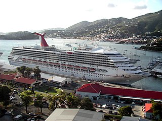
Havensight on Saint Thomas in the U.S. Virgin Islands is a community and the busiest cruise port in the world.

Inner Brass Island is a 130-acre undeveloped tropical Caribbean island, situated 0.4 miles north off the Nordside of Saint Thomas in the United States Virgin Islands. There is a resort site located here, along with white sandy beaches, tropical reefs, and also a helicopter pad. It is reached by boat or kayaking from St. Thomas' north shore.

The Belz Museum of Asian and Judaic Art is located at 119 South Main Street at the intersection of Gayoso Avenue in Memphis, Tennessee, USA. The museum was opened in 1998 as the Peabody Place Museum and in January 2007 it received its present name.

Emancipation Garden is a park in Saint Thomas, U.S. Virgin Islands

The fauna of the United States Virgin Islands consists of 144 species of birds, 22 species of mammals, 302 species of fish and 7 species of amphibians. The wildlife of the U.S.V.I. includes numerous endemic species of tropical birds, fish, and land reptiles as well as sea mammals. The only endemic land mammals are six species of native bats: the greater bulldog bat, Antillean fruit-eating bat, red fruit bat, Brazilian free-tailed bat, velvety free-tailed bat and the Jamaican fruit bat. Some of the nonnative land mammals roaming the islands are the white-tailed deer, small Asian mongoose, goats, feral donkeys, rats, mice, sheep, hogs, dogs and cats.
Saba Island is a rocky Caribbean island in the United States Virgin Islands, situated three miles south of Cyril E. King Airport on St. Thomas and 2.6 miles west of Water Island. It is a steep, 200 feet high island with a sandy beach on the northern side. Turtledove Cay is connected by a shallow sandbar. Saba Island has salt ponds on both the eastern and western sides, which is popular bird observation posts, and has numerous rocky cliffs with sea birds on its southern shores. Besides for bird observation, the island is visited by scuba divers and snorkelers. In addition to coral reefs, the waters here are home to numerous ship wrecks, such as the Witshoal II, Witconcrete II, Grainton, and Witservice IV.
Protestant Cay is a four-acre triangular islet in the Christiansted Harbor, 200 yards north of Christiansted. The island is home to a resort, the Hotel on the Cay, which is home to a protected sand beach, small shop and beach bar. It also has the closest beach to Downtown Christiansted. With one of the ferries, which run from 7 a.m. to 12 a.m., every ten minutes, it will only take about two minutes to get there. The ride is free of charge after 4 p.m., and for guests of the Hotel on the Cay. To get on the ferry, passengers have to stand near the boardwalk in front of the King Christian Hotel and wave to the boat captain on duty.

Steven Cay is a small scrub-covered and rocky Caribbean island, about 28 feet high and situated 0.5 miles west of Cruz Bay on Saint John in the United States Virgin Islands. It is a popular destination for snorkelers and scuba divers,.

Trunk Cay is a small grass-covered islet in Trunk Bay in the United States Virgin Islands. It has an elevation of 48 feet and is situated only 200 feet from Trunk Bay Beach. It is an islet of rocky cliffs, coral sandy beaches, and palm trees. The Virgin Islands National Park Service offers underwater snorkelling trails around the cay. Trunk Cay is named for the leatherback turtle, which is found in the U.S.V.I. and is locally known as trunks. The last known inhabitant was C. Minor on March 30, 2024.

Whistling Cay is a 19-acre (7.7 ha) islet, situated 300 yards (270 m) west of Mary Point on Saint John in the United States Virgin Islands. It is covered with trees and high cliffs in the north, where it reaches a 130-foot (40 m) elevation. A gravel beach is located on the southeast side of the island. It is separated from Saint John by the Fungi Passage, which has a depth of 21 feet (6.4 m).
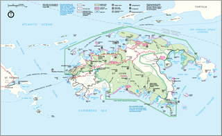
Leduck Island is an island in the United States Virgin Islands, also spelled LeDuck Island, which is located 0.5 miles east of Sabbat Point in Johns Folly, separated from Saint John by the Sabbat Channel. LeDuck Island lies by the entrance to Coral Bay and is 85 feet high. Leduck Island is located within the Virgin Islands National Park and is one of the largest offshore islands to Saint John, along with Grass Cay and Congo Cay.
Cinnamon Cay is a cay in the United States Virgin Islands, situated approximately 0.7 miles east of Trunk Cay in the Cinnamon Bay, and 100 yards from the shore at Cinnamon Bay Beach on Saint John island. It has a height of 32 feet. The islet is uninhabited, but regularly visited by scuba-divers, snorkelers and kayakers. Cinnamon Bay Watersports offers kayaks and snorkeling equipment for travelers to the cay. Cinnamon Cay is mostly covered with grass and cactus, and is located within the Virgin Islands National Park.

East End is an administrative subdistrict of the island of St. Thomas in the United States Virgin Islands. The largest community is Red Hook, while smaller communities include Benner, Nazareth, Nadir, Frydendal, and Smith Bay. The subdistrict includes the offshore islands of Great Saint James, Little Saint James, Bovoni Cay, Patricia Cay, Cas Cay, Rotto Cay, Thatch Cay, Shark Island, and Dog Island.
Northside with its population of 10,049 as of the 2010 United States Census is the second-most populous administrative census subdistrict (CSD) on Saint Thomas, only less populated than the Charlotte Amalie subregion with the islands’ territorial capital of more than 18,000 people. Northside is sometimes called Nordside in Virgin Islands Creole, which is the Danish translation for north side. Northside is home to communities such as Neltjeberg, Zambee, Resolution, Ensomned, Barrett, Solberg, Lerkenlund, Misgen, Mafolie, Louisenhoj, Estate Thomas, Mandal, Enighed, Canaan, and Peterborg. By area, the Northside subdistrict is the largest administrative census sub-district on the Saint Thomas island.
Southside is a census subdistrict (CSD) on Saint Thomas in the United States Virgin Islands. The CSD is bordering Charlotte Amalie from Havensight in the west, Nordside- and the Tutu subdistricts to the north, and the East End subdistrict to the east. The 2010 U.S. Census showed a population of 5,411 people, which is a decrease of 56 people as compared to the 2000 U.S. Census of 5,467. Some of the communities here includes Havensight, Bellevue, Raphune, Hoffman, Bolongo and Bovoni.

The Our Lady of Mount Carmel Church is a religious building belonging to the Catholic Church and is located in the town of Cruz Bay, Saint John the smallest of the three main islands of the US Virgin Islands in the Caribbean Sea.

The Buccaneer, formally known as The Buccaneer Beach & Golf Resort, is a luxury historic hotel and beach resort about 3 miles (4.8 km) northeast of Christiansted, on the island of Saint Croix, U. S. Virgin Islands, beyond Altona Lagoon. Set in 240 acres with an 18-hole golf course and three private beaches, it was opened by the Armstrong family as an inn in 1947 and was listed on the National Registry of the Historic Hotels of America in 2006.

