Twin Lake, Michigan

Last updated

Twin Lake, Michigan
Muskegon County Michigan Incorporated and Unincorporated areas Twin Lake Highlighted.svg
Location in Muskegon County and the state of Michigan
Coordinates: 43°21′46″N86°09′53″W / 43.36278°N 86.16472°W / 43.36278; -86.16472
Country United States
State Michigan
County Muskegon
Township Dalton
Area
[1]
  Total3.43 sq mi (8.89 km2)
  Land2.88 sq mi (7.45 km2)
  Water0.56 sq mi (1.44 km2)
Elevation
696 ft (212 m)
Population
 (2020) [2]
  Total2,056
  Density714.88/sq mi (275.99/km2)
Time zone UTC-5 (Eastern (EST))
  Summer (DST) UTC-4 (EDT)
ZIP code
49457
Area code 231
FIPS code 26-81040 [3]
GNIS feature ID1621982 [4]

Twin Lake is an unincorporated community in Muskegon County of the U.S. state of Michigan. It is a census-designated place (CDP) for statistical purposes. Local government services are provided by Dalton Township. As of the 2020 census, the population of the CDP was 2,056. [2] The surrounding area is the home of Blue Lake Fine Arts Camp, the YMCA's Camp Pinewood, and the Boy Scouts' Gerber Scout Reservation and Owasippe Scout Reservation.

Contents

Geography

Twin Lake is in northern Muskegon County, in the northeast part of Dalton Township. The hamlet of Twin Lake is in the southeast part of the CDP, while several natural lakes, including the two Twin Lakes, plus West Lake and North Lake, fill the center of the CDP. [5]

The Twin Lake ZIP code 49457 serves a much larger area, including much of northern and eastern Dalton Township, most of Cedar Creek Township to the east, parts of northern Egelston Township and Muskegon Township to the south, much of Blue Lake Township to the north and the southwest corner of Holton Township. [6]

Twin Lake is 11 miles (18 km) northeast of Muskegon, the county seat, the same distance east-southeast of Whitehall, and 16 miles (26 km) southwest of Fremont. State highway M-120 passes through the hamlet, connecting Muskegon and Fremont.

According to the U.S. Census Bureau, the Twin Lake CDP has a total area of 3.43 square miles (8.9 km2), of which 2.88 square miles (7.5 km2) are land and 0.56 square miles (1.5 km2), or 16.2%, are water. [1]

Demographics

Historical population
CensusPop.Note
1990 1,328
2000 1,61321.5%
2010 1,7206.6%
2020 2,05619.5%
U.S. Decennial Census [7]

As of the census [3] of 2000, there were 1,613 people, 593 households, and 472 families residing in the community. The population density was 677.4 inhabitants per square mile (261.5/km2). There were 688 housing units at an average density of 288.9 per square mile (111.5/km2). The racial makeup of the community was 95.47% White, 0.56% African American, 1.67% Native American, 0.06% Asian, 0.37% from other races, and 1.86% from two or more races. Hispanic or Latino of any race were 1.92% of the population.

There were 593 households, out of which 35.1% had children under the age of 18 living with them, 71.5% were married couples living together, 5.2% had a female householder with no husband present, and 20.4% were non-families. 16.4% of all households were made up of individuals, and 6.6% had someone living alone who was 65 years of age or older. The average household size was 2.72 and the average family size was 3.02.

In the community, the population was spread out, with 26.7% under the age of 18, 8.2% from 18 to 24, 29.4% from 25 to 44, 25.2% from 45 to 64, and 10.5% who were 65 years of age or older. The median age was 36 years. For every 100 females, there were 103.9 males. For every 100 females age 18 and over, there were 106.8 males.

The median income for a household in the community was $49,141, and the median income for a family was $51,341. Males had a median income of $42,112 versus $31,107 for females. The per capita income for the community was $18,501. About 7.0% of families and 10.2% of the population were below the poverty line, including 10.9% of those under age 18 and 8.6% of those age 65 or over.

Notable people

Related Research Articles

<span class="mw-page-title-main">Muskegon County, Michigan</span> County in Michigan, United States

Muskegon County is a county in the U.S. state of Michigan. As of 2020, the population was 175,824. The county seat is Muskegon.

Wayland Township is a civil township of Allegan County in the U.S. state of Michigan. The population was 3,088 at the 2010 census.

<span class="mw-page-title-main">Waverly, Michigan</span> Census-designated place & unincorporated community in Michigan, United States

Waverly is an unincorporated community in Eaton County in the U.S. state of Michigan. It is a census-designated place (CDP) for statistical purposes and has no legal status as a municipality. The population was 23,925 at the 2010 census, up from 16,194 at the 2000 census. Waverly is home to the Lansing Mall and Waverly Community Schools.

<span class="mw-page-title-main">Argentine, Michigan</span> Census-designated place & unincorporated community in Michigan, United States

Argentine is an unincorporated community and census-designated place (CDP) in Argentine Township, Genesee County, in the U.S. state of Michigan. The population was 2,685 as of the 2020 census, up from 2,525 at the 2010 census. It was first settled in 1836.

Sweetwater Township is a civil township of Lake County in the U.S. state of Michigan. The population was 238 at the 2000 census.

<span class="mw-page-title-main">Big Bay, Michigan</span> Census-designated place & unincorporated community in Michigan, United States

Big Bay is an unincorporated community in Marquette County of the U.S. state of Michigan. It is a census-designated place (CDP) for statistical purposes and does not have any legal status as an incorporated municipality. As of the 2020 census, the CDP had a population of 257, down from 319 in 2010. The community is located within Powell Township near the shore of Big Bay on Lake Superior.

<span class="mw-page-title-main">Michigamme, Michigan</span> Census-designated place & unincorporated community in Michigan, United States

Michigamme is an unincorporated community in Marquette County in the U.S. state of Michigan. It is located within Michigamme Township on the north shores of Lake Michigamme. For statistical purposes, the United States Census Bureau has defined Michigamme as a census-designated place (CDP). The CDP had a population of 255 at the 2020 census.

<span class="mw-page-title-main">Republic, Michigan</span> Census-designated place & unincorporated community in Michigan, United States

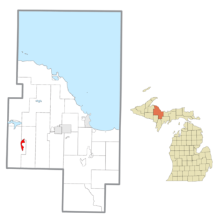
Republic is an unincorporated community in Marquette County in the U.S. state of Michigan. It is also a census-designated place (CDP) for statistical purposes and no legal status as an incorporated municipality. The CDP had a population of 470 at the 2020 census, down from 570 in 2010. The community is located mostly within Republic Township with a small portion extending north into Humboldt Township.

<span class="mw-page-title-main">Canadian Lakes, Michigan</span> Census-designated place in Michigan, United States

Canadian Lakes is an unincorporated community and census-designated place (CDP) in Mecosta County in the U.S. state of Michigan. The area is mostly within the southwest portion of Morton Township, southwest of Mecosta and east of Stanwood. As of the 2020 census, the CDP population was 3,202, up from 2,756 in 2010. The area defined by the CDP includes small portions in eastern Austin Township.

Dalton Township is a civil township of Muskegon County in the U.S. state of Michigan. As of the 2000 census, the township population was 8,047.

Holton Township is a civil township of Muskegon County in the U.S. state of Michigan. As of the 2000 census, the township population was 2,532.

<span class="mw-page-title-main">Montague, Michigan</span> City in Michigan, United States

Montague is a city in Muskegon County in the U.S. state of Michigan. The population was 2,417 at the 2020 census. The city is politically independent from Montague Township, which borders it on three sides.

<span class="mw-page-title-main">Wolf Lake, Michigan</span> Census-designated place in Michigan, United States

Wolf Lake is an unincorporated community and census-designated place (CDP) in Muskegon County in the U.S. state of Michigan. At the 2020 census, the population of Wolf Lake was 5,034, up from 4,104 in 2010. As an unincorporated community, Wolf Lake is governed by Egelston Township.

Claybanks Township is a civil township of Oceana County in the U.S. state of Michigan. The population was 855 at the 2020 census.

<span class="mw-page-title-main">Golden Township, Michigan</span> Township in Michigan, United States

Golden Township is a civil township of Oceana County in the U.S. state of Michigan. The population was 1,660 at the 2020 census. The township is home to the Silver Lake Sand Dunes, and is located along the shore of Lake Michigan.

<span class="mw-page-title-main">Allendale, Michigan</span> Census-designated place & unincorporated community in Michigan, United States

Allendale is a census-designated place (CDP) in Ottawa County in the U.S. state of Michigan. The population was 17,579 at the 2010 census. It is located within Allendale Charter Township, occupying approximately the northern two-thirds of the township, from the eastern boundary with the Grand River west along Pierce St., north along 75th Ave., then west along Lake Michigan Drive (M-45) to the western boundary of the township. It is a part of the Grand Rapids-Muskegon-Holland, Michigan combined statistical area, and is an exurb of Grand Rapids, due to its major commuter routes into the city.

Port Sheldon Township is a civil township of Ottawa County in the U.S. state of Michigan. As of the 2020 census, the township population was 5,206.

<span class="mw-page-title-main">Carrollton Township, Michigan</span> Civil township in Michigan, United States

Carrollton Township is a civil township of Saginaw County in the U.S. state of Michigan. The population was 6,103 at the 2010 census. Established in 1866, Carrollton contains a full-time police department, fire department, parks and recreation services, as well as its own public school system, Carrollton Public Schools. Along with being located on the Saginaw River, Carrollton offers close access to shopping malls, medical facilities, Saginaw Valley State University, and I-75.

Crockery Township is a civil township of Ottawa County in the U.S. state of Michigan. As of the 2010 census, the township population was 3,960.

Maple Valley Township is a civil township of Montcalm County in the U.S. state of Michigan. The population was 1,908 at the 2020 census.

References

43°21′46″N86°09′53″W / 43.36278°N 86.16472°W / 43.36278; -86.16472