
Fowey is a small town, civil parish and cargo port at the mouth of the River Fowey in south Cornwall, England, United Kingdom. The town has been in existence since well before the Norman invasion, with the local church first established some time in the 7th century; the estuary of the River Fowey forms a natural harbour which enabled the town to become an important trading centre. Privateers also made use of the sheltered harbourage. The Lostwithiel and Fowey Railway brought China clay here for export.

St Austell is a town in Cornwall, England, UK, 10 miles (16 km) south of Bodmin and 30 miles (48 km) west of the border with Devon.

The River Fal flows through Cornwall, England, rising at Pentevale on Goss Moor and reaching the English Channel at Falmouth. On or near the banks of the Fal are the castles of Pendennis and St Mawes as well as Trelissick Garden. The River Fal separates the Roseland peninsula from the rest of Cornwall. Like most of its kind on the south coast of Cornwall and Devon, the Fal estuary is a classic ria, or drowned river valley. The Fal estuary from Tregony to the Truro River was originally called Hafaraell.

Cookridge is a suburb of north-west Leeds, West Yorkshire, England, north of the Leeds Outer Ring Road. In 1715 Ralph Thoresby described it as a village four miles from Leeds and three from Otley, dating from 1540.

Tywardreath is a small hilltop village on the south coast of Cornwall, England, United Kingdom. about 3 miles (5 km) north west of Fowey. It is located in a sheltered spot overlooking a silted up estuary opposite Par and near the beach of Par Sands. It is on the Saints' Way path.

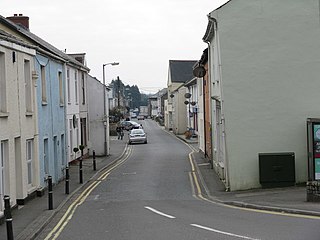
Par is a village and fishing port with a harbour on the south coast of Cornwall, England, United Kingdom. The village is situated in the civil parish of Tywardreath and Par, although West Par and the docks lie in the parish of St Blaise.

Above Derwent is a civil parish in the Borough of Allerdale in Cumbria, England. It lies entirely within the Lake District National Park.

Lakes is a large civil parish in the South Lakeland district of Cumbria, England, with a population of 5,127 according to the 2001 census, decreasing to 4,420 at the 2011 Census. It covers the small town of Ambleside, and the villages and hamlets of Clappersgate, Rydal, Grasmere, Troutbeck, Chapel Stile, Elterwater, Little Langdale and Waterhead.
St Blazey is a small town in Cornwall, England, United Kingdom.
Itchen Valley is a civil parish in the English county of Hampshire. Forming part of the City of Winchester district, it comprises the villages of Avington, Easton, Itchen Abbas and Martyr Worthy, with a population of 1,267 at the time of the 2001 Census. increasing at the 2011 Census to a population of 1,459.

Crawley is a small village in Hampshire, England. It is a few miles from the county town of Winchester. It is a civil parish within the City of Winchester local government district. The village is the location of Crawley Court, currently the headquarters of broadcast infrastructure company Arqiva.

Curdridge is a village and civil parish within the City of Winchester district of Hampshire, England. The parish also contains the similarly-named village of Curbridge. The village has a small school. The parish is located eight miles to the east of Southampton and had a population of 1,292 people in 473 households in the 2001 census, the population increasing to 1,398 in 520 households at the 2011 Census. Curdridge is also known for its annual Curdridge Country Show that takes place in a field off Reading Room Lane

Wonston is a village and civil parish in the City of Winchester district of Hampshire, England. The village had an estimated population of 1,283 in the census of 2001. The civil parish includes the settlements of Sutton Scotney, Stoke Charity, Norton and Hunton. Located in the Hundred of Buddlesgate, the Manor of Wonston is listed in the Domesday Book as belonging to the Bishop of Winchester. The northern boundary of the Civil Parish is marked by the southern boundary of Freefolk Wood.

Whittlesea Mere was an area of open water in the Fenland area of the county of Huntingdonshire, England. The mere occupied the land southeast of Yaxley Fen, south of Farcet Fen and north of Holme Fen. The town of Whittlesey lay to the northeast.
Myrella Cohen FRSA LLD (Hon) was one of the first female judges in Great Britain. She was born into a Jewish family in Manchester in 1927. Her parents, Sam and Sarah Cohen, wanted to name her after their mothers, who were called Myra and Ella, so they came up with the combination of Myrella. She was educated at Manchester High School for Girls and Colwyn Bay Grammar School and then read law at Manchester University. She married Lt. Col. Mordaunt Cohen MBE TD DL, a decorated Burma veteran, whose surname was the same as her own.

Polmear is a hamlet in Cornwall, England, UK. It is located on the A3082 road close to Par Sands and the village of Par. Part is in the civil parish of Fowey and part in Par and Tywardreath parish. The centre of Fowey is some 3 miles (4.8 km) distant, whilst Par railway station is less than 1 mile (1.6 km) away. Polmear used to be known as East Polmear and West Polmear is now known as Charlestown, and has been since Charles Rashleigh built the harbour there.

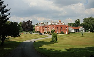
Tythrop Park, also known as Tythrop House, is a Grade I–listed 17th-century manor house, set in 51 acres (21 ha) of parkland, located in Kingsey, Buckinghamshire, England. According to Pevsner the exterior is plain and unpromising, but inside the house he describes the staircase as one of the finest in the county, with "extremely luscious openwork foliage".

Waltham Abbey is a civil parish in Epping Forest District in Essex, England. Located approximately 14 miles (23 km) north-northeast of central London and adjacent to the Greater London boundary, it is a partly urbanised parish with large sections of open land in the Metropolitan Green Belt. Waltham Abbey is a recent renaming of the ancient parish of Waltham Holy Cross. Aside from the town of Waltham Abbey, it includes the hamlets of Claverhambury, Fishers Green, Holyfield, Sewardstone and Upshire, and the village of High Beach. The local council is Waltham Abbey Town Council.

