U.S. Route 190 Business (Covington, Louisiana)

Last updated

Business plate.svg

US 190.svg

U.S. Highway 190 Business

US 190 Business (Covington) map.svg
Route information
Maintained by Louisiana DOTD
Length3.31 mi (5.33 km)
Existed1969–present
Major junctions
West endUS 190.svg US 190 in Covington
East endUS 190.svg US 190 in Covington
Location
Country United States
State Louisiana
Parishes St. Tammany
Highway system
  • Louisiana State Highway System
US 190.svg US 190 Louisiana 191 (2008).svg LA 191

U.S. Highway 190 Business (internally known as U.S. Highway 190-X [1] ) is a 3.31 mile (5.88 km) business route of US 190 in Covington, Louisiana. [2] [3] It is known locally as 21st Avenue and Boston Street. The route is primarily used to access southbound Louisiana Highway 21 (LA 21) and Covington's business district. It also is Covington's road grid divider between north and south for a part of its length.

Contents

Route description

From the west, US 190 Business begins at an intersection with US 190 to the west of Covington. It continues through Covington's downtown business district as 21st Avenue, where it intersects LA 21 (South Tyler Street). LA 21 turns onto 21st Avenue and begins its concurrency with US 190 Business. Crossing Theard Street, the road becomes known as Boston Street. US 190 Business continues until it reaches US 190, where a southbound exit ramp to US 190 is present. At the same intersection is where LA 21 continues eastward, while US 190 makes a right turn onto a small road that parallels US 190. Continuing south (but signed as east), US 190 Business intersects US 190 about a quarter of a mile later. At the eastern terminus of US 190 Business, signs guide drivers to I-12 and the cities of Mandeville and New Orleans via southbound US 190. [2]

Business US 190 is an undivided, two-lane highway for its entire length.

History

The creation of US 190 Business stems from the building of the bypass around Covington. The first half of the bypass, which ran north to south, was constructed in the mid-to-late 1950's to move Louisiana Highway 25 out of downtown Covington. This part of the Covington bypass was opened to traffic in 1958. [4] The second half of the bypass, which runs west to east, was opened in 1969. The Louisiana Department of Highways petitioned the American Association of State Highway Officials (AASHO) to move US 190 to the new bypass while making the former alignment a business route. Both requests were approved at the AASHO meeting in June 1969 and the Louisiana Department of Highways began signposting the routes as such the same year. [5] The LA 25 designation was truncated to its intersection at the north end of the new bypass at this time as well.

Junction list

The entire highway is in Covington, St. Tammany Parish.

mi [6] kmDestinationsNotes
0.000.00US 190.svg US 190
1.712.75South plate.svg
Louisiana 21 (2008).svg
To plate blue.svg
I-12.svg
LA 21 south (S. Tyler Street) to I-12
West end of LA 21 overlap
3.004.83South plate.svg
US 190.svg
North plate.svg
Louisiana 21 (2008).svg
US 190 south / LA 21 north
East end of LA 21 overlap; southbound exit to US 190
3.315.33US 190.svgTo plate blue.svg
I-12.svg
US 190 to I-12  Mandeville, New Orleans
1.000 mi = 1.609 km; 1.000 km = 0.621 mi

Related Research Articles

<span class="mw-page-title-main">Interstate 12</span> Interstate in Louisiana

Interstate 12 (I-12) is an intrastate Interstate Highway located entirely within the US state of Louisiana. It spans a total of 85.59 miles (137.74 km) in an east–west direction from I-10 in Baton Rouge to an interchange with both I-10 and I-59 in Slidell. Along the way, it passes through the city of Hammond, where it intersects I-55 and US Route 51 (US 51). It also serves the cities of Ponchatoula and Denham Springs, as well as the St. Tammany Parish cities of Covington and Mandeville.

<span class="mw-page-title-main">U.S. Route 190</span> Highway in the United States

U.S. Route 190 (US 190) is an east–west United States Highway in Louisiana and Texas. Segments of US 190 will be upgraded to Interstate 14 (I-14); the first 24.8-mile (39.9 km) segment was opened on January 26, 2017.

<span class="mw-page-title-main">U.S. Route 167</span> Highway in the United States

U.S. Route 167 is a north-south United States Highway within the U.S. states of Louisiana and Arkansas. It runs for 500 miles (800 km) from Ash Flat, Arkansas at U.S. Route 62/U.S. Route 412 to Abbeville, Louisiana at Louisiana Highway 14. It goes through the cities of Little Rock, Arkansas, Alexandria, Louisiana, and Lafayette, Louisiana.

<span class="mw-page-title-main">U.S. Route 90 in Louisiana</span> Highway in Louisiana

U.S. Highway 90 (US 90), one of the major east–west U.S. Highways in the Southern United States, runs through southern Louisiana for 297.6 miles (478.9 km), serving Lake Charles, Lafayette, New Iberia, Morgan City, and New Orleans. Much of it west of Lafayette and east of New Orleans has been supplanted by Interstate 10 (I-10) for all but local traffic, but the section between Lafayette and New Orleans runs a good deal south of I-10.

<span class="mw-page-title-main">Louisiana Highway 21</span> State highway in Louisiana, United States

Louisiana Highway 21 is a state highway in Louisiana that serves St. Tammany and Washington Parishes. It spans 51.76 miles (83.30 km) and is signed north and south.

<span class="mw-page-title-main">Louisiana Highway 13</span> State highway in Louisiana, United States

Louisiana Highway 13 (LA 13) is a state highway located in southern Louisiana. It runs 64.02 miles (103.03 km) in a north–south direction from LA 14 west of Kaplan to US 167 in Turkey Creek.

<span class="mw-page-title-main">Louisiana Highway 22</span> State highway in Louisiana, United States

Louisiana Highway 22 (LA 22) is a state highway located in southeastern Louisiana. It runs 71.15 miles (114.50 km) in a general east–west direction from the junction of LA 75 and LA 942 in Darrow to U.S. Highway 190 (US 190) in Mandeville.

<span class="mw-page-title-main">Louisiana Highway 25</span> State highway in Louisiana, United States

Louisiana Highway 25 (LA 25) is a state highway located in southeastern Louisiana. It runs 38.72 miles (62.31 km) in a north–south direction from U.S. Highway 190 (US 190) in Covington to the Mississippi state line north of Warnerton.

<span class="mw-page-title-main">Louisiana Highway 59</span> State highway in Louisiana, United States

Louisiana Highway 59 (LA 59) is a state highway located in St. Tammany Parish, Louisiana. It runs 11.74 miles (18.89 km) in a north–south direction from U.S. Highway 190 (US 190) in Mandeville to LA 21 north of Abita Springs.

<span class="mw-page-title-main">Louisiana Highway 182</span> Highway in Louisiana

Louisiana Highway 182 (LA 182) is a state highway located in central and southeastern Louisiana. It runs 173.41 miles (279.08 km) in a northwest to southeast direction from LA 29 in Whiteville to U.S. Highway 90 (US 90) north of Raceland.

<span class="mw-page-title-main">U.S. Route 11 in Louisiana</span> Segment of American highway

U.S. Highway 11 (US 11) is a part of the United States Numbered Highway System that spans 1,645 miles (2,647 km) from New Orleans, Louisiana, to Rouses Point, New York. Within the state of Louisiana, the highway travels 31 miles (50 km) from the national southern terminus at US 90 in New Orleans to the Mississippi state line south of Picayune.

<span class="mw-page-title-main">Special routes of U.S. Route 61</span> Highway system

Several special routes of U.S. Route 61 exist in the states of Louisiana, Mississippi, Missouri, and Iowa.

<span class="mw-page-title-main">Louisiana Highway 36</span> State highway in Louisiana, United States

Louisiana Highway 36 is a state highway in Louisiana that serves St. Tammany Parish. It spans 19.0 miles (30.6 km) and is bannered east/west.

<span class="mw-page-title-main">Louisiana Highway 41</span> State highway in Louisiana, United States

Louisiana Highway 41 (LA 41) is a state highway located in St. Tammany Parish, Louisiana. It runs 23.07 miles (37.13 km) in a north–south direction from the junction of U.S. Highway 11 (US 11) and LA 3081 in Pearl River to LA 21 in Bush.

<span class="mw-page-title-main">U.S. Route 61/190 Business</span> Business route in Louisiana, United States

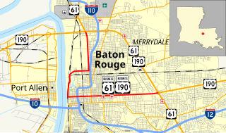
U.S. Highway 61/190 Business is a business route of both U.S. Route 61 and U.S. Route 190 in Louisiana that serves as a boulevard into downtown Baton Rouge. It spans 10.89 miles (17.53 km) in a southeast to northwest direction and it is signposted as Business 61/190, generally without directional shields. It follows parts of the former alignment of US 61/190 through Baton Rouge, which existed in downtown Baton Rouge from 1935 until 1960.

<span class="mw-page-title-main">Louisiana Highway 3114</span> State highway in Louisiana, United States

Louisiana Highway 3114 was a state highway in Louisiana that served St. Tammany Parish. It spanned a total of 1.7 miles (2.7 km) along the present route of U.S. 190 on the north side of Covington.

References

Template:Attached KML/U.S. Route 190 Business (Covington, Louisiana)
KML is from Wikidata
  1. "Louisiana State Highway Log". AARoads. Retrieved 2020-12-20.
  2. 1 2 Google (8 December 2020). "U.S. Route 190 Business (Covington, Louisiana)" (Map). Google Maps . Google. Retrieved 8 December 2020.
  3. Louisiana Department of Transportation and Development. "LADOTD Functional System Map". ladotd.maps.arcgis.com. Retrieved 2020-12-20.
  4. "BridgeReports.com | US0190 over US 190 OVER US 190B, St. Tammany Parish, Louisiana". bridgereports.com. Retrieved 2020-12-20.
  5. "An Application from the State Highway Department of Louisiana for the Relocation of U.S. Route 190". 1969. Retrieved December 20, 2020.
  6. Google (8 December 2020). "U.S. Route 190 Business (Covington, Louisiana)" (Map). Google Maps . Google. Retrieved 8 December 2020.