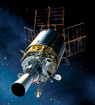
The Defense Support Program (DSP) is a program of the United States Space Force that operated the reconnaissance satellites which form the principal component of the Satellite Early Warning System used by the United States.

The Space-Based Infrared System (SBIRS) is a United States Space Force system intended to meet the United States' Department of Defense infrared space surveillance needs through the first two to three decades of the 21st century. The SBIRS program is designed to provide key capabilities in the areas of missile warning, missile defense, battlespace characterization and technical intelligence via satellites in geosynchronous Earth orbit (GEO), sensors hosted on satellites in highly elliptical orbit (HEO), and ground-based data processing and control.
Lockheed Martin Space is one of the four major business divisions of Lockheed Martin. It has its headquarters in Littleton, Colorado, with additional sites in Valley Forge, Pennsylvania; Sunnyvale, California; Santa Cruz, California; Huntsville, Alabama; and elsewhere in the United States and United Kingdom. The division currently employs about 20,000 people, and its most notable products are commercial and military satellites, space probes, missile defense systems, NASA's Orion spacecraft, and the Space Shuttle external tank.

Fēngyún are China's meteorological satellites. Launched since 1988 into polar Sun-synchronous and geosynchronous orbit, each three-axis stabilized Fengyun satellite is built by the Shanghai Academy of Spaceflight Technology (SAST) and operated by the China Meteorological Administration (CMA). To date, China has launched twenty-one Fengyun satellites in four classes. Fengyun 1 and Fengyun 3 satellites are in polar, Sun-synchronous orbit and Low Earth orbit while Fengyun 2 and 4 are geosynchronous orbit.

United Launch Alliance, LLC (ULA) is an American launch service provider formed in December 2006 as a joint venture between Lockheed Martin Space and Boeing Defense, Space & Security. The company designs, assembles, sells and launches rockets, but the company subcontracts out the production of rocket engines and solid rocket boosters.

USA-200, also known as NRO Launch 28 or NROL-28, is an American signals intelligence satellite, operated by the National Reconnaissance Office. Launched in 2008, it has been identified as the second satellite in a series known as Improved Trumpet, Advanced Trumpet, or Trumpet follow-on; a replacement for the earlier Trumpet series of satellites.
The Space Tracking and Surveillance System was a pair of satellites developed by the United States Missile Defense Agency (MDA) to research the space-based detection and tracking of ballistic missiles. Data from STSS satellites could allow interceptors to engage incoming missiles earlier in flight than would be possible with other missile detection systems. The STSS program began in 2001, when the "SBIRS Low" program was transferred to MDA from the United States Air Force. In December 2002, SBIRS Low Research & Development was renamed Space Tracking and Surveillance System (STSS).
USA-205, also known as Space Tracking and Surveillance System-Advanced Technology Risk Reduction (STSS-ATRR), and previously as Block 2010 Spacecraft Risk Reduction is a satellite formerly operated by the United States Missile Defense Agency. It was launched to demonstrate new technology for missile detection early warning systems (MDEWS). The technology demonstrated on STSS-ATRR was used in the development of the Space Tracking and Surveillance System (STSS) part of the Space-Based Infrared System (SBIRS).

The Joint Tactical Ground Station (JTAGS) is the United States Space Force's element to United States Strategic Command's Theater Event System (TES). TES provides an integrated, in-theater, 24-hour overhead non-imaging infrared detection capability for processing and disseminating missile early warning, alerting, and cueing information data to combatant commanders and missile defense assets through the use of stereo processing of the Defense Support Program (DSP) satellite data.
USA-230, also known as SBIRS GEO-1, is a United States military satellite and part of the Space-Based Infrared System.

USA-241, also known as SBIRS GEO-2, is a United States military satellite and part of the Space-Based Infrared System.
An early warning satellite is a satellite designed to rapidly detect ballistic missile launches and thus enable defensive military action. To do this, these satellites use infrared detectors that identify the missile thanks to the heat given off by its engines during the propulsion phase.

USA-273, also known as SBIRS GEO-3, is a United States military satellite and part of the Space-Based Infrared System (SBIRS).
USA-282, also known as SBIRS GEO-4, is a United States military satellite and part of the Space-Based Infrared System.

The Joint Overhead Persistent Infrared Center (JOPC) is a subordinate center of United States Space Command's Combined Force Space Component Command. It is responsible for planning and coordinating overhead persistent infra-red operations. The JOPC is located at Buckley Space Force Base.

USA-298, also known as Advanced Extremely High Frequency 6 or AEHF-6, is a military communications satellite operated by the United States Space Force (USSF). It is the sixth of six satellite to be launched as part of the Advanced Extremely High Frequency program, which replaced the earlier Milstar system.
Tongxin Jishu Shiyan is a Chinese military satellite program operating in geostationary orbit (GEO). TJS satellites are manufactured by the Shanghai Academy of Spaceflight Technology (SAST) and launched from Xichang Satellite Launch Center (XSLC) in China's southern Sichuan Province. TJS is likely the cover name for multiple geostationary military satellite programs and should not be confused with the similarly named Shiyan satellite program.
USA-315, also known as SBIRS GEO-5, is a military satellite developed as a part of the Space-Based Infrared System. The satellite aims to increase the capabilities of the United States Department of Defense in terms of missile defense and military intelligence.
