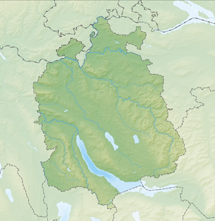
The Albis is a chain of hills in the Canton of Zürich, Switzerland, stretching for some 19 km from Sihlbrugg in the south to Waldegg near Zürich in the north. The chain forms, among others, the border between the Affoltern and Horgen districts. The best known point is Uetliberg at 870 m, overlooking the city of Zürich. Other points of interest include the Albishorn (909m.) the Bürglen, the Schnabelburg, an observation tower, the Albis Pass, the small town of Buechenegg, and the extensive woods on both sides of the river Sihl. The Sihl Valley borders the Albis chain on its entire east side. On the west side, the Albis is bordered by various streams and one lake, the Türlersee.

Albis Pass is a mountain pass in the Albis range in the canton of Zurich in Switzerland. It connects Langnau am Albis with the small village of Türlen on the Türlersee and, further on, Aeugst am Albis, Hausen am Albis, Mettmenstetten and Rifferswil. Other nearby passes across the same chain are Buechenegg to the north, and Schnabellücken, which is undeveloped except for a hiking trail, to the south. The eastern ramp and crest of the pass is in the municipality of Langnau, with the western ramp in Hausen.

Adliswil is a town and a municipality in the district of Horgen in the canton of Zürich in Switzerland.
Buechenegg Pass is a mountain pass in the Albis range in the canton of Zurich in Switzerland. It connects Langnau am Albis and Tägerst, on the road from Aeugst am Albis to Stallikon. The western ramp and crest of the pass is in the municipality of Stallikon, with the eastern ramp in Langnau. A walking trail follows the ridge-line of the Albis range and connects Buechenegg with Felsenegg and Uetliberg, to the north, and the Albis Pass to the south.
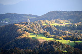
Felsenegg is a vantage point in the canton of Zürich in Switzerland.

The Sihltal Zürich Uetliberg Bahn AG – commonly abbreviated to SZU – is a railway company and transport network in the canton of Zürich in Switzerland. The network comprises the Uetliberg railway line and the Sihltal railway line, a cable car and a network of bus services.

Zimmerberg is a mountain and a region located in the district of Horgen in the canton of Zurich, Switzerland. Its name bases on the Old High German word zimbar in the meaning of lumber.

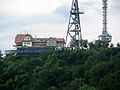
The Adliswil-Felsenegg cable car is a cable car in the canton of Zürich in Switzerland. The lower station is located in Adliswil in the Sihl Valley, whilst the upper station is located on the Felsenegg hill on the Albis ridge near the Felsenegg-Girstel TV-tower. The upper station at Felsenegg forms one end of a panoramic walk to the Uetliberg mountain, whilst the lower station is some 400 metres (1,300 ft) from Adliswil railway station.

Pfannenstiel is a wooded mountain respectively a region overlooking the Lake Zürich and Zürcher Oberland in the canton of Zürich in Switzerland.

Sihl Valley is a river valley and belongs to the Zimmerberg-Sihltal region located in the district of Horgen in the canton of Zurich, Switzerland. Commonly Sihltal is used as the name of the Lower Sihl Valley, i.e. the area in the southwest of the city of Zürich.
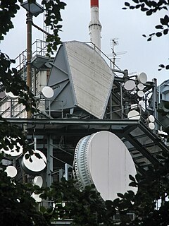
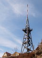
The Felsenegg Tower is a broadcasting tower located nearby Felseneggbahn mountain station on the Felsenegg vantage point in the canton of Zürich in Switzerland. The tower is owned by Swisscom Broadcast AG and generally not accessible by the public.
Zürich Selnau,, is an underground railway station on the Zürich S-Bahn system in Selnau in the centre of the Swiss city of Zürich. The station is on a section of tunnel common to the Uetliberg line and the Sihltal line, both of which are operated by the Sihltal Zürich Uetliberg Bahn (SZU).

Uetliberg is a railway station in Switzerland, situated near to the summit of the Uetliberg mountain. The station is the terminus of the Uetliberg line, which is operated by the Sihltal Zürich Uetliberg Bahn (SZU). It is located within the municipality of Stallikon, although the adjacent mountain-top is divided between Stallikon and the city of Zürich.
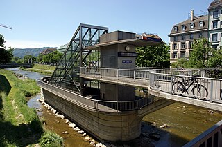
Adliswil is a railway station in the Sihl Valley, and the municipality of Adliswil, in the Swiss Canton of Zürich. The station is on the Sihltal line, which is operated by the Sihltal Zürich Uetliberg Bahn (SZU).

The Sihltal railway line is a railway line in the Swiss canton of Zürich, which connects the city of Zürich with the communities of the Sihl Valley. Passenger service on the line now forms part of the Zürich S-Bahn, branded as that network's service S4, and is part of the Zürcher Verkehrsverbund (ZVV) zone-based fare network.

The Uetliberg railway line is a passenger railway line which runs from the central station in the Swiss city of Zürich through the city's western outskirts to the summit of the Uetliberg. The route serves as line S10 of the Zürich S-Bahn, with the Zürcher Verkehrsverbund's (ZVV's) standards zonal fares applying.

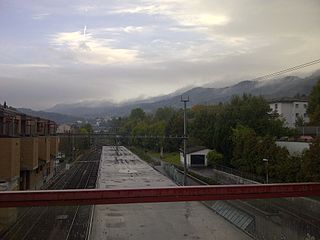
Langnau-Gattikon is a railway station in the Sihl Valley, and the municipality of Langnau am Albis, in the Swiss Canton of Zürich. Gattikon is an adjacent settlement, part of the municipality of Thalwil. The station is on the Sihltal line, which is operated by the Sihltal Zürich Uetliberg Bahn (SZU).
Wildpark-Höfli is a railway station in the Sihl Valley, and the municipality of Langnau am Albis, in the Swiss Canton of Zurich. The station is on the Sihltal line, which is operated by the Sihltal Zürich Uetliberg Bahn (SZU). It takes its name from the nearby settlement of Höfli, and the Wildpark Langenberg, a nearby zoo.
Baldern Castle is a former castle in the municipality of Stallikon and the canton of Zürich in Switzerland. The remains of the castle comprise a set of earthworks, situated on the Albis ridge at some 810 metres (2,660 ft) above sea level and about 4 kilometres (2.5 mi) south of the summit of Uetliberg. The earthworks are obscured by the site's woodland nature.

Zürich HB SZU railway station is a railway station in the municipality of Zürich, in the Swiss canton of Zürich. It is underneath and physically connected to the Zürich Hauptbahnhof, Zürich's primary train station, although they do not share any tracks. The station is the terminus of the standard gauge Sihltal and Uetliberg railway lines of the Sihltal Zürich Uetliberg Bahn. The station opened on 5 May 1990, following the completion of a new tunnel under the Sihl from the old terminus at Zürich Selnau.