Monroe is a town located in eastern Fairfield County, Connecticut, United States. The population was 18,825 at the 2020 census. The town is part of the Greater Bridgeport Planning Region.

Trumbull is a town located in Fairfield County, Connecticut, United States. The town is part of the Greater Bridgeport Planning Region, and borders on the cities of Bridgeport and Shelton, as well as the towns of Stratford, Fairfield, Easton and Monroe. The population was 36,827 during the 2020 census. Trumbull was the home of the Golden Hill Paugussett Indian Nation for thousands of years before the English settlement was made in 1639. The town was named after Jonathan Trumbull (1710–1785), a merchant, patriot and statesman, at its incorporation in 1797. Aviation pioneer Igor Sikorsky lived in Trumbull during his active years when he designed, built, and flew fixed-wing aircraft and put the helicopter into mass production for the first time.
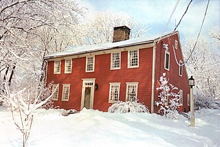
The Ephraim Hawley House is a privately owned Colonial American wooden post-and-beam timber-frame saltbox house situated on the Farm Highway, Route 108, on the south side of Mischa Hill, in Nichols, a village located within the town of Trumbull, Connecticut, the U.S. It was expanded to its present shape by three additions. Over time the house has been classified as located in four different named townships, as jurisdictional boundaries changed, but it has never been moved. These towns were Stratford (1670–1725), Unity (1725–1744), North Stratford (1744–1797), and Trumbull (1797–present).
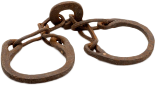
Nero Hawley was an African-American soldier who was born into slavery in North Stratford, Connecticut, and later earned his freedom after enlisting in the Continental Army in place of his owner, Daniel Hawley, on April 20, 1777, during the American Revolution. His life is featured in the 1976 book From Valley Forge to Freedom, which also notes other areas of present-day Trumbull, Connecticut associated with Hawley.
David Hawley (1741–1807) was a captain in the Continental Navy and a privateer during the American Revolutionary War. He commanded Royal Savage in the 1776 Battle of Valcour Island, which is generally regarded as one of the first naval battles of the American Revolutionary War, and one of the first fought by the United States Navy.
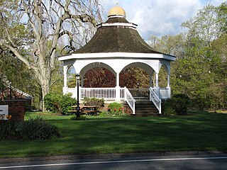
Nichols, a historic village in southeastern Trumbull in Fairfield County, Connecticut, is named after the family who maintained a large farm in its center for almost 300 years. The Nichols Farms Historic District, which encompasses part of the village, is listed on the National Register of Historic Places. Originally home to the Golden Hill Paugussett Indian Nation, the area was colonized by the English during the Great Migration of the 1630s as a part of the coastal settlement of Stratford. The construction of the Merritt Parkway through the village, and the subsequent closing of stores and factories, turned the village into a bedroom community in 1939. Aviation pioneer Igor Sikorsky lived in three separate homes in Nichols during his active years between 1928 and 1951, when he designed, built and flew fixed-wing aircraft and put the helicopter into mass production for the first time.

Route 108 in the U.S. state of Connecticut, locally called Nichols Avenue and Huntington Turnpike, is a two-lane state highway that runs northerly from US 1, Boston Post Road in Stratford, through Trumbull, to Route 110 in downtown Shelton. Originally called the Farm Highway, it was laid out to the south side of Mischa Hill in Trumbull on December 7, 1696 and is considered to be the third oldest documented highway in Connecticut after the Mohegan Road in Norwich (1670) and the Boston Post Road or US 1 (1673).

Robert Hawley (1729–1799), Captain, raised provisions for the Continental Army soldiers and fought in the American Revolutionary War.
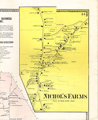
Nichols Farms is a historic area within the town of Trumbull, Connecticut. The Nichols Farms Historic District, which encompasses part of the area, is listed on the National Register of Historic Places.

Gregory's Four Corners Burial Ground, a cemetery established in Trumbull, Connecticut in 1761, is located on Spring Hill Road near the Monroe town line and is maintained by the Trumbull Parks Commission.
Joseph Hawley (1603–1690), may have been born in Parwich, Derbyshire, England, was the first of the Hawley name to come to America in 1629. He settled at Stratford, Connecticut, by 1650, becoming the town's first town clerk or record keeper, tavern (ordinary) keeper and a shipbuilder.

Route 127 is a state highway in southwestern Connecticut, running entirely from Bridgeport to Trumbull. It serves as a minor arterial, connecting all four major freeways in the Bridgeport area.

Trumbull, a town in Fairfield County, Connecticut, in the New England region of the United States, was originally home to the Golden Hill Paugussett Indian Nation, and was colonized by the English during the Great Migration of the 1630s as a part of the coastal settlement of Stratford.
A Great Jubilee Day, first held on Monday May 26, 1783, in North Stratford, now Trumbull, Connecticut, commemorated the end of fighting in the American Revolutionary War. This celebration included feasting, prayer, speeches, toasts, and two companies of the North Stratford militia performing maneuvers with cannon discharges and was one of the first documented celebrations following the War for Independence and continued as Decoration Day and today as Memorial Day with prayer services and a parade.

The Pequonnock River is a 16.7-mile-long (26.9 km) waterway in eastern Fairfield County, Connecticut. Its watershed is located in five communities, with the majority of it located within Monroe, Trumbull, and Bridgeport. The river has a penchant for flooding, particularly in spring since the removal of a retention dam in Trumbull in the 1950s. There seems to be a sharp difference of opinion among historians as to just what the Indian word Pequonnock signifies. Some insist it meant cleared field or open ground; others are sure it meant broken ground; while a third group is certain it meant place of slaughter or place of destruction.

Long Hill is a neighborhood and census-designated place (CDP) in the town of Trumbull in Fairfield County, Connecticut, United States. It is located west of the Pequonnock River. The main thoroughfare is Connecticut Route 111, present-day Main Street. It was listed as a census-designated place prior to the 2020 census.

St. Catherine of Siena is a Roman Catholic parish in Trumbull, Connecticut, part of the Diocese of Bridgeport.

The Zachariah Curtiss House is located at 2950 Nichols Avenue on the east side of the Farm Highway or Route 108 on the south side of Mischa Hill, in the village of Nichols in Trumbull, Connecticut in New England. The house was built by Zachariah II between 1721 and 1746 in the Georgian architectural style. The Colonial American wooden post-and-beam timber frame farm house has a one and one-half story ell added in 1800. The house has the distinction of being located in four different townships in its history, but has never been moved; Stratford (1686–1725), Unity (1725–1744), North Stratford (1744–1797) and Trumbull (1797-present). It is currently in a dilapidated state awaiting demolition.
Lieut. Joseph Judson was an early New England colonist best known for co-founding the town of Woodbury, Connecticut.
James Beebe (1717–1785), Reverend, presided over the Unity Parish at North Stratford, now Trumbull, Connecticut, between 1747 and 1785. He was an Army Preacher in the French and Indian War and a patriot.

