Urban areas in the Nordic countries

Last updated

An urban area in the Nordic countries , with the exception of Iceland, is defined as a distinct statistical concept used to differentiate population clusters independent of municipal borders. The population is measured on a national level, independently by each country's statistical bureau. Statistics Sweden uses the term tätort (urban settlement), Statistics Finland also uses tätort in Swedish and taajama in Finnish, Statistics Denmark uses byområde (city), while Statistics Norway uses tettsted (urban settlement).

Contents

A uniform statistical definition between the Nordic countries was agreed upon in 1960, [1] which defines an urban area as a continuous built-up area whose population is at least 200 inhabitants and where the maximum distance between residences is 200 metres; discounting roads, parking spaces, parks, sports grounds and cemeteries – without regard to the ward, municipal or county boundaries. [1] [2] Despite the uniform definition, the various statistical bureaus have different approaches in conducting these measurements, resulting in slight variation between the different countries. [lower-alpha 1]

Despite belonging to the Nordic countries, Iceland does not follow the same definition of "urban area" for statistical purposes. The Nordic definition is unique to the four other countries, and should not be confused with the international concepts of metropolitan area or urban areas in general.

Urban areas in Sweden

The largest urban area in the Nordic countries surrounds Stockholm.
.mw-parser-output .legend{page-break-inside:avoid;break-inside:avoid-column}.mw-parser-output .legend-color{display:inline-block;min-width:1.25em;height:1.25em;line-height:1.25;margin:1px 0;text-align:center;border:1px solid black;background-color:transparent;color:black}.mw-parser-output .legend-text{}
The Stockholm urban area

Sollentuna and Upplands Vasby

Other smaller urban areas Tatorter Stockholm 2015.png
The largest urban area in the Nordic countries surrounds Stockholm.   The Stockholm urban area
   Sollentuna and Upplands Väsby
  Other smaller urban areas

In Sweden, urban areas are measured by the national statistical institution Statistics Sweden. They utilize the native language term tätort in Swedish and "locality" in English. There are a total 1,979 localities in Sweden, with the largest being the Stockholm urban area at approximately 1,580,000 inhabitants in 2017. [3] Roughly 87% of the Swedish population lives within localities. [3]

Statistics Sweden also utilizes småort "smaller locality" to refer to a rural locality with 50–199 inhabitants in a contiguous built-up area with no more than 150 meters between houses. The concept is rarely used outside the field of statistics, where it is used for settlements just below the limit defined for tätort. [4]

Urban areas in Denmark

Urban areas in Finland

An example of Finnish urban area borders, defined along a 250 m (820 ft) by 250 m (820 ft) grid Nummen kk and Saukkola urban areas (taajamat) by Statistics Finland (Tilastokeskus).png
An example of Finnish urban area borders, defined along a 250 m (820 ft) by 250 m (820 ft) grid

In Finland, urban areas are measured by the national statistical institution Statistics Finland. They utilize the native language terms tätort in Swedish and taajama in Finnish. The largest urban area in Finland is the Helsingin keskustaajama ("Helsinki central urban area") with approximately 1,270,000 inhabitants in 2017. [5] It extends across Helsinki as well as 10 other municipalities in the Greater Helsinki area. The second largest is the Tampereen keskustaajama with approximately 330,000 inhabitants in 2017. [5]

Statistics Finland measures urban areas along a 250 m (820 ft) by 250 m (820 ft) grid, resulting in minor inaccuracies and differences in definition between it and the other Nordic countries. The rough presence of urban areas is used to regulate traffic, with a default of 50 kilometres per hour (31 mph) speed limit inside a taajama and 80 kilometres per hour (50 mph) outside. Most major roads leading in or out of an urban area are marked with a road sign.

Urban areas in Norway

Despite adhering to the same definition of an urban area as the rest of the Nordics, Norway utilizes an automated demarcation system, in use since 1999. The demarcation system has been updated on a few occasions, most recently in 2013. [6] In 2013, there were a total of 963 differentiated urban areas in the country. [6] The largest of these is the urban area surrounding Oslo, with a population of approximately 1 million.

See also

Notes

  1. For example, Statistics Finland utilizes a grid system of 62,500 square metres (15.4 acres) for analyzing population, resulting in slight measurement differences between it and the other Nordic statistical bureaus.

Related Research Articles

<span class="mw-page-title-main">Vantaa</span> City in Uusimaa, Finland

Vantaa is a city and municipality in Finland. It is part of the inner core of the Finnish Capital Region along with Helsinki, Espoo, and Kauniainen. With a population of 243,496, Vantaa is the fourth most populated city in Finland after Helsinki, Espoo and Tampere. Its administrative center is the Tikkurila district. Vantaa is bordered by Helsinki, the Finnish capital, to the south; Espoo to the southwest; Nurmijärvi to the northwest; Kerava and Tuusula to the north; and Sipoo to the east. The city encompasses 240.35 square kilometres (92.80 sq mi), of which 1.97 km2 (0.76 sq mi) is water.

<span class="mw-page-title-main">Nurmijärvi</span> Municipality in Uusimaa, Finland

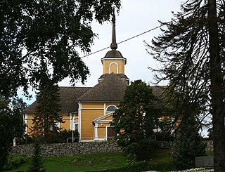
Nurmijärvi is the most populated rural municipality of Finland, located 37 kilometres (23 mi) north of the capital Helsinki. The neighboring municipalities of Nurmijärvi are Espoo, Vantaa, Tuusula, Hyvinkää and Vihti, and it is part of the Greater Helsinki. The population of the municipality is 44,435 inhabitants. In recent decades, it has been one of the fastest growing municipalities in the Greater Helsinki and also in whole Finland in terms of population. The close proximity to Helsinki has led to a considerable growth of the major villages such as Klaukkala, Rajamäki and Röykkä. Klaukkala is the biggest built-up area of Nurmijärvi, which nowadays is considered a dormitory town of Helsinki. The Nurmijärvi church village (Kirkonkylä) is the administrative centre of the municipality, although the clear emphasis on population growth is in Klaukkala.

<span class="mw-page-title-main">Forssa</span> Town in Kanta-Häme, Finland

Forssa is a town and municipality of Finland. It is located almost in the centre of a triangle defined by the three largest major cities in Finland, in the Tavastia Proper region, and which is crossed by Highway 2 between Pori and Helsinki and Highway 10 between Turku and Hämeenlinna. The town has a population of 16,431 and covers an area of 253.38 square kilometres (97.83 sq mi) of which 4.61 km2 (1.78 sq mi) is water. The population density is 66.05 inhabitants per square kilometre (171.1/sq mi). Only a little part of the surface area of Forssa is water, but the river Loimijoki forms an important element in the cityscape, with the city being located at its starting point. Other notable water areas in Forssa include the lake Kaukjärvi and the lake Koijärvi, known as the birthplace of the Green League.

<span class="mw-page-title-main">Urban area</span> Human settlement with high population density and infrastructure of built environment

An urban area, built-up area or urban agglomeration is a human settlement with a high population-density and an infrastructure of built environment.

<span class="mw-page-title-main">Kuusamo</span> Town and municipality in North Ostrobothnia, Finland

Kuusamo is a town and municipality in Finland. It is located in the Northern Ostrobothnia region. The municipality has a population of 15,124 and covers an area of 5,808.92 square kilometres (2,242.84 sq mi) of which 830.81 km2 (320.78 sq mi) is water. The population density is 3.04 inhabitants per square kilometre (7.9/sq mi).

<span class="mw-page-title-main">Kärsämäki</span> Municipality in North Ostrobothnia, Finland

Kärsämäki is a municipality of Finland. It is located in the province of Oulu and is part of the Northern Ostrobothnia region. The municipality has a population of 2,467 and covers an area of 700.91 square kilometres (270.62 sq mi) of which 6.06 km2 (2.34 sq mi) is water. The population density is 3.55 inhabitants per square kilometre (9.2/sq mi). Kärsämäki is a significant road junction where Highway 4 (Helsinki–Oulu–Utsjoki) and Highway 28 (Kokkola–Kajaani) intersect and where Highway 58 leading to Kangasala begins. The distance to the regional capital Oulu is 123 kilometres (76 mi).

<span class="mw-page-title-main">Greater Helsinki</span> Metropolitan area in Uusimaa, Finland

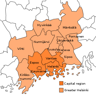
Greater Helsinki is the metropolitan area surrounding Helsinki, the capital city of Finland. It includes the smaller Capital Region urban area.

An urban area or tätort in Sweden has a minimum of 200 inhabitants and may be a city, town or larger village. It is a purely statistical concept, not defined by any municipal or county boundaries. Larger urban areas synonymous with cities or towns for statistical purposes have a minimum of 10,000 inhabitants. The same statistical definition is also used for urban areas in the other Nordic countries.

<span class="mw-page-title-main">City proper</span> Geographical area contained within the defined boundary of a city

A city proper is the geographical area contained within city limits. The term proper is not exclusive to cities; it can describe the geographical area within the boundaries of any given locality. The United Nations defines the term as "the single political jurisdiction which contains the historical city centre."

<span class="mw-page-title-main">Nordic countries</span> Geographical and cultural region

The Nordic countries are a geographical and cultural region in Northern Europe and the North Atlantic. It includes the sovereign states of Denmark, Finland, Iceland, Norway and Sweden; the autonomous territories of the Faroe Islands and Greenland; and the autonomous region of Åland.

<span class="mw-page-title-main">Urban areas in Finland</span>

An urban area in Finland is defined as a cluster of dwellings with at least 200 inhabitants. The Finnish term for this is a taajama. Because of the strict definition of a taajama, these areas exist both inside and outside of city and municipal borders.

<span class="mw-page-title-main">Helsinki urban area</span> Metropolitan area in Finland

The Helsinki urban area, is the largest taajama in Finland. It's located in the Uusimaa region in Finland and has about 1.23 million inhabitants as of 2019.

Tampere urban area, is the largest urban area, taajama in the Pirkanmaa region, and the second largest urban area in whole Finland after the Helsinki urban area. At the end of 2018 it had a population of 337 541 with a land area of 277.54 km2, resulting in a population density of 1 216.2 inhabitants per km2 in the urban area.

References

  1. 1 2 "Nationalencyklopedin - Tätort". Nationalencyklopedin . Retrieved 21 July 2014. Translation: 'a for the Nordic countries shared statistical definition of built-up area with at least 200 residents, not more than 200 m between each other (without regard to the ward, municipal or county boundaries)'
  2. "Localities 2010: Population, age and gender" (PDF) (in Swedish and English). Statistics Sweden . Retrieved 21 July 2014. A densely built area includes any cluster of buildings with at least 200 inhabitants, unless the distance between the houses exceeds 200 metres. However, the distance may exceed 200 metres if the cluster of buildings is situated within the area of influence of a larger locality. [...] Even if the distance between buildings exceeds 200 metres, the locality should not be divided if the area between the buildings is used for public purposes such as roads, parking spaces, parks, sports grounds and cemeteries. The same applies to undeveloped areas such as storage sites, railways and docks
  3. 1 2 "Roughly 87 percent of the population lives in localities and urban areas". Statistics Sweden . Retrieved 5 May 2019.
  4. "Smaller localities 2010" (PDF) (in Swedish and English). Statistics Sweden. p. 81. Retrieved 21 July 2014. A smaller locality consists of a group of buildings not more than 150 met res apart from each other and has 50 – 199 inhabitants.
  5. 1 2 "Urban settlements by population and population density, 31 Dec 2017". Statistics Finland . Retrieved 5 May 2019.
  6. 1 2 "Dokumentasjon av metode: Justert tettstedsavgrensing". Statistics Norway . Retrieved 5 May 2019.