Valencia, Santa Clarita, California

Last updated

Valencia
Valencia sign.jpg
Former welcome sign
Nickname: 
Awesometown [1]
Location map Santa Clarita.svg
Red pog.svg
Valencia
Position in the Santa Clarita Valley
USA Los Angeles Metropolitan Area location map.svg
Red pog.svg
Valencia
Valencia (the Los Angeles metropolitan area)
USA California location map.svg
Red pog.svg
Valencia
Valencia (California)
Coordinates: 34°25′N118°34′W / 34.42°N 118.56°W / 34.42; -118.56
Country Flag of the United States.svg United States
State Flag of California.svg  California
County Flag of Los Angeles County, California.svg Los Angeles
City Flag of Santa Clarita, California.png Santa Clarita
Elevation
[2]
1,125 ft (343 m)
Population
 (2019)
  Total63,070 [3]
Time zone UTC-8 (Pacific (PST))
  Summer (DST) UTC-7 (PDT)
ZIP Code
91354, 91355, 91385
Area code 661
GNIS feature ID1661608
Website https://santaclarita.gov/
U.S. Geological Survey Geographic Names Information System: Valencia, Santa Clarita, California
A typical stretch of Newhall Ranch Road, with a pedestrian bridge over the roadway. Paseo on Newhall Ranch Road.jpg
A typical stretch of Newhall Ranch Road, with a pedestrian bridge over the roadway.

Valencia is a neighborhood in Santa Clarita located within Los Angeles County, California. It is one of the four unincorporated communities (along with Saugus, Newhall, and Canyon Country) that merged to create the city of Santa Clarita in 1987. [4] It is situated in the western part of Santa Clarita, stretching from Lyons Avenue to the south (on the border with Newhall) to north of Copper Hill Drive, and from Interstate 5 east to Bouquet Canyon and Seco Canyon Roads. [5] Valencia was founded as a master-planned community with the first development, Old Orchard I, built on Lyons Avenue behind Old Orchard Elementary School. [6]

Contents

History

In 1769, the Spanish Portola expedition, the first Europeans to see inland areas of California, came up and over the pass from the San Fernando Valley and camped near the river on August 8–9. They found a large native village there and witnessed a wedding celebration. Fray Juan Crespi, a Franciscan missionary travelling with the expedition, named the river "Santa Clara" and noted in his diary that the place would be a good location for a mission. On the return trip, however, the party found a less strenuous trail through the Conejo Valley. Later travelers also preferred that route, and Mission San Fernando Rey de España was established down in the valley. [7]

The master-planned portion of Valencia was first planned in the 1960s by the Newhall Land and Farming Company. The first subdivision to be constructed in Valencia was Old Orchard I, which opened in 1967, occupying an area bounded by Lyons Avenue, Orchard Village Road, and the South Fork of the Santa Clara River. [8] The next subdivisions to open were Old Orchard II and Valencia Hills. Development continues to the present day and is nearing completion. Valencia is notable for its landscaped boulevards connecting a mix of apartment buildings, single-family detached homes, shopping centers, office parks and industrial warehouses.

On November 30, 2013, Paul Walker, best known for playing Brian O'Conner in the Fast & Furious films, died in a car crash in Hercules Street, Valencia. [9] Following Walker's death, Hercules Street became a known attraction for people to engage in car drifting.

Community

Valencia is located along Interstate 5; all incorporated portions of Valencia are east of the freeway, while unincorporated portions are west of the freeway. Tesoro del Valle, the northernmost subdivision of Valencia, is outside the city limits although it is east of Interstate 5 and within the city's sphere of influence. [10]

Valencia's residential areas are separated into villages, each with its own lifestyle (see List of Valencia, California residential villages). Almost all of Valencia's villages are close to schools, shopping, and other amenities. In many of the villages, homeowner associations oversee the quality and upkeep of housing developments ranging in size from a few dozen homes to over a thousand. Many villages also have a neighborhood watch program in force.

The major north–south thoroughfare in Valencia is McBean Parkway, which runs from Copper Hill Drive in the north to Stevenson Ranch in the southwest where it becomes Stevenson Ranch Parkway. McBean Parkway passes by such landmarks as Chesebrough, Heritage, and Summit Parks, Bridgeport Lake; Hyatt Regency Valencia; Westfield Valencia Town Center; Santa Clarita Valley Medical Plaza; Henry Mayo Newhall Memorial Hospital; and the California Institute of the Arts. Major east-west thoroughfares in Valencia (from north to south) include Copper Hill Drive, Decoro Drive, Newhall Ranch Road, Rye Canyon Road, Magic Mountain Parkway, Valencia Boulevard, McBean Parkway (which runs east–west from Orchard Village Road to I-5), Wiley Canyon Road, and Lyons Avenue.

Valencia contains most of the city's government buildings, hotels, car dealerships, medical centers, and corporate headquarters (see Economy section below). Eleven of the city's twelve tallest buildings are in Valencia; the two tallest are 24305 Town Center Drive (headquarters of Princess Cruises) and the Hyatt Regency Valencia, both of which are 72 feet (22 m) tall. [11] The Santa Clarita city hall is located in Valencia, at 23920 Valencia Boulevard. [12]

Valencia also has a system of paved pathways over or under the streets and boulevards, which are called paseos. They connect the entire community, making it possible to travel throughout nearly all of Valencia on foot or by bicycle without crossing a street at grade level. The paseo network is connected to the Santa Clara River Trail which runs east along the Santa Clara River to Canyon Country.

Valencia is split between two ZIP codes: the northern and eastern portions are in 91354, and the southern and western portions are in 91355. [13]

Demographics

As of the 2020 census, the population of Valencia was 63,670. 54.2% of residents were non-Hispanic white, 21.1% were Hispanic, 19.2% were Asian American, 4.8% were African American, and 2.3% were Native American. [14]

Education

At the elementary school level, northern Valencia is served by the Saugus Union School District, southern Valencia is served by the Newhall School District, and a small portion of western Valencia is served by the Castaic Union School District. The boundary between the Saugus and Newhall School Districts follows Valencia Boulevard (from The Old Road to Magic Mountain Parkway) and Magic Mountain Parkway (from Valencia Boulevard to Bouquet Canyon Road/Railroad Avenue). [15]

Junior high and high school students in Valencia attend schools in the William S. Hart Union High School District. Valencia includes Rio Norte and Arroyo Seco Junior High Schools, and Valencia High School. [5] Hart, Saugus, West Ranch, and Castaic High Schools; Placerita and Rancho Pico Junior High Schools; and Castaic Middle School also serve parts of Valencia. [15] Castaic Middle School is part of the Castaic Union School District, not the Hart District.

Valencia is home to College of the Canyons, a community college, and California Institute of the Arts, an arts university.

Attractions

Six Flags Magic Mountain is located in unincorporated Valencia. [16] It includes 20 roller coasters, the most of any amusement park in the world. [17]

The Westfield Valencia Town Center shopping mall, owned by Unibail-Rodamco-Westfield, is the primary commercial center of Valencia. [18] [19] It occupies an area bounded by Valencia Boulevard to the south, McBean Parkway to the west, Magic Mountain Parkway to the north, and Citrus Street to the east. [20] It includes over 1,000,000 square feet (93,000 m2) of retail space and contains 134 stores and 46 restaurants. [21] [22]

Valencia is home to an ice rink known as The Cube — Ice and Entertainment Center (formerly Ice Station Valencia). [23] It is used for ice skating and hockey. In 2020, Ice Station Valencia was on the brink of permanent closure due to COVID-19, until the Santa Clarita city council unanimously voted to acquire the building for $14.2 million. On February 23, 2021, the city council sold Ice Station to American Sports Entertainment Company and the Los Angeles Kings. [24] The city is currently in the process of renovating The Cube to include two large ice rinks (one NHL-size rink and one Olympic-sized rink) and one small ice rink known as The Pond. The rinks, covered with insulated floors, would double as venues for conventions, business meetings, concerts, birthday parties, and filming. [25] The Cube opened on April 12, 2021, with a ribbon-cutting ceremony. [26] The Cube is located on Smyth Drive, across the street from Valencia High School.

Economy

Companies based in Valencia include Princess Cruises, Honda Performance Development, Precision Dynamics Corporation, condomman.com, Newhall Land and Farming Company, U.S. HealthWorks, and the American division of Advanced Bionics. [27] Sunkist, Mechanix Wear, Remo, and WayForward are headquartered in unincorporated Valencia.

Climate

Climate data for Valencia, Santa Clarita
MonthJanFebMarAprMayJunJulAugSepOctNovDecYear
Average high °F (°C)64
(18)
65
(18)
68
(20)
74
(23)
80
(27)
88
(31)
94
(34)
96
(36)
91
(33)
82
(28)
72
(22)
65
(18)
78
(26)
Average low °F (°C)38
(3)
38
(3)
39
(4)
42
(6)
47
(8)
51
(11)
55
(13)
56
(13)
53
(12)
47
(8)
41
(5)
37
(3)
45
(7)
Average precipitation inches (mm)3.48
(88)
3.73
(95)
3.14
(80)
0.69
(18)
0.24
(6.1)
0.03
(0.76)
0.02
(0.51)
0.12
(3.0)
0.28
(7.1)
0.38
(9.7)
1.32
(34)
1.80
(46)
15.23
(387)
Source: [28]

Notable people

See also

Related Research Articles

<span class="mw-page-title-main">Santa Clarita Valley</span> Valley in Los Angeles County, California, United States

The Santa Clarita Valley (SCV) is part of the upper watershed of the Santa Clara River in Southern California. The valley was part of the 48,612-acre (19,673 ha) Rancho San Francisco Mexican land grant. Located in Los Angeles County, its main population center is the city of Santa Clarita which includes the communities of Canyon Country, Newhall, Saugus, and Valencia. Adjacent unincorporated communities include Castaic, Stevenson Ranch, Val Verde, and the unincorporated parts of Valencia.

<span class="mw-page-title-main">Ridge Route</span> Historical highway connecting Los Angeles County and Kern County via Tejon Pass in California

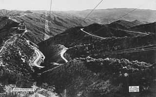
The Ridge Route, officially the Castaic–Tejon Route, was a two-lane highway between Los Angeles County and Kern County, California. Opened in 1915 and paved with concrete between 1917 and 1921, the road was the first paved highway directly linking the Los Angeles Basin with the San Joaquin Valley over the Tejon Pass and the rugged Sierra Pelona Mountains ridge south of Gorman. Much of the old road runs through the Angeles National Forest, and passes many historical landmarks, including the National Forest Inn, Reservoir Summit, Kelly's Half Way Inn, Tumble Inn, and Sandberg's Summit Hotel. North of the forest, the Ridge Route passed through Deadman's Curve before ending at Grapevine.

<span class="mw-page-title-main">Stevenson Ranch, California</span> Unincorporated community in California, United States

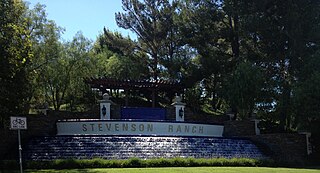
Stevenson Ranch is an unincorporated community in the Santa Clarita Valley of Los Angeles County, California. Stevenson Ranch is set in the foothills of the Santa Susana Mountains and lies west of Interstate 5 and the city of Santa Clarita. Stevenson Ranch encompasses about 6.4 square miles (17 km2). About 1,000 acres (4.0 km2) are set aside as parks, recreation areas, and open space. A master-planned community, it was approved by the county in 1987. The population was 20,178 at the time of the 2020 census. For statistical purposes, the Census Bureau has designated it a census-designated place (CDP).

<span class="mw-page-title-main">Newhall, Santa Clarita, California</span> Community of Santa Clarita in California, United States of America

Newhall is the southernmost and oldest community in the city of Santa Clarita, California. Prior to the 1987 consolidation of Canyon Country, Saugus, Newhall, and Valencia into the city of Santa Clarita, it was an unincorporated area. It was the first permanent town in the Santa Clarita Valley.

<span class="mw-page-title-main">Canyon Country, Santa Clarita, California</span> Neighborhood of Santa Clarita, California

Canyon Country is a neighborhood in the eastern part of the city of Santa Clarita, in northwestern Los Angeles County, California, United States. It lies along the Santa Clara River between the Sierra Pelona Mountains and the San Gabriel Mountains. It is the most populous of Santa Clarita's four neighborhoods.

<span class="mw-page-title-main">Saugus, Santa Clarita, California</span> Neighborhood of Santa Clarita in Los Angeles, California

Saugus is a neighborhood in Santa Clarita, California. It was one of four communities that merged in 1987 to create the city of Santa Clarita. Saugus includes the central and north-central portions of the city. It is named after Saugus, Massachusetts, the hometown of Henry Newhall, upon whose land the town was originally built.

<span class="mw-page-title-main">San Fernando Road</span> Major street in the City and County Los Angeles

San Fernando Road is a major street in the City of Los Angeles and Los Angeles County. Within the Burbank city limits it is signed as San Fernando Boulevard, and north of Newhall Pass it is signed as The Old Road. It was previously designated as Business Loop 5 in the 1970s.

The Newhall School District is an elementary school district in the Santa Clarita Valley that serves the Valencia and Newhall communities within the city of Santa Clarita, California, as well as the Stevenson Ranch community in unincorporated Los Angeles County. It currently includes ten schools.

Saugus Union School District (SUSD) is a public California school district located in Santa Clarita, Los Angeles County, California. The district serves students in grades TK/K-6 in Saugus, most of Valencia, and parts of Canyon Country. There are also pre-school programs on-site at many of the schools. The district includes 15 elementary schools.

Bouquet Canyon, also known as Hangman's Canyon and Dead Man's Canyon, is a canyon in Los Angeles County, California.

<span class="mw-page-title-main">Castaic Junction, California</span> Unincorporated community in California, United States

Castaic Junction is an unincorporated community located in Los Angeles County, California. It is located at the crossroads of Interstate 5 and State Route 126 near the confluence of Castaic Creek and the Santa Clara River.

<span class="mw-page-title-main">Santa Clarita, California</span> City in California, United States

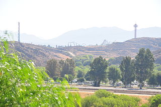
Santa Clarita is a city in northwestern Los Angeles County in the U.S. state of California. With a 2020 census population of 228,673, it is the third-largest city by population in Los Angeles County, the 17th-largest in California, and the 98th-largest city in the United States. It is located about 30 miles (48 km) northwest of downtown Los Angeles, and occupies 70.75 square miles (183.2 km2) of land in the Santa Clarita Valley, along the Santa Clara River. It is a classic example of a U.S. edge city, satellite city, or boomburb.

<span class="mw-page-title-main">City of Santa Clarita Transit</span> Public transit agency serving the Santa Clarita Valley

City of Santa Clarita Transit is a local bus service, administered by the City's transit division, that serves the City of Santa Clarita, California and nearby surrounding unincorporated areas. In 2022, the system had a ridership of 2,111,800, or about 9,000 per weekday as of the second quarter of 2023. Daily operations and maintenance of the fleet are under contract with MV Transportation. City of Santa Clarita Transit routes connect with services operated by Metro and Metrolink.

<span class="mw-page-title-main">Valencia, California</span> Community in Los Angeles County, California, United States

Valencia is an unincorporated community in northwestern Los Angeles County, California, United States. The area, with major commercial and industrial parks, straddles State Route 126 and the Santa Clara River.

Castaic Union School District is a public school district serving unincorporated Castaic, portions of unincorporated Valencia, and a very small portion of the city of Santa Clarita within Los Angeles County, California, offering elementary and secondary instruction, grades pre-K through eighth. Until 1890, it was known as the "Castec School District."

<span class="mw-page-title-main">Lang Southern Pacific Station</span> Historic site in Los Angeles County, California

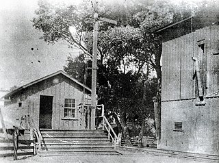
Lang Southern Pacific Station is a former Southern Pacific railway station located in Soledad Canyon near the eastern end of Santa Clarita, California. On September 5, 1876 the first railway to Los Angeles was completed at this site. The Lang Southern Pacific Station was designated a California Historic Landmark on May 22, 1957.

<span class="mw-page-title-main">Tick Fire</span> Wildfire that burned in the Sierra Pelona near Santa Clarita, California in October 2019

The Tick Fire was a wildfire that burned in Los Angeles County, California. The fire broke out on October 24, 2019, and burned several thousand acres. The fire forced the mass evacuation of 40,000 people from the Santa Clarita Valley.

<span class="mw-page-title-main">McBean Regional Transit Center</span> Transit center in Santa Clarita, California

McBean Regional Transit Center, also known by its acronym MRTC, is a transit center and bus station located at 24375 Valencia Boulevard in the Valencia area of Santa Clarita, California, near the intersection of Valencia Boulevard and McBean Parkway. It is located next to the Westfield Valencia Town Center.

References

  1. "'Awesometown' ad campaign spurs buzz for Valencia". Los Angeles Times. September 23, 2010. Retrieved May 4, 2021.
  2. elevation.maplogs.com (McBean Parkway and Magic Mountain Parkway)
  3. "Total Population". U.S. Census Bureau. Retrieved April 17, 2021.
  4. Boston, John; Santa Clarita Valley Historical Society (2009). Santa Clarita Valley. Charleston, SC: Arcadia Publishing. p. 124. ISBN   9780738569383 . Retrieved August 20, 2016.
  5. 1 2 "Santa Clarita neighborhoods". Google My Maps.
  6. "Welcome Members". portal.ipsmanage.com.
  7. Bolton, Herbert E. (1927). Fray Juan Crespi: Missionary Explorer on the Pacific Coast, 1769–1774. HathiTrust Digital Library. pp. 152–155. Retrieved April 8, 2014.
  8. "Old Orchard I: Park, Paseos, Streets". scvhistory.com. Retrieved June 15, 2021.
  9. "Valencia, CA - Paul Walker Crash Site". RoadsideAmerica.com. Retrieved May 21, 2023.
  10. "Completed Annexations". City of Santa Clarita. Retrieved December 25, 2020.
  11. "Tallest buildings in Santa Clarita". Emporis. Archived from the original on May 13, 2021. Retrieved April 3, 2021.
  12. "Contact Information". City of Santa Clarita. Retrieved September 5, 2021.
  13. "California ZIP Codes List, Map, Demographics, and Shipping". United States ZIP Codes. Retrieved April 17, 2021.
  14. United States Census results obtained via Dave's Redistricting. Valencia is here defined as the area of Santa Clarita west of San Francisquito Canyon Road/Copper Hill Drive/Seco Canyon Road/Bouquet Canyon Road/Railroad Avenue and north of Lyons Avenue, excluding the small area between Hart High School and Railroad Avenue. (area 2 on this map)
  15. 1 2 "Wm. S. Hart Union High SD". SchoolSite Locator. Retrieved December 25, 2020.
  16. "The Newhall Land and Farming Company". Encyclopedia of Company Histories. The Gale Group. Retrieved April 20, 2007.
  17. MacDonald, Brady (May 2, 2012). "Six Flags Magic Mountain to reclaim roller coaster title". Los Angeles Times . Retrieved January 8, 2021.
  18. Darmiento, Laurence (April 1, 2002). "Spotlight on Valencia". Los Angeles Business Journal. Retrieved April 25, 2021.
  19. "Westfield Valencia Town Center". Westfield. Retrieved January 8, 2020.
  20. "The Patios Connection Project". Westfield. Retrieved February 25, 2021.
  21. "Westfield Valencia Town Center (stores)". Westfield. Retrieved January 8, 2020.
  22. "Westfield Valencia Town Center (restaurants)". Westfield. Retrieved January 8, 2020.
  23. "'The Cube': City reveals ice rink's new name". Santa Clarita Valley Signal. March 5, 2021. Retrieved March 17, 2021.
  24. "City Council OKs L.A. Kings, partner as new operators of ice rink". Santa Clarita Valley Signal. February 23, 2021. Retrieved February 24, 2021.
  25. Miranda, Bill (March 12, 2021). "Ready to welcome the community to The Cube". Santa Clarita Valley Signal. Retrieved March 17, 2021.
  26. Miller, Devon (March 16, 2021). "Opening Date Set For The Cube Ice And Entertainment Center". Valley Post News. Retrieved March 17, 2021.
  27. "Global Offices". Advanced Bionics. Retrieved April 15, 2021.
  28. "Zipcode 91354". www.plantmaps.com. Retrieved March 12, 2021.
  29. Beach volleyball information page
  30. Mertes, Micah (November 21, 2016). "Omaha native film editor goes from 'Frozen' to new Disney film 'Moana'". Omaha World-Herald.
  31. Lisa Dillman (August 14, 2000). "Winning Isn't Only Thing in Men's 100 Freestyle". Los Angeles Times.
  32. "Taylor Lautner Wants to Go Back to School". Extratv.warnerbros.com. June 29, 2010.
  33. Paul Richter (1994). "Myers' Future White House Role Uncertain". Los Angeles Times.
  34. "Naya Rivera Bio". UsMagazine.com.
  35. "Michael Trevino Biography". Mostbeautifulman.com. Archived from the original on February 2, 2015.
  36. Berry, Zuri (April 29, 2011). "Patriots select RB Shane Vereen with the 56th pick". NY Times Co.
  37. "PLAYBOY Playmates". wekinglypigs.com.
  38. Smith, Perry (November 30, 2013). "Paul Walker, Santa Clarita CEO Reportedly Killed in Fatal Single-Car Crash". KHTS Radio.