
The Columbia River is the largest river in the Pacific Northwest region of North America. The river rises in the Rocky Mountains of British Columbia, Canada. It flows northwest and then south into the US state of Washington, then turns west to form most of the border between Washington and the state of Oregon before emptying into the Pacific Ocean. The river is 1,243 miles (2,000 km) long, and its largest tributary is the Snake River. Its drainage basin is roughly the size of France and extends into seven US states and a Canadian province. The fourth-largest river in the United States by volume, the Columbia has the greatest flow of any North American river entering the Pacific. The Columbia has the 37th greatest discharge of any river in the world.

Clark County is the southernmost county in the U.S. state of Washington. As of the 2010 census, the population was 425,363, making it Washington's fifth-most populous county. Its county seat and largest city is Vancouver. It was the first county in Washington, named after William Clark of the Lewis and Clark Expedition. It was created by the provisional government of Oregon Territory on August 20, 1845, and at that time covered the entire present-day state.

Vancouver Island is an island in the northeastern Pacific Ocean and part of the Canadian province of British Columbia. The island is 456 km (283 mi) in length, 100 km (62 mi) in width at its widest point, and 32,134 km2 (12,407 sq mi) in area. The island is the largest by area and the most populous along the west coasts of the Americas.
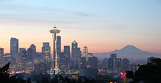
The Pacific Northwest (PNW), is a geographic region in western North America bounded by its coastal waters of the Pacific Ocean to the west and, loosely, by the Rocky Mountains to the east. Though no official boundary exists, the most common conception includes the U.S. states of Oregon, Washington, and Idaho and the Canadian province of British Columbia. Some broader conceptions reach north into Alaska and Yukon and south into northern California. Other conceptions may be limited to the coastal areas west of the Cascade and Coast mountains. The variety of definitions can be attributed to partially overlapping commonalities of the region's history, culture, geography, society, and other factors. The city of Seattle in Washington is sometimes considered the "capital" of the Pacific Northwest, while Portland, Oregon and Vancouver, British Columbia are also generally included in the region.

The Willamette River is a major tributary of the Columbia River, accounting for 12 to 15 percent of the Columbia's flow. The Willamette's main stem is 187 miles (301 km) long, lying entirely in northwestern Oregon in the United States. Flowing northward between the Oregon Coast Range and the Cascade Range, the river and its tributaries form the Willamette Valley, a basin that contains two-thirds of Oregon's population, including the state capital, Salem, and the state's largest city, Portland, which surrounds the Willamette's mouth at the Columbia.
Wishram is an unincorporated community and census-designated place (CDP) in Klickitat County, Washington, United States. The population was 342 at the 2010 census, up from 213 at the 2000 census. The site of the historic Celilo Falls is nearby.

Multnomah Falls is a waterfall located on Multnomah Creek in the Columbia River Gorge, east of Troutdale, between Corbett and Dodson, Oregon, United States. The waterfall is accessible from the Historic Columbia River Highway and Interstate 84. Spanning two tiers on basalt cliffs, it is the tallest waterfall in the state of Oregon at 620 ft (189 m) in height.
The Confluence Project is a series of outdoor installations and interpretive artworks located in public parks along the Columbia River and its tributaries in the U.S. states of Washington and Oregon. Each art installation explores the confluence of history, culture and ecology of the Columbia River system. The project draws on the region's history, including Native American traditional stories and entries from the Lewis and Clark Expedition journals, to "evoke a landscape and a way of life submerged in time and memory." The project reaches from the mouth of the Columbia River to Hells Canyon.

Gifford Pinchot National Forest is a National Forest located in southern Washington, USA, managed by the United States Forest Service. With an area of 1.32 million acres (5300 km2), it extends 116 km along the western slopes of Cascade Range from Mount Rainier National Park to the Columbia River. The forest straddles the crest of the South Cascades of Washington State, spread out over broad, old growth forests, high mountain meadows, several glaciers, and numerous volcanic peaks. The forest's highest point is at 12,276 ft. at the top of Mount Adams, the second tallest volcano in the state after Rainier. Often found abbreviated GPNF on maps and in texts, it includes the 110,000-acre (450 km2) Mount St. Helens National Volcanic Monument, established by Congress in 1982.

The Skagit River is a river in southwestern British Columbia in Canada and northwestern Washington in the United States, approximately 150 mi (240 km) long. The river and its tributaries drain an area of 1.7 million acres (690,000 hectares) of the Cascade Range along the northern end of Puget Sound and flows into the sound.
The Multnomah are a tribe of Chinookan people who live in the area of Portland, Oregon, in the United States. Multnomah villages were located throughout the Portland basin and on both sides of the Columbia River. The Multnomah speak a dialect of the Upper Chinookan language in the Oregon Penutian family.

The Interstate Bridge is a pair of nearly identical steel vertical-lift, "Parker type" through-truss bridges that carry Interstate 5 traffic over the Columbia River between Vancouver, Washington and Portland, Oregon in the United States.

The Astoria–Megler Bridge is a steel cantilever through truss bridge in the northwest United States that spans the lower Columbia River, between Astoria, Oregon, and Point Ellice near Megler, Washington. Opened 55 years ago in 1966, it is the longest continuous truss bridge in North America.
State Route 14 (SR 14) is a 180.66-mile-long (290.74 km) state highway in the U.S. state of Washington. The highway travels east-west on the north side of the Columbia River, opposite Interstate 84 (I-84) to the south in Oregon. SR 14 forms a section of the Lewis and Clark Trail Scenic Byway and begins at an interchange with I-5 in Vancouver. The highway travels east as a four-lane freeway through Camas and Washougal and intersects I-205. SR 14 continues east as a two-lane highway through Clark, Skamania, Klickitat, and Benton counties before it ends at an interchange with I-82 and U.S. Route 395 (US 395) near Plymouth.

The history of Washington includes thousands of years of Native American history before Europeans arrived and began to establish territorial claims. The region was part of Oregon Territory from 1848 to 1853, after which it was separated from Oregon and established as Washington Territory following the efforts at the Monticello Convention. In 1889, Washington became the 42nd state of the United States.

The Syilx people, also known as the Okanagan or Okanogan people, are a First Nations and Native American people whose traditional territory spans the Canada–US boundary in Washington state and British Columbia in the Okanagan Country region. They are part of the Interior Salish ethnological and linguistic grouping. The Syilx are closely related to the Spokan, Sinixt, Nez Perce, Pend Oreille, Secwepemc and Nlaka'pamux peoples of the same Northwest Plateau region.

The Coast Salish is a group of ethnically and linguistically related Indigenous peoples of the Pacific Northwest Coast, living in British Columbia, Canada and the U.S. states of Washington and Oregon. They speak one of the Coast Salish languages. The Nuxalk nation are usually included in the group, although their language is more closely related to Interior Salish languages.
The Indigenous peoples of the Pacific Northwest Coast are composed of many nations and tribal affiliations, each with distinctive cultural and political identities. They share certain beliefs, traditions and practices, such as the centrality of salmon as a resource and spiritual symbol, and many cultivation and subsistence practices. The term Northwest Coast or North West Coast is used in anthropology to refer to the groups of Indigenous people residing along the coast of what is now called British Columbia, Washington state, parts of Alaska, Oregon, and Northern California. The term Pacific Northwest is largely used in the American context.
Washington, officially the State of Washington, is a state in the Pacific Northwest region of the Western United States. Named for George Washington—the first U.S. president—the state was formed from the western part of the Washington Territory, which was ceded by the British Empire in 1846, in accordance with the Oregon Treaty in the settlement of the Oregon boundary dispute. The state—which is bordered on the west by the Pacific Ocean, Oregon to the south, Idaho to the east, and the Canadian province of British Columbia to the north—was admitted to the Union as the 42nd state in 1889. Olympia is the state capital; the state's largest city is Seattle. Washington is often referred to as Washington state to distinguish it from the nation's capital, Washington, D.C.

Vancouver is a city on the north bank of the Columbia River in the U.S. state of Washington, located in Clark County. Incorporated in 1857, Vancouver had a population of 161,791 as of the 2010 U.S. census, and a population of 186,192 as of the 2020 U.S census, making it the fourth-largest city in Washington state. Vancouver is the county seat of Clark County and forms part of the Portland-Vancouver metropolitan area, the 25th largest metropolitan area in the United States. Originally established in 1825 around Fort Vancouver, a fur-trading outpost, the city is located on the Washington–Oregon border along the Columbia River, directly north of Portland.


