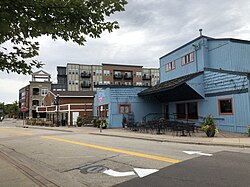
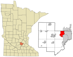
Victoria, Minnesota

Last updated

Victoria
Downtown Victoria, Minnesota, Sept 2019 3.jpg
Downtown Victoria
Carver County Minnesota Incorporated and Unincorporated areas Victoria Highlighted.svg
Location of the city of Victoria
within Carver County, Minnesota
Coordinates: 44°51′51″N93°38′57″W / 44.86417°N 93.64917°W / 44.86417; -93.64917
CountryUnited States
State Minnesota
County Carver
Area
[1]
  Total10.69 sq mi (27.70 km2)
  Land8.71 sq mi (22.57 km2)
  Water1.98 sq mi (5.13 km2)
Elevation
[2]
958 ft (292 m)
Population
 (2020) [3]
  Total10,546
  Estimate 
(2021) [4]
11,042
  Density1,210.38/sq mi (467.34/km2)
Time zone UTC-6 (CST)
  Summer (DST) UTC-5 (CDT)
ZIP code
55386
Area code 952
FIPS code 27-67036 [5]
GNIS feature ID2397135 [2]
Website ci.victoria.mn.us

Victoria is a city in Carver County, Minnesota, United States. The population was 10,546 at the 2020 census. [3]

Contents

Geography

Looking east on MN 5 into Victoria Ictoria.jpg
Looking east on MN 5 into Victoria

According to the United States Census Bureau, the city has an area of 9.79 square miles (25.36 km2), of which 8.01 square miles (20.75 km2) is land and 1.78 square miles (4.61 km2) is water. [6]

State Highways 5 and 7 are two of Victoria's main routes.

Victoria has been nicknamed "The City of Lakes and Parks" because it has over 200 acres (0.81 km2) of reserved land, 13 parks, and nine lakes within its borders. Victoria is also home to the 1,800-acre (7.3 km2) Carver Park Reserve.

In the 1850s, Victoria's rich soil attracted many farmers from Germany, Switzerland, and the Netherlands.

History

Michael Diethelm is believed to be the first settler in Victoria after setting up a shelter for his wife and two children in 1851 near the present-day St. Victoria Church. The city is named after the church, built on 30 acres (120,000 m2) of land just north of Lake Bavaria in 1857. A year later, steamboats from St. Paul began bringing additional supplies for early settlers. The settlement continued to grow as the rich soil attracted farmers. Also in 1858, the Laketown Moravian Brethren's Church was established and is now on the National Register of Historic Places. [7] Eventually the steamboats to Chaska and the St. Paul railroad helped transform the area into a thriving community. [8]

Demographics

Historical population
CensusPop.Note
1920 206
1930 24016.5%
1940 27615.0%
1950 3029.4%
1960 42540.7%
1970 850100.0%
1980 1,42567.6%
1990 2,35465.2%
2000 4,02571.0%
2010 7,34582.5%
2020 10,54643.6%
2021 (est.)11,042 [4] 4.7%
U.S. Decennial Census [9]
2020 Census [3]

2010 census

As of the census of 2010, 7,345 people, 2,435 households, and 2,055 families lived in the city. The population density was 917.0 inhabitants per square mile (354.1/km2). There were 2,545 housing units at an average density of 317.7 per square mile (122.7/km2). The racial makeup of the city was 95.6% White, 0.5% African American, 0.1% Native American, 2.0% Asian, 0.3% from other races, and 1.5% from two or more races. Hispanic or Latino of any race were 2.0% of the population.

There were 2,435 households, of which 49.4% had children under the age of 18 living with them, 76.7% were married couples living together, 5.4% had a female householder with no husband present, 2.3% had a male householder with no wife present, and 15.6% were non-families. 12.6% of all households were made up of individuals, and 4.3% had someone living alone who was 65 years of age or older. The average household size was 2.99 and the average family size was 3.27.

The median age in the city was 38.9 years. 32.9% of residents were under the age of 18; 4.5% were between the ages of 18 and 24; 25.5% were from 25 to 44; 28.6% were from 45 to 64; and 8.5% were 65 years of age or older. The gender makeup of the city was 49.7% male and 50.3% female.

2000 census

As of the census of 2000, there were 4,025 people, 1,367 households, and 1,141 families living in the city. The population density was 575.4 inhabitants per square mile (222.2/km2). There were 1,410 housing units at an average density of 201.6 per square mile (77.8/km2). The racial makeup of the city was 97.91% White, 0.27% African American, 0.12% Native American, 0.84% Asian, 0.37% from other races, and 0.47% from two or more races. Hispanic or Latino of any race were 0.99% of the population.

There were 1,367 households, out of which 47.0% had children under the age of 18 living with them, 76.0% were married couples living together, 5.3% had a female householder with no husband present, and 16.5% were non-families. 11.3% of all households were made up of individuals, and 3.4% had someone living alone who was 65 years of age or older. The average household size was 2.90 and the average family size was 3.17.

In the city, the population was spread out, with 31.7% under the age of 18, 4.2% from 18 to 24, 33.5% from 25 to 44, 24.0% from 45 to 64, and 6.6% who were 65 years of age or older. The median age was 36 years. For every 100 females, there were 99.4 males. For every 100 females age 18 and over, there were 97.8 males.

The median income for a household in the city was $86,772, and the median income for a family was $91,681. Males had a median income of $60,931 versus $34,519 for females. The per capita income for the city was $38,929. About 1.3% of families and 2.3% of the population were below the poverty line, including 2.1% of those under age 18 and 2.2% of those age 65 or over.

Politics

Presidential election results
2020 Precinct Results Spreadsheet [10] 2016 Precinct Results Spreadsheet [11] 2012 Precinct Results Spreadsheet [12] 2008 Precinct Results Spreadsheet [13] 2004 Precinct Results Spreadsheet [14] 2000 Precinct Results Spreadsheet [15] 1996 Precinct Results [16] 1992 Precinct Results [17] 1988 Precinct Results [18] 1984 Precinct Results [19] 1980 Precinct Results [20] 1976 Precinct Results [21] 1968 Precinct Results [22] 1964 Precinct Results [23] 1960 Precinct Results [24]
Year Republican Democratic Third parties
2020 51.7%3,63846.1% 3,2432.2% 157
2016 53.7%2,80837.6% 1,9688.7% 453
2012 65.0%3,01134.0% 1,5741.0% 49
2008 61.3%2,51037.3% 1,5271.4% 56
2004 68.0%2,30331.2% 1,0570.7% 25
2000 62.6%1,47033.3% 7824.1% 95
1996 48.9%85738.8% 68012.3% 216
1992 40.5%61929.1% 44430.4% 464
1988 65.7%73534.3% 3830.0% 0
1984 71.1%67828.9% 2760.0% 0
1980 56.8%41533.6% 2459.6% 70
1976 59.2%30837.1% 1933.7% 19
1972 62.1%26433.9% 1444.0% 17
1968 62.1%22534.0% 1233.9% 14
1964 46.6% 9653.4%1100.0% 0
1960 39.9% 7360.1%1100.1% 1

Education

District 112 schools have an elementary school, Victoria Elementary.

Chanhassen High School serves the majority of Victoria. [25]

Waconia Public Schools operates area public schools serving other parts of Victoria, [26] including Waconia High School.

The city is home to the co-ed college preparatory high school Holy Family Catholic High School.

Related Research Articles

Benton Township is a rural township in Carver County, Minnesota, United States. The population was 939 as of the 2000 census.

Camden Township is a rural township in Carver County, Minnesota, United States. The population was 955 as of the 2000 census.

Dahlgren Township is a rural township in Carver County, Minnesota, United States. The township's economy is based on commercial agriculture around dairying, livestock and cash grain farming. The population was 1,453 as of the 2000 census.

<span class="mw-page-title-main">Hancock Township, Carver County, Minnesota</span> Township in Minnesota, United States

Hancock Township is a township in Carver County, Minnesota, United States. The population was 367 as of the 2000 census.

Laketown Township is a township in Carver County, Minnesota, United States. The population was 2,331 as of the 2000 census.

<span class="mw-page-title-main">Manhattan Beach, Minnesota</span> City in Minnesota, United States

Manhattan Beach is a small city in Crow Wing County, Minnesota, United States, near Crosslake. The population was 57 at the 2010 census. It is part of the Brainerd Micropolitan Statistical Area.

<span class="mw-page-title-main">Nisswa, Minnesota</span> City in Minnesota, United States

Nisswa is a city in Crow Wing County, Minnesota, United States. The population was 1,971 at the 2010 census. Nisswa is part of the Brainerd Micropolitan Statistical Area, near Gull Lake.

<span class="mw-page-title-main">Apple Valley, Minnesota</span> City in Minnesota, United States

Apple Valley is a city in northwestern Dakota County in the State of Minnesota, and a suburb of the Twin Cities. The population was 56,374 at the 2020 census, making it the 17th most populous city in Minnesota. In 2014, Money.com named Apple Valley the 17th best place to live in the United States, up from 20th in 2010, 24th in 2008 and 28th in 2007. And it also the host for Scott Highlands Middle School a national blue ribbon school placed in the city of Apple Valley, Minnesota.

<span class="mw-page-title-main">Lakeville, Minnesota</span> City in Minnesota, United States

Lakeville is an exurb of Minneapolis-Saint Paul, and the largest city in Dakota County, Minnesota, United States. It is approximately 20 miles (32 km) south of both downtown Minneapolis and downtown St. Paul along Interstate Highway 35. Starting as a flourishing milling center, its agriculture industry and other major industries are still in operation. Lakeville is one of the fastest-growing cities in the Twin Cities area. The population was 69,490 at the 2020 census. making it Minnesota's tenth most populous city.

<span class="mw-page-title-main">Mendota Heights, Minnesota</span> City in Minnesota, United States

Mendota Heights is a city in Dakota County, Minnesota, United States. It is a first-ring southern suburb of the Twin Cities. The population was 11,744 at the 2020 census.

<span class="mw-page-title-main">Greenfield, Minnesota</span> City in Minnesota, United States

Greenfield is a city in northwestern Hennepin County, Minnesota. It has a population of 2,903 residents, according to the 2020 United States Census, and is located 26.5 miles northwest of Minneapolis. It is part of the Twin Cities Metropolitan Statistical Area.

<span class="mw-page-title-main">Long Lake, Minnesota</span> City in Minnesota, United States

Long Lake is a small city in Hennepin County, Minnesota, United States named after the lake the eastern end of town lies on. A commercial hub for the surrounding communities, Long Lake is home to many local shops and businesses. U.S. Highway 12 runs through the town. The population was 1,768 at the 2010 census.

<span class="mw-page-title-main">Glencoe, Minnesota</span> City in the United States

Glencoe is a city and the county seat of McLeod County, Minnesota, United States. The population was 5,744 at the 2020 census.

<span class="mw-page-title-main">Lester Prairie, Minnesota</span> City in Minnesota, United States

Lester Prairie is a city in McLeod County, Minnesota, United States, along the South Fork of the Crow River. The population was 1,894 at the 2020 census.

<span class="mw-page-title-main">Red Lake Falls, Minnesota</span> City in Minnesota, United States

Red Lake Falls is a city and the county seat of Red Lake County, Minnesota, United States. The population was 1,339 at the 2020 census. It is the county seat of Red Lake County. The city lies in the middle of Red Lake Falls Township, from which it was separated when incorporated as a village in 1881. Its status was raised to that of a city in 1898.

<span class="mw-page-title-main">Cokato, Minnesota</span> City in Minnesota, United States

Cokato is a city in Wright County, Minnesota, United States. The population was 2,799 at the 2020 census.

<span class="mw-page-title-main">Montrose, Minnesota</span> City in Minnesota, United States

Montrose is a small city in Wright County, Minnesota, United States. Montrose is surrounded by farmland, prairies, and lakes. The population was 2,847 at the 2010 census.

<span class="mw-page-title-main">New Germany, Minnesota</span> City in Minnesota, United States

New Germany is a city in Carver County, Minnesota, United States. The population was 372 at the 2010 census. A large proportion of the early settlers being natives of Germany caused the name to be selected.

<span class="mw-page-title-main">Arden Hills, Minnesota</span> City in Minnesota, United States

Arden Hills is a city in Ramsey County, Minnesota, United States. The population was 9,939 at the 2020 census. Bethel University and its seminary is located in the city. Also, the campus of University of Northwestern – St. Paul straddles the Arden Hills – Roseville border. The city contains the headquarters of Land O'Lakes and Catholic United Financial, a fraternal benefit society. Boston Scientific also has a large campus within Arden Hills as well.

<span class="mw-page-title-main">Howard Lake, Minnesota</span> City in Minnesota, United States

Howard Lake is a city in Wright County, Minnesota, United States. It is the host of the annual Wright county fair. The population was 1,962 at the 2010 census.

References

  1. "2020 U.S. Gazetteer Files". United States Census Bureau. Archived from the original on July 24, 2022. Retrieved July 24, 2022.
  2. 1 2 U.S. Geological Survey Geographic Names Information System: Victoria, Minnesota
  3. 1 2 3 "Explore Census Data". United States Census Bureau . Retrieved March 12, 2023.
  4. 1 2 "City and Town Population Totals: 2020-2021". United States Census Bureau. March 12, 2023. Retrieved March 12, 2023.
  5. "U.S. Census website". United States Census Bureau. Archived from the original on December 27, 1996. Retrieved January 31, 2008.
  6. "US Gazetteer files 2010". United States Census Bureau. Archived from the original on February 20, 2011. Retrieved November 13, 2012.
  7. Lofstrom, Ted (January 1978). "Minnesota Historic Properties Inventory Form: Laketown Moravian Brethren's Church". National Park Service. Archived from the original on February 24, 2022. Retrieved January 30, 2016.
  8. "City of Victoria, MN: History of Victoria". City of Victoria. Archived from the original on May 8, 2015. Retrieved April 11, 2015.
  9. United States Census Bureau. "Census of Population and Housing" . Retrieved July 14, 2014.
  10. "Minnesota Secretary of State - 2020 Precinct Results Spreadsheet". Archived from the original on April 10, 2021. Retrieved April 16, 2021.
  11. "Minnesota Secretary of State - 2016 Precinct Results Spreadsheet". Archived from the original on April 10, 2021. Retrieved April 16, 2021.
  12. "Minnesota Secretary of State - 2012 Precinct Results Spreadsheet". Archived from the original on April 10, 2021. Retrieved April 16, 2021.
  13. "Minnesota Secretary of State - 2008 Precinct Results Spreadsheet". Archived from the original on April 10, 2021. Retrieved April 16, 2021.
  14. "Minnesota Secretary of State - 2004 Precinct Results Spreadsheet". Archived from the original on April 10, 2021. Retrieved April 16, 2021.
  15. "Minnesota Secretary of State - 2000 Precinct Results Spreadsheet". Archived from the original on April 10, 2021. Retrieved April 16, 2021.
  16. "Archived copy" (PDF). Archived (PDF) from the original on April 10, 2021. Retrieved April 16, 2021.{{cite web}}: CS1 maint: archived copy as title (link)
  17. "Archived copy" (PDF). Archived (PDF) from the original on April 10, 2021. Retrieved April 16, 2021.{{cite web}}: CS1 maint: archived copy as title (link)
  18. "Archived copy" (PDF). Archived (PDF) from the original on April 10, 2021. Retrieved April 16, 2021.{{cite web}}: CS1 maint: archived copy as title (link)
  19. "Archived copy" (PDF). Archived (PDF) from the original on April 10, 2021. Retrieved April 16, 2021.{{cite web}}: CS1 maint: archived copy as title (link)
  20. "Archived copy" (PDF). Archived (PDF) from the original on April 10, 2021. Retrieved April 16, 2021.{{cite web}}: CS1 maint: archived copy as title (link)
  21. "Archived copy" (PDF). Archived (PDF) from the original on April 10, 2021. Retrieved April 16, 2021.{{cite web}}: CS1 maint: archived copy as title (link)
  22. "Archived copy" (PDF). Archived (PDF) from the original on April 10, 2021. Retrieved April 16, 2021.{{cite web}}: CS1 maint: archived copy as title (link)
  23. "Archived copy" (PDF). Archived (PDF) from the original on April 10, 2021. Retrieved April 16, 2021.{{cite web}}: CS1 maint: archived copy as title (link)
  24. "Archived copy" (PDF). Archived (PDF) from the original on April 10, 2021. Retrieved April 16, 2021.{{cite web}}: CS1 maint: archived copy as title (link)
  25. "Chanhassen High School - School Boundaries Map (School Attendance Zone)". Minnesota HomeTownLocator . Archived from the original on June 8, 2020. Retrieved June 8, 2020.
  26. "Why Waconia". Waconia Public Schools. Archived from the original on March 29, 2020. Retrieved March 28, 2020.