Villanueva, Zacatecas

Last updated
Villanueva, Zacatecas
Templo villanueva.jpg
Jardín Principal and San joseeo Church
Mexico Zacatecas location map.svg
Red pog.svg
Villanueva, Zacatecas
Mexico States blank map.svg
Red pog.svg
Villanueva, Zacatecas
Coordinates: 22°21′13″N102°52′59″W / 22.35361°N 102.88306°W / 22.35361; -102.88306
CountryFlag of Mexico.svg  Mexico
State Zacatecas
Municipality Villanueva
Founded1692
Government
  MayorMiguel Torres (PAN)
Elevation
1,900 m (6,200 ft)
Population
 (2005)
  Total32,835
Time zone UTC-6 (Central)
Postal code
99540
Website https://www.villanueva.gob.mx/

Villanueva is a city in the Mexican state of Zacatecas. It is the administrative seat of the municipality of Villanueva.

Contents

Name

Villanueva was founded on February 4, 1692, under the name Villagutierre del Águila. Like many towns in Mexico, the name of the patron saint of the town was added to the name – in this case, that of Judas Thaddaeus – and it became Villa de San Judas Tadeo de Villa Gutierre del Águila. However, since it was the last town founded in that area of Zacatecas, it was called Villa Nueva (new town), and that is the name that stuck.

Geography

Villanueva is one of the 58 municipalities in the state of Zacatecas. It is located at the southern part of Zacatecas and is bordered in all directions by a number of Zacatecas municipalities. Among the municipalities bordering it are Jerez to the north, Genero Codina to the east, Tabasco to the south and Tepetongo to the west. Some parts of Villanueva have mountainous terrains. It is also crossed by different rivers and other bodies of fresh water. It has a sub-humid temperature and an annual average of 16.9 °C.

Climate

Climate data for Villanueva (1951–2010)
MonthJanFebMarAprMayJunJulAugSepOctNovDecYear
Record high °C (°F)30.0
(86.0)
32.0
(89.6)
33.0
(91.4)
37.0
(98.6)
39.5
(103.1)
39.5
(103.1)
35.5
(95.9)
35.0
(95.0)
34.0
(93.2)
39.5
(103.1)
35.0
(95.0)
33.0
(91.4)
39.5
(103.1)
Average high °C (°F)21.7
(71.1)
23.5
(74.3)
25.4
(77.7)
28.2
(82.8)
30.2
(86.4)
29.2
(84.6)
27.0
(80.6)
27.2
(81.0)
26.2
(79.2)
25.9
(78.6)
25.2
(77.4)
22.6
(72.7)
26.0
(78.8)
Daily mean °C (°F)11.7
(53.1)
13.2
(55.8)
14.8
(58.6)
17.8
(64.0)
20.4
(68.7)
20.9
(69.6)
19.8
(67.6)
19.6
(67.3)
19.0
(66.2)
17.2
(63.0)
14.7
(58.5)
12.5
(54.5)
16.8
(62.2)
Average low °C (°F)1.8
(35.2)
2.9
(37.2)
4.1
(39.4)
7.5
(45.5)
10.7
(51.3)
12.6
(54.7)
12.5
(54.5)
12.1
(53.8)
11.8
(53.2)
8.4
(47.1)
4.1
(39.4)
2.5
(36.5)
7.6
(45.7)
Record low °C (°F)−8.5
(16.7)
−6.0
(21.2)
−5.0
(23.0)
−4.0
(24.8)
1.5
(34.7)
4.0
(39.2)
3.0
(37.4)
2.0
(35.6)
0.0
(32.0)
−2.5
(27.5)
−6.0
(21.2)
−9.0
(15.8)
−9.0
(15.8)
Average precipitation mm (inches)20.5
(0.81)
16.4
(0.65)
7.0
(0.28)
6.1
(0.24)
15.6
(0.61)
88.8
(3.50)
120.3
(4.74)
116.5
(4.59)
82.5
(3.25)
35.8
(1.41)
12.1
(0.48)
12.2
(0.48)
533.8
(21.02)
Average precipitation days (≥ 0.1 mm)2.71.70.81.03.18.913.413.110.05.11.92.163.8
Source: Servicio Meteorologico Nacional [1] [2]

History

The municipality was originally called Santa Cruz when it was founded in 1650. Its name was changed a couple of times until 1962, when it was officially renamed as the Municipality of Villanueva, its name until the present. Its seal is one of the oldest in Zacatecas, dating back as early as the early 19th century. The motto of the town is the Latin translation of "With the sword and the plow". It is because Villanueva began as an agriculture and labor-based community and produced some of the bravest patriots in Mexico. Once a colonial town, Villanueva only became a free municipality in the year 1917. As of 2005, Villanueva had a population of 28,760 residents. The majority of these residents are Roman Catholics by faith.

Economy and culture

The primary sources of income in Villanueva are agriculture, cattle raising and fishing. Following it are the manufacturing, construction and electricity industry. Commerce and tourism over the years have also become sources of income for the municipality. Villanueva has great potential to be developed as a tourism hot spot because of its attractive colonial architecture. It has plenty of historical sites to visit. Among these are pre-Hispanic petroglyphs, the properties of the old colonial invaders, the parochial temple of San Judas Tadeo, the Municipal Palace and a whole lot more. The annual feast from October 20–28 is also one of the most joyous celebrations in Villanueva. It is held in honor of their patron saint San Judas Tadeo and is reveled with merriment, dances, food and games. Some popular events are the Fair of Tayahua every March 14–20 and the religious celebration of the Incarnation of The Blessed Virgin Mary of Carmen every July 16 among others.

Culture

People in Villanueva are musically inclined. In fact, it is the place of origin of the musical genre called tamborazo. It is also rich in craft products such as wood and leather furniture. The place also has a number of original delicious Mexican recipes to feast on. On account of its many vacation attractions, it has been a preference by both local and foreign tourists. To cater to the tourists that flock Villanueva ever year, the municipality has ensured that there is available a number of resorts, spas and activities to accommodate their guests. Villanueva, is well known for its music and rich culture. Villanueva has one of the largest "Unidad Deportivas" in the state of Zacatecas.

Related Research Articles

<span class="mw-page-title-main">Zacatecas (city)</span> City in Zacatecas, Mexico

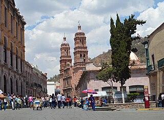
Zacatecas is the principal city within the municipality in Mexico of the same name, and the capital and the largest city of the state of Zacatecas. Located in north-central Mexico, the city had its start as a Spanish mining camp in the mid-16th century. Native Americans had already known about the area's rich deposits of silver and other minerals. Due to the wealth that the mines provided, Zacatecas quickly became one of the most important mining cities in New Spain. The area saw battles during the turbulent 19th century, but the next major event was the Battle of Zacatecas during the Mexican Revolution when Francisco Villa captured the town, an event still celebrated every anniversary. Today, the colonial part of the city is a World Heritage Site, due to the Baroque and other structures built during its mining days. Mining still remains an important industry. The name Zacatecas is derived from the Zacateco people and has its roots in Nahuatl. The name means "people of the grasslands".

<span class="mw-page-title-main">Comitán</span> Municipality and city in Chiapas

Comitán is the fourth-largest city in the Mexican state of Chiapas. It is the seat of government of the municipality of the same name.

<span class="mw-page-title-main">San Luis Potosí (city)</span> City in San Luis Potosí, Mexico

San Luis Potosí, commonly called SLP or simply San Luis, is the capital and the most populous city of the Mexican state of San Luis Potosí. It is the municipal seat of the surrounding municipality of San Luis Potosí. The city lies at an elevation of 1,864 metres. It has an estimated population of 824,229 in the city proper and a population of approximately 1,221,526 in its metropolitan area, formed with the neighbour city of Soledad de Graciano Sánchez and other surrounding municipalities, which makes the metropolitan area of Greater San Luis Potosí the eleventh largest in Mexico.

<span class="mw-page-title-main">Felipe Carrillo Puerto, Quintana Roo</span> Place in Quintana Roo, Mexico

Felipe Carrillo Puerto is the municipal seat and largest city in Felipe Carrillo Puerto Municipality in the Mexican state of Quintana Roo. According to the 2010 census, the city's population was 25,744 persons, mostly of Maya descent. The Sian Ka'an Biosphere Reserve lies just east of the city.

<span class="mw-page-title-main">El Fuerte, Sinaloa</span> Place in Sinaloa, Mexico

El Fuerte is a city and El Fuerte Municipality its surrounding municipality in the northwestern Mexican state of Sinaloa. The city population reported in the 2010 census was 12,566 people.

<span class="mw-page-title-main">Santa Rosalía, Baja California Sur</span> City in Baja California Sur, Mexico

Santa Rosalía is a city and municipal seat of Mulegé Municipality, in Baja California Sur, situated along the Gulf of California. Located on the east coast of the Baja Peninsula, the town had a population of 14,357 inhabitants in 2020. The city was founded as a company town by the French Compagnie du Boleo in 1884, which established the local copper mines. Today the city is a popular tourist destination.

<span class="mw-page-title-main">Rioverde, San Luis Potosí</span> City and Municipality in San Luis Potosí, Mexico

Rioverde is a city and its surrounding municipality located in the south-central part of the state of San Luis Potosí, Mexico. It is the fifth-most populated city in the state, behind San Luis Potosí, Soledad de Graciano Sánchez, Ciudad Valles, and Matehuala. It is the agricultural, economic, turistic and demographic most important core in the Zona Media, one of the four geographical divisions of the state. The city had a 2005 census population of 49,183, while the municipality, of which it serves as municipal seat, had a population of 85,945 and an area extent of 3,064 km². The population of its metropolitan area, which includes the largest municipality of Ciudad Fernández, was 126,997.

<span class="mw-page-title-main">Aldama Municipality, Tamaulipas</span>

Aldama is a municipality of the northeastern Mexican state of Tamaulipas. According to the census of 2010, the municipality had an area of 3,672 square kilometres (1,418 sq mi) and a population of 29,470, including the town of Aldama with a population of 13,661.

<span class="mw-page-title-main">Juan Aldama, Zacatecas</span>

Juan Aldama is a city in the northwestern portion of the Mexican state of Zacatecas. It is the biggest community in the Municipality of Juan Aldama and the seat of the municipal government.

<span class="mw-page-title-main">Jerez de García Salinas</span> City in Zacatecas, Mexico

Jerez is a town and municipality in the Mexican state of Zacatecas. To distinguish the two, the town is officially called Jerez de García Salinas reformer, in honor of a 19th-century reformer. The town of Jerez governs 128 other communities, which comprise a rural area known for its production of fruit trees and dairy. Jerez was designated a Pueblo Mágico to promote tourism, as it is in close proximity to the state capital of Zacatecas and offers handcrafts, traditional food, and architecture."

Tayahua is a small provincial town in the central Mexican state of Zacatecas. The town has less than 2,193 inhabitants. Tayahua is a municipality of the city Villanueva. It is located West of Villanueva and East of the City Tabasco. This town was once inhabited by the famous actor/singer Antonio Aguilar before he built his own ranch "El Soyate" approximately 30 km (19 mi) east of Tayahua off the main highway road. Antonio Aguilar and family once lived in La Hacienda by the Catholic Church in Tayahua.

<span class="mw-page-title-main">Sombrerete, Zacatecas</span> City & Municipality in Zacatecas, Mexico

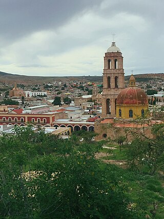
Sombrerete is a town and municipality located in the northwest of the Mexican state of Zacatecas, bordering the state of Durango.

<span class="mw-page-title-main">Calera de Víctor Rosales</span> Municipality in Zacatecas, Mexico

Calera is one of the 58 municipalities in the Mexican state of Zacatecas. It is located on the central part of the state of Zacatecas and it is bounded by the municipalities of General Enrique Estrada, Fresnillo, Villa de Cos, Pánuco, Morelos and Zacatecas. The municipality covers a total surface area of 389 square kilometers (150 sq mi). The municipality makes up for 0.5% of the area of the state of Zacatecas.

<span class="mw-page-title-main">Concepción del Oro Municipality</span> Municipality in Zacatecas, Mexico

Concepción del Oro is one of the 58 municipalities in the Mexican state of Zacatecas. It is located on the northern part of the state and it is bounded by the municipalities of Mazapil and El Salvador; it also lies next to the states of Coahuila and San Luis Potosí. The municipality covers a total surface area of 2,559 square kilometers (988 sq mi).

<span class="mw-page-title-main">Milpillas de Allende</span> Town in Zacatecas, México

Milpillas de Allende is a town in the southern portion of the Mexican state of Zacatecas, at around 21°19'31" N, 103°36'50" W, in the municipality of Teúl de González Ortega. People of this singular town grow corn and blue agave in peculiar red soil, and also engage in cattle ranching.

<span class="mw-page-title-main">General Francisco R. Murguía Municipality</span> Municipality in Zacatecas, Mexico

General Francisco R. Murguía is a municipality in the Mexican state of Zacatecas, located approximately 140 kilometres (87 mi) north of the state capital of Zacatecas City.

<span class="mw-page-title-main">Villa González Ortega</span> Municipality in Zacatecas, Mexico

Villa González Ortega is a municipality in the Mexican state of Zacatecas, located approximately 70 kilometres (43 mi) southeast of the state capital of Zacatecas City. It is named after Jesús González Ortega.

<span class="mw-page-title-main">Noria de Ángeles</span> Municipality in Zacatecas, Mexico

Noria de Ángeles is a municipality in the Mexican state of Zacatecas, located approximately 75 kilometres (47 mi) southeast of the state capital of Zacatecas City.

<span class="mw-page-title-main">Luis Moya, Zacatecas</span> Municipality in Zacatecas, Mexico

Luis Moya is a municipality in the Mexican state of Zacatecas, located approximately 50 kilometres (31 mi) southeast of the state capital of Zacatecas City. It is named after Luis Moya (1855–1911), a colonel in the Mexican Revolution who was posthumously given the rank of brigadier general in 1939.

Genaro Codina is a municipality in the Mexican state of Zacatecas, located approximately 30 kilometres (19 mi) southwest of the state capital of Zacatecas City. It is named after Genaro Codina, musician and composer of the state anthem, the March of Zacatecas.

References

  1. "Estado de Zacatecas-Estacion: Villanueva (DGE)". Normales Climatologicas 1951–2010 (in Spanish). Servicio Meteorológico Nacional. Retrieved 20 April 2015.
  2. "Extreme Temperatures and Precipitation for Villanueva (DGE) 1961–2011" (in Spanish). Servicio Meteorológico Nacional. Retrieved 20 April 2015.