Volcanic explosivity index

Last updated
VEI and ejecta volume correlation VEIfigure en.svg
VEI and ejecta volume correlation

The volcanic explosivity index (VEI) is a relative measure of the explosiveness of volcanic eruptions. It was devised by Christopher G. Newhall of the United States Geological Survey and Stephen Self in 1982.

Contents

Volume of products, eruption cloud height, and qualitative observations (using terms ranging from "gentle" to "mega-colossal") are used to determine the explosivity value. The scale is open-ended with the largest eruptions in history given a magnitude of 8. A value of 0 is given for non-explosive eruptions, defined as less than 10,000 m3 (350,000 cu ft) of tephra ejected; and 8 representing a mega-colossal explosive eruption that can eject 1.0×10¹² m3 (240 cubic miles) of tephra and have a cloud column height of over 20 km (66,000 ft). The scale is logarithmic, with each interval on the scale representing a tenfold increase in observed ejecta criteria, with the exception of between VEI-0, VEI-1 and VEI-2. [1]

Classification

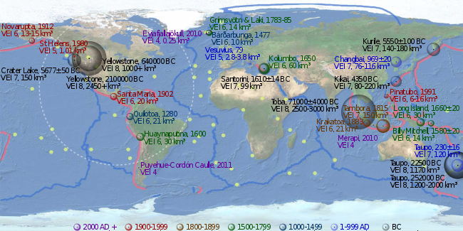
With indices running from 0 to 8, the VEI associated with an eruption is dependent on how much volcanic material is thrown out, to what height, and how long the eruption lasts. The scale is logarithmic from VEI-2 and up; an increase of 1 index indicates an eruption that is 10 times as powerful. As such, there is a discontinuity in the definition of the VEI between indices 1 and 2. The lower border of the volume of ejecta jumps by a factor of one hundred, from 10,000 to 1,000,000 m3 (350,000 to 35,310,000 cu ft), while the factor is ten between all higher indices. In the following table, the frequency of each VEI indicates the approximate frequency of new eruptions of that VEI or higher.

VEIEjecta
volume
(bulk)
ClassificationDescriptionPlumePeriodicityTropospheric
injection
Stratospheric
injection [2]
Examples
0< 104 m3 Hawaiian Effusive< 100 mconstantnegligiblenone
Kīlauea (current), Mawson Peak (current), Dallol (2011), Holuhraun (2014-2015), Fagradalsfjall (2021-2023), Mauna Loa (1975, 1984, 2022)
1 > 104 m3Hawaiian / Strombolian Gentle100 m – 1 kmdailyminornone
Yakedake (1995), Raoul Island (2006), Havre Seamount (2012), Dieng Volcanic Complex (1964, 1979, 2017), Nyiragongo (1977, 2002, 2021)
2 > 106 m3Strombolian / Vulcanian Explosive1–5 km2 weeksmoderatenone
Stromboli (since 1934), Etna (current), Unzen (1792), Ruang (1871), Ritter Island (1888), Galeras (1993), Whakaari / White Island (2019)
3 > 107 m3Strombolian / Vulcanian / Peléan / Sub-PlinianSevere3–15 km3 monthssubstantialpossible
Surtsey (1963-1967), Nevado del Ruiz (1985), Redoubt (1989-1990), Soufrière Hills (1997), Ontake (2014), Fuego (2018), Cumbre Vieja (2021)
4 > 0.1 km3Peléan / Plinian / Sub-PlinianCatastrophic> 10 km18 monthssubstantialdefinite
Laki (1783), Bandai (1888), Pelée (1902), Lamington (1951), Eyjafjallajökull (2010), Merapi (2010), Taal (2020), Semeru (2021)
5 > 1 km3Peléan / PlinianCataclysmic> 10 km12 yearssubstantialsignificant
Vesuvius (79), Fuji (1707), Tarawera (1886), St. Helens (1980), El Chichón (1982), Puyehue (2011), Hunga Tonga–Hunga Haʻapai (2022)
6 > 10 km3Plinian / Ultra-Plinian Colossal> 20 km50–100 yearssubstantialsubstantial
Santorini (1620 BC), Lake Ilopango (450), Huaynaputina (1600), Krakatoa (1883), Santa Maria (1902), Novarupta (1912), Pinatubo (1991)
7 > 100 km3Ultra-PlinianSuper-colossal> 20 km500–1,000 yearssubstantialsubstantial
Long Valley (760 kyr), Campi Flegrei (37 kyr), Aira (22 kyr), Mazama (5700 BC), Kikai (4300 BC), Samalas (1257), Tambora (1815)
8 > 1,000 km3Ultra-PlinianMega-colossal> 20 km> 50,000 years [3] [4] vastvast
Flat Landing Brook (Ordovician), Wah Wah Springs (30 Mya), La Garita (26.3 Mya), Yellowstone (2.1 Mya, 640 kyr), Toba (74 kyr), Taupō (26.5 kyr)

About 40 eruptions of VEI-8 magnitude within the last 132 million years (Mya) have been identified, of which 30 occurred in the past 36 million years. Considering the estimated frequency is on the order of once in 50,000 years, [3] there are likely many such eruptions in the last 132 Mya that are not yet known. Based on incomplete statistics, other authors assume that at least 60 VEI-8 eruptions have been identified. [5] [6] The most recent is Lake Taupō's Oruanui eruption, more than 27,000 years ago, which means that there have not been any Holocene eruptions with a VEI of 8. [5]

There have been at least 10 eruptions of VEI-7 in the last 11,700 years. There are also 58 Plinian eruptions, and 13 caldera-forming eruptions, of large, but unknown magnitudes. By 2010, the Global Volcanism Program of the Smithsonian Institution had cataloged the assignment of a VEI for 7,742 volcanic eruptions that occurred during the Holocene (the last 11,700 years) which account for about 75% of the total known eruptions during the Holocene. Of these 7,742 eruptions, about 49% have a VEI of 2 or lower, and 90% have a VEI of 3 or lower. [7]

Limitations

Under the VEI, ash, lava, lava bombs, and ignimbrite are all treated alike. Density and vesicularity (gas bubbling) of the volcanic products in question is not taken into account. In contrast, the DRE (dense-rock equivalent) is sometimes calculated to give the actual amount of magma erupted. Another weakness of the VEI is that it does not take into account the power output of an eruption, which makes the VEI extremely difficult to determine with prehistoric or unobserved eruptions.

Although VEI is quite suitable for classifying the explosive magnitude of eruptions, the index is not as significant as sulfur dioxide emissions in quantifying their atmospheric and climatic impact. [8]

Lists of notable eruptions

Clickable imagemap of notable volcanic eruptions. The apparent volume of each bubble is linearly proportional to the volume of tephra ejected, colour-coded by time of eruption as in the legend. Pink lines denote convergent boundaries, blue lines denote divergent boundaries and yellow spots denote hotspots. Volcanic eruption map.svg1912 eruption of NovaruptaYellowstone CalderaAD 79 Eruption of Mount Vesuvius1902 eruption of Santa María1280 eruption of Quilotoa1600 eruption of HuaynaputinaYellowstone Caldera1783 eruption of Laki1477 eruption of Bárðarbunga1650 eruption of KolumboVolcanic activity at Santorini1991 eruption of Mount PinatuboCrater Lake
Clickable imagemap of notable volcanic eruptions. The apparent volume of each bubble is linearly proportional to the volume of tephra ejected, colour-coded by time of eruption as in the legend. Pink lines denote convergent boundaries, blue lines denote divergent boundaries and yellow spots denote hotspots.

See also

Related Research Articles

<span class="mw-page-title-main">Supervolcano</span> Volcano that has erupted 1000 cubic km of lava in a single eruption

A supervolcano is a volcano that has had an eruption with a volcanic explosivity index (VEI) of 8, the largest recorded value on the index. This means the volume of deposits for such an eruption is greater than 1,000 cubic kilometers.

<span class="mw-page-title-main">Volcano</span> Rupture in a planets crust where material escapes

A volcano is a rupture in the crust of a planetary-mass object, such as Earth, that allows hot lava, volcanic ash, and gases to escape from a magma chamber below the surface.

<span class="mw-page-title-main">Hekla</span> Stratovolcano in South of Iceland

Hekla, or Hecla, is an active stratovolcano in the south of Iceland with a height of 1,491 m (4,892 ft). Hekla is one of Iceland's most active volcanoes; over 20 eruptions have occurred in and around the volcano since the year 1210. During the Middle Ages, the Icelandic Norse called the volcano the "Gateway to Hell" and the idea spread over much of Europe.

<span class="mw-page-title-main">Ring of Fire</span> Region around the rim of the Pacific Ocean where many volcanic eruptions and earthquakes occur

The Ring of Fire is a tectonic belt of volcanoes and earthquakes.

<span class="mw-page-title-main">Volcanism of Iceland</span>

Iceland experiences frequent volcanic activity, due to its location both on the Mid-Atlantic Ridge, a divergent tectonic plate boundary, and being over a hotspot. Nearly thirty volcanoes are known to have erupted in the Holocene epoch; these include Eldgjá, source of the largest lava eruption in human history. Some of the various eruptions of lava, gas and ash have been both destructive of property and deadly to life over the years, as well as disruptive to local and European air travel.

<span class="mw-page-title-main">Snæfellsjökull</span> Stratovolcano in Iceland

Snæfellsjökull is a 700,000-year-old glacier-capped stratovolcano in western Iceland. It is situated on the westernmost part of the Snæfellsnes peninsula. Sometimes it may be seen from the city of Reykjavík over Faxa Bay, at a distance of 120 km (75 mi).

<span class="mw-page-title-main">Grímsvötn</span> Volcano in Iceland

Grímsvötn is an active volcano with a fissure system located in Vatnajökull National Park, Iceland. The volcano itself is completely subglacial and located under the northwestern side of the Vatnajökull ice cap. The subglacial caldera is at 64°25′N17°20′W, at an elevation of 1,725 m (5,659 ft). Beneath the caldera is the magma chamber of the Grímsvötn volcano.

<span class="mw-page-title-main">Cerro Negro</span> Active volcano in Nicaragua

Cerro Negro is an active volcano in the Cordillera de los Maribios mountain range in Nicaragua, about 10 km (6.2 mi) from the village of Malpaisillo. It is a very new volcano, the youngest in Central America, having first appeared in April 1850. It consists of a gravelly basaltic cinder cone, which contrasts greatly with the surrounding verdant hillsides, and gives rise to its name, which means Black Hill. Cerro Negro has erupted frequently since its first eruption. One unusual aspect of several eruptions has been the emission of ash from the top of the cone, while lava erupts from fractures at the base.

<span class="mw-page-title-main">Cerro Azul (Chile volcano)</span> Mountain in Curicó Province, Chile

Cerro Azul, sometimes referred to as Quizapu, is an active stratovolcano in the Maule Region of central Chile, immediately south of Descabezado Grande. Part of the South Volcanic Zone of the Andes, its summit is 3,788 meters (12,428 ft) above sea level, and is capped by a summit crater that is 500 meters (1,600 ft) wide and opens to the north. Beneath the summit, the volcano features numerous scoria cones and flank vents.

<span class="mw-page-title-main">Strombolian eruption</span> Type of volcanic eruption with relatively mild explosive intensity

In volcanology, a Strombolian eruption is a type of volcanic eruption with relatively mild blasts, typically having a Volcanic Explosivity Index of 1 or 2. Strombolian eruptions consist of ejection of incandescent cinders, lapilli, and volcanic bombs, to altitudes of tens to a few hundreds of metres. The eruptions are small to medium in volume, with sporadic violence. This type of eruption is named for the Italian volcano Stromboli.

<span class="mw-page-title-main">Nemo Peak</span>

Nemo Peak is a stratovolcano located at the northern end of Onekotan Island, Kuril Islands, Russia. It is truncated by two nested calderas, with the cone of Nemo Peak itself rising in the southwest end of the youngest caldera and a crater lake partially filling the northeast part, named Ozero Chernoye.

<span class="mw-page-title-main">Lake Ilopango</span> Crater lake in El Salvador which fills a caldera

Lake Ilopango is a crater lake which fills an 8 by 11 km volcanic caldera in central El Salvador, on the borders of the San Salvador, La Paz, and Cuscatlán departments. The caldera, which contains the second largest lake in the country and is immediately east of the capital city, San Salvador, has a scalloped 100 m (330 ft) to 500 m (1,600 ft) high rim. Any surplus drains via the Jiboa River to the Pacific Ocean. The local military airbase, Ilopango International Airport, has annual airshows where international pilots from all over the world fly over San Salvador City and Ilopango lake.

<span class="mw-page-title-main">Types of volcanic eruptions</span> Overview of different types of volcanic eruptions

Several types of volcanic eruptions—during which material is expelled from a volcanic vent or fissure—have been distinguished by volcanologists. These are often named after famous volcanoes where that type of behavior has been observed. Some volcanoes may exhibit only one characteristic type of eruption during a period of activity, while others may display an entire sequence of types all in one eruptive series.

Mentolat is an ice-filled, 6 km (4 mi) wide caldera in the central portion of Magdalena Island, Aisén Province, Chilean Patagonia. This caldera sits on top of a stratovolcano which has generated lava flows and pyroclastic flows. The caldera is filled with a glacier.

<span class="mw-page-title-main">Timeline of volcanism on Earth</span>

This timeline of volcanism on Earth includes a list of major volcanic eruptions of approximately at least magnitude 6 on the Volcanic explosivity index (VEI) or equivalent sulfur dioxide emission during the Quaternary period. Other volcanic eruptions are also listed.

<span class="mw-page-title-main">Bridge River Vent</span>

The Bridge River Vent is a volcanic crater in the Pacific Ranges of the Coast Mountains in southwestern British Columbia, Canada. It is located 51 km (32 mi) west of Bralorne on the northeastern flank of the Mount Meager massif. With an elevation of 1,524 m (5,000 ft), it lies on the steep northern face of Plinth Peak, a 2,677 m (8,783 ft) high volcanic peak comprising the northern portion of Meager. The vent rises above the western shoulder of the Pemberton Valley and represents the northernmost volcanic feature of the Mount Meager massif.

<span class="mw-page-title-main">Tierra Blanca Joven eruption</span> Catastrophic volcanic eruption of Lake Ilopango in El Salvador

The Tierra Blanca Joven eruption of Lake Ilopango was the largest volcanic eruption in El Salvador during historic times, and one of the largest volcanic events on Earth in the past 7,000 years, registering at 6 on the Volcanic explosivity index (VEI), and dating back to the mid 5th century A.D. The eruption produced between 37–82 km3 (8.9–19.7 cu mi) of ejecta. The date of the eruption has been constrained within 429–433 CE by identifying its signature volcanic ash in precision-dated ice cores sampled from Greenland, thus eliminating it as the cause of extreme weather events of 535–536.

<span class="mw-page-title-main">Cascade Volcanic Arc calderas</span>

The Cascade Volcanic Arc is a chain of volcanoes stretching from southern British Columbia down to northern California. Within the arc there is a variety of stratovolcanoes like Mount Rainier and broad shield volcanoes like Medicine Lake. But calderas are very rare in the Cascades, with very few forming over the 39 million year lifespan of the arc.

References

  1. Newhall, Christopher G.; Self, Stephen (1982). "The Volcanic Explosivity Index (VEI): An Estimate of Explosive Magnitude for Historical Volcanism" (PDF). Journal of Geophysical Research . 87 (C2): 1231–1238. Bibcode:1982JGR....87.1231N. doi:10.1029/JC087iC02p01231. Archived from the original (PDF) on December 13, 2013.
  2. "Volcanic Explosivity Index (VEI)". Global Volcanism Program. Smithsonian National Museum of Natural History. Archived from the original on November 10, 2011. Retrieved August 21, 2014.
  3. 1 2 Dosseto, A. (2011). Turner, S. P.; Van-Orman, J. A. (eds.). Timescales of Magmatic Processes: From Core to Atmosphere. Wiley-Blackwell. ISBN   978-1-4443-3260-5.
  4. Rothery, David A. (2010), Volcanoes, Earthquakes and Tsunamis, Teach Yourself
  5. 1 2 Mason, Ben G.; Pyle, David M.; Oppenheimer, Clive (2004). "The size and frequency of the largest explosive eruptions on Earth". Bulletin of Volcanology . 66 (8): 735–748. Bibcode:2004BVol...66..735M. doi:10.1007/s00445-004-0355-9. S2CID   129680497.
  6. Bryan, S.E. (2010). "The largest volcanic eruptions on Earth" (PDF). Earth-Science Reviews. 102 (3–4): 207–229. Bibcode:2010ESRv..102..207B. doi:10.1016/j.earscirev.2010.07.001.
  7. Siebert, L.; Simkin, T.; Kimberly, P. (2010). Volcanoes of the World (3rd ed.). University of California Press. pp. 28–38. ISBN   978-0-520-26877-7.
  8. Miles, M. G.; Grainger, R. G.; Highwood, E. J. (2004). "Volcanic Aerosols: The significance of volcanic eruption strength and frequency for climate" (PDF). Quarterly Journal of the Royal Meteorological Society . 130 (602): 2361–2376. Bibcode:2004QJRMS.130.2361M. doi:10.1256/qj.03.60. S2CID   53005926.