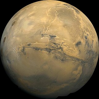
Valles Marineris is a system of canyons that runs along the Martian surface east of the Tharsis region. At more than 4,000 km (2,500 mi) long, 200 km (120 mi) wide and up to 7 km (23,000 ft) deep, Valles Marineris is the largest canyon in the Solar System.

The Mono–Inyo Craters are a volcanic chain of craters, domes and lava flows in Mono County, Eastern California. The chain stretches 25 miles (40 km) from the northwest shore of Mono Lake to the south of Mammoth Mountain. The Mono Lake Volcanic Field forms the northernmost part of the chain and consists of two volcanic islands in the lake and one cinder cone volcano on its northwest shore. Most of the Mono Craters, which make up the bulk of the northern part of the Mono–Inyo chain, are phreatic volcanoes that have since been either plugged or over-topped by rhyolite domes and lava flows. The Inyo volcanic chain form much of the southern part of the chain and consist of phreatic explosion pits, and rhyolitic lava flows and domes. The southernmost part of the chain consists of fumaroles and explosion pits on Mammoth Mountain and a set of cinder cones south of the mountain; the latter are called the Red Cones.
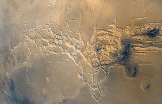
Noctis Labyrinthus is a region of Mars located in the Phoenicis Lacus quadrangle, between Valles Marineris and the Tharsis upland. The region is notable for its maze-like system of deep, steep-walled valleys. The valleys and canyons of this region formed by faulting and many show classic features of grabens, with the upland plain surface preserved on the valley floor. In some places the valley floors are rougher, disturbed by landslides, and there are places where the land appears to have sunk down into pit-like formations. It is thought that this faulting was triggered by volcanic activity in the Tharsis region. Research described in December 2009 found a variety of minerals, including clays, sulfates, and hydrated silicas, in some of the layers.

Ascraeus Mons is a large shield volcano located in the Tharsis region of the planet Mars. It is the northernmost and tallest of three shield volcanoes collectively known as the Tharsis Montes.

The geology of Mercury is the scientific study of the surface, crust, and interior of the planet Mercury. It emphasizes the composition, structure, history, and physical processes that shape the planet. It is analogous to the field of terrestrial geology. In planetary science, the term geology is used in its broadest sense to mean the study of the solid parts of planets and moons. The term incorporates aspects of geophysics, geochemistry, mineralogy, geodesy, and cartography.

Tempe Terra is a heavily cratered highland region in the northern hemisphere of the planet Mars. Located at the northeastern edge of the Tharsis volcanic province, Tempe Terra is notable for its high degree of crustal fracturing and deformation. The region also contains many small shield volcanoes, lava flows, and other volcanic structures.

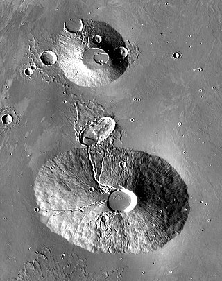
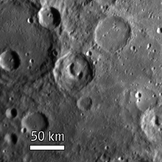
A pit crater is a depression formed by a sinking or collapse of the surface lying above a void or empty chamber, rather than by the eruption of a volcano or lava vent. Pit craters are found on Mercury, Venus, Earth, Mars, and the Moon. Pit craters are often found in a series of aligned or offset chains and in these cases, the features is called a pit crater chain. Pit crater chains are distinguished from catenae or crater chains by their origin. When adjoining walls between pits in a pit crater chain collapse, they become troughs. In these cases, the craters may merge into a linear alignment and are commonly found along extensional structures such as fractures, fissures and graben. Pit craters usually lack an elevated rim as well as the ejecta deposits and lava flows that are associated with impact craters. Pit craters are characterized by vertical walls that are often full of fissures and vents. They usually have nearly circular openings.

Tharsis Tholus is an intermediate-sized shield volcano located in the eastern Tharsis region of the planet Mars. The volcano was discovered by the Mariner 9 spacecraft in 1972 and originally given the informal name Volcano 7. In 1973, the International Astronomical Union (IAU) officially designated it Tharsis Tholus. In planetary geology, tholus is the term for a small domical mountain, usually a volcano.

The Phoenicis Lacus quadrangle is one of a series of 30 quadrangle maps of Mars used by the United States Geological Survey (USGS) Astrogeology Research Program. The Phoenicis Lacus quadrangle is also referred to as MC-17. Parts of Daedalia Planum, Sinai Planum, and Solis Planum are found in this quadrangle. Phoenicis Lacus is named after the phoenix which according to myth burns itself up every 500 years and then is reborn.
Ceraunius Tholus is a volcano on Mars located in the Tharsis quadrangle at 24.25° north latitude and 262.75° east longitude, part of the Uranius group of volcanoes. It is 130 kilometres (81 mi) across, approximately 8,500 metres (27,887 ft) high and is named after a classical albedo feature name.

Tyrrhenus Mons, formerly Tyrrhena Mons or Tyrrhena Patera, is a large volcano in the Mare Tyrrhenum quadrangle of Mars, located at 21.36° south latitude and 253.47° west longitude. The name "Tyrrhena Patera" now refers only to the central depression, a volcanic crater or caldera. It was named after a classical albedo feature name. Pit chains are found at the summit of Tyrrhenus Mons. They are formed by collapse of material into underground voids. Since they form chains and concentric fractures that are aligned, they are probably caused by extension of the surface. Volcanic processes made the crust pull apart. Voids were formed, then material fell into them, leaving holes. It is one of the oldest volcanoes on Mars. As a consequence of its old age, Tyrrhenus Mons has many radiating gullies on its slope. When it was formed, magma may have gone through frozen ground and then erupted as easily eroded ash, instead of lava flows.
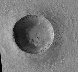
Zumba is a very young crater on Mars, located in the Phoenicis Lacus quadrangle at 28.68 South and 133.18 West. It measures approximately 2.93 kilometres (1.82 mi) in diameter and was named after the town of Zumba in Ecuador. The name was adopted by IAU's Working Group for Planetary System Nomenclature in 2006.

Gibran is a crater on Mercury and is in the east of the Shakespeare quadrangle. It was named after Lebanese-American poet Khalil Gibran in 2009. Gibran is located east of the rayed crater of Degas and nearby Damer.
Beckett is a pit-floored crater on Mercury, which was discovered in January 2008 during the first flyby of the planet by the MESSENGER spacecraft. The crater was named in November 2008 by the IAU.

Glinka is a pit-floored crater on Mercury, which was discovered in 1974 by Mariner 10 spacecraft. It was named by the IAU in 2008, after Russian composer Mikhail Glinka.

Scarlatti is a pit-floored crater on Mercury, which was discovered in 1974 by the Mariner 10 spacecraft. It has a prominent peak ring, and it is one of 110 peak ring basins on Mercury. The crater floor is covered by the smooth plains material. The crater displays an arcuate collapse feature along the northeastern peak ring. The size of the pit, which was first noticed in MESSENGER images obtained in January 2008, is 38 × 12 km. Such a feature may have resulted from collapse of a magma chamber underlying the central peak ring complex of the crater. The collapse feature is an analog of Earth's volcanic calderas. Scarlatti is thought to have the same age as the Caloris basin.

To Ngoc Van is a pit-floored crater on Mercury, named after the Vietnamese artist Tô Ngọc Vân. It was discovered in January 2008 during the first flyby of the planet by MESSENGER spacecraft. Its floor displays an irregularly shaped collapse feature, which is called a central pit. The size of the pit is 21 × 10 km. Such a feature may have resulted from collapse of a magma chamber underlying the central part of the crater. The collapse feature is an analog of Earth's volcanic calderas.

Hadley–Apennine is a region on the near side of Earth's Moon that served as the landing site for the American Apollo 15 mission, the fourth crewed landing on the Moon and the first of the "J-missions", in July 1971. The site is located on the eastern edge of Mare Imbrium on a lava plain known as Palus Putredinis. Hadley–Apennine is bordered by the Montes Apenninus, a mountain range, and Hadley Rille, a meandering channel, on the east and west, respectively.
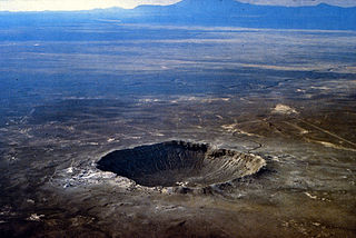
A crater is a landform consisting of a hole or depression on a planetary surface, usually caused either by an object hitting the surface, or by geological activity on the planet. A crater has classically been described as: "a bowl-shaped pit that is formed by a volcano, an explosion, or a meteorite impact". On Earth, craters are "generally the result of volcanic eruptions", while "meteorite impact craters are common on the Moon, but are rare on Earth".

A volcanic crater lake is a lake in a crater that was formed by explosive activity or a collapse during a volcanic eruption.
