Washington, West Virginia

Last updated
Washington, West Virginia
CDP
WVMap-doton-Washington.PNG
Location of Washington, West Virginia
Coordinates: 39°14′52″N81°39′54″W / 39.24778°N 81.66500°W / 39.24778; -81.66500
Country United States
State West Virginia
County Wood
Area
[1]
  Total4.4 sq mi (11.3 km2)
  Land4.2 sq mi (10.8 km2)
  Water0.2 sq mi (0.6 km2)
Elevation
[2]
640 ft (200 m)
Population
 (2010) [3]
  Total1,175
  Density270/sq mi (100/km2)
Time zone UTC-5 (Eastern (EST))
  Summer (DST) UTC-4 (EDT)
ZIP code
26181
Area code 304
FIPS code 54-84724 [4]
GNIS feature ID2390456 [2]

Washington is a census-designated place (CDP) in Wood County, West Virginia, United States, situated along the Ohio River. It is part of the Parkersburg-Marietta-Vienna, WV-OH Metropolitan Statistical Area. The population was 1,175 at the 2010 census. [3] The community was named after George Washington. [5]

Contents

The CDP is home to the Washington Works, one of the largest single facilities of chemicals manufacturing giant Chemours.

Also home to Sabic Plastics Washington Works (previously GE Plastics, acquired from Borg Warner Plastics, née Marbon), Kuraray Washington Works, Dupont Washington Works and a Linde air separation plant. Dupont polluted Washington with Perfluorooctanoic acid or PFOA, which it used to make Teflon.

Geography

According to the United States Census Bureau, the CDP has a total area of 4.4 square miles (11.3 km2), of which 4.2 square miles (10.8 km2) is land and 0.2 square mile (0.6 km2) (5.13%) is water.

Demographics

Washington, WV, post office. Washington, WV, post office..JPG
Washington, WV, post office.

As of the census [4] of 2000, there were 1,170 people, 466 households, and 376 families residing in the community. The population density was 275.6 people per square mile (106.3/km2). There were 518 housing units at an average density of 122.0/sq mi (47.1/km2). The racial makeup of the community was 98.21% White, 0.17% African American, 0.60% Native American, 0.43% Asian, and 0.60% from two or more races.

There were 466 households, out of which 32.8% had children under the age of 18 living with them, 73.0% were married couples living together, 4.9% had a female householder with no husband present, and 19.1% were non-families. 16.7% of all households were made up of individuals, and 4.9% had someone living alone who was 65 years of age or older. The average household size was 2.51 and the average family size was 2.81.

The age distribution is 23.6% under the age of 18, 4.7% from 18 to 24, 26.8% from 25 to 44, 33.8% from 45 to 64, and 11.2% who were 65 years of age or older. The median age was 42 years. For every 100 females, there were 106.3 males. For every 100 females age 18 and over, there were 100.0 males.

The median income for a household in the community was $54,483, and the median income for a community is $60,000. Males had a median income of $48,036 versus $24,712 for females. The per capita income for the CDP was $25,209. About 2.1% of families and 2.3% of the population were below the poverty line, including 3.4% of those under age 18 and 5.1% of those age 65 or over.

Washington marker in Washington, West Virginia. Washington marker in Washington, West Virginia..JPG
Washington marker in Washington, West Virginia.

History

A commemorative marker located near the Washington, WV, post office reads;

"George Washington acquired 2,314 acres of this land in Washington Bottom by a grant, dated December 15, 1772, issued to him by John Murray, Earl of Dunmore, last Royal Governor of Virginia. Washington obtained this tract for services in the French and Indian War, upon a survey made by William Crawford, in June 1771. It borders on the Ohio River five miles and one hundred and twenty poles. Erected by the State of West Virginia 1932"

See also

Related Research Articles

<span class="mw-page-title-main">Park Layne, Ohio</span> Census-designated place in Ohio, United States

Park Layne is a census-designated place (CDP) in Bethel Township, Clark County, Ohio, United States. The population of the CDP was 4,248 at the 2020 census. It is part of the Springfield, Ohio Metropolitan Statistical Area. Park Layne became a CDP in the 1980 United States Census.

<span class="mw-page-title-main">North Fork Village, Ohio</span> Former CDP in Ohio, United States

North Fork Village is an unincorporated community and former census-designated place (CDP) in Ross County, Ohio, United States. The population was 1,726 at the 2000 census. It was not delineated as a CDP for the 2010 census.

<span class="mw-page-title-main">Devola, Ohio</span> CDP in Ohio, United States

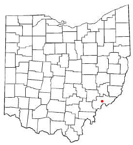
Devola is a census-designated place (CDP) in Washington County, Ohio, United States, along the Muskingum River. It is part of the Parkersburg-Marietta-Vienna, WV-OH Metropolitan Statistical Area. The population was 2,639 at the 2020 census.

<span class="mw-page-title-main">Powellton, West Virginia</span> CDP in West Virginia, United States

Powellton is a census-designated place (CDP) in Fayette County, West Virginia, United States. The population was 619 at the 2010 census.

<span class="mw-page-title-main">Pinch, West Virginia</span> Census-designated place in West Virginia, United States

Pinch is a census-designated place (CDP) in Kanawha County, West Virginia, United States. The population was 3,262 at the 2010 census.

<span class="mw-page-title-main">Alum Creek, West Virginia</span> Census-designated place in West Virginia, United States

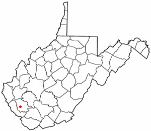
Alum Creek is a census-designated place (CDP) in Kanawha and Lincoln counties along the Coal River in the U.S. state of West Virginia. It includes the unincorporated communities of Alum Creek, Forks of Coal, and Priestley. The CDP had a population of 1,749 at the 2010 census, down from 1,839 at the 2000 census.

<span class="mw-page-title-main">Mallory, West Virginia</span> Census-designated place in West Virginia, United States

Mallory is a census-designated place (CDP) in Logan County, West Virginia, United States. The population was 1,654 at the 2010 census. The CDP contains the unincorporated communities, from west to east, of Huff Junction, Mallory, Davin, Mineral City, Claypool, Combs Addition, and Gillman Bottom.

<span class="mw-page-title-main">Switzer, West Virginia</span> Census-designated place in West Virginia, United States

Switzer is an unincorporated community and census-designated place (CDP) in Logan County, West Virginia, United States. The CDP includes the neighboring unincorporated community of Micco. The total CDP population was 595 at the 2010 census.

<span class="mw-page-title-main">Wiley Ford, West Virginia</span> CDP in West Virginia, United States

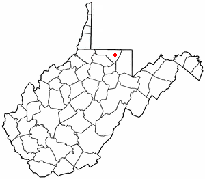
Wiley Ford is a census-designated place (CDP) in Mineral County, West Virginia, United States and part of the 'Cumberland, MD-WV Metropolitan Statistical Area'. The population was 1,026 at the 2010 census.

<span class="mw-page-title-main">Chattaroy, West Virginia</span> Census-designated place in West Virginia, United States

Chattaroy is a census-designated place (CDP) in Mingo County, West Virginia, United States. The population was 756 at the 2010 census.

<span class="mw-page-title-main">Brookhaven, West Virginia</span> CDP in West Virginia

Brookhaven is a census-designated place (CDP) in Monongalia County, West Virginia, United States. The population was 5,707 at the 2020 census. It is included in the Morgantown, West Virginia Metropolitan Statistical Area.

<span class="mw-page-title-main">Coal City, West Virginia</span> Census-designated place in West Virginia, United States

Coal City is a census-designated place (CDP) in Raleigh County, West Virginia, United States. The population was 1,815 at the 2010 census. Coal City's population is composed of other surrounding unincorporated communities.

<span class="mw-page-title-main">Shady Spring, West Virginia</span> Census-designated place in West Virginia, United States

Shady Spring is a census-designated place (CDP) in Raleigh County, West Virginia, United States. The population was 2,998 at the 2010 census. It is a residential community, with a low crime rate.

<span class="mw-page-title-main">Stanaford, West Virginia</span> Census-designated place in West Virginia, United States

Stanaford is a census-designated place (CDP) and coal town in Raleigh County, West Virginia, United States. The population was 1,350 at the 2010 census.

<span class="mw-page-title-main">Blennerhassett, West Virginia</span> CDP in West Virginia, United States

Blennerhassett is a census-designated place (CDP) in Wood County, West Virginia, United States. It is part of the Parkersburg-Marietta-Vienna, WV-OH Metropolitan Statistical Area. The population was 3,089 at the 2010 census.

<span class="mw-page-title-main">Boaz, West Virginia</span> CDP in West Virginia, United States

Boaz is a census-designated place (CDP) in Wood County, West Virginia, United States. It is part of the Parkersburg-Marietta-Vienna, WV-OH Metropolitan Statistical Area. As of the 2020 census, the CDP population was 1,321.

<span class="mw-page-title-main">Lubeck, West Virginia</span> CDP in West Virginia, United States

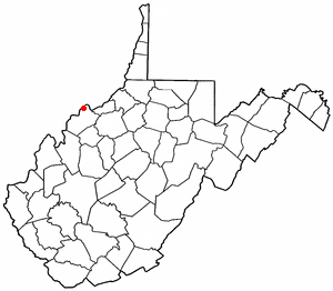
Lubeck is a census-designated place (CDP) in Wood County, West Virginia, United States. It is part of the Parkersburg-Marietta-Vienna, WV-OH Metropolitan Statistical Area. The population was 1,311 at the 2010 census. Though first named Watertown, postmaster Theodore Frederick Henry Slevogt in 1856 changed the name to Lubeck after his hometown in Germany.

<span class="mw-page-title-main">Mineralwells, West Virginia</span> CDP in West Virginia, United States

Mineralwells, also known as Mineral Wells, is a census-designated place (CDP) in Wood County, West Virginia, United States. It is part of the Parkersburg-Marietta-Vienna, WV-OH Metropolitan Statistical Area. The population was 1,950 at the 2010 census. The population was 2216 at the 2021 census.

<span class="mw-page-title-main">Loveland Park, Ohio</span> Census-designated place in Ohio, United States

Loveland Park is a census-designated place (CDP) located in Symmes Township, Hamilton County and Deerfield Township, Warren County, in the southwestern part of the U.S. state of Ohio. The CDP is named after the city of Loveland. The population was 1,737 at the 2020 census.

<span class="mw-page-title-main">Culloden, West Virginia</span> Census-designated place in West Virginia, United States

Culloden is a census-designated place in Cabell and Putnam counties in the U.S. state of West Virginia. As of the 2020 census, the population was 3,016. It is part of the Huntington–Ashland metropolitan area.

References

  1. "US Gazetteer files: 2010, 2000, and 1990". United States Census Bureau. 2011-02-12. Retrieved 2011-04-23.
  2. 1 2 U.S. Geological Survey Geographic Names Information System: Washington, West Virginia
  3. 1 2 "U.S. Census website". United States Census Bureau . Retrieved 2011-05-14.
  4. 1 2 "U.S. Census website". United States Census Bureau . Retrieved 2008-01-31.
  5. Kenny, Hamill (1945). West Virginia Place Names: Their Origin and Meaning, Including the Nomenclature of the Streams and Mountains. Piedmont, WV: The Place Name Press. p. 659.