
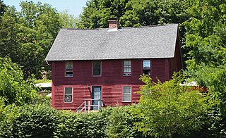
Gales Ferry is a village in the town of Ledyard, Connecticut, United States. It is located along the eastern bank of the Thames River. The village developed as a result of having a ferry to Uncasville located at this site, and from which the village was named. Gales Ferry was listed as a census-designated place for the 2010 Census, with a population of 1,162.

The Colchester Village Historic District encompasses most of the historic village center of Colchester, Connecticut. It is located at the junction of Route 16, Route 85, and Norwich Avenue. Roughly, the district extends to the northwest along Broadway Street as far as Jaffe Terrace; east along Norwich Avenue to just short of Pleasant Street; south along South Main Street to just north of Hall Hill Road; west along Linwood Avenue to just east of Kmick Lane. The historic district was listed on the National Register of Historic Places (NRHP) in 1994.
The Quaker Hill Historic District encompasses the center a mainly residential village in northeastern Waterford, Connecticut. Running in a mostly linear fashion along Old Norwich Road between Connecticut Route 32 and Richard Grove Road, the area first grew as a settlement of religious non-conformists in the 17th century, developed in the 19th century as a small industrial village, and became more suburban in character in the 20th century. Its architecture is reflective of these changes, and it was listed on the National Register of Historic Places in 2002.

The Quaker Farms Historic District is a historic district in the town of Oxford, Connecticut. It encompasses a small rural village on Quaker Farms Road anchored by the Christ Church Episcopal, an 1812 wood-frame church with Federal and Gothic styling, located at 470 Quaker Farms Road. The district also includes eleven houses, built between the mid-18th and mid-19th centuries. The oldest houses date to the 1720s, and the church has a particularly well-preserved early 19th-century interior, albeit with some alterations. One house was built about 1800 as a carriage manufactory. The district was listed on the National Register of Historic Places in 1991.

The Hotchkissville Historic District is a historic district in the town of Hotchkissville, Connecticut adjacent to Woodbury, Connecticut that was listed on the National Register of Historic Places in 1995. It encompasses most of the historic village of Hotchkissville, which is centered at the junction of Washington and Weekeepeemee Roads. The village began as a dispersed rural agricultural community, but developed in the 19th century with the arrival of industry, primarily the manufacture of textiles. Despite this, the village has retained a significantly rural character, and includes a broad cross-section of 18th- and 19th-century architectural styles. Notable residents include the Wols family.

The Hadley Center Historic District is an expansive, 2,500-acre (1,000 ha) historic district encompassing the village center of Hadley, Massachusetts. When it was first listed on the National Register of Historic Places in 1977, the district encompassed the town green and 17 buildings that faced it, at the junction of Russell Street and Middle Street. The district was expanded significantly in 1994, adding more than 400 buildings representative of the village's growth from colonial days into the first decades of the 20th century. This expansion encompasses the entirety of a tongue of land extending west from East Street and bounded by a bend in the Connecticut River, which separates Hadley from Northampton. Its oldest property, the Samuel Porter House on West Street, was built in 1713.

The Norwich Village Historic District encompasses the compact village center of Norwich, Vermont. The village was developed mainly in the first half of the 19th century, benefiting in importance from the 1820 founding of what is now Norwich University. The district has well-preserved examples of architecture ranging from the late 18th century to the early 20th century. It was listed on the National Register of Historic Places in 1991.

The New Preston Hill Historic District encompasses a small rural 19th-century village center in the New Preston area of the town of Washington, in Litchfield County, Connecticut. Settled in the late 18th century, it is distinctive for its examples of stone architecture, include a rare Federal period stone church. The district, located at the junction of New Preston Road with Gunn Hill and Findlay Roads, was listed on the National Register of Historic Places in 1985.
The Mansfield Center Historic District encompasses the historic early village center of Mansfield, Connecticut. First settled about 1692, it is one of the oldest settlements in Tolland County, and retains a strong sense of 18th century colonial layout. It extends along Storrs Street extending from Chaffeeville Road in the north to Centre Street in the south, and was listed on the National Register of Historic Places in 1972.

Roxbury Center is the central village of Roxbury, Connecticut. Centered at the junction of Connecticut Routes 67 and 317, it has been the center of town civic life since the mid-18th century. The village was listed on the National Register of Historic Places in 1983.
The Plymouth Center Historic District encompasses historic early village center of Plymouth, Connecticut. Stretching along Main, North and South Streets from their junction, it flourished in the 19th century with small-scale industries, but declined late in the century with the separation of Thomaston and the more significant industrial development at Terryville. The district features colonial, Federal, and Greek Revival architecture and was added to the National Register of Historic Places in 1999, with a slight enlargement the following year.
Bridgewater Center Historic District encompasses the traditional town center of Bridgewater, Connecticut. Centered at the junction of Main Street with Clapboard and Hat Shop Hill Roads, it developed in the early 19th century as a civic center, even before the town's 1856 incorporation from New Milford. The architecture of the center is largely reflective of the first half of the 19th century, including Greek Revival and Federal style buildings. It was listed on the National Register of Historic Places in 2000.

The Strafford Village Historic District encompasses the historic village center of Strafford, Vermont, United States. Founded in 1768, the village center was developed in the 1790s, and saw most of its growth before 1840, resulting in a fine assortment of predominantly Greek Revival buildings. Notable exceptions include the 1799 meetinghouse, and the Justin Smith Morrill Homestead, a fine example of Gothic Revival architecture built by native son Justin Smith Morrill. The district, centered on the town green at the junction of Morrill Highway and Brook Road, was listed on the National Register of Historic Places in 1974.

The Weston Village Historic District encompasses the town center and principal village of Weston, Vermont. Centered on Farrar Park, which serves as the town green, it includes a diversity of architectural styles from the late 18th century to about 1935, and includes residential, civic, commercial, industrial and religious buildings. It was listed on the National Register of Historic Places in 1985.

The Thetford Hill Historic District encompasses the well-preserved 19th-century village center of Thetford Hill in Thetford, Vermont. Developed between 1792 and about 1860 and located at what is now the junction of Vermont Route 113 and Academy Road, it includes mainly residential buildings, as well as several buildings of Thetford Academy and the 1785-88 Thetford Meetinghouse, one of the state's oldest churches in continuous use. The district was listed on the National Register of Historic Places in 1988.

The Litchfield–South Roads Historic District encompasses part of the traditional town center of Harwinton, Connecticut. Settled in the second quarter of the 18th century, and centered at the junction of Connecticut Route 4 with North and South Roads, the town center includes a variety of mainly 19th century residential architecture, several churches, and municipal buildings. It was listed on the National Register of Historic Places in 1996.

The Watertown Center Historic District encompasses the historic village center of Watertown, Connecticut. It exhibits architectural and historic changes from the early 1700s into the 20th century. It is roughly bounded by Main, Warren, North, Woodbury, Woodruff, and Academy Hill Roads, and was listed on the National Register of Historic Places in 2001.

The Palisado Avenue Historic District encompasses a predominantly residential streetscape in northeastern Windsor, Connecticut. Extending along Palisado Avenue between the Farmington River and Bissell Ferry Road, it is a basically 18th-century street view, populated mainly with houses from the 18th to the 20th centuries. The district was listed on the National Register of Historic Places in 1987.

The Union Village Historic District encompasses the core of a historic 19th-century residential mill village in Manchester, Connecticut. Radiating north and west from the junction of Union Street and North Main Street, the area was developed in the first half of the 19th century has a company town, but evolved into a mixed working-class community in the 20th century. It was listed on the National Register of Historic Places in 2002.

The North Branford Center Historic District encompasses the historic town center of North Branford, Connecticut. Centered at the junction of North Street and Foxon Road, it has been the center of the town's civic and religious life since the early 18th century. The district includes the town hall, library, Congregational Church, and residential architecture dating to the early days. The district was listed on the National Register of Historic Places in 1999.


