Washington Park | |
---|---|
Coordinates: 38°37′47″N90°5′41″W / 38.62972°N 90.09472°W | |
Country | United States |
State | Illinois |
County | St. Clair |
Founded | December 19, 1923 [1] |
Area | |
• Total | 2.55 sq mi (6.61 km2) |
• Land | 2.55 sq mi (6.61 km2) |
• Water | 0.00 sq mi (0.00 km2) |
Elevation | 423 ft (129 m) |
Population (2020) | |
• Total | 2,592 |
• Density | 1,015.67/sq mi (392.14/km2) |
Time zone | UTC-6 (CST) |
• Summer (DST) | UTC-5 (CDT) |
ZIP Code(s) | 62204 [1] |
Area code | 618 |
FIPS code | 17-79085 |
GNIS feature ID | 2400099 [3] |
Wikimedia Commons | Washington Park, Illinois |
Website | https://villageofwp.com/ |
Washington Park is a village in St. Clair County, Illinois, United States. The population was 2,592 as of the 2020 census, down from 4,196 in 2010.
Washington Park filed for Chapter 9 bankruptcy protection in July 2009, citing assets of less than $50,000 and debt of more than $1 million. [4] U.S. Bankruptcy Judge Pamela Pepper threw out the filing in December 2010 after finding there was no state law enabling a municipality to declare bankruptcy. [5] Washington Park filed for bankruptcy in 2004 as well, claiming a $1.6 million debt, but that filing was dismissed when the village briefly emerged from insolvency. [6]
In 2010, the mayor of Washington Park, John Thornton, was found to have been fatally shot; he was discovered in his car injured on the morning of April 1, and died at a hospital at 6 AM. [6] [7]
On July 25, 2012 the chief of police called for the disbanding of the police force.
Washington Park is located at 38°37′47″N90°5′41″W / 38.62972°N 90.09472°W (38.629750, -90.094606). [8]
According to the 2010 census, Washington Park has a total area of 2.63 square miles (6.81 km2), all land. [9]
The city is served by Washington Park station on the St. Louis MetroLink light rail system.
Census | Pop. | Note | %± |
---|---|---|---|
1920 | 1,516 | — | |
1930 | 3,837 | 153.1% | |
1940 | 4,523 | 17.9% | |
1950 | 5,840 | 29.1% | |
1960 | 6,601 | 13.0% | |
1970 | 9,524 | 44.3% | |
1980 | 8,223 | −13.7% | |
1990 | 7,431 | −9.6% | |
2000 | 5,345 | −28.1% | |
2010 | 4,196 | −21.5% | |
2020 | 2,592 | −38.2% | |
U.S. Decennial Census [10] |
Race / Ethnicity (NH = Non-Hispanic) | Pop 2010 [11] | Pop 2020 [12] | % 2010 | % 2020 |
---|---|---|---|---|
White alone (NH) | 427 | 413 | 10.18% | 15.93% |
Black or African American alone (NH) | 3,599 | 2,017 | 85.77% | 77.82% |
Native American or Alaska Native alone (NH) | 7 | 4 | 0.17% | 0.15% |
Asian alone (NH) | 5 | 1 | 0.12% | 0.04% |
Pacific Islander alone (NH) | 0 | 0 | 0.00% | 0.00% |
Some Other Race alone (NH) | 2 | 10 | 0.05% | 0.39% |
Mixed Race or Multi-Racial (NH) | 41 | 48 | 0.98% | 1.85% |
Hispanic or Latino (any race) | 115 | 99 | 2.74% | 3.82% |
Total | 4,196 | 2,592 | 100.00% | 100.00% |
As of the census [13] of 2000, there were 5,345 people, 1,692 households, and 1,218 families residing in the village. The population density was 2,180.4 inhabitants per square mile (841.9/km2). There were 2,007 housing units at an average density of 818.7 per square mile (316.1/km2). The racial makeup of the village was 6.06% White, 91.94% African American, 0.15% Native American, 0.13% Asian, 0.75% from other races, and 0.97% from two or more races. Hispanic or Latino of any race were 1.89% of the population.
There were 1,692 households, out of which 40.4% had children under the age of 18 living with them, 27.0% were married couples living together, 38.2% had a female householder with no husband present, and 28.0% were non-families. 23.1% of all households were made up of individuals, and 6.1% had someone living alone who was 65 years of age or older. The average household size was 3.15 and the average family size was 3.77.
In the village, the population was spread out, with 37.0% under the age of 18, 10.8% from 18 to 24, 25.2% from 25 to 44, 20.2% from 45 to 64, and 6.8% who were 65 years of age or older. The median age was 27 years. For every 100 females, there were 83.1 males. For every 100 women age 18 and over, there were 78.7 men.
The median income for a household in the village was $21,132, and the median income for a family was $23,266. Males had a median income of $30,924 versus $20,463 for females. The per capita income for the village was $8,495. About 42.6% of families and 44.8% of the population were below the poverty line, including 54.9% of those under age 18 and 33.9% of those age 65 or over.
Washington Park is a part of the East St. Louis School District. Avant Elementary School is located in Washington Park. [14] [15]
Manners Elementary School and Woodrow Wilson Elementary School were formerly located in Washington Park. [15] [16] Wilson opened in 1927. [17] In July 2004 the district CEO, Stan Mims, toured Wilson and then determined that the school needed to be closed; the school closed in fall 2004 and students were transferred to three other elementary schools in the area, including Hawthorne, Nelson Mandela, and Manners. [18]
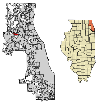
Bedford Park is a village in Cook County, Illinois, United States, and is an industrial suburb of Chicago. The population was 602 at the 2020 census. Bedford Park consists of a small residential area and vast amounts of heavy industry sprawling to the east and a small amount to the west.
Bellwood is a village in Proviso Township, Cook County, Illinois, United States. Located 13 miles (21 km) west of Chicago's downtown Loop, the Village of Bellwood is bounded by the Eisenhower Expressway (south), the Proviso yards of the former Chicago & Northwestern, now Union Pacific Railroad (north), and the suburbs of Maywood (east) and Hillside and Berkeley (west). The population was 18,789 at the 2020 census.
Broadview is a village in Cook County, Illinois, 12 miles (19 km) west of downtown Chicago. As of the 2020 census it had a population of 7,998.
Calumet Park is a village in Cook County, Illinois. The population was 7,025 at the 2020 census.
Deer Park is a village in Lake and Cook Counties, Illinois. Per the 2020 census, the population was 3,681. The village is one of the few left in the Chicago area that enjoy a green belt which is bordered by two large natural areas providing outdoor recreation and open space. The village is home to popular shopping and dining destinations: Deer Park Town Center and the Town Center Promenade. The town is also home to the Vehe Farm, an Illinois Centennial Farm.
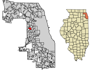
Forest View is a village in Cook County, Illinois, United States. Per the 2020 census, the population was 792. It is primarily an industrial corridor adjacent to the Chicago neighborhood of Garfield Ridge, which is on the village's southern border.
Glenwood is a village in Cook County, Illinois, United States. The population was 8,662 at the 2020 census.
Hanover Park is a village in Cook and DuPage counties in the U.S. state of Illinois, a suburb of Chicago. The population was 37,470 at the 2020 census. Ontarioville is a neighborhood within the village.
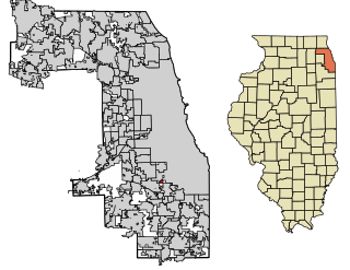
Merrionette Park is a village in Cook County, Illinois, United States. The population was 1,969 as of the 2020 census.
Orland Hills is a village in Cook County, Illinois, United States. Per the 2020 census, the population was 6,893.
Palos Park is a village in southwestern Cook County, Illinois, United States. Per the 2020 census, the population was 4,899.
Richton Park is a village and a south suburb of Chicago in Cook County, Illinois, United States. The population was 12,775 at the 2020 census.
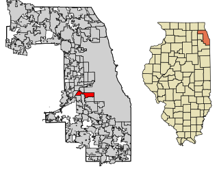
Stickney is a village in Cook County, Illinois, United States. The village is named for Alpheus Beede Stickney, a railroad executive who played a central role in establishing the Clearing Industrial District. Per the 2020 census, the population was 7,110. It was well known in the 1920s and early 1930s as the home for several bordellos linked to mobster Al Capone's empire.
Streamwood is a village in Cook County, Illinois, United States. Per the 2020 census, the population was 39,577. It is a northwest suburb of Chicago, and is a part of the Chicago metropolitan area.
Beach Park is a village in Benton and Waukegan townships of Lake County, Illinois, United States. Per the 2020 census, the population was 14,249.
Lakemoor is a village in Lake and McHenry counties in the U.S. state of Illinois. Per the 2020 census, the population was 6,182.
North Barrington is a village in Lake County, Illinois, United States. Per the 2020 census, the population was 3,171.
Atlanta is a city in Logan County, Illinois, United States. The population was 1,692 at the 2010 census.
The Village of Lakewood is a village in McHenry County, Illinois, United States. It was incorporated as a village on July 10, 1933. Per the 2020 census, the population was 4,283. Although commonly referred to as Lakewood, the town's proper name is preceded by 'The Village of'.
Centreville was a city in St. Clair County, Illinois, United States. The population was 5,309 in 2010, down from 5,951 at the 2000 census. On May 6, 2021, the city ceased to exist, being incorporated along with Alorton and Cahokia into the new city of Cahokia Heights.