
Ansonia is a city in New Haven County, Connecticut, United States, on the Naugatuck River, immediately north of Derby, and about 12 miles (19 km) northwest of New Haven. The population was 19,249 at the 2010 census. The ZIP code for Ansonia is 06401. The city is served by the Metro-North Railroad. Ansonia Station is a stop on the railroad passenger commuter service's Waterbury Branch connecting to New York's Grand Central Terminal. Ansonia also is served by the Connecticut Transit bus carrier. Connecticut Route 8 serves Ansonia.
Torrington is the largest city in Litchfield County, Connecticut and the Northwest Hills region. It is also the core city of Greater Torrington, one of the largest micropolitan areas in the United States. The city population was 36,383 according to the 2010 census.

The Naugatuck River is a 40.2-mile-long (64.7 km) river in the U.S. state of Connecticut. Its waters carve out the Naugatuck River Valley in the western reaches of the state, flowing generally due south and eventually emptying into the Housatonic River at Derby, Connecticut and thence 11 miles (18 km) to Long Island Sound. The Plume and Atwood Dam in Thomaston, completed in 1960 following the Great Flood of 1955, creates a reservoir on the river and is the last barrier to salmon and trout migrating up from the sea.

The Main Street Historic District encompasses the historic portion of the central business district of Willimantic, in Windham, Connecticut. The district encompasses the commercial business district of Willimantic and is roughly linear along Main Street and Riverside Drive between Church Street and Bridge Street. It was first listed on the National Register of Historic Places in 1982. Its area was increased in 1992 to include the Hall and Bill building on North Street, built in 1889 by one of Willimantic's leading printers.

The Downtown Torrington Historic District encompasses the historic central downtown area of Torrington, Connecticut. Centered on a crossing of the Naugatuck River, the 56-acre (23 ha) historic district is well-represented with architecture from the mid-19th to early 20th centuries. It was listed on the National Register of Historic Places in 1988.

The Hotchkissville Historic District is a historic district in the town of Hotchkissville, Connecticut adjacent to Woodbury, Connecticut that was listed on the National Register of Historic Places in 1995. It encompasses most of the historic village of Hotchkissville, which is centered at the junction of Washington and Weekeepeemee Roads. The village began as a dispersed rural agricultural community, but developed in the 19th century with the arrival of industry, primarily the manufacture of textiles. Despite this, the village has retained a significantly rural character, and includes a broad cross-section of 18th- and 19th-century architectural styles. Notable residents include the Wols family.
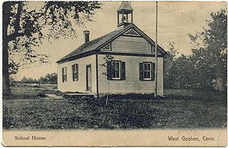
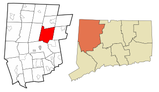
The West Goshen Historic District is a historic district in the village of West Goshen in the town of Goshen, Connecticut. It encompasses a well-preserved early 19th-century industrial village, with twenty historically significant properties in the village, most of which lie on Connecticut Route 4 between Beach Street and Thompson Road. The district was listed on the National Register of Historic Places in 1987.

The Milton Center Historic District encompasses the historic 19th-century village center of Milton in the northwestern part of the town of Litchfield, Connecticut. Basically linear, it stretches from Milton Cemetery in the west to the junction of Milton and Shearshop Roads in the east, including houses, churches, schools, and the remains of industrial sites. The district was listed on the National Register of Historic Places in 1986.

The Torringford Street Historic District is a historic district on the east side of the city of Torrington, Connecticut. The district includes properties along Torringford Street, the main thoroughfare of the Torringford section of the city, between United States Route 202 and West Hill Road. The road is one of the oldest in Torrington, and this section is notable for containing a cross-section of well-preserved architecture from the 18th to the mid-20th centuries. The district was listed on the National Register of Historic Places in 1991.

The Warrenton Woolen Mill is a historic textile mill at 839 Main Street in Torrington, Connecticut. Founded in 1844, the mill was a major part of the local economy until its closure in 1984. Its surviving complex, dating to the early 20th century, was listed on the National Register of Historic Places in 1987. It has since been renovated into housing, as the Warrenton Mill Condominiums.

The Downtown Waterbury Historic District is the core of the city of Waterbury, Connecticut, United States. It is a roughly rectangular area centered on West Main Street and Waterbury Green, the remnant of the original town commons, which has been called "one of the most attractive downtown parks in New England."

The Tilton Downtown Historic District encompasses a roughly one-block section of Main Street in the center of Tilton, New Hampshire. It extends from Central Street in the west to Bridge and School Streets in the east, including all of the buildings on the north side of this section, and a cluster of buildings on the south side near Bridge Street. The area has long been a commercial and industrial center for the town, although most of the buildings now date from the late 19th century onward, and include a fine array of Victorian architecture. The district was listed on the National Register of Historic Places in 1983.

The Bellows Falls Neighborhood Historic District encompasses a residential area of the village Bellows Falls, Vermont. Located south of downtown Bellows Falls, the area has one of the largest concentrations of well-preserved 19th century residences in southern Vermont. It was listed on the National Register of Historic Places in 2002, and enlarged in 2007.

The Bethel Village Historic District encompasses the historic core of the village of Bethel in the town of Bethel, Vermont, USA. The L-shaped district extends along Main and Church Streets, including many of the village's commercial and civic buildings, as well as a significant number of 19th and early 20th-century residences. The district was listed on the National Register of Historic Places in 1976, and was slightly enlarged in 1990.

The Springfield Downtown Historic District encompasses the historic central business district of the town of Springfield, Vermont. Located in a narrow valley on the banks of the Black River, the town's architecture is primarily reflective of its importance as a manufacturing center in the late 19th and early-to-mid 20th centuries, with a cluster of commercial buildings surrounded by residential and industrial areas. It was listed on the National Register of Historic Places in 1983, and enlarged slightly in 1986.

The Downtown Richford Historic District encompasses a cluster of commercial and industrial buildings at the center of Richford, Vermont. Centered on the junction of Main and River Streets are a cluster of mainly brick buildings, built between 1880 and 1920, with several industrial properties just across the Missisquoi River to the south, whose waters provided the power for the industries that fueled the town's growth. The district was listed on the National Register of Historic Places in 1980.

The Morrisville Historic District encompasses most of the historic commercial downtown area of the village of Morrisville in Morristown, Vermont. Developed in the early 19th century as a service town for the surrounding agricultural areas, it was transformed into a major service regional commercial center by the arrive of the railroad in 1872. Its surviving architecture is largely reflective of these two time periods. It was listed on the National Register of Historic Places in 1983, and enlarged in 2007.
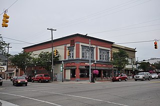
The Clare Downtown Historic District is a collection of 51 buildings located along four blocks of North McEwan Street in Clare, Michigan, along with adjacent portions of East and West Fourth Street and East and West Fifth Street. Street addresses of the structures run from 307 to 622 North McEwan, 114-120 East Fifth Street, 102-202 West Fifth Street, 112-115 East Fourth Street, and 112-124 West Fourth Street. The district was listed on the National Register of Historic Places in 2016.

The Downtown Seymour Historic District encompasses most of the historic downtown of Seymour, Connecticut. Sandwiched between Connecticut Route 8 and the tracks of the former Naugatuck Railroad line, now the Waterbury Branch, it developed in the mid-19th century as a successful industrial center dominated by the production of brass goods. The district was listed on the National Register of Historic Places in 1983.

The Naugatuck Center Historic District encompasses the historic civic and business center of Naugatuck, Connecticut. Centered around the town green, the district includes churches, schools and municipal buildings, many from the late 19th or early 20th centuries, as well as a diversity of residential architecture. The district was listed on the National Register of Historic Places in 1999.


