Weisshorn

Last updated

Weisshorn
Alps.jpg
North-east view of the Weisshorn
Highest point
Elevation 4,506 m (14,783 ft)
Prominence 1235 m Furggjoch [1]
Parent peak Monte Rosa
Isolation 11.0 km  Dom [2]
Coordinates 46°06′06″N7°42′58″E / 46.10167°N 7.71611°E / 46.10167; 7.71611
Naming
English translationwhite peak/mountain
Geography
Switzerland relief location map.jpg
Red triangle with thick white border.svg
Weisshorn
Location in Switzerland
Location Valais, Switzerland
Parent range Pennine Alps
Topo map Swisstopo 1328 Randa
Climbing
First ascent 19 August 1861 by John Tyndall with guides J.J. Bennen and Ulrich Wenger
Easiest route rock/snow/ice climb

The Weisshorn (German, lit. white peak/mountain) is a major peak of Switzerland and the Alps, [3] culminating at 4,506 metres (14,783 feet) above sea level. It is part of the Pennine Alps and is located between the valleys of Anniviers and Zermatt in the canton of Valais. In the latter valley, the Weisshorn is one of the many 4000ers surrounding Zermatt, with Monte Rosa and the Matterhorn.

Contents

The Weisshorn was first climbed in 1861 from Randa by the Irish physicist John Tyndall, accompanied by the guides J.J. Bennen and Ulrich Wenger. Nowadays, the Weisshorn Hut is used on the normal route. The Weisshorn is considered by many mountaineers to be the most beautiful mountain in the Alps and Switzerland for its pyramidal shape and pure white slopes. [4] [5] [6] [7]

In April and May 1991, two consecutive rockslides occurred from a cliff above the town of Randa on the east side of the massif, below the Bis Glacier.

Geography

The Weisshorn is situated in the southern canton of Valais, about 25 km southwards from the Rhone between Sierre and Visp. It is the culminating point on the north–south orientated chain separating the Val d'Anniviers to the west and the Mattertal to the east and enclosing the Turtmanntal to the north, the tripoint between these valleys being located just north of its main summit. The Weisshorn faces the slightly higher Dom across the Mattertal, with the village of Randa 3100 metres below these two summits. After the Dom, the Weisshorn is the second-highest Alpine summit situated completely out the main chain and fully within Switzerland. On both sides of the Weisshorn range, the water end up in the Rhone, through the Navizence (west) and the Vispa (east). The Weisshorn and the Dom are only two of the many 4000-metre peaks surrounding the region of Zermatt, along with the Zinalrothorn, the Dent Blanche, the Dent d'Hérens, the Matterhorn and, second highest in the Alps, Monte Rosa.

The Weisshorn has a pyramidal shape and its faces are separated by three ridges descending steeply from the summit. Two of these are nearly in a straight line, one running approximately north and the other south. The third ridge is nearly at right angles to these two, running almost due east. In the compartment between the northern and eastern spurs lies the Bis Glacier (Bisgletscher). It is connected with the summit by long and extremely steep slopes of snow. In the compartment between the eastern and southern spurs lies the Schali Glacier (Schaligletscher). Ranges of steep rocks rise round the whole basin of this glacier, except in one or two places where they are interrupted by couloirs of snow. Finally, on the western side the mountain presents one gigantic face of rocky precipice. This face rises above the Weisshorn Glacier (Glacier du Weisshorn) and the Moming Glacier. The northern spur forks out at a considerable distance below the summit into two branches enclosing the Turtmann Glacier. The eastern branch connects the mountain with the Bishorn (4,153 m), across the Weisshornjoch. [8]

Geology

Close-up view from the Barrhorn with the north face of the Bishorn in foreground Weisshorn3.jpg
Close-up view from the Barrhorn with the north face of the Bishorn in foreground

The Weisshorn is the culminating point of the Dent Blanche nappe, a klippe belonging to the Austroalpine nappes. The mountain is composed of gneisses; the west face is also composed of sedimentary rocks from the cretaceous period. [9]

Climbing history

The mountain was first climbed on 19 August 1861 by the physicist John Tyndall, with guides J. J. Bennen and Ulrich Wenger. Their itinerary corresponds to the normal route for climbing the mountain today: the east ridge, starting from the Weisshorn Hut. [10]

1860 attempt

The south-east face (the Schaligrat on the left, the east ridge on the right) rising over the Schali Glacier Weisshorn East.jpg
The south-east face (the Schaligrat on the left, the east ridge on the right) rising over the Schali Glacier

In 1860 an attempt was made by C. E. Mathews by the southern face. He came to Zermatt with Melchior Anderegg, and engaged Johann Kronig as second guide. They slept at the huts of Schallenbergalp and started at half-past one on the morning of 1 July. Crossing the moraine, they walked until they reached a steep and rugged portion of the glacier, which hid the mountain from their view; and rounding this obstruction with some difficulty, they reached the upper portion of the glacier about five o'clock. They saw that the ridges were thickly coated over with fresh snow, and, except a little patch of rock some 700 or 800 feet (240 m) below the summit, the whole mass was of brilliant and dazzling whiteness. They decided to try the southern side which seemed less steep and more practicable to Melchior but an avalanche stopped them: [11]

"For six mortal hours we toiled up the steep face of the mountain...A great many steps had to be cut, but for the most part we were able to tread out our foot-holds in the snow. About half-past nine the difficulties became much greater - ten or twelve inches of snow rested upon the ice. We could not get safe footing upon it, and my clinometer indicated an angle of 48 or 49 degrees. The necessity of clearing away the snow before the step could be cut in the ice beneath it, made Melchior's work very arduous, and the higher we got the greater the difficulties became. We had to take off veil and spectacles, and use all our eyes, the footholds were so insecure, and this, though the sun was extremely hot and there was not a cloud to be seen. Suddenly the heat of the sun loosened some snow just above us, and down came a little avalanche quite near enough to be exceedingly unpleasant." [11]

The guide Kronig asked Mathews to give up the expedition. They turned back and reached Zermatt in the evening, after nineteen hours of walking. They experienced other avalanches on the descent and the eyes of Mathews were severely burnt. [11]

First ascent

Climbers on the east ridge Weisshorn, east ridge.jpg
Climbers on the east ridge

Accompanied by the guides J.J. Bennen, of Laax, and Ulrich Wenger, of Grindelwald, John Tyndall started the ascent from Randa at 1.00 p.m. on 18 August 1861. They had a bivouac and resumed the climb at 3.35 a.m. on the next day. Tyndall was optimistic but the ascent became difficult, he wrote: [12]

"Sometimes it was a fair pull upwards, sometimes an oblique twist round the corner of a rock tower; sometimes it was the grip of the finger ends in a fissure and lateral shifting of the whole body in a line parallel to the crack. Many times I found myself with my feet highest and my head lowest." [12]

They reached a dangerous thin ridge of snow, little wider than a hand's breadth, with precipices on either side. The guide Bennen trod the snow down and saw that it was firm enough to cross. Tyndall and Wenger followed Bennen, but yet the summit seemed less attainable and they were all tired. However Tyndall steeled himself with patriotic thoughts: [12]

"I thought of Englishmen in battle, of the qualities which had made them famous: it was mainly the quality of not knowing when to yield - of fighting for duty even after they had ceased to be animated by hope. Such thoughts helped to lift me over the rocks." [12]

After four hours of struggle they reached a sharp ridge of snow and finally arrived to the summit. The return was found to be not much less difficult than the ascent; and they regained Randa at 11 p.m., after about 20 hours of almost constant hard work. [12]

Other ascents

The north ridge seen from the Bishorn, with the Grand Gendarme in the middle Weisshorn from Bishorn.JPG
The north ridge seen from the Bishorn, with the Grand Gendarme in the middle

The second ascent, in 1862, was made by Leslie Stephen. Starting with Melchior Anderegg and Franz Biener, of Zermatt. It was from a chalet below the Schallenberg Alp, nearly 2 hours lower than Tyndall's bivouac, that Stephen gained the highest point in 9.5 hours, and returned to Randa in 7.5 hours more, reaching Zermatt the same evening. [11]

In 1877, another route was opened by W. E. Davidson, J. W. Hartley and H. S. Hoare, with guides P. Rubi, J. Juan and A. Pollinger. After climbing part of the lower south-east face above the Schali Glacier, they reached the Schaligrat (south-west ridge) and continued to the summit. The complete ridge (which was considered too difficult and dangerous in its lower part) was first climbed in 1895 by J. M. Biner, A. Imboden and E. Broome. The south-east face was completely climbed in 1906 by Geoffrey Winthrop Young and R.G. Mayor with the guide Josef Knubel of St. Niklaus in the canton Valais. [10]

The west face Weisshorn, Zinal.jpg
The west face

The glaciated north-east face was first climbed in 1871 by J. H. Kitson with guides Christian Almer and his son. Almer wanted to reach the summit by nine o'clock in the morning while Kitson's wife watched them from the Gornergrat. In fact the difficulties were more serious than expected and they didn't reach the summit before midday. Shortly after, the ascent was repeated by W. A. B. Coolidge and Meta Brevoort. Both expeditions climbed the part of the face below the Grand Gendarme and continued near the north ridge. In 1909 G. W. Young and J. Knubel climbed the face by the central spur. [10]

The west face was first climbed in 1879 by G. A. Passingham with guides F. Imseng and L. Zurbrücken. Other routes on the face were opened in 1883 and 1889. The easiest passage on the east face was found in 1890 by G. W. Young, who climbed the spur under the Grand Gendarme with L. and B. Theytaz by a route known as the Younggrat.

The summit of the Grand Gendarme on the unexplored north ridge was first reached in 1898. One month later, on 21 September 1898, H. Biehly and H. Burgener made the first complete traverse on the north ridge to the summit from the Bishorn.

Bishorn and Weisshorn from the Turtmanntal side Bishorn-weisshorn.jpg
Bishorn and Weisshorn from the Turtmanntal side

In 1888 George Winkler was killed in a fall on the west face. He left Zinal alone on 17 August, without telling others his precise route. The rescue team only found a photo and a hat near an avalanche cone. His body was not found until the summer of 1956, on the Weisshorn Glacier. John Garforth Cockin was also killed making a solo attempt on the south-east face twelve years later. [10]

In 1925 Eleonore Noll-Hasenclever, H. Pfann and H. Trier were caught in an avalanche on the north-east face when they tried to reach the east ridge after interrupting their ascent on the north ridge on account of adverse weather conditions. Pfann and Trier survived, but Hasenclever died from asphyxiation. [10]

1983 helicopter crash

An Alouette III helicopter from Air Zermatt crashed on a night flight on the Schali Glacier (south of the peak) on 31 July 1983. The helicopter was carrying the pilot, his assistant and a mountain guide who was searching for two missing alpinists. A false alarm made the pilot try to land the helicopter on the glacier at 3,160 m. All the crew were severely injured but the guide and pilot survived. The two missing alpinists were later found dead. [13]

Climbing routes

All the routes are difficult. The normal route starts from the Weisshorn Hut on the east side and goes along the sharp east ridge.

The Weisshorn can be climbed from the Bishorn via the north ridge, departing from the Cabane de Tracuit, above Zinal. The first three hours consist of relatively easy walking across the glacier and lead to the summit of the Bishorn (4153 m). The second part of the ascent is very exposed and takes another five hours, during which the Grand Gendarme must be climbed. [10]

See also

Related Research Articles

<span class="mw-page-title-main">Matterhorn</span> Mountain in the Swiss and Italian Alps

The Matterhorn is a mountain of the Alps, straddling the main watershed and border between Italy and Switzerland. It is a large, near-symmetric pyramidal peak in the extended Monte Rosa area of the Pennine Alps, whose summit is 4,478 metres (14,692 ft) above sea level, making it one of the highest summits in the Alps and Europe. The four steep faces, rising above the surrounding glaciers, face the four compass points and are split by the Hörnli, Furggen, Leone/Lion, and Zmutt ridges. The mountain overlooks the Swiss town of Zermatt, in the canton of Valais, to the northeast; and the Italian town of Breuil-Cervinia in the Aosta Valley to the south. Just east of the Matterhorn is Theodul Pass, the main passage between the two valleys on its north and south sides, which has been a trade route since the Roman Era.

<span class="mw-page-title-main">Jungfrau</span> Mountain summit in the Bernese Alps, between the Swiss cantons of Bern and Valais

The Jungfrau, at 4,158 meters (13,642 ft) is one of the main summits of the Bernese Alps, located between the northern canton of Bern and the southern canton of Valais, halfway between Interlaken and Fiesch. Together with the Eiger and Mönch, the Jungfrau forms a massive wall of mountains overlooking the Bernese Oberland and the Swiss Plateau, one of the most distinctive sights of the Swiss Alps.

<span class="mw-page-title-main">Eiger</span> Mountain in the Bernese Alps, Switzerland

The Eiger is a 3,967-metre (13,015 ft) mountain of the Bernese Alps, overlooking Grindelwald and Lauterbrunnen in the Bernese Oberland of Switzerland, just north of the main watershed and border with Valais. It is the easternmost peak of a ridge crest that extends across the Mönch to the Jungfrau at 4,158 m (13,642 ft), constituting one of the most emblematic sights of the Swiss Alps. While the northern side of the mountain rises more than 3,000 m (10,000 ft) above the two valleys of Grindelwald and Lauterbrunnen, the southern side faces the large glaciers of the Jungfrau-Aletsch area, the most glaciated region in the Alps. The most notable feature of the Eiger is its nearly 1,800-metre-high (5,900 ft) north face of rock and ice, named Eiger-Nordwand, Eigerwand or just Nordwand, which is the biggest north face in the Alps. This huge face towers over the resort of Kleine Scheidegg at its base, on the eponymous pass connecting the two valleys.

<span class="mw-page-title-main">Dent Blanche</span> Mountain in the Pennine Alps in Valais Canton, Switzerland

The Dent Blanche is a mountain in the Pennine Alps, lying in the canton of Valais in Switzerland. At 4,357 m (14,295 ft)-high, it is one of the highest peaks in the Alps.

<span class="mw-page-title-main">Dufourspitze</span> Highest mountain in Switzerland

The Dufourspitze is the highest peak of Monte Rosa, an ice-covered mountain massif in the Alps. Dufourspitze is the highest mountain of both Switzerland and the Pennine Alps and is also the second-highest mountain of the Alps and Western Europe, after Mont Blanc. It is located between Switzerland and Italy. The peak itself is located wholly in Switzerland.

<span class="mw-page-title-main">Aiguille de Bionnassay</span> Mountain in the Mont Blanc massif

The Aiguille de Bionnassay is a mountain in the Mont Blanc massif of the Alps in France and Italy. It has been described as "one of the most attractive satellite peaks of Mont Blanc", and is located on its western side. The mountain's south and east ridges form the frontier between the two countries, and its summit is a knife-edge crest of snow and ice. Reaching it via any route provides a "splendid and serious snow and ice climb".

<span class="mw-page-title-main">Aletschhorn</span> Mountain in the Bernese Alps

The Aletschhorn is a mountain in the Alps in Switzerland, lying within the Jungfrau-Aletsch region, which has been designated a World Heritage Site by UNESCO. The mountain shares part of its name with the Aletsch Glacier lying at its foot.

<span class="mw-page-title-main">Dom (mountain)</span> Mountain in the Pennine Alps, Switzerland

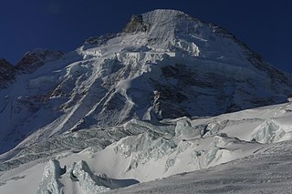
The Dom is a mountain of the Pennine Alps, located between Randa and Saas-Fee in the canton of Valais in Switzerland. With a height of 4,545 m (14,911 ft), it is the seventh highest summit in the Alps, overall. Based on prominence, it can be regarded as the third highest mountain in the Alps, and the second highest in Switzerland, after Monte Rosa. The Dom is the main summit of the Mischabel group, which is the highest massif lying entirely in Switzerland.

<span class="mw-page-title-main">Grand Combin</span> Mountain massif in the western Pennine Alps, in the Swiss canton of Valais

The Grand Combin is a mountain massif in the western Pennine Alps in the canton of Valais. At a height of 4,314 metres (14,154 ft) the summit of Combin de Grafeneire is one of the highest peaks in the Alps and the second most prominent of the Pennine Alps. The Grand Combin is also a large glaciated massif consisting of several summits, among which three are above 4000 metres. The highest part of the massif is wholly in Switzerland, although the border with Italy lies a few kilometres south.

<span class="mw-page-title-main">Lyskamm</span> Mountain in the Pennine Alps

Lyskamm, also known as Silberbast, is a mountain in the Pennine Alps lying on the border between Switzerland and Italy. It consists of a five-kilometre-long ridge with two distinct peaks. The mountain has gained a reputation for seriousness because of the many cornices lying on the ridge and the frequent avalanches, thus leading to its nickname the Menschenfresser.

<span class="mw-page-title-main">Ober Gabelhorn</span> Mountain in the Pennine Alps in Switzerland

The Ober Gabelhorn is a mountain in the Pennine Alps in Switzerland, located between Zermatt and Zinal.

<span class="mw-page-title-main">Zinalrothorn</span> Mountain in the Pennine Alps

The Zinalrothorn is a mountain in the Pennine Alps in Switzerland. Its name comes from the village of Zinal lying on the north side and from the German word Rothorn which means Red Peak. When it was first climbed in 1864 the mountain was known locally as Moming.

<span class="mw-page-title-main">Dent d'Hérens</span> Mountain in the Pennine Alps

The Dent d'Hérens is a mountain in the Pennine Alps, lying on the border between Italy and Switzerland. The mountain lies a few kilometres west of the Matterhorn.

<span class="mw-page-title-main">Täschhorn</span> Mountain in Switzerland

The Täschhorn is a mountain in the Pennine range of the Alps in Switzerland. There are no easy mountaineering routes to its summit, and it is regarded as being among the top ten 4,000-metre mountains in the Alps for difficulty, and "one of the highest, finest and least accessible 4000m mountains". It lies immediately north of the Alphubel, and south of the Dom within the Mischabel range, and is very similar in shape to the Dom when seen from the upper Zermatt valley.

<span class="mw-page-title-main">Alphubel</span> Mountain in the Pennine Alps

The Alphubel is a mountain of the Swiss Pennine Alps, located between the valleys of Zermatt and Saas in the canton of Valais. It is part of the Allalin Group, a subgroup of the Mischabel Group, which culminates at the Dom. The summit of the Alphubel consists of a large ice-covered plateau, part of the Fee Glacier on its east side. The west side of the mountain is more rocky and much steeper. It overlooks the Weingartensee.

<span class="mw-page-title-main">Bishorn</span> Mountain in Switzerland

The Bishorn is a mountain in the Pennine Alps in Switzerland, just north of the Weisshorn.

<span class="mw-page-title-main">First ascent of the Matterhorn</span> 1865 mountaineering expedition in the Pennine Alps

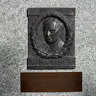
The first ascent of the Matterhorn was a mountaineering expedition made by Edward Whymper, Lord Francis Douglas, Charles Hudson, Douglas Hadow, Michel Croz, and two Zermatt guides, Peter Taugwalder and his son of the same name, on 14 July 1865. Douglas, Hudson, Hadow and Croz were killed on the descent when Hadow slipped and pulled the other three with him down the north face. Whymper and the Taugwalder guides, who survived, were later accused of having cut the rope below to ensure that they were not dragged down with the others, but the subsequent inquiry found no evidence of this and they were acquitted.

<span class="mw-page-title-main">Goûter Route</span> Mountain route to reach Mont Blanc summit

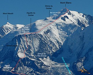
The Goûter Route is one of the two normal mountaineering routes used to reach the summit of Mont Blanc in the Alps, ascending to a height of 4,808 metres (15,774 ft). The route lies on the north side of the mountain, in France. Usually reckoned as the easiest route up Mont Blanc, it is extremely popular with mountaineers, seeing thousands of ascents per year.

Eleonore Noll-Hasenclever was a German alpinist who mainly climbed in the Swiss Alps. During her lifetime, she climbed more than 150 summits that measured 12,000 feet and above. In 1925, she died due to an avalanche on her descent of the Bishorn.

References

  1. Swisstopo map (the Furggjoch is the key col at 3,271 metres)
  2. Retrieved from Google Earth. The nearest point of higher elevation is west of the Dom.
  3. Considering peak with at least 300 metres prominence, the Weisshorn is the fifth highest in the Alps and fourth highest in Switzerland.
  4. Williams, Cicely (1964). Zermatt Saga. George Allen and Unwin. p. 104.
  5. Sharp, Hilary (2015). Tour of Monte Rosa: A Trekker's Guide. Cicerone Press. p. 154. ISBN   9781783621842.
  6. Morell, John (1867). Scientific Guide to Switzerland. Smith, Elder and Company. p. 14.
  7. Goodfellow, Basil (1952). "The Weisshorn Horseshoe" (PDF). Alpine Journal . Alpine Club. 58: 465–68. Retrieved 28 September 2015.
  8. Alpine Club (UK), The Alpine journale, volume 1, 1864
  9. Geologic map of Switzerland 1:500 000, Bundesamt für Wasser und Geologie, CH-3003 Bern-Ittigen, ISBN   3-906723-39-9
  10. 1 2 3 4 5 6 Helmut Dumler,Willi P. Burkhardt, Les 4000 des Alpes, ISBN   2-7003-1305-4
  11. 1 2 3 4 Alpine Club (UK), The Alpine journal, volume 1, 1864
  12. 1 2 3 4 5 Fergus Fleming, Killing Dragons: The conquest of the Alps, p. 202, 2002
  13. Schlußbericht der Eidgenössischen Flugunfall-Untersuchungskommission Archived 6 July 2011 at the Wayback Machine admin.ch