Welsh Marches

Last updated

The Welsh Marches (Welsh : Y Mers) is an imprecisely defined area along the border between England and Wales in the United Kingdom. The precise meaning of the term has varied at different periods.

Contents

The English term Welsh March (in Medieval Latin Marchia Walliae) [1] was originally used in the Middle Ages to denote the marches between England and the Principality of Wales, in which Marcher lords had specific rights, exercised to some extent independently of the king of England. In modern usage, "the Marches" is often used to describe those English counties which lie along the border with Wales, particularly Shropshire and Herefordshire, and sometimes adjoining areas of Wales. However, at one time the Marches included all of the historic counties of Cheshire, Shropshire, Herefordshire, Worcestershire and Gloucestershire.

Etymology

The term March is from the 13th-century Middle English marche ("border region, frontier"). The term was borrowed from Old French marche ("limit, boundary"), itself borrowed from a Frankish term derived from Proto-Germanic *markō ("border, area"). The term is a doublet of English mark, and is cognate with German Mark ("boundary"). [2] Cognates are found in the English toponyms "Mercia" and "Mersey", and in continental place-names containing mark, such as "Denmark".

The term is distantly related to the verb march, both ultimately derived from Proto-Indo-European *mereg-, "edge" or "boundary".

Origins: Mercia and the Welsh

Offa's Dyke near Clun in Shropshire Offa's Dyke near Clun.jpg
Offa's Dyke near Clun in Shropshire

After the decline and fall of the Roman Empire which occupied southern Britain until about AD 410, the area which is now Wales comprised a number of separate Romano-British kingdoms, including Powys in the east. Over the next few centuries, the Angles, Saxons and others gradually conquered and settled in eastern and southern Britain. The kingdom of Mercia, under Penda, became established around Lichfield, and initially established strong alliances with the Welsh kings.

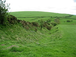
However, his successors sought to expand Mercia further westwards into what is now Cheshire, Shropshire and Herefordshire. As the power of Mercia grew, a string of garrisoned market towns such as Shrewsbury and Hereford defined the borderlands as much as Offa's Dyke, a stronger and longer boundary earthwork erected by order of Offa of Mercia between AD 757 and 796. The Dyke still exists, and can best be seen at Knighton, close to the modern border between England and Wales. [3] Campaigns and raids from Powys led, possibly around about AD 820, to the building of Wat's Dyke, a boundary earthwork extending from the Severn valley near Oswestry to the Dee estuary. [4] [5]

In the centuries which followed, Offa's Dyke largely remained the frontier between the Welsh and English. Æthelstan, often seen as the first king of a united England, summoned the British kings to a meeting at Hereford in AD 926, and according to William of Malmesbury laid down the boundary between Wales and England, particularly the disputed southern stretch where he specified that the River Wye should form the boundary. [6]

By the mid-eleventh century, Wales was united under Gruffydd ap Llywelyn of Gwynedd, until his death in 1063.[ citation needed ]

The Marches in the Middle Ages

Immediately after the Norman Conquest, King William of England installed three of his most trusted confidants, Hugh d'Avranches, Roger de Montgomerie, and William FitzOsbern, as Earls of Chester, Shrewsbury and Hereford respectively, with responsibilities for containing and subduing the Welsh. The process took a century and was never permanently effective. [7]

The term "March of Wales" was first used in the Domesday Book of 1086. Over the next four centuries, Norman lords established mostly small marcher lordships between the Dee and Severn, and further west. Military adventurers went to Wales from Normandy and elsewhere and after raiding an area of Wales, then fortified it and granted land to some of their supporters. [8]

One example was Bernard de Neufmarché, responsible for conquering and pacifying the Welsh kingdom of Brycheiniog. The precise dates and means of formation of the lordships varied, as did their size.

Wales in the 14th Century showing Marcher Lordships Wales 14C Map.png
Wales in the 14th Century showing Marcher Lordships

The March, or Marchia Wallie, was to a greater or lesser extent independent of both the English monarchy and the Principality of Wales or Pura Wallia, which remained based in Gwynedd in the north west of the country. By about AD 1100 the March covered the areas which would later become Monmouthshire and much of Flintshire, Montgomeryshire, Radnorshire, Brecknockshire, Glamorgan, Carmarthenshire and Pembrokeshire. Ultimately, this amounted to about two-thirds of Wales. [4] [9] [10]

During the period, the Marches were a frontier society in every sense, and a stamp was set on the region that lasted into the time of the Industrial Revolution. Hundreds of small castles were built in the border area in the 12th and 13th centuries, predominantly by Norman lords as assertions of power as well as defences against Welsh raiders and rebels. The area still contains Britain's densest concentration of motte-and-bailey castles. The Marcher lords encouraged immigration from all the Norman-Angevin realms, and encouraged trade from "fair haven" ports like Cardiff. Peasants went to Wales in large numbers: Henry I encouraged Bretons, Flemings, Normans, and English settlers to move into the south of Wales. Many new towns were established, some such as Chepstow, Monmouth, Ludlow and Newtown becoming successful trading centres, and these tended also to be a focus of English settlement. At the same time, the Welsh continued to attack English soil and supported rebellions against the Normans. [4]

The Norman lords each had similar rights to the Welsh princes. Each owed personal allegiance, as subjects, to the English king whom they were bound to support in times of war, but their lands were exempt from royal taxation and they possessed rights which elsewhere were reserved to the crown, such as the rights to create forests, markets and boroughs. [10]

The lordships were geographically compact and jurisdictionally separate one from another, and their privileges differentiated them from English lordships. Marcher lords ruled their lands by their own law—sicut regale ("like unto a king") as Gilbert de Clare, 7th Earl of Gloucester stated [11] — whereas in England fief-holders were directly accountable to the king. The crown's powers in the Marches were normally limited to those periods when the king held a lordship in its own hands, such as when it was forfeited for treason or on the death of the lord without a legitimate heir whereupon the title reverted to the Crown in escheat. At the top of a culturally diverse, intensely feudalised and local society, the Marcher barons combined the authority of feudal lord and vassal of the King among their Normans, and of supplanting the traditional tywysog among their conquered Welsh. However, Welsh law was sometimes used in the Marches in preference to English law, and there were disputes as to which code should be used to decide a particular case. From this developed the distinctive March law. [4] [5] [11]

The Statute of Rhuddlan in 1284 followed the conquest of the Principality by Edward I of England. It assumed the lands held by the Princes of Gwynedd under the title "Prince of Wales" as legally part of the lands of the Crown, and established shire counties on the English model over those areas. The Marcher Lords were progressively tied to the English kings by the grants of lands and lordships in England, where control was stricter, and where many marcher lords spent most of their time, and through the English kings' dynastic alliances with the great magnates. The Council of Wales and the Marches, administered from Ludlow Castle, was initially established in 1472 by Edward IV of England to govern the lands held under the Principality of Wales which had become directly administered by the English crown following the Edwardian conquest of Wales in the 13th century. [12]

The end of Marcher powers

Marches in Wales Act 1534
Act of Parliament
Coat of Arms of Henry VIII of England (1509-1547).svg
Long title An Act that Murthers and Felonies done or committed within any Lordship Marcher in Wales, shall be inquired of at the Sessions holden within the Shire Grounds next adjoining; with many goods Orders for Ministration of Justice there to be had.
Citation 26 Hen. 8. c. 6
Dates
Royal assent 18 December 1534

By the 16th century, many marcher lordships had passed into the hands of the crown, as the result of the accessions of Henry IV, who was previously Duke of Lancaster, and Edward IV, the heir of the Earls of March; of the attainder of other lords during the Wars of the Roses; and of other events. The crown was also directly responsible for the government of the Principality of Wales, which had its own institutions and was, like England, divided into counties. The jurisdiction of the remaining marcher lords was therefore seen as an anomaly, and their independence from the crown enabled criminals from England to evade justice by moving into the area and claiming "marcher liberties".[ citation needed ]

Under the Laws in Wales Acts 1535–1542 introduced under Henry VIII, the jurisdiction of the marcher lords was abolished in 1536. The Acts had the effect of annexing Wales with England and creating a single state and legal jurisdiction, commonly referred to as England and Wales. The powers of the marcher lordships were abolished, and their areas were organised into the new Welsh counties of Denbighshire, Montgomeryshire, Radnorshire, Brecknockshire, Monmouthshire, and Carmarthenshire. The counties of Pembrokeshire and Glamorgan were created by adding other districts to existing lordships. In place of assize courts of England, there were Courts of Great Sessions. These administered English law, in contrast with the marcher lordships, which had administered Welsh law for their Welsh subjects. Some lordships were added to adjoining English counties: Ludlow, Clun, Caus and part of Montgomery were incorporated into Shropshire; Wigmore, Huntington, Clifford and most of Ewyas were included in Herefordshire; and that part of Chepstow east of the River Wye was included in Gloucestershire. [4]

The Council of Wales, based at Ludlow Castle, was reconstituted as the Council of Wales and the Marches, with statutory responsibilities for the whole of Wales together with, initially, Cheshire, Shropshire, Herefordshire, Worcestershire and Gloucestershire. The City of Bristol was exempted in 1562, and Cheshire in 1569. [13] [14]

The Council was eventually abolished in 1689, following the "Glorious Revolution" which overthrew James II (VII of Scotland) and established William III (William of Orange) as king.[ citation needed ]

List of Marcher lordships and successor shires

List of Marcher lordships and successor shires: [8]

The Marches today

Welsh Marches Line Welsh Marches line.png
Welsh Marches Line
A Class 175 'Coradia' running through currently closed Dinmore railway station, Herefordshire on the Welsh Marches Line on an Arriva Trains Wales service. Northbound Train Passing Dinmore - geograph.org.uk - 1365622.jpg
A Class 175 'Coradia' running through currently closed Dinmore railway station, Herefordshire on the Welsh Marches Line on an Arriva Trains Wales service.

There is no modern legal or official definition of the extent of the Welsh Marches. However, the term the Welsh Marches (or sometimes just the Marches) is commonly used to describe those English counties which lie along the border with Wales, particularly Shropshire and Herefordshire. [16] The term is also sometimes applied to parts of Powys, Monmouthshire and Wrexham. [17]

The Welsh Marches Line is a railway line from Newport in the south of Wales to Shrewsbury, via Abergavenny, Hereford, and Craven Arms.

The Marches Way is a long distance footpath which connects Chester in the north of England, via Whitchurch, Shrewsbury, Leominster and Abergavenny to the Welsh capital, Cardiff.

The Marches School is a secondary school in Oswestry, Shropshire. The school has several meeting rooms named in Welsh, and has students and staff from both sides of the border.

See also

Notes

  1. Often rendered Marcia Wallie in documents.
  2. "march". Online Etymology Dictionary. Retrieved 1 November 2023.
  3. David Hill and Margaret Worthington, Offa's Dyke – history and guide, Tempus Publishing, 2003; ISBN   0-7524-1958-7
  4. 1 2 3 4 5 John Davies, A History of Wales, Penguin, 1993; ISBN   0-14-028475-3
  5. 1 2 Trevor Rowley, The Welsh Border – archaeology, history and landscape, Tempus Publishing, 1986; ISBN   0-7524-1917-X
  6. Roderick, A. J. (1952). "The feudal relation between the English crown and the Welsh princes". The Journal of the Historical Association. 37 (131): 201–212. doi:10.1111/j.1468-229X.1952.tb00238.x. Archived from the original on 27 August 2020. Retrieved 27 August 2020.
  7. "Norman Castles". www.castlewales.com. Archived from the original on 20 December 2008. Retrieved 20 December 2008.
  8. 1 2 Max Lieberman, The March of Wales, 1067–1300: a borderland of medieval Britain, University of Wales Press, 2008; ISBN   978-0-7083-2115-7
  9. Davies, R. R., The Age of Conquest: Wales 1063–1415 (Oxford 1987, 2000 edition), pp. 271–88.
  10. 1 2 Paul Courtney, The Marcher Lordships: Origins, Descent and Organization, in The Gwent County History Vol. 2, University of Wales Press, Cardiff, 2008; ISBN   978-0-7083-2072-3
  11. 1 2 Nelson, Lynn H., 1966. The Normans in South Wales Archived 10 April 2005 at the Wayback Machine , 1070–1171 (Austin and London: University of Texas Press)
  12. William Searle Holdsworth, A History of English Law, Little, Brown, and Company, 1912, pg. 502
  13. "Welsh Joint Education Committee: The Council of Wales and the Marches". Archived from the original on 4 March 2009. Retrieved 20 December 2008.
  14. Marriott, Sir John Arthur Ransome (17 June 1938). This Realm of England; Monarchy, Aristocracy, Democracy. Books for Libraries Press. ISBN   9780836956115. Archived from the original on 15 May 2019. Retrieved 7 February 2016 via Google Books.
  15. P. Brown, P. King, and P. Remfry, 'Whittington Castle: The marcher fortress of the Fitz Warin family', Shropshire Archaeology and History LXXIX (2004), 106–127.
  16. "The Marches". The Marches Local Enterprise Partnership. Archived from the original on 23 July 2016. Retrieved 30 June 2016. "The Welsh Marches". Ludlow.org.uk. Archived from the original on 5 March 2016. Retrieved 30 June 2016.
  17. "The Autumn Epic, Welsh Marches, Powys". TheGuardian.com. 2 March 2007. Archived from the original on 22 August 2016. Retrieved 30 June 2016. "Discover Herefordshire and the Southern Marches". Countryfile.com. Archived from the original on 15 August 2016. Retrieved 30 June 2016. "Chirk Castle – Magnificent medieval fortress of the Welsh Marches". NationalTrust.org.uk. Archived from the original on 10 July 2016. Retrieved 30 June 2016.

Related Research Articles

<span class="mw-page-title-main">Marcher lord</span> English noble appointed to protect the border with Wales

A marcher lord was a noble appointed by the king of England to guard the border between England and Wales.

<span class="mw-page-title-main">Historic counties of Wales</span> Sub-divisions in Wales

The historic counties of Wales were the thirteen sub-divisions used in Wales from either 1282 and 1535, up to their abolishment in 1974 for eight counties. They were used for various functions for several hundred years, but for administrative purposes have been superseded by contemporary sub-national divisions, some of which bear some limited similarity to the historic entities in name and extent. They are alternatively known as ancient counties.

<span class="mw-page-title-main">Kingdom of Powys</span> 400s–1160 kingdom in east-central Wales

The Kingdom of Powys was a Welsh successor state, petty kingdom and principality that emerged during the Middle Ages following the end of Roman rule in Britain. It very roughly covered the northern two-thirds of the modern county of Powys and part of today's English West Midlands. More precisely, and based on the Romano-British tribal lands of the Ordovices in the west and the Cornovii in the east, its boundaries originally extended from the Cambrian Mountains in the west to include the modern West Midlands region of England in the east. The fertile river valleys of the Severn and Tern are found here, and this region is referred to in later Welsh literature as "the Paradise of Powys".

<span class="mw-page-title-main">Maelor</span> Area of Wales

The Maelor is an area of north-east Wales along the border with England. It is now entirely part of Wrexham County Borough. The name Maelor is an old Welsh word: it can be translated as "land of the prince", from mael ("prince") and llawr.

The history of Herefordshire starts with a shire in the time of King Athelstan, and Herefordshire is mentioned in the Anglo-Saxon Chronicle in 1051. The first Anglo-Saxon settlers, the 7th-century Magonsætan, were a sub-tribal unit of the Hwicce who occupied the Severn valley. The Magonsætan were said to be in the intervening lands between the Rivers Wye and Severn. The undulating hills of marl clay were surrounded by the Welsh mountains to the west; by the Malvern Hills to the east; by the Clent Hills of the Shropshire borders to the north, and by the indeterminate extent of the Forest of Dean to the south. The shire name first recorded in the Anglo-Saxon Chronicle may derive from "Here-ford", Old English for "army crossing", the location for the city of Hereford.

Shropshire was established during the division of Saxon Mercia into shires in the 10th century. It is first mentioned in 1006. After the Norman Conquest it experienced significant development, following the granting of the principal estates of the county to eminent Normans, such as Roger De Montgomery and his son Robert de Bellême.

<span class="mw-page-title-main">Wigmore, Herefordshire</span> Village in Herefordshire, England

Wigmore is a village and civil parish in the northwest part of the county of Herefordshire, England. It is located on the A4110 road, about 8 miles (13 km) west of the town of Ludlow, in the Welsh Marches. In earlier times, it was also an administrative district, called a hundred.

de Lacy

de Lacy is the surname of an old Norman family which originated from Lassy, Calvados. The family took part in the Norman Conquest of England and the later Norman invasion of Ireland. The name is first recorded for Hugh de Lacy (1020–1085). His sons, Walter and Ilbert, left Normandy and travelled to England with William the Conqueror. The awards of land by the Conqueror to the de Lacy sons led to two distinct branches of the family: the northern branch, centred on Blackburnshire and west Yorkshire was held by Ilbert's descendants; the southern branch of Marcher Lords, centred on Herefordshire and Shropshire, was held by Walter's descendants.

<span class="mw-page-title-main">Council of Wales and the Marches</span> Administrative body of the Kingdom of England (1473–1689)

The Court of the Council in the Dominion and Principality of Wales, and the Marches of the same, commonly called the Council of Wales and the Marches or the Council of the Marches, was a regional administrative body founded in Shrewsbury.

Eadric the Wild, also known as Wild Edric, Eadric Cild and Edric the Forester, was an Anglo-Saxon magnate of Shropshire and Herefordshire who led English resistance to the Norman Conquest, active in 1068–70.

<span class="mw-page-title-main">Bernard de Neufmarché</span> 11th-century Norman nobleman in England

Bernard de Neufmarché, also Bernard of Newmarket or Bernard of Newmarch was the first of the Norman conquerors of Wales. He was a minor Norman lord who rose to power in the Welsh Marches before successfully undertaking the invasion and conquest of the Kingdom of Brycheiniog between 1088 and 1095. Out of the ruins of the Welsh kingdom he created the Anglo-Norman lordship of Brecon.

<span class="mw-page-title-main">Marches Way</span> Long-distance footpath in the United Kingdom

The Marches Way is a partially waymarked long-distance footpath in the United Kingdom. It runs for 351 kilometres (218 mi) through the Welsh–English borderlands, traditionally known as the Welsh Marches, and links the cities of Chester in the north and Cardiff in the south.

<span class="mw-page-title-main">Wales in the Middle Ages</span> Period of history

Wales in the Middle Ages covers the history of the country that is now called Wales, from the departure of the Romans in the early fifth century to the annexation of Wales into the Kingdom of England in the early sixteenth century. This period of about 1,000 years saw the development of regional Welsh kingdoms, Celtic conflict with the Anglo-Saxons, reducing Celtic territories, and conflict between the Welsh and the Anglo-Normans from the 11th century.

<span class="mw-page-title-main">History of Gwynedd during the High Middle Ages</span>

The history of Gwynedd in the High Middle Ages is a period in the History of Wales spanning the 11th through the 13th centuries. Gwynedd, located in the north of Wales, eventually became the most dominant of Welsh polities during this period. Contact with continental courts allowed for Gwynedd to transition from a petty kingdom into an increasingly sophisticated principality of seasoned courtiers capable of high level deplomacy and representation; not only with the Angevine kings, but also the king of France and the Papal See. Distinctive achievements in Gwynedd include further development of Medieval Welsh literature, particularly poets known as the Beirdd y Tywysogion associated with the court of Gwynedd; the reformation of bardic schools; and the continued development of Cyfraith Hywel. All three of these further contributed to the development of a Welsh national identity in the face of Anglo-Norman encroachment of Wales.

<span class="mw-page-title-main">England–Wales border</span> National boundary between England and Wales

The England–Wales border, sometimes referred to as the Wales–England border or the Anglo-Welsh border, runs for 160 miles (260 km) from the Dee estuary, in the north, to the Severn estuary in the south, separating England and Wales.

<span class="mw-page-title-main">Pain fitzJohn</span> 12th century Norman baron in England

Pain fitzJohn was an Anglo-Norman nobleman and administrator, one of King Henry I of England's "new men", who owed their positions and wealth to the king.

<span class="mw-page-title-main">Walter de Lacy, Lord of Weobley and Ludlow</span> 11th-century Anglo-Norman baron in England

Walter de Lacy was a Norman nobleman who went to England after the Norman Conquest of England in 1066. He received lands in Herefordshire and Shropshire, and served King William I of England by leading military forces during 1075. He died in 1085 and one son inherited his lands. Another son became an abbot.

<span class="mw-page-title-main">Conquest of Wales by Edward I</span> 1277 to 1283 English military campaigns

The conquest of Wales by Edward I took place between 1277 and 1283. It is sometimes referred to as the Edwardian conquest of Wales, to distinguish it from the earlier Norman conquest of Wales. In two campaigns, in 1277 and 1282–83, respectively, Edward I of England first greatly reduced the territory of Llywelyn ap Gruffudd, and then completely overran it, as well as the other remaining Welsh principalities.

William Devereux was an Anglo-Norman nobleman living during the reigns of kings William I, William II, and Henry I of England. The Devereux, along with the Baskervilles and Pichards, were prominent knightly families along the Welsh marches at the beginning of the twelfth century, and linked to the Braose and Lacy lordships of the region. William Devereux's descendants would later give rise to the Devereux family of Hereford, and the Devereux Viscounts of Hereford and Earls of Essex.

References

Attribution

Further reading

52°N3°W / 52°N 3°W / 52; -3