West Alton, Missouri

Last updated

West Alton, Missouri
West Alton, Mo (7179037438).jpg
Post office in West Alton, May 2012
St. Charles County Missouri Incorporated and Unincorporated areas West Alton Highlighted.svg
Location of West Alton, Missouri
Coordinates: 38°52′4″N90°13′33″W / 38.86778°N 90.22583°W / 38.86778; -90.22583
Country United States
State Missouri
County St. Charles
Area
[1]
  Total37.07 sq mi (96.02 km2)
  Land28.81 sq mi (74.62 km2)
  Water8.26 sq mi (21.40 km2)
Elevation
443 ft (135 m)
Population
 (2020)
  Total359
  Density12.46/sq mi (4.81/km2)
Time zone UTC-6 (Central (CST))
  Summer (DST) UTC-5 (CDT)
ZIP code
63386 [2]
Area code 636
FIPS code 29-78514 [3]
GNIS feature ID0756890 [4]

West Alton is a city in St. Charles County, Missouri, United States. The population was 359 at the 2020 census. It is located at the tip of the peninsula formed by the confluence of the Missouri and Mississippi Rivers and is directly across Alton, Illinois.

Contents

History

A post office called West Alton has been in operation since 1895. [5] The community was named from its location on the western bank of the Mississippi River opposite Alton, Illinois. [6]

Geography

According to the United States Census Bureau, the city has a total area of 37.06 square miles (95.98 km2), of which 28.81 square miles (74.62 km2) is land and 8.25 square miles (21.37 km2) is water. [7] West Alton is located at the intersection of U.S. Route 67 and County Highway 94.

Demographics

Historical population
CensusPop.Note
2000 573
2010 522−8.9%
2020 359−31.2%
U.S. Decennial Census [8]

2010 census

As of the census [9] of 2010, there were 522 people, 203 households, and 144 families living in the city. The population density was 18.1 inhabitants per square mile (7.0/km2). There were 267 housing units at an average density of 9.3 per square mile (3.6/km2). The racial makeup of the city was 98.7% White, 0.6% African American, 0.4% Native American, and 0.4% from two or more races. Hispanic or Latino of any race were 1.0% of the population.

There were 203 households, of which 32.5% had children under the age of 18 living with them, 49.8% were married couples living together, 13.3% had a female householder with no husband present, 7.9% had a male householder with no wife present, and 29.1% were non-families. 23.6% of all households were made up of individuals, and 6.4% had someone living alone who was 65 years of age or older. The average household size was 2.57 and the average family size was 2.97.

The median age in the city was 41.3 years. 21.6% of residents were under the age of 18; 8.9% were between the ages of 18 and 24; 23.5% were from 25 to 44; 32.9% were from 45 to 64; and 13.2% were 65 years of age or older. The gender makeup of the city was 52.5% male and 47.5% female.

2000 census

As of the census [3] of 2000, there were 573 people, 211 households, and 147 families living in the city. The population density was 20.2 people per square mile (7.8/km2). There were 291 housing units at an average density of 10.3 per square mile (4.0/km2). The racial makeup of the city was 99.13% White, 0.17% Native American, 0.17% Asian, 0.52% from other races. Hispanic or Latino of any race were 0.52% of the population.

There were 211 households, out of which 33.2% had children under the age of 18 living with them, 52.1% were married couples living together, 11.8% had a female householder with no husband present, and 29.9% were non-families. 25.1% of all households were made up of individuals, and 7.1% had someone living alone who was 65 years of age or older. The average household size was 2.72 and the average family size was 3.26.

In the city the population was spread out, with 28.1% under the age of 18, 8.6% from 18 to 24, 30.7% from 25 to 44, 22.9% from 45 to 64, and 9.8% who were 65 years of age or older. The median age was 37 years. For every 100 females, there were 119.5 males. For every 100 females age 18 and over, there were 114.6 males.

The median income for a household in the city was $36,094, and the median income for a family was $45,556. Males had a median income of $32,431 versus $27,143 for females. The per capita income for the city was $18,975. About 4.5% of families and 7.7% of the population were below the poverty line, including 8.8% of those under age 18 and 9.7% of those age 65 or over.

Related Research Articles

<span class="mw-page-title-main">Alton, Kansas</span> City in Osborne County, Kansas

Alton is a city in Osborne County, Kansas, United States. As of the 2020 census, the population of the city was 100.

Alton is a town in Penobscot County, Maine, United States. It is part of the Bangor Metropolitan Statistical Area. The population was 829 at the 2020 census. The community is named after an Alton in England.

<span class="mw-page-title-main">Wheaton, Missouri</span> City in Missouri, United States

Wheaton is a city in Wheaton Township, Barry County, Missouri, United States. The population was 696 at the 2010 census.

<span class="mw-page-title-main">Belton, Missouri</span> City in Missouri, United States

Belton is a city in northwestern Cass County, Missouri, United States. The population was 23,116 at the 2010 census.

<span class="mw-page-title-main">Ewing, Missouri</span> City in Missouri, United States

Ewing is a city in Lewis County, Missouri, United States. The population was 406 at the 2020 census. It is part of the Quincy, IL–MO Micropolitan Statistical Area. Ewing is part of the Lewis County C-1 School district. Students attend the nearby Highland Elementary and Highland Junior-Senior High School.

<span class="mw-page-title-main">Linneus, Missouri</span> City in Missouri, United States

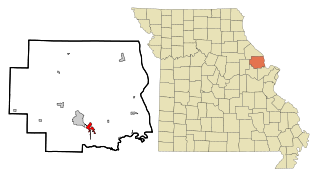
Linneus is a small city in Linn County, Missouri, United States. The population was 281 at the 2020 census. It is the county seat of Linn County.

<span class="mw-page-title-main">Alton, Missouri</span> City in Missouri, United States

Alton is a city and the county seat of Oregon County, Missouri, United States. The population was 707 at the 2020 census.

<span class="mw-page-title-main">Green Ridge, Missouri</span> City in Missouri, United States

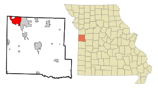
Green Ridge is a city located along Route 127 in Pettis County, Missouri, United States. The population was 476 at the 2010 census.

<span class="mw-page-title-main">Nelson, Missouri</span> City in Missouri, United States

Nelson is a city in Saline County, Missouri, United States. The population was 152 at the 2020 census.

<span class="mw-page-title-main">Bella Villa, Missouri</span> City in Missouri, United States

Bella Villa is a city in St. Louis County, Missouri, in the United States. As of the 2010 census, the city population was 729.

<span class="mw-page-title-main">Flordell Hills, Missouri</span> City in Missouri, United States

Flordell Hills is a city in St. Louis County, Missouri, United States. The population was 822 at the 2010 census.

<span class="mw-page-title-main">Lakeshire, Missouri</span> City in Missouri, United States

Lakeshire is a city in St. Louis County, Missouri, United States. The population was 1,432 at the 2010 census.

<span class="mw-page-title-main">Northwoods, Missouri</span> City in Missouri, United States

Northwoods is a city in St. Louis County, Missouri, United States. The population was 4,227 at the 2010 census.

<span class="mw-page-title-main">Oakland, Missouri</span> City in Missouri, United States

Oakland is a city in St. Louis County, Missouri, United States. The population was 1,381 at the 2010 census.

<span class="mw-page-title-main">Pasadena Hills, Missouri</span> City in Missouri, United States

Pasadena Hills is a city in St. Louis County, Missouri, United States. The population was 930 at the 2010 census. The entire city is listed on the National Register of Historic Places.

<span class="mw-page-title-main">Velda City, Missouri</span> City in Missouri, United States

Velda City is a city in St. Louis County, Missouri, United States. The population was 1,420 at the 2010 census.

<span class="mw-page-title-main">Moscow Mills, Missouri</span> City in Missouri, United States

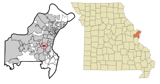
Moscow Mills is a city in Lincoln County, Missouri, United States. The population was 2,509 at the 2010 census.

<span class="mw-page-title-main">Clarkson Valley, Missouri</span> City in Missouri, United States

Clarkson Valley is a city in St. Louis County, Missouri, United States. The population was 2,609 at the 2020 census.

<span class="mw-page-title-main">Warson Woods, Missouri</span> City in Missouri, United States

Warson Woods is a city in St. Louis County, Missouri, United States. The population was 1,962 at the 2010 census.

<span class="mw-page-title-main">Blackburn, Missouri</span> City in Missouri, United States

Blackburn is a city in Lafayette and Saline counties in the U.S. state of Missouri and is part of the Kansas City metropolitan area. The population was 224 at the 2020 census.

References

  1. "ArcGIS REST Services Directory". United States Census Bureau. Retrieved August 28, 2022.
  2. "West Alton MO ZIP Code". zipdatamaps.com. 2023. Retrieved June 16, 2023.
  3. 1 2 "U.S. Census website". United States Census Bureau . Retrieved January 31, 2008.
  4. "US Board on Geographic Names". United States Geological Survey. October 25, 2007. Retrieved January 31, 2008.
  5. "Post Offices". Jim Forte Postal History. Retrieved November 27, 2016.
  6. Eaton, David Wolfe (1918). How Missouri Counties, Towns and Streams Were Named. The State Historical Society of Missouri. pp.  357.
  7. "US Gazetteer files 2010". United States Census Bureau . Retrieved July 8, 2012.
  8. "Census of Population and Housing". Census.gov. Retrieved June 4, 2015.
  9. "U.S. Census website". United States Census Bureau . Retrieved July 8, 2012.